
Grand Opening of Transformative Rail-to-Rail Bike/Walk Path on Slauson Brings Community Out to Play
Despite the chill and intermittent drizzle, the mood at Budlong and Slauson this past Saturday was festive.
“We’ve been waiting for this for so long!” people kept saying.
Indeed they had. The $166 million Rail-to-Rail Active Transportation Corridor project – the 5.5-mile long bike/walk path now officially open between 11th Avenue (at 67th) and the Slauson Blue/A Line station at Long Beach Avenue – had been over a dozen years in the making.

But the Slauson corridor’s right-of-way (ROW) had sat abandoned and neglected for much longer than that.
After freight trains stopped traversing Slauson to get between downtown and the ports in the 1970s, the wide dirt corridor remained like a stubborn scar carved across the community’s midsection. Decades of disinvestment further entrenched the blight.
Residents had long dreamed of better.
Back in the 1990s, when current County Supervisor and Metro Boardmember Holly Mitchell had been Executive Executive Director of the California Black Women’s Health Project, community members had approached her about the possibility of a rails-to-trails project. They had lamented the lack of access to gyms and safe outdoor spaces and talked of how that compounded Black women’s disproportionate experience with obesity and asthma.
“‘You want me to walk,'” she says they told her. “‘But it is less safe for me to walk the streets in my neighborhood than to sit at home waiting for a heart attack to happen.’”
__________
A transit agency evolves
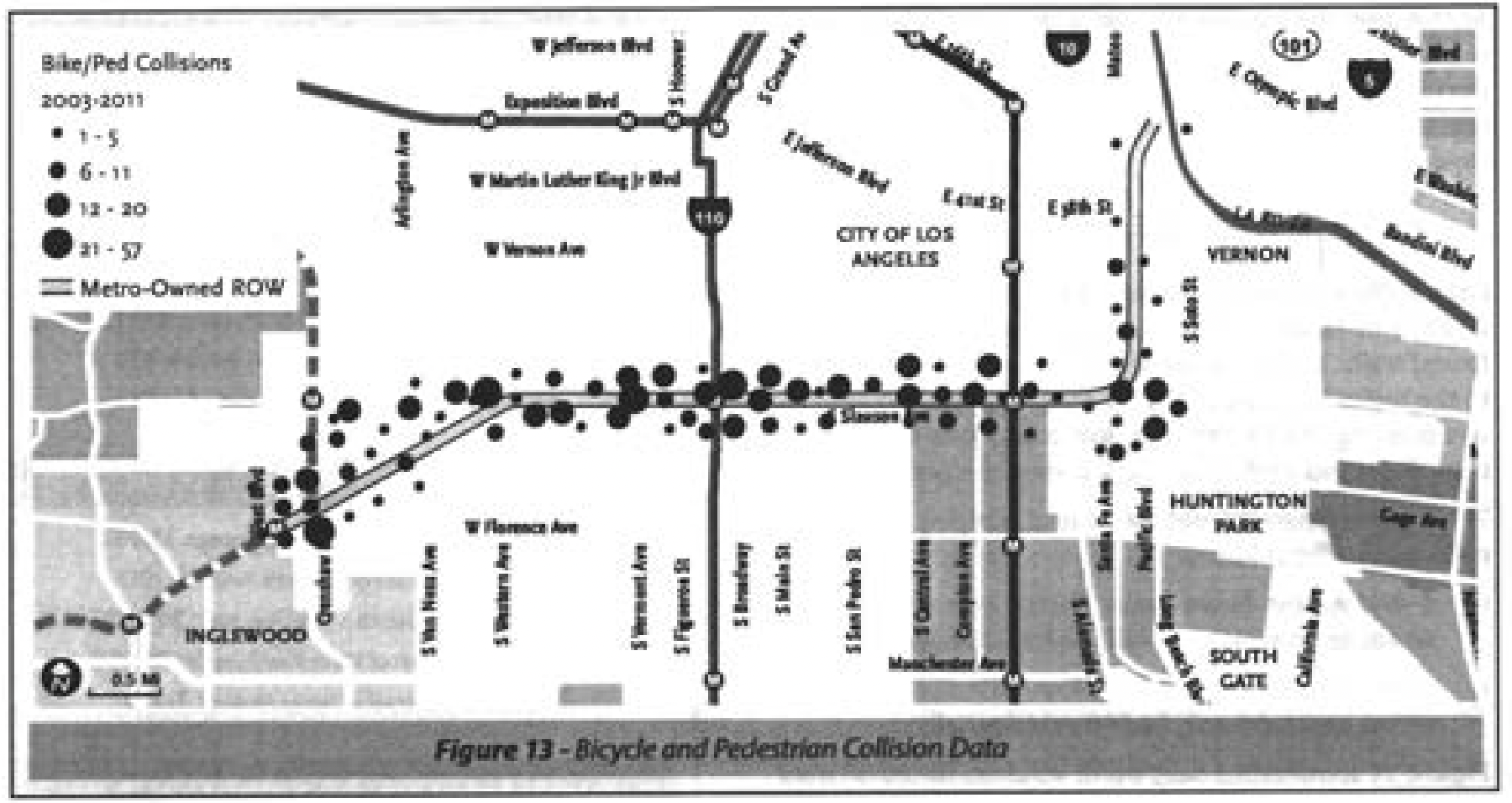
Money for green investments in historically disenfranchised Black and brown communities was never easy to come by.
That, back in 2012, then-Metro Boardmembers Mark Ridley-Thomas and Gloria Molina were actually able to convince Metro the corridor could be transformed into an eight-mile long green ribbon running from Hyde Park to the L.A. River now seems like a minor miracle.
They had understood that framing it as an “active transportation corridor” project – a conduit along which bike and pedestrian commuters could more easily connect to key rail and bus lines – would make it eligible for a number of federal and state grants.
It was still a major undertaking for Metro. As the agency’s current CEO Stephanie Wiggins had noted at the groundbreaking in 2022, this kind of project was outside the scope of what Metro did.

At the time, Metro’s own ROW preservation guidelines (which required Metro reserve its corridor space for future transportation projects) didn’t even recognize bicycles as a formal mode of transportation, something which initially presented a real hurdle for project design.
Seeming to fear residents might ask for more than they could or would provide, Metro initially did very limited outreach. They also stayed hyper-focused on how the project would connect users to transit (as opposed to exploring other community-serving uses) and repeatedly cautioned stakeholders against getting their hopes up.
The arrival of a $15 million TIGER VII grant and an $8.326 million Active Transportation Program grant in 2015 seemed to quell some of those jitters. For the first time, the project was openly touted as a potential “destination unto itself” and catalyst for the economic transformation of the area.

But at that point, Metro had also estimated the Slauson segment of the project would break ground in 2018 and run them a very lean $19 million.
When the costly proposals it got back from design/build contractors shattered those illusions, Metro again had to switch gears.
They changed the project delivery method to design/bid/build and completed the design in-house. They got creative in cobbling together funding from city, county, state, and federal sources and worked closely with elected officials to fill significant funding gaps. And they leaned more heavily on community collaborators, like Slate-Z, which allowed them to expand the scope of the project and incorporate climate-related goals like reducing greenhouse gases, mitigating heat islands, and treating rainwater runoff via bioswales and bioretention planters.
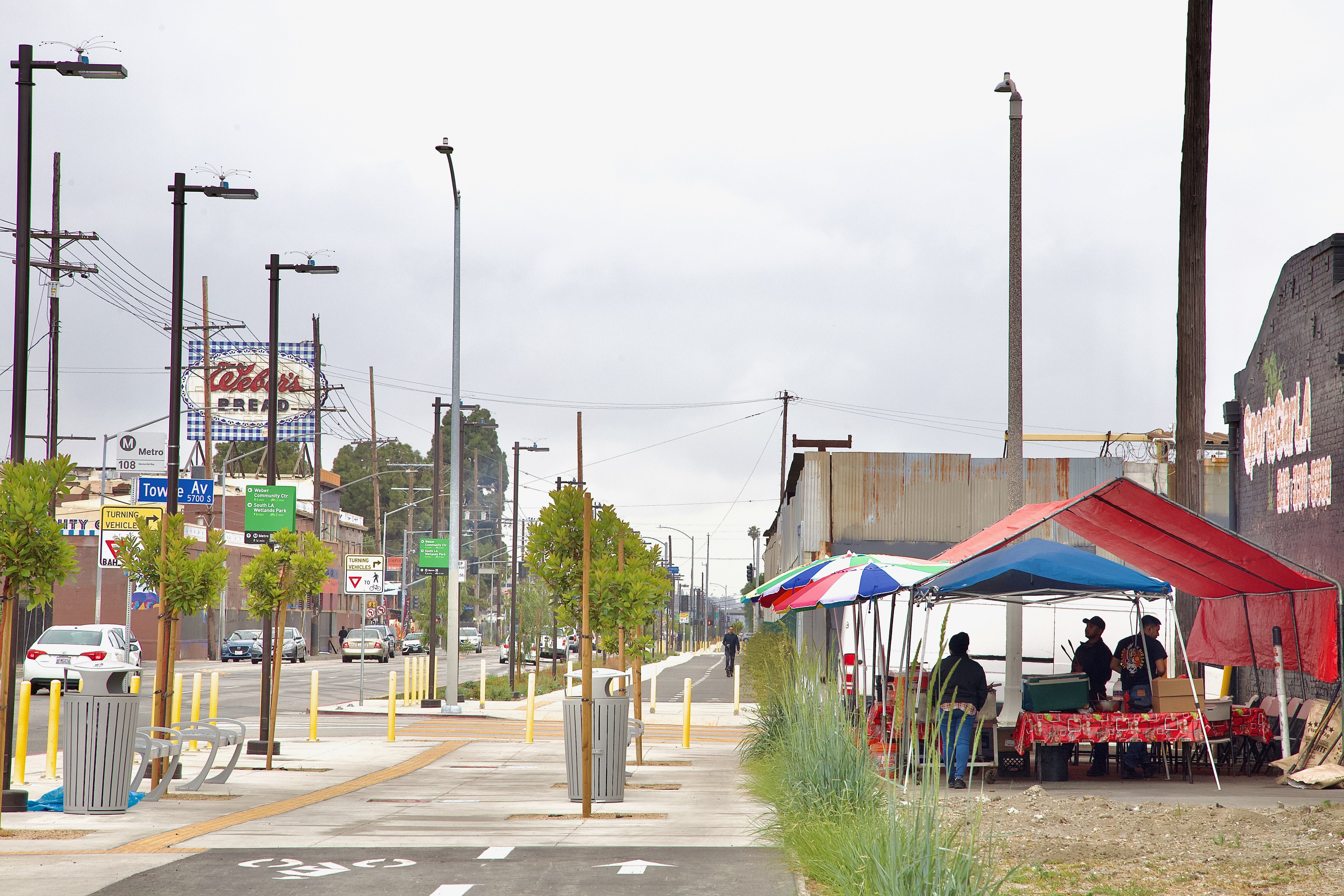
The result is a $166 million project that does much more than just connect path users to two rail stations, 17 Metro bus lines, and three DASH bus lines. It tells South Central residents that they are deserving of investments in beautification, health, nature, and joy.

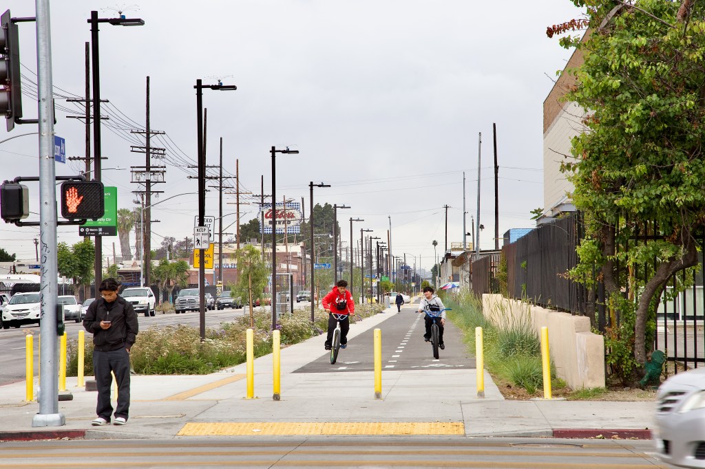
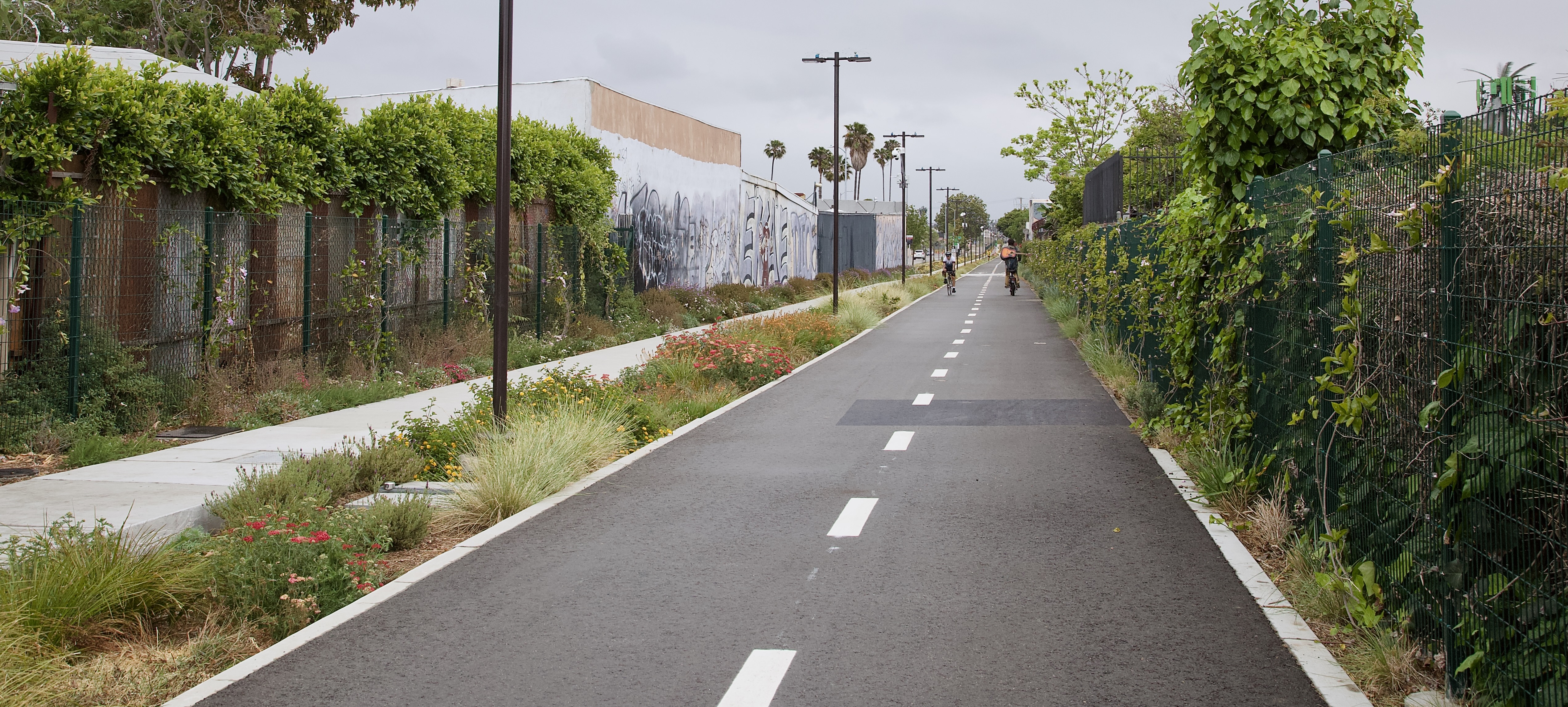
The new path creates space for community and play amidst an explosion of wildflowers, native plants, and trees (472, to be exact) while facilitating access to schools, local businesses, grocery shopping, park spaces, health clinics, services, and more.
The benefits aren’t limited to the path, either. Nearly 500 pedestrian lights bring the corridor out of the shadows, enhancing safety for path users as well as residents in surrounding neighborhoods and those crossing Slauson. There are also 52 security cameras (said to be continuously monitored at the Metro Security Operation Center) and nine emergency telephones installed along the alignment.

There are also five Metro bike-share stations (at Denker, Vermont, Figueroa, Avalon, and Compton) – the first in South Central outside the USC area.
And there is abundant wayfinding signage and seating along the path, especially around busy transit stops.

__________
More than just a ribbon cutting
Congresswoman Maxine Waters certainly seemed pleased with what she saw on Saturday.
“Es muy bonita!” she grinned before confessing “It’s so pretty!” was all the Spanish she knew.
But she also knew what it meant to be able to safely walk around one’s own neighborhood, she told the stakeholders who had gathered for the celebration. And she was so proud that “when I walk down Slauson, I’m not going to be angry at what I see anymore.”

It’s a sentiment many in attendance felt in their bones.
As City Council President and Eighth District Councilmember Marqueece Harris-Dawson alluded to in his remarks, the community had seen a lot of groundbreakings over the years, but it wasn’t always a given that ribbon cuttings would follow.
That said, more ribbon cuttings should be on the horizon. As Ninth District Councilmember Curren Price noted in his remarks, as part of his “South Los Angeles Greenway” plans, the new path will be enhanced by the Slauson Connect project (a “resiliency hub” at Normandie featuring a community center, childcare center, after-school programs, vocational training opportunities, a new rooftop garden, and a two-acre linear park), an affordable housing project at Wall with a four-acre public park, and the Bill Greene memorial park, which has already broken ground on the vacant lot at Figueroa.

Some residents were already eager for more.
Members of the South L.A. Real Rydaz bike club wanted to know how long it would be before the path finally reached the river (more on that here) and whether there was a plan to take it to the beach (there is not).
Others wanted to see more projects like this on other corridors around the community.

A beaming dad watching the festivities said he was just happy to have a place where his young son could learn to ride.
He wasn’t alone. Up and down the corridor, little kids could be seen testing out their scooters, bikes, skates, and footspeed while their parents savored not having to watch for speeding cars.

Big kids enjoyed it, too.
Several practiced their wheelies. Others challenged each other to races. And others just enjoyed being able to ride side by side with their friends.

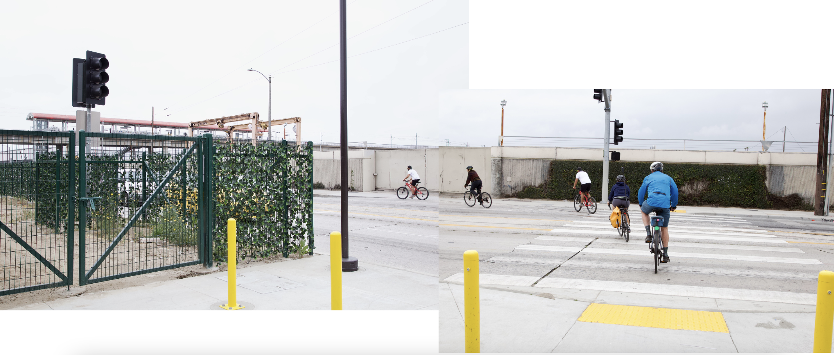
As noisy, grimy, and chaotic as Slauson can be, the bioswales created a remarkably effective buffer.
People could listen to music, be alone with their thoughts, or converse without having to shout over traffic noise. The plethora of benches – especially those set farther back from the street – proved popular with path and transit users alike.

And the intersections – which had always felt incredibly dicey because of the janky train tracks, crumbling asphalt, and eagerness of drivers to get on, off, or across Slauson – felt transformed, thanks to gentle and generous curb cuts, widened and re-striped crosswalks, an abundance of yellow posts, new signals, and additional signage.

__________
What the future holds
As always with a major investment in a historically disenfranchised community, the lingering question is whether the residents it was intended for will be able to retain a foothold in the area long enough to enjoy it.
A bike project in and of itself is not necessarily a catalyst for gentrification. But the arrival of a new amenity can help accelerate turnover already underway and/or invite a law enforcement presence that is responsive to those new users while remaining hostile to existing residents.

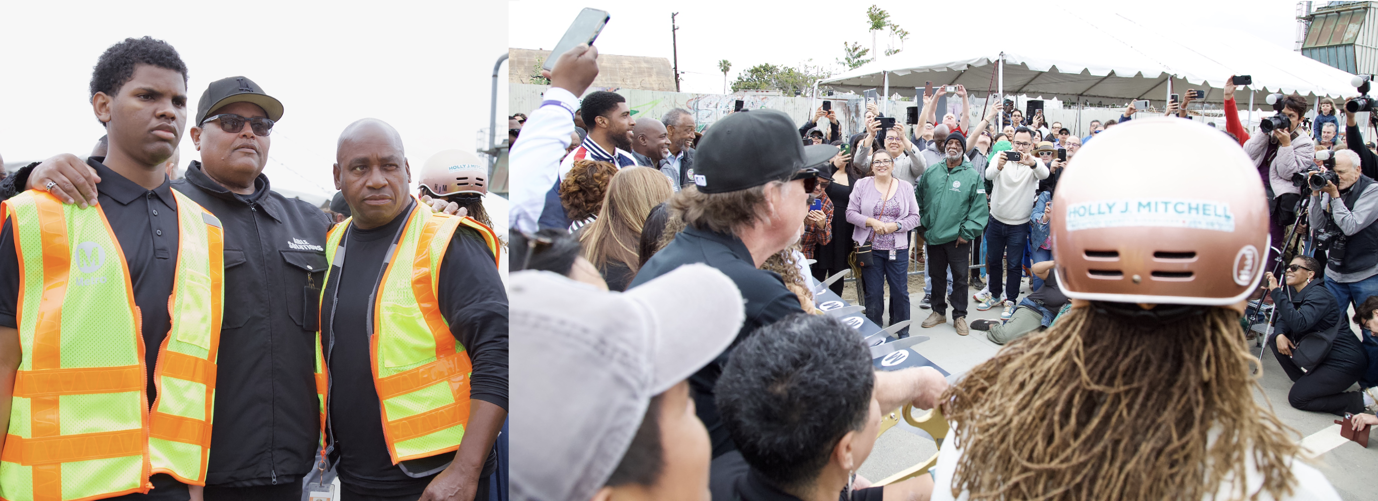
The pilot deployment of local-hire safe passages interventionists is one way Metro is responding to this concern. They will be present along the corridor between the hours of 6 a.m. and 10 p.m.
Proud members of Able Solutions joined in the ribbon cutting celebration (below) and could later be seen greeting and assisting path users and area residents at several spots along its length.
Unfortunately, Metro made no such accommodation for street vendors.
Of the many vendors that were from the community and had been a presence on the corridor for a decade or more, El Pollo del Güero was the only one that had managed to hold its ground.
It hadn’t been easy. Tito, who took over running the stand from his father, said construction had put a damper on their business. There had also been some unpleasant confrontations with Metro over access to their spot on the corner of Towne, he said. But luckily the building owner had had the paperwork to prove the stand was on his property, forcing Metro to back off.
Tito said he had literally grown up on that corner – he’d been there every weekend from the age of two. In those early days, his parents had tucked him under the table. Now, at age 25, just three years older than his dad was when he first set up the stand, he was determined to stay.
__________
More to come
There’s still more to be done to complete the project.
Connection to the Slauson Blue/A Line station: The eastern end of the path currently stops a block short of the Blue/A Line station, meaning cyclists have to brave a brief jaunt on Slauson or roll up onto the sidewalk to make that last connection. When the issue was raised this week at the Metro Board meeting, project staff noted that configuring a connection had proven more challenging than anticipated, but said they are planning on closing that gap.
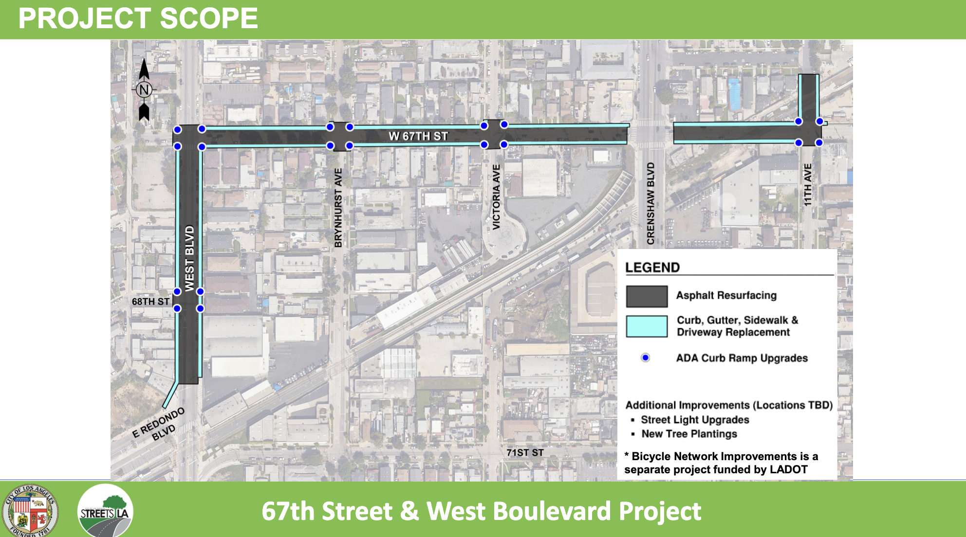
Connection to the Fairview Heights station: Back in 2017, Metro was still working out how to safely get path users from the path’s western terminus at 11th Ave. to the Crenshaw/K Line Fairview Heights station in Inglewood. There was also a tentative plan to turn the orphaned triangle at 67th into a plaza or parklet.
While the status of the triangle is unclear, the connection to the Fairview Heights station has since been handed off to the Bureau of Street Services (StreetsLA) and the L.A. City transportation department (LADOT) as a gap closure project.
StreetsLA has funding from Metro to resurface 67th and West and make pedestrian improvements. LADOT is working on plans for traffic circles at 11th Ave., Victoria Ave., and Brynhurst Ave. on 67th, bike lanes on West, sharrows on 67th, and bike boxes on 67th at both Crenshaw and West. Construction should begin in 2026.
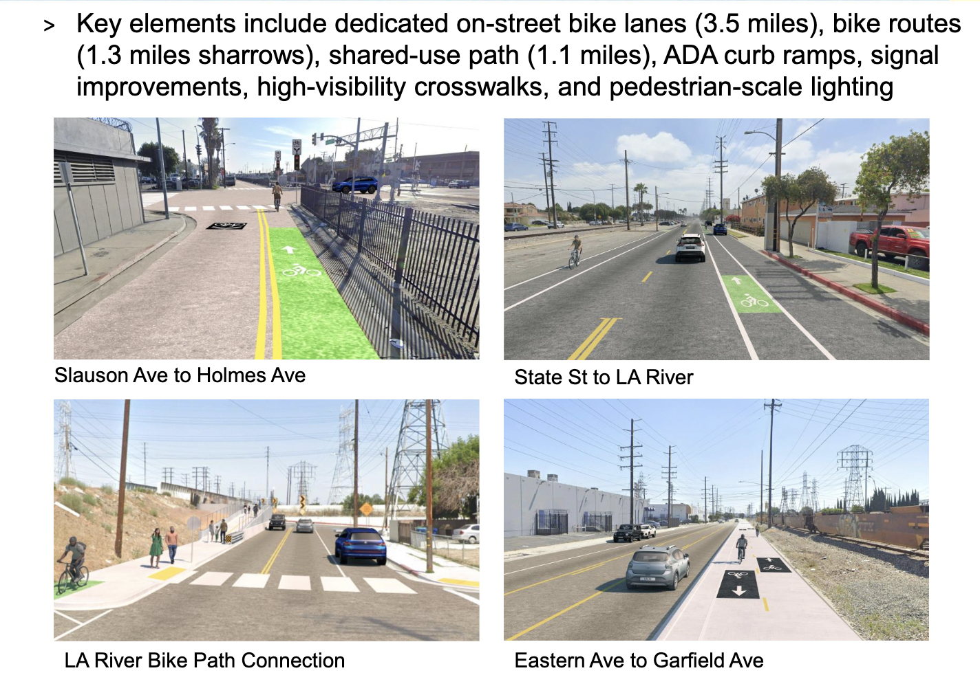
The Rail-to-River segment of the project, which is expected to break ground in late 2025/early 2026 and be completed by 2027, has caused concern among mobility advocates for how much of a downgrade it represents.
That project initially called for separated bike/walk paths to be constructed on the Randolph St. ROW cutting through Bell, Maywood, and Huntington Park.
Metro had to relaunch the planning process in 2021, after it was determined that the Southeast Gateway rail line – which will connect the southeast to downtown L.A. – would run along the 2.3-mile section of Randolph in Huntington Park instead.

Having to negotiate alternative plans with each of the Southeast Cities has resulted in an underwhelming mix of sharrows and on-street bike lanes for the section west of the L.A. River (below).
The cost will be much lower – $10.2 million. But the inferior product will subsequently be unlikely to invite the range of uses or users seen along the path in South L.A.
__________
For more on the evolution of the larger Rail-to-River project, see Streetsblog’s past coverage, below. For more images from the day, check out the IG posts by CMs Harris-Dawson and Price, Sup. Mitchell, and Metro.
- December, 2013: Dear Santa, Please Bring Us an Active Transportation Corridor Along Slauson, but Don’t Forget the Community in the Process (background on the plan; lack of outreach)
- March, 2014: Feasibility Study on Rail-to-River Project Takes Another Step Forward (plan begins to come together; outreach still a major problem)
- October, 2014: Motion to Move Forward on Rail-to-River Bikeway Project up for Vote Thursday (breaks down the feasibility study in more detail, costs, timeline)
- May, 2015: Planning and Programming Committee Recommends Metro Board Take Next Steps on Rail-to-River ATC (more on costs, timelines)
- October, 2015: The Rail-to-(Almost)-River Gets Boost with $15Mil TIGER Grant (yay, actual money!)
- May, 2016: Metro Awards Contract for Environmental Study and Design of Phase I of Rail-to-River Bike Path (OMG it is actually happening; request that outreach finally be meaningful)
- August, 2016: Metro Explores Alternative Rail-to-River Routes Through Southeast Cities (where we learn Metro and the Southeast Cities do not play together well)
- October, 2016: Metro Asks South L.A. Stakeholders: How Would You Use Rail-to-River Bike/Pedestrian Path?
- December, 2016: Rail-to-River Route Through Huntington Park, Bell Emerges as Best Candidate; Community Meeting December 8 (The Randolph Street option emerges as the favorite while also the most expensive and most complicated option; Community Advocates demand Metro handle outreach better and incorporate walking into plans better)
- December, 2016: Preview Some of the Design Options for the Slauson Segment of the Rail-to-River Bike/Pedestrian Path (self-explanatory)
- January, 2017: Metro Seeks Input on Design Options for Segment A of Rail-to-River Bike/Pedestrian Path
- July, 2017: Metro Offers Update on Rail-to-River Bike/Ped Path Design; Project to Break Ground Mid-2018
- December, 2019: Rail-to-Rail Bike/Ped Path along Slauson Delayed but Moving Forward
- February, 2021: Metro Relaunches Rail-to-River Engagement Process to Choose New Southeast Cities Route
- July, 2022: Rail-to-Rail Bike/Walk Path Breaks Ground on Slauson; Officials Speak to Its Significance for Corridor


Read More:
Streetsblog has migrated to a new comment system. New commenters can register directly in the comments section of any article. Returning commenters: your previous comments and display name have been preserved, but you'll need to reclaim your account by clicking "Forgot your password?" on the sign-in form, entering your email, and following the verification link to set a new password — this is required because passwords could not be carried over during the migration. For questions, contact tips@streetsblog.org.


