Motion to Move Forward on Rail-to-River Bikeway Project up for Vote Thursday
In a motion before the Metro Executive Management Committee last Thursday morning, County Supervisor and Metro Board Member Mark Ridley-Thomas cited the successful "transformation of unused or abandoned rail right-of-ways into pedestrian access and bicycle routes" around the country and here in L.A. as support for his call that the Board direct Chief Executive Officer Art Leahy to move forward on the recommendations found in the 212-page feasibility study on the proposed Rail-to-River Bikeway.
Sited along an 8.3 mile section of the Harbor Subdivision Transit Corridor right-of-way (ROW), the project would connect the Crenshaw/LAX rail line to multiple bus lines (including the Silver Line), the Blue Line, the river, Huntington Park, Maywood, and/or Vernon via a bike and pedestrian path anchored along Slauson Ave.
The active transportation corridor (ATC) project, first proposed by Ridley-Thomas and Supervisor and Metro Board Member Gloria Molina in 2012, has the potential to effect a significant transformation in a deeply blighted and long-neglected section of South L.A.
So, it was not surprising to see Ridley-Thomas ask that, when the full Board meets this Thursday, October 23, at 9 a.m., it approve his motion directing Leahy to identify and seek funds from Measure R, Cap and Trade, and other sources to facilitate the environmental, design, and outreach efforts recommended by the Feasibility Report.
Even though Ridley-Thomas' strong support for the project was expected, the motion to move it forward still made me sit up a little straighter.
When I attended the two public meetings held on the corridor project, representatives from both Metro and Alta Planning + Design (consultants on the project) were firm in their suggestions that we not get our hopes up too high. There was no funding attached to the project, they said, and they were only looking at questions of feasibility. These were also the reasons, I was told, for the limited outreach and engagement of the neighbors that live along the corridor.
Not to mention that including the community might have brought other problems with it.
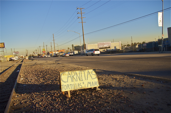
Residents and vendors I have spoken with in the area are fed up with the blight and the hideous condition of the intersections along the tracks. Many want a green space that they can enjoy with their families, where they can relax and/or exercise, connections that would make walking to school or the clinic more pleasant, and where vendors are welcome (many of the long-time weekend vendors live within blocks of the corridor). Meaning that, despite the calculations that an ATC might attract 1.6-3.2 million bicycle trips and 2-4 million pedestrian trips annually by people connecting between the numerous bus and rail lines that crisscross the corridor, it is entirely possible that the neighboring residents would favor a more recreational, park-like corridor than a purely active transportation one.
But converting the space to anything other than an ATC would be difficult, Metro representatives explained to me at the first public meeting.
Just building an ATC along the ROW will prove complicated enough, apparently. The ROW Preservation Policy prohibits the construction of bikeway and/or pedestrian paths unless they can be designed in such a way that they will not have to be relocated to make way for a future transportation project. Since the narrowness of the ROW means that condition cannot be met, Metro would do well to update its preservation guidelines to reflect the October 2013 policy indicating bicycles are a formal mode of transportation.
And as funding would likely come from Metro, any project would therefore have to tie back to transportation. Moreover, although construction of the ATC would entail the removal of existing tracks (something that would happen even with a rail project, as light rail necessitates a different track gauge), preservation policy dictates that the intervention would still be classified as "intermediate" or "temporary." This was not to say that other amenities could not be part of the final design (i.e. fitness equipment, garden boxes), space permitting, I was told, but they would be secondary to the ATC.
Finally, a "recreational" trail or linear park that had primarily recreational benefits, the feasibility report also admonishes, could trigger Section 4(f) of the Department of Transportation (DOT) Act of 1966. Meaning that, once land had become de facto recreational park space, the Federal Highway Administration (FHWA) and other DOT agencies would not be able to approve the conversion of the ROW back to a bus or rail corridor unless there were no feasible alternatives to using that land and the project could be designed to do minimal harm to the existing recreational space (see more on Section 4(f) here).
Somewhat amusingly, these constraints have materialized in the form of multiple warnings throughout the report reminding Metro that residents might become so appreciative of having a nice, active green space in their neighborhood that attempts to convert the ROW back to rail at some future date could make them very upset.
So what is in the feasibility report, is the project something even the neighbors could love, and how much will the whole thing cost?
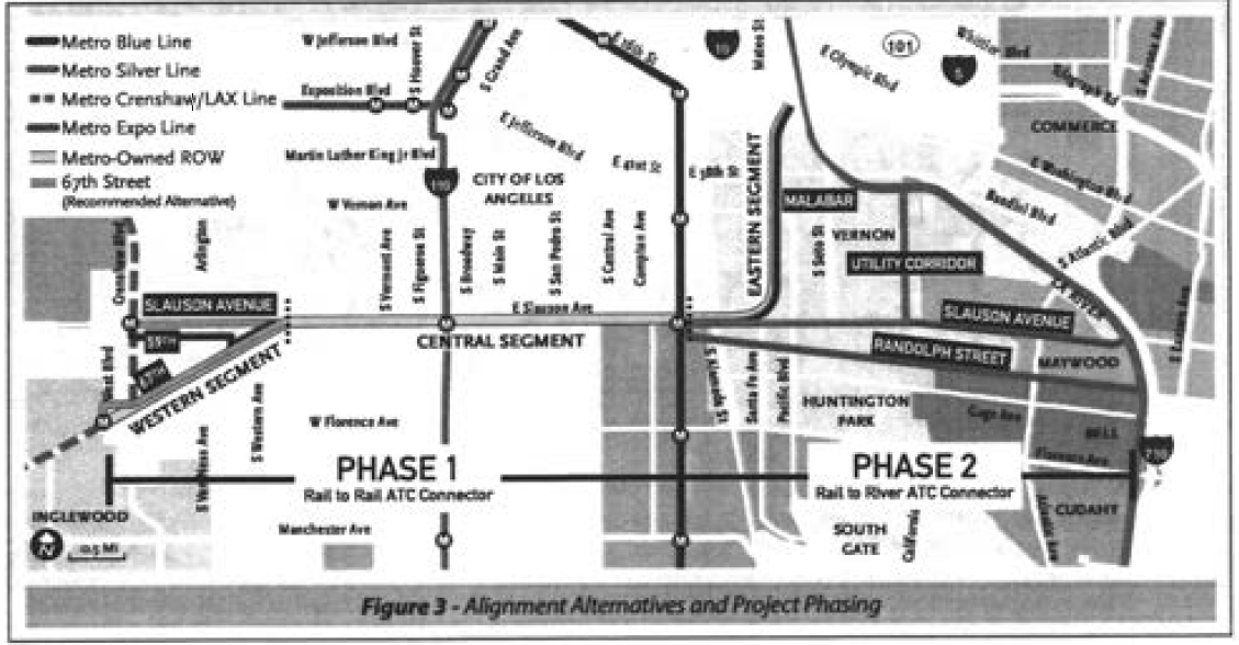
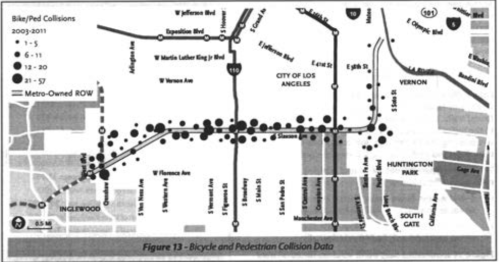
As seen in the map at the top, the corridor is divided up into three segments and the implementation of the project would need to unfold in two phases. Both would take place concurrently, but Phase I would be the easiest to implement and most likely to be completed (possibly within four years), as Metro already owns the affected ROW. Phase 2 could take as long as ten years to complete and would involve lengthy negotiations for access to the ROW.
Phase 1: The Central and Western Segments
Phase I of the project would encompass the Central and Western Segments of the ATC, running between Crenshaw Blvd. on the west end and Long Beach Ave. on the east, and would present the fewest obstacles to implementation, assuming funds were available.
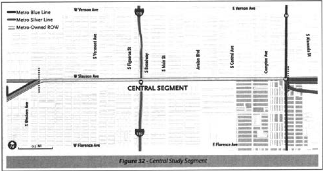
Central Segment
The proposed design for the Central Segment, a 3.6-mile long section of the Slauson corridor between Western and Long Beach Avenues, would cost $12,205,805 to construct and $54,318 to operate and maintain annually.
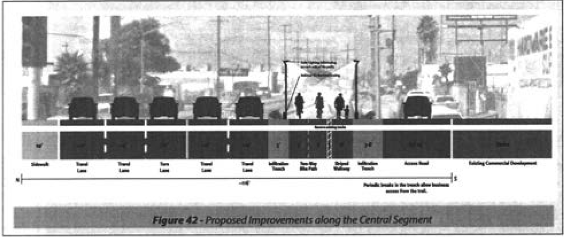
As the ROW is greater than 20' in width, the space could accommodate 5' bike lanes and a 6' pedestrian zone, with a 1' striped buffer between them. Where the ROW is wider than 30', infiltration trenches populated with drought-tolerant and native plantings would filter stormwater run-off.
Other amenities could include enhanced gateways to mark the entrances to schools and parks, upgraded signals at the many intersections the path would cross (to protect users from cars turning right across the ROW), solar lighting, wayfinding and other signage, recycled railroad ties as seating, and (potentially) interpretive signage describing the history of the area, the rail line, and the Slauson family.
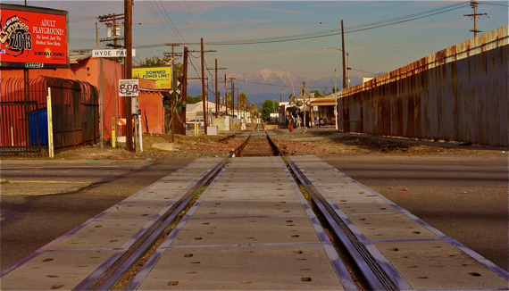
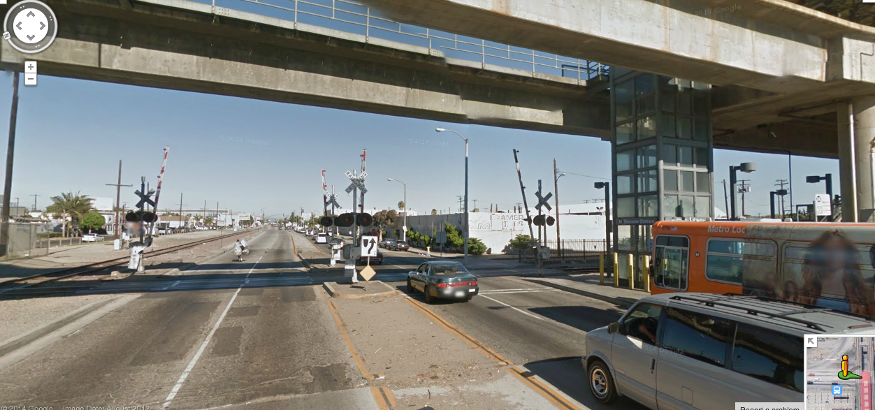
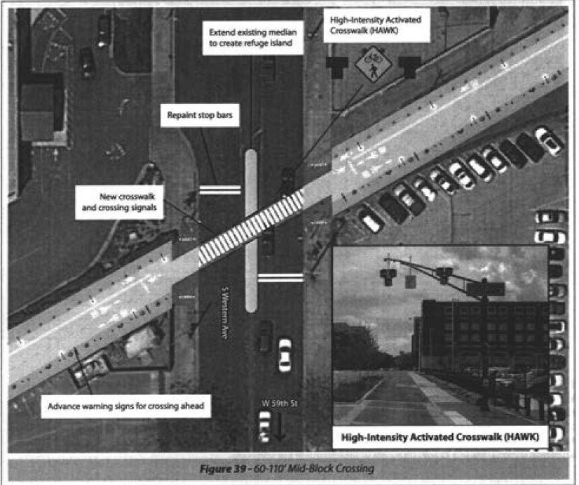
The enhanced crosswalks -- particularly one described for the Blue Line station near Long Beach Ave. where none exist now -- would be a tremendous boon for the community.
Pedestrians looking to cross Slauson now, either to get to or from the Blue Line station or to a specific destination, often walk into traffic underneath the bridge supporting the rail line. It's so commonplace that drivers appear used to the phenomenon and regularly stop to allow pedestrians to cross.
But that doesn't mean it is safe.
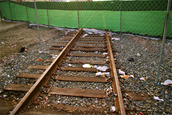
In fact, the great majority of the 40+ crossings found along the corridor have long been pedestrian- and cyclist-unfriendly, particularly those underneath the Silver Line (at center, above, along the 110 fwy). There, people tend to cross mid-block instead of making their way to the crosswalks at the busy on/off ramps.
The improvements that would accompany the ATC, therefore, could have a significant impact on the safety of all users of the Slauson corridor.
Western Segment
The design of the Western Segment, connecting the ATC to Crenshaw, proves a little more complicated.
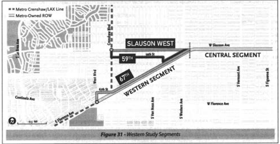
The feasibility report offers three potential ways to move pedestrians and cyclists from Slauson to a terminus at one of two stations along the Crenshaw Rail Line.
Those cycling west along Slauson could merge with into heavy traffic (protected only by sharrows) and continue straight ahead to the future rail station at Slauson/Crenshaw (top in diagram), head down the ROW briefly before detouring onto 59th St. and moving north again to the Slauson/Crenshaw stop (center, in diagram), or stay on the protected ROW for almost 2 miles until reaching 67th St. (bottom route) and heading towards the Florence/Crenshaw station.
Despite the 67th St. option being the costliest -- this 2-mile section would cost $6,600,019 to construct and $25,443 to operate and maintain -- the report is firmly in support of it.
The factors working in its favor include the overall ease of implementation (thanks to the ROW cutting diagonally across streets on its own, independent path), the lowered safety risks for pedestrians and cyclists, the shorter hop cyclists would need to make on side streets to reach the Florence/Crenshaw stop, and the connection with West Blvd., a street which already has bike lanes (enhancing connectivity with the wider bicycle network). And the dimensions of the ROW would allow for it to have many of the amenities that would be present along the Central Segment.
Because the ROWs along the Western and Central Segments of the corridor are already managed by Metro and the ATC would serve a rail-to-rail function (connecting the Crenshaw and Blue Lines), work on both the design and environmental review for that 5.6-mile section of the project could begin immediately.
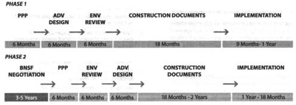
The report estimates that moving Phase I of the project through the public process, completion of the design and environmental review, preparation of the construction documents, and implementation of the project could take approximately 4 years (below).
Phase 2: The Eastern Segment
Although the report recommends that Phase 2 be conducted concurrently with Phase 1, it promises to be a much more complicated process and may take as long as 10 years to be completed (above).
The reason is that Metro would have to negotiate with BNSF to get it to abandon its rights to the Malabar Yards ROW east of Santa Fe Ave. And, considering that a similar negotiation for an inactive section of rail along the Crenshaw Line took three years and cost $4.5 million, they're apparently not expecting this to be easy.
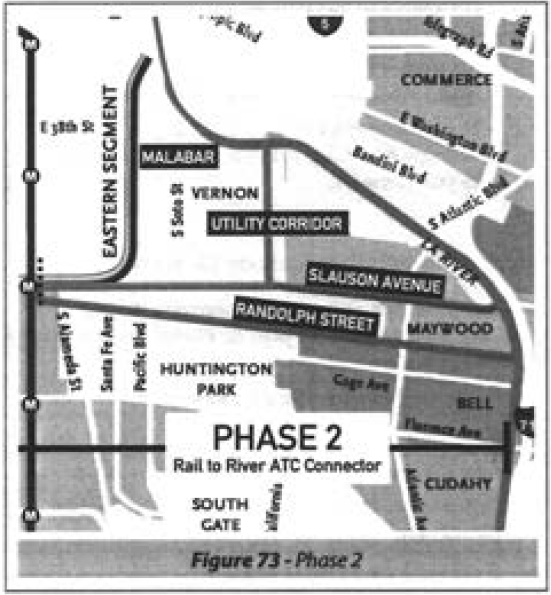
That said, it isn't clear that the Malabar Yards option will be chosen as the primary route for the ATC.
The study clearly comes down in favor of extending the ATC along Randolph St. (a Union-Pacific owned ROW) to connect commuters with the river. It was the highest ranked option, when user experience, connectivity, safety, and ease of implementation were taken into account (see p. 76), and would "legitimize an existing informal active transportation corridor, serve residents and visitors to the Los Angeles River, and provide a connection to downtown Huntington Park."
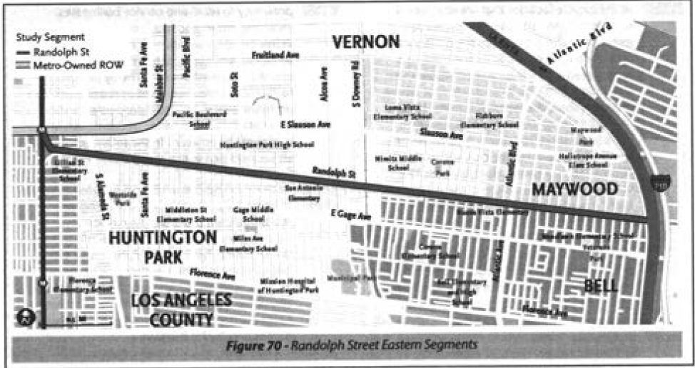
The Randolph St. option would also allow cyclists to continue on a dedicated Class I bike path with with many or more of the amenities present on the Western and Central Segments for the majority of the route, as the ROW is as wide as 60' in some sections.
Along other routes, users will have to move back and forth between busy streets and dedicated Class I facilities, or lose the bike and pedestrian paths altogether.
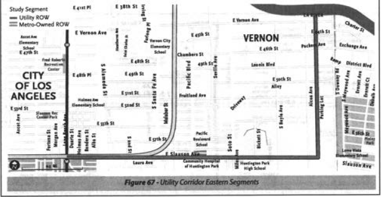
The Utility Corridor option (above), for example, has the advantage of connecting users with Vernon and the river, but would force them to ride alongside heavy traffic on Slauson first.
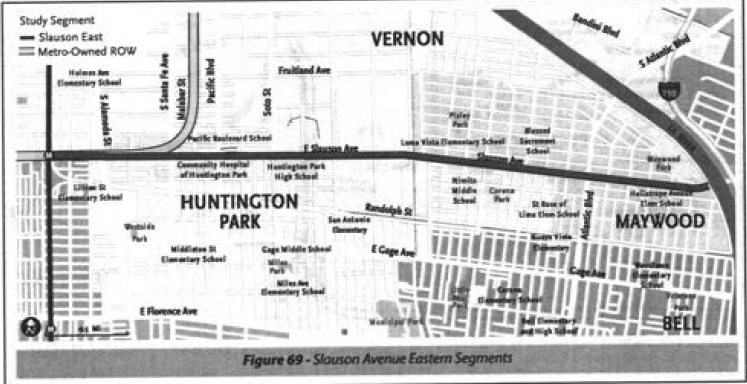
Similarly, the Slauson option (above), which would take users to the river, would offer even less protection for cyclists -- they'd only have sharrows most of the way.
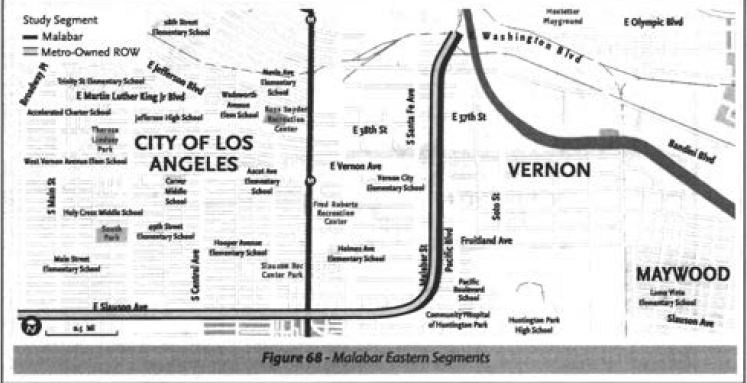
And the Malabar option (above), while able to provide cyclists with a dedicated bike path, narrows considerably (pushing pedestrians onto sidewalks) and would move them through empty industrial areas before connecting them with Washington Blvd.
Costs
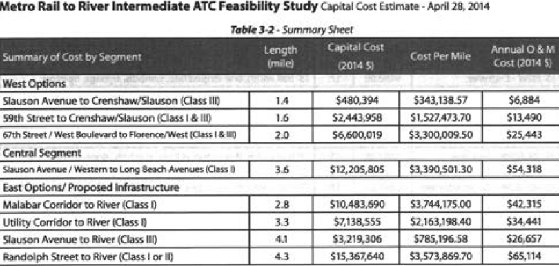
The estimated cost for the 4.3 mile long Randolph St. option would be approximately $15,367,640, with an annual operating and maintenance cost of $65,114. The total costs for the entire corridor project would be approximately $34.2 million to build, and $145,000 a year to maintain. The cost calculations, however, do not include those associated with the BNSF easement abandonment.
The total cost for Phase I would be $18,805,825 to build and $79,761 to operate and maintain.
Even just Phase I is not going to come cheap, in other words.
The report makes clear funding would have to be cobbled together from a variety of sources. It points to a number of potential sources, including Prop C funds for bicycle paths, Cap and Trade funds, Metro Call for Projects, Caltrans Active Transportation funds, and the Metro ExpressLanes Net Toll Revenues. It also cites the need to work with the various local jurisdictions the route would cross through (both to help them access grants and implement the project), to build public-private partnerships that could offer access to innovative sources of funding, and to work with the community to make them partners in safeguarding the health and well-being of the final product and its users.
Even so, Ridley-Thomas argues in his motion, beyond fixing the blight plaguing sections of South L.A., the project is worth the investment in light of Metro's transportation goals:
A bike and pedestrian path...would provide significant enhancements to the regional transportation network, while creating an innovative environmental, economic, and recreational benefit for the surrounding communities. Such a use would meaningfully facilitate first mile/last mile connections to our public transit system and is supported by Metro policies and programs, including the adopted 2009 Long Range Transportation Plan (LRTP), and the 2014 Short Range Transportation Plan (SRTP), that encourage bicycling and walking as active and sustainable, emission-free transportation options.
Personally, I feel the project is incredibly worthwhile, even if the ATC isn't used specifically to connect to transit in the way the report projects.
This area of South L.A. has been marked by disinvestment for too many years. It is intensely park-poor and was once a neglected ethnic enclave, as racially restrictive covenants kept people of color from being able to own property outside the zone bound by Main, Slauson, Alameda, and Washington.
Today, the neglect has led to some residents in the area feeling like they have to visit other neighborhoods to find safer, more suitable places to pursue health.
This project could change that.
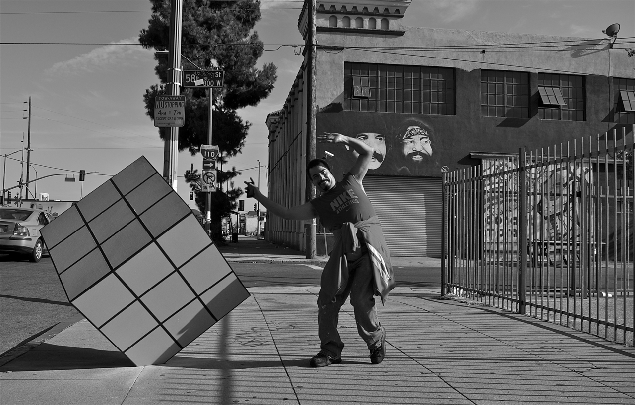
The two health clinics and the many schools that are along Slauson will be able to incorporate the corridor into their health curricula for their students and patients. They could serve as great partners in helping to keep it active, safe, and welcoming for all via fitness clubs or gardening, educational, or public art projects (there's already a Rubik's Cube along Broadway just north of Slauson, courtesy of design-build company Conant-Moran, and it's managed to change the feel of that block). The transformation of the corridor could even provide a boost to the economy, if the existing vendors and other stakeholders (particularly local small businesses) were seen as partners in activating the ATC.
Allowing for the ATC to be more than just an ATC will also, albeit indirectly, further Metro's goals. The more people feel comfortable enjoying public space in their neighborhoods, the more appealing the corridor will be to those looking to either connect with transit or eschew it altogether in favor of a good, long, bike commute.
What say you about the project?
The full Metro Board will be voting on Ridley-Thomas' motion this coming Thursday morning. You can attend the Board meeting, slated to begin at 9 a.m. in the Board Room at One Gateway Plaza, or send a letter of support (or objection, if that's the camp you fall into) to Metro Board Secretary Michele Jackson at JacksonM@metro.net.
You can find the full feasibility report and information about prior studies looking at rail projects along that corridor (and the decisions to abandon them) here.
Stay in touch
Sign up for our free newsletter
More from Streetsblog Los Angeles
Freeway Drivers Keep Slamming into Bridge Railing in Griffith Park
Drivers keep smashing the Riverside Drive Bridge railing - plus a few other Griffith Park bike/walk updates

This Week In Livable Streets
Bike Month, Hyperion street safety, Eastside rail plans, Pasadena transit, CicloIRVINE, Culver City bus service, and more
Active Streets Mission-to-Mission – Open Thread
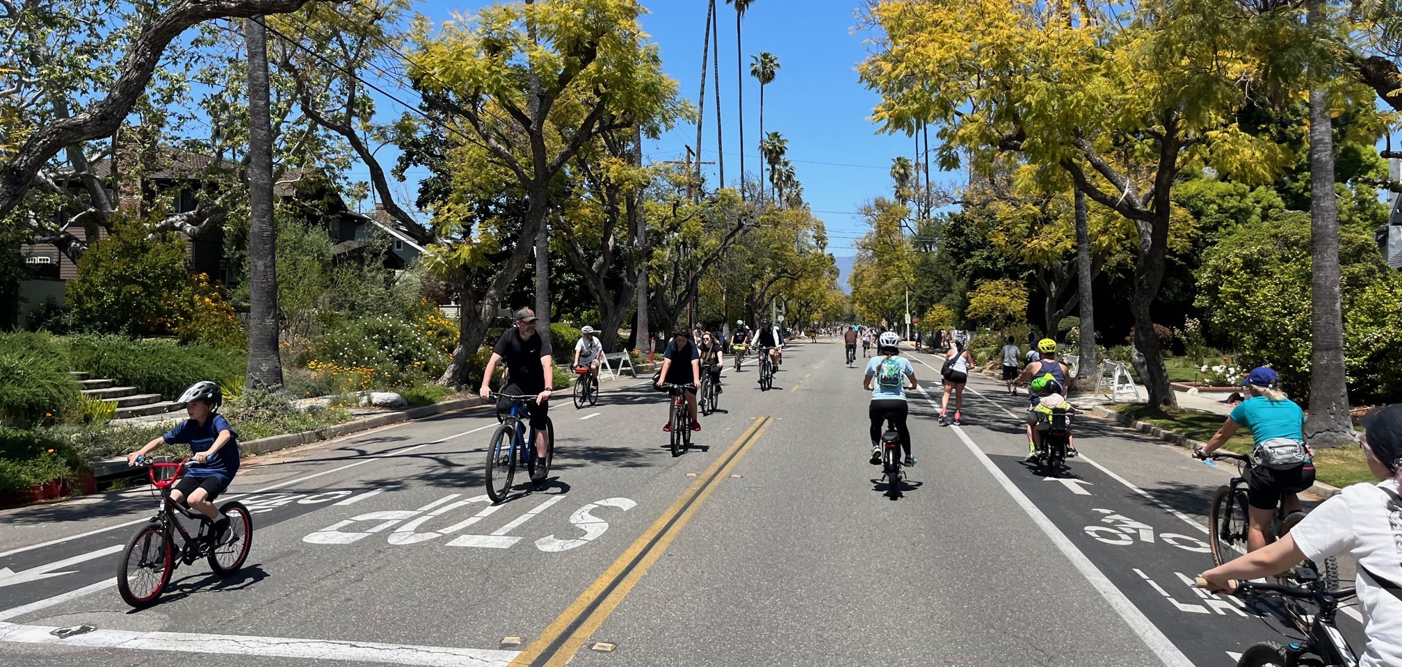
Tens of thousands of participants biked, walked, skated and scootered on car-free streets through San Gabriel, South Pasadena and Alhambra