Rail-to-Rail Bike/Ped Path along Slauson Delayed but Moving Forward
The last time I wrote about Metro’s Rail-to-River project was back in mid-2017, when Metro was preparing to send out an invitation for bids (IFB) to potential design/build contractors.
While there was much more that needed to be done with regard to making the bike and pedestrian path planned for the Slauson corridor more community-serving and -uplifting (as opposed to just facilitating passage through the community), things seemed to be falling into place with regard to getting the project off the ground. Metro even expected to begin construction on the western rail-to-rail portion (Segment A, in green, above) in mid-2018.
As we close out 2019, however, ground has yet to be broken. And it will likely remain unbroken for another year.
Metro had originally received three proposals for the design/build project when it first issued an IFB over a year ago, but all three were rejected for being well above budget.
To minimize both the risks associated with having to seek city approvals and some of the other factors that drove bidders’ projected costs so high, Metro subsequently changed the project delivery method to design/bid/build. Now instead of the contractor and design consultant producing the conceptual drawing and approved-for-construction design, Metro is completing a design that will be fully approved for construction before potential contractors are invited to bid on it.
At present, Metro reports, the design is almost complete and is going through the final plan review stage with the city and county.
An IFB for the project should therefore be released in the summer of 2020, and a contractor brought on board in the fall (assuming the design is approved on schedule). Construction should take approximately 24 months, meaning it would likely be completed by the end of 2023 or early 2024.
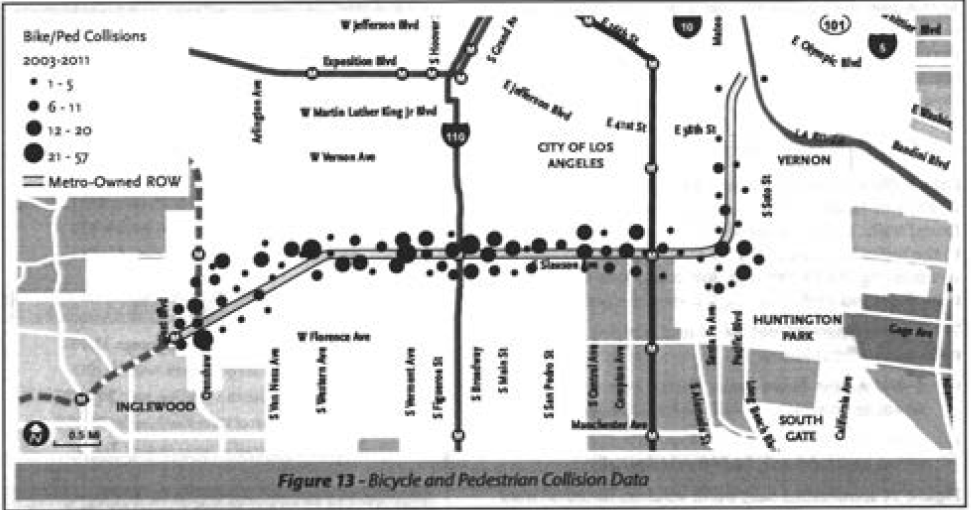
The project seeks to make a corridor that is profoundly hostile to those who walk or roll along and across it much more accessible and welcoming.
First proposed by Metro Board members Mark Ridley-Thomas and Gloria Molina in 2012, the goal of the project was to convert a right-of-way (ROW) deemed infeasible for passenger rail in 2009 (see the Harbor Subdivision study here) into a community asset in an intensely park-poor area.
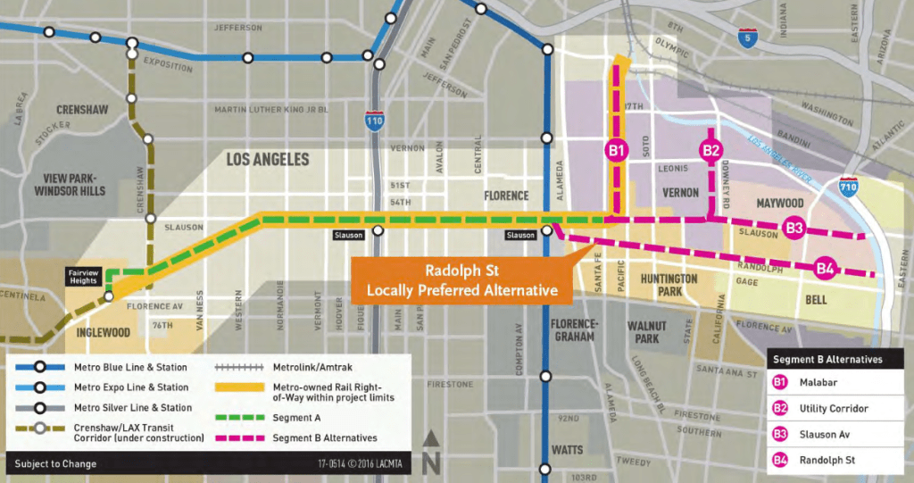
Over the next four years, the Metro board adopted the feasibility study for the path, received a $15 million TIGER grant to push the design and construction process along, decided to pursue acquisition of the ROW along Randolph through the Southeast Cities for Segment B, and produced a preliminary (30 percent complete) design of what the transformed corridor could look like.
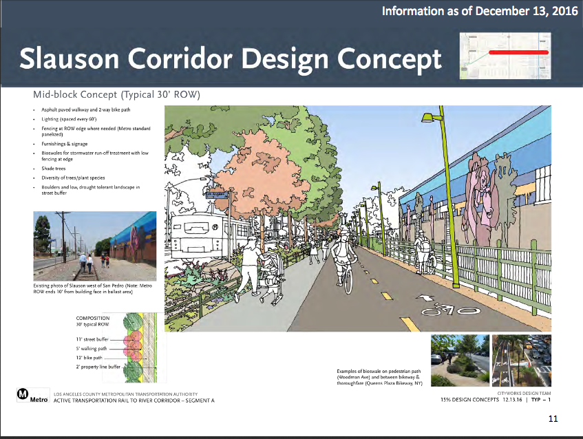
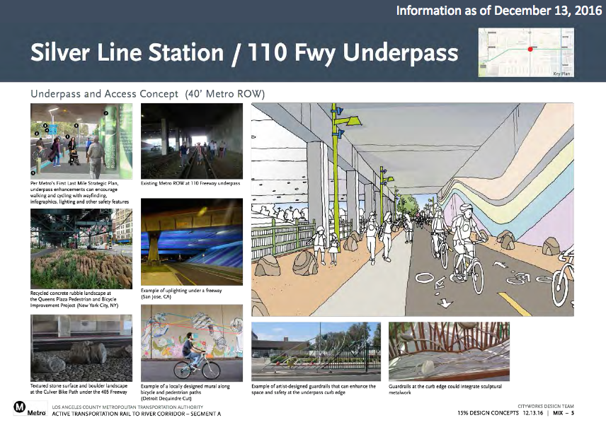
Segment A, the 6.4-mile “rail-to-rail” portion of the project that largely follows Slauson, is intended to facilitate transit users’ movement between local bus lines, the Silver Line, the A/Blue Line, and the soon-to-open Crenshaw Line.
Metro is able to proceed with the work along Segment A because it already owns that ROW. In contrast, the design and construction of Segment could take a decade or more because Metro must negotiate with Union Pacific to access the ROW along Randolph Street and work out plans with each of the Southeast Cities the path will pass through on its way to the connect with the river.
We’ll continue to post updates as the project moves forward. In the meanwhile, check below for all our past coverage or visit Metro’s project page: Metro.net/projects/R2R. Appreciate our coverage? Donate and be entered into a raffle to win a book! Details here.
- December, 2013: Dear Santa, Please Bring Us an Active Transportation Corridor Along Slauson, but Don’t Forget the Community in the Process (background on the plan; lack of outreach)
- March, 2014: Feasibility Study on Rail-to-River Project Takes Another Step Forward (plan begins to come together; outreach still a major problem)
- October, 2014: Motion to Move Forward on Rail-to-River Bikeway Project up for Vote Thursday (breaks down the feasibility study in more detail, costs, timeline)
- May, 2015: Planning and Programming Committee Recommends Metro Board Take Next Steps on Rail-to-River ATC (more on costs, timelines)
- October, 2015: The Rail-to-(Almost)-River Gets Boost with $15Mil TIGER Grant (yay, actual money!)
- May, 2016: Metro Awards Contract for Environmental Study and Design of Phase I of Rail-to-River Bike Path (OMG it is actually happening; request that outreach finally be meaningful)
- August, 2016: Metro Explores Alternative Rail-to-River Routes Through Southeast Cities (where we learn Metro and the Southeast Cities do not play together well)
- December, 2016: Rail-to-River Route Through Huntington Park, Bell Emerges as Best Candidate; Community Meeting December 8 (The Randolph Street option emerges as the favorite while also the most expensive and most complicated option; Community Advocates demand Metro handle outreach better and incorporate walking into plans better)
- December, 2016: Preview Some of the Design Options for the Slauson Segment of the Rail-to-River Bike/Pedestrian Path (self-explanatory)
- January, 2017: Metro Seeks Input on Design Options for Segment A of Rail-to-River Bike/Pedestrian Path
- July, 2017: Metro Offers Update on Rail-to-River Bike/Ped Path Design; Project to Break Ground Mid-2018

Read More:
Streetsblog has migrated to a new comment system. New commenters can register directly in the comments section of any article. Returning commenters: your previous comments and display name have been preserved, but you'll need to reclaim your account by clicking "Forgot your password?" on the sign-in form, entering your email, and following the verification link to set a new password — this is required because passwords could not be carried over during the migration. For questions, contact tips@streetsblog.org.