Some Actionable Transportation Ideas for L.A. City Councilmember-Elect Katy Young Yaroslavsky
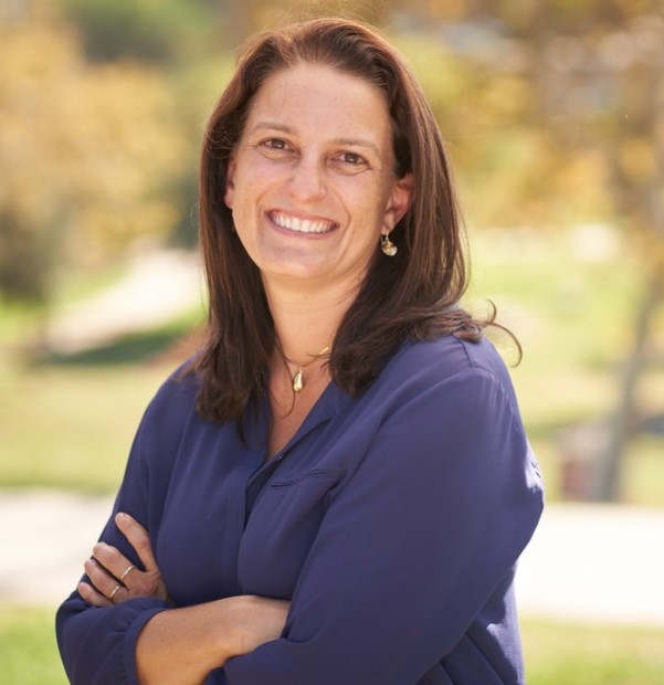
Councilmember-elect Katy Young Yaroslavsky was recently elected to represent L.A. City Council District 5, on the city’s Westside. The seat was vacated by termed-out Councilmember Paul Koretz, who had a long record of opposing bike/walk safety projects and transit-oriented development.
Young Yaroslavsky is an environmentalist with a record of accomplishments toward healthier air, water, and climate. She ran on a platform calling for “smarter land use planning” for “building out affordable housing and creating mixed-use, walkable, bikeable, diverse urban neighborhoods and business districts” as well as supporting transit-oriented development:
With the Metro [D (Purple) Line extension subway] coming through the district for the first time in nearly 60 years, we have an incredible opportunity to locate housing at all income levels, but in particular, affordable and workforce housing, near our jobs centers and transit hubs, while leaving single-family neighborhoods untouched. By creating opportunities for working people to live closer to where they work, we can create vibrant, diverse, and more equitable communities in Council District 5.
She further notes that this “promotes the important work of getting Angelenos out of their cars and will decrease the Westside’s notorious traffic.”
Young Yaroslavsky called for accelerating the build-out of a world-class mass transit system. She supports “thoughtfully but quickly building out a connected network of protected bicycle lanes” and making L.A. a “great walking city” by repairing sidewalks, investing in and maintaining a healthy street tree canopy, and making intersections safer for pedestrians. She also supports first/last mile improvements, micro-mobility, e-bike/e-scooter rebates, and electric vehicles – including bus, municipal fleets, and ensuring that EV charging infrastructure prioritizes less affluent neighborhoods and multi-family housing.
As with earlier SBLA council district ideas posts (see recent CD1, CD4, and CD14 pieces), this post focuses on potential bus, walk, and bike projects located within the boundaries of CD5. Streetsblog checked in with a some L.A. transportation advocates (including incorporating much of Streets for All founder Michael Schneider’s 2021 CD5 post), and took a long look at Young Yaroslavsky’s district to come up with a list of ideas on how the new councilmember might implement her walkable bikeable transit-oriented vision.
First, where is CD5?
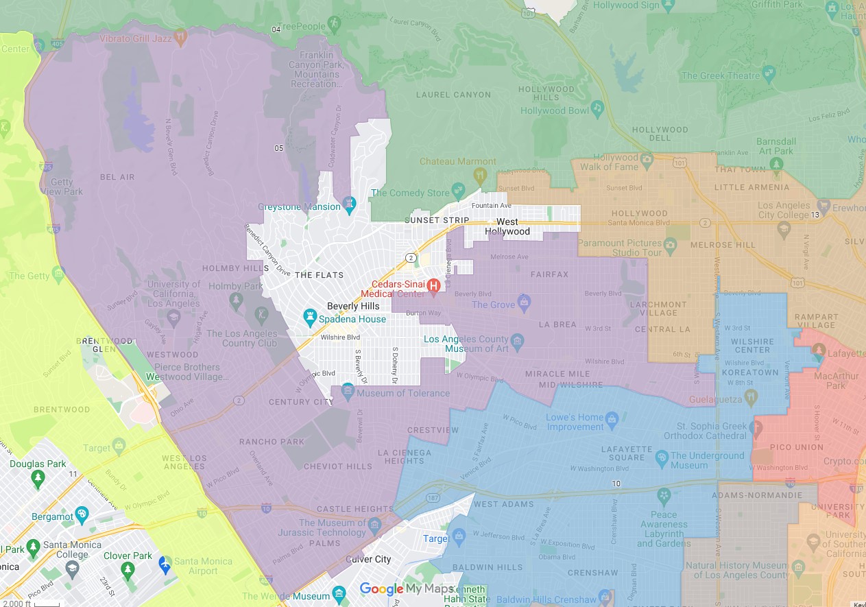
District 5 borders on Culver City, West Hollywood, and Beverly Hills. CD5 communities include Bel Air, Century City, Cheviot Hills, Fairfax, Mid-City, Mid-Wilshire, Palms, and Westwood. It’s a district that includes car-centric well-off single family home neighborhoods many in hillside areas, but also – especially at the southern and eastern ends – fairly population-dense neighborhoods, mostly flat, with good bones supporting existing transit/walk/bike usage and capable of building on it.
Young Yaroslavsky knows that fostering a multi-modal CD5 will mean striking a delicate balance. Ambitiously prioritizing green transportation in the wealthier more car-centric communities in the west and north ends of the district could court a backlash (not unlike what took place in CD11). It would be great to, say, complete the Wilshire bus lanes through the condo canyon neighborhood, but the political costs probably don’t quite justify the substantial benefits to equity and sustainability. The more fruitful opportunities are likely to be in the denser flatter areas, around current and under-construction Metro rail stations, and in support of existing walkable retail areas.
What follows is a long list of potential CD5 projects that support transit, walking, and bicycling. The list mostly focuses on fairly easy fairly quick projects, though it does include some more ambitious facilities, too.
PLANNING
Plan for transit-oriented development
Young Yaroslavsky’s predecessor Koretz sabotaged the city’s plans for more (in Young Yaroslavsky’s words) “affordable mixed-use, walkable, bikeable, diverse urban neighborhoods” near Metro E Line stations. At a minimum, it’s time to dust off the Planning Department’s original Exposition Corridor Transit Neighborhood Plan proposal, and go through the processes of restoring the housing cut by Koretz. Even better, find ways to modify/upgrade the plan to expand areas allowing mixed-use development.
One Expo-adjacent neighborhood that should allow more mixed-use would be Palms, specifically the multi-family residential streets an easy walking distance south of Palms Station. These include Palms Boulevard, and perhaps station-adjacent parts of other streets, such as Clarington Avenue, Exposition Boulevard, Hughes Avenue, and National Boulevard. Palms is notably among the top ten most population-dense neighborhoods in Southern California, and already served by the E Line and frequent buses. Despite the city’s plans to make it more like every other car-centric suburb, Palms already fits much of Young Yaroslavsky’s vision for urban neighborhoods. Palms would benefit from transit-oriented development, and prioritizing walking and biking.
(CD5’s Westwood and Bundy stations could use more mixed-use too, but neighbor resistance would likely limit what can be done there.)
CD5 should pursue similar transit neighborhood plans for under construction CD5 D Line stations in Mid-City and Westwood, but will have to contend with similarly resistant homeowners.
BUS/RAIL
Install new bus lanes
CD5 streets carry quite a few high-ridership transit lines, mainly on east-west arterials. The district already has bus lanes on Wilshire Boulevard. La Brea Boulevard and Venice Boulevard will be receiving bus lanes this month or next. CD5 is also home to a couple of existing Expo Line stations, and a couple of under-construction D Line extension stations.
The first order of business should be to make sure that LADOT doesn’t back off of planned bus lanes on La Brea and Venice. Young Yaroslavsky can blame these on her predecessor, but needs to not allow an officeholder transition to derail bus speed improvement projects already well underway.
From there bus improvements get difficult. Future expansion of the bus lane network could focus on installing bus lanes already approved in the city’s Mobility Plan (MP2035). The facilities listed below are already approved (and would be part of automatic upgrades if voters approve Healthy Streets L.A. in 2024), but none are easy:
- Crenshaw Boulevard – Wilshire Boulevard to Olympic Boulevard. CD5 includes about a half-mile of Crenshaw Boulevard which carries Metro line 210. New bus lanes there would mean significant on-street parking removal. An early first step might be to do a couple blocks long bus-only right-turn bus lane (somewhat similar to Aliso Street) to facilitate the northbound 210 turning onto Wilshire.
- Santa Monica Boulevard – 405 Freeway to Beverly Hills. The city approved Santa Monica Boulevard bus lanes would extend about two miles in CD5. The city reconfigured much of this over-wide former rail right-of-way over a decade ago – mainly to add car capacity, while adding unprotected bike lanes. With the nearby Century City D Line stations opening soon, it is probably time to consider installing the bus lane (while adding protection to the meager bike lanes), though that will involve reconfiguring lanes currently for driving. It is difficult to imagine any interim (or full) portion of this that might be worthwhile for transit riders without triggering driver backlash. But an early first step might be a few blocks of westbound bus lanes in Century City combined with a queue-jumper.
- Sepulveda Boulevard – Ohio Avenue to Venice Boulevard. These lanes would serve both Metro line 761 and Culver City Bus line 6 between the Sepulveda Expo Station and Santa Monica Boulevard, but would require serious political will to reconfigure car lanes.
- Westwood Boulevard – Wilshire Boulevard to UCLA. This stretch is currently served by Metro line 761, Big Blue Bus, Culver City Bus, and campus shuttles. The former councilmember famously quashed a campus bike connection, but, with a new councilmember (and Metro D Line subway) arriving, it is high time to look at how to make it easy to get from Wilshire to UCLA.
Not yet in MP2035, but needed, are bus-lanes on high ridership bus lines in the east end of CD5 (likely in collaboration with CD10 and/or CD13): 3rd Street, Beverly Boulevard, Pico Boulevard and Olympic Boulevard.
Support camera enforcement of existing bus lanes
The city is working with Metro to pilot on-bus camera enforcement on Wilshire starting in 2023 (see Council File 21-1224). This pilot needs council approval – and the council office can be helpful in getting the word out to drivers to stop blocking bus lanes. Council support will be needed to expand the program to other streets in the bus lane network.
Support current and future Metro subway construction
This should go without saying, but Young Yaroslavsky’s predecessor has gotten in the way of current D Line subway construction, causing delays and driving up costs. The city needs to support Metro’s timely completion of current under-construction subway extensions.
Support Metro building a real Sepulveda Transit Project subway that really serves UCLA, not a ridiculous monorail.
WALK
CD5 is home to many walkable areas – including Westwood, Melrose, Mid-Wilshire, and Palms. The most fruitful initial walkability improvements would likely focus on these areas, especially where they overlap with first/last mile connections to existing Metro stations (E Line: Culver City, Palms, Westwood, Sepulveda) and future ones (D Line: La Brea, Fairfax, La Cienega, Century City/Constellation, and Westwood) and where they connect with progressive pro-walk/bike/transit cities of West Hollywood and Culver City.
Plan for first/last mile connections
Metro has studied walk/bike connections to future D Line stations (see Metro plans for: section 1, and sections 2 and 3 – examples below). These documents are an excellent source for walk and bike improvements needed to get people to the new subway stations.
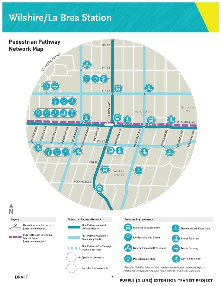
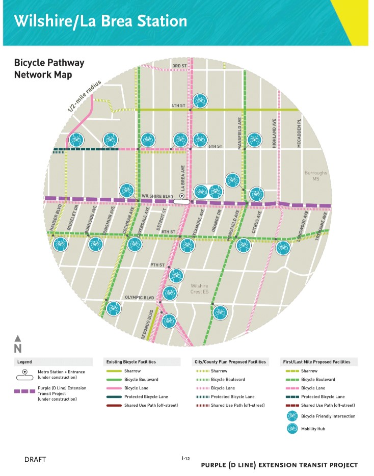
Unfortunately, the agency’s first/last mile planning efforts didn’t fully kick into gear until after Expo opened. And Metro’s first/last mile plans don’t have much teeth, as nearly all of the facilities planned are under the jurisdiction of the underlying cities, not Metro.
The city should review Metro D Line FLM plans, improve them, adopt them, and install facilities, preferably starting with cheap quick-build ones.
(There are some first/last mile connections in MP2035, but for real walkability the city could go beyond what’s in that plan.)
Repair (and extend) sidewalks
Young Yaroslavsky has noted her support for repairing city sidewalks, which is currently under the Bureau of Engineering’s legally mandated program, “Safe Sidewalks.” This program needs diligent councilmembers to make it more effective, responsive, and transparent. CD5 should work with communities to identify and complete needed sidewalk repairs, emphasizing the needs of folks with disabilities and walk connections to transit. Sidewalks should be added where missing, especially in walked areas near transit, including missing sidewalks immediately west of Palms Station.
Calm neighborhood traffic to prioritize walking
Especially around Metro stations (and especially south of the Palms station), the city should choose some streets to prioritize walking and bicycling. To make these effective, the city needs to divert car traffic away from some streets. These relatively calm residential street facilities go by various names: bike boulevards, neighborhood greenways, bike-friendly streets, low-stress connections, Neighborhood Enhanced Network, etc. These streets would remain open to cars, but car traffic would be minimized (like LADOT does for well-off neighborhoods). Some examples that foster walking would include:
- Lindbrook Drive. A more walkable/bikeable Lindbrook would serve as a low stress first/last mile connection to the Westwood subway station.
- Mansfield Avenue. Mansfield already has a traffic diverter – a small park just north of Wilshire. To make it even better for first/last mile trips to La Brea station, improve the unsignalized crossings at 6th and 8th Streets. Also retool curbs at the park for easier bike access.
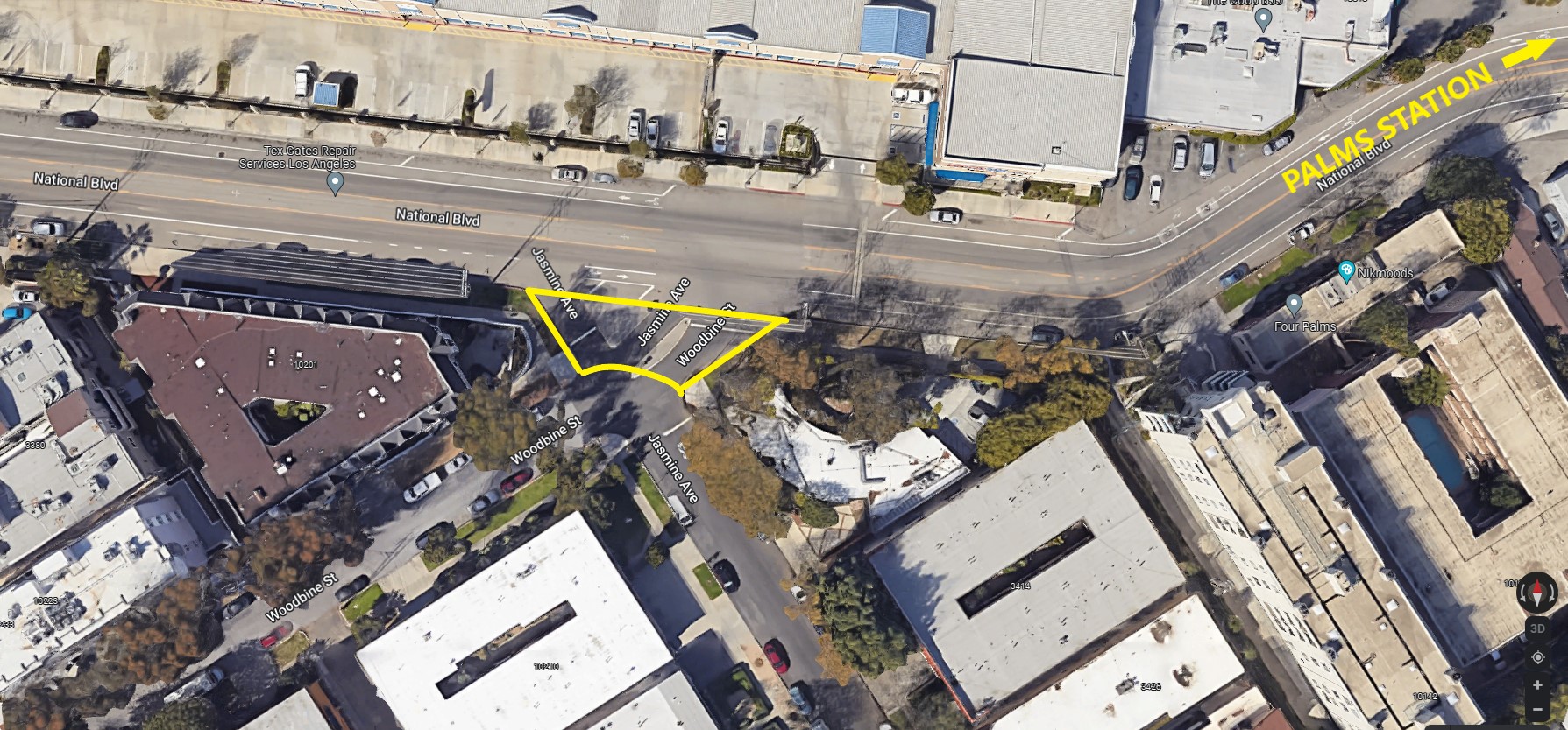
- Woodbine Street/Jasmine Avenue – Simplify the Woodbine/Jasmine intersection (perhaps to just a right angle), allowing for only pedestrians and cyclists to access National, a block west of Palms Station.
Many additional low-stress FLM connections are listed in the Metro plans noted above. Some bike-focused suggestions (that also encourage walking) are listed near the end of this post.
Eliminate slip lanes to prioritize walking
Slip lanes are dangerous for pedestrians. The city should remove them, and reallocate the lane space should be reclaimed for safety and walkability. Some CD5 slip lanes include:
- 10th Street/Gramercy Place/Olympic Boulevard
- Avenue of the Stars/W. Century Drive
- Avenue of the Stars/Olympic Boulevard (onramp)
- Beverly Drive/Pico Boulevard
- National Boulevard/Rose Avenue/Mentone Avenue
- Warner Avenue/Hilgard Avenue
- Wilton Avenue/Wilshire Boulevard (shared with CD13 and CD10, though one slip lane appears to be in CD5)
Add diagonal scramble crossings
CD5 already has a couple of scramble intersections in Westwood. Below are a few more potential locations for additional scrambles, which L.A. tends to site near rail stations and universities:
- Palms Boulevard/Exposition Boulevard/National Boulevard
- Lindbrook Drive at Westwood Boulevard and at Gayley Avenue
- Motor Avenue/National Boulevard
- Westwood Boulevard/Weyburn Avenue
BIKE
Reactivate blocked bikeway projects
Start with four bikeability/walkability projects blocked by previous councilmembers:
- 6th Street – Fairfax Avenue to La Brea Avenue. Former CD4 Councilmember David Ryu killed planned 6th Street road diet safety improvements located a block north of Metro’s under-construction subway. The area was later redistricted from CD4 to CD5. Young Yaroslavsky should work with LADOT to review what had been planned, and work with the community to determine what makes sense, and how to ready this portion of 6th Street to serve as a great first/last mile facility. It may be possible to extend a 2-way protected bikeway around the (minimal driveways) perimeter of much of the museum and/or Park La Brea, making an all-ages bikeway that could connect to the subway station.
- 8th Street – Windsor Boulevard to Wilton Place (ideally further east to Western, including a half-block of CD10). Ryu also quietly blocked plans for the MP2035-approved bike lanes on 8th Street in the eastern part of what is now CD5. The council office should work with LADOT and the community to review, revise if needed, and implement these plans.
- Uplift Melrose. Koretz killed Uplift Melrose, a popular proposal for a more walkable, bikeable Melrose. CD5 should work with the Bureau of Street Services to revive the proposal, and seek to get it funded, probably through the California Active Transportation Program (as city staff proposed two years ago). One quick-build step toward safe walkability/bikeability on Melrose would be to revive plans for small-scale street closures to form mini-parks.
- Westwood Boulevard – Le Conte Avenue to Wilshire Boulevard, and Santa Monica Boulevard to the Expo Line Station and National Boulevard. Koretz repeatedly quashed approved bike lanes on Westwood, both below UCLA and below Santa Monica Boulevard. From UCLA to Wilshire, there’s just enough space for lanes to be added without removing any existing lanes or parking. It would be really good to show Westwood that encouraging bicycling can be easy and painless. The lanes would help workers and students get to the future subway station. And the world won’t end.
Extending the lanes further south, to the Expo Line, would involve more trade-offs. It would entail removing much of the center turn lane, and removing a small percentage of on-street parking. Koretz refused to permit LADOT to study the project and actually quantify the impacts. CD5 should work with the community and city staff to at least study the bikeway, hopefully also to figure out how to minimize any negative impacts, and get the lanes installed.
Implement quick-build protected bike lanes. Council District 5 potential low-hanging fruit (minimal-to-no car lane or parking removal) protected bikeway sites include:
- Hughes Avenue – Venice Boulevard to Washington Boulevard. This would close a one-block gap between bike lanes on both Culver City’s Duquesne Avenue and L.A.’s Venice Boulevard. Given that this block has no on-street parking, protected bike lanes would fit easily. North of Venice Boulevard, Hughes is a very useful street for getting to the E Line Palms Station; as such, bike and walk improvements are needed there, too – though space is tighter there. North of Venice, Hughes could accommodate a one-way northbound bike lane, perhaps paired with southbound sharrows. To really prioritize walking and bicycling, that part of Hughes deserves a treatment that diverts cars while allowing through bike traffic (like L.A. does for rich neighborhoods in CD5). One spot that might work for this would be the offset intersection at Regent Street (which might look like this 4th Street proposal).
- Motor Avenue – Manning Avenue to National Boulevard. This part of Motor has existing unprotected bike lanes, an over-wide underused center turn lane, and some patches where on-street parking is not heavily used. It should be relatively straightforward to narrow much of the center turn lane to free up space to protect bike lanes on both sides. The protection is especially needed (and already approved in MP2035) at the southern end where the street will connect the existing Expo bike path to the future Northvale Gap path. An even better solution would be a two-way protected bikeway on the west side of Motor from the path to National – and – a one-way unprotected bike lane northbound.
- Santa Monica Boulevard – There is plenty of room to add quick-build basic (plastic bollard) protection to existing bike lanes on Santa Monica Boulevard, without removing or even narrowing any lanes allocated to drivers. Streets for All’s Michael Schneider has called for more proper concrete curb protection, which would make the street much safer and still wouldn’t take away driving lanes. Concrete curbs might necessitate seeking outside funding (or redirecting existing funds, like Metro Local Return); this could be part of a bigger reinvention of SMB that includes curb-protected bikeway, and approved bus lanes.
Add conventional (unprotected) bike lanes. Council District 5 potential low-hanging-fruit bike lane streets include:
- Beverwil Drive – Castle Heights Avenue to Beverlywood Street and Rodeo Drive to Holcombe Street.
- Empyrean Way – Century Park East to Avenue of the Stars.
- Galaxy Way – Century Park East to end west of Avenue of the Stars.
- The Grove Drive – Beverly Boulevard to 3rd Street. Councilmember Nithya Raman’s staff had been working on this easy bike lane, before the area was redistricted into CD5.
- Melrose Place – Melrose Avenue to La Cienega Boulevard. This is a wide two lane street that can easily accommodate bike lanes.
- Military Avenue – Exposition Boulevard to National Boulevard. This part of Military has plenty of space. The bikeway would connect to the Expo path, and could be extended further south as a low-stress bike boulevard.
- Overland Avenue – McCune Avenue to Washington Boulevard. From Venice Boulevard to National, Overland bike lanes are approved in MP2035. This two-block stretch is over-wide and would easily accommodate bike lanes, connected to Venice Boulevard bikeway. (More difficult parts of Overland below)
- Rimpau Boulevard – Wilshire Boulevard to Olympic Boulevard. Below Wilshire (all the way to Pico in CD10) Rimpau has space to add bike lanes while keeping (and narrowing) existing lanes.
- Sepulveda Boulevard – Constitution Avenue to Mountaingate Drive (above the Getty shared with CD11). Sepulveda bike lanes, approved in MP2035, are among very few surface street connections between the Westside and the Valley. It is hilly, but as Schneider noted, e-bikes can handle it. Where space is tight, some short bottleneck stretches could have uphill bike lanes and downhill sharrows.
- Sepulveda Boulevard – La Grange Avenue to Pico Boulevard. This stretch, approved in MP2035, could accommodate basic bike lanes.
- Warner Avenue – Wilshire Boulevard to Hilgard Avenue.
- Weyburn Avenue – Veteran Avenue to Weyburn Place (additional below). MP2035 approved basic bike lanes here. Unprotected lanes fit easily; they could be partially protected.
- Wilton Place – San Marino Street to Olympic Boulevard. MP2035 approved bike lanes on Wilton continuing south on Arlington (in CD10). Some of the CD5 portion (Wilshire to Olympic) would need to reconfigure lanes or parking, but this one long block is the easy place to start.
Medium-term bikeways:
The facilities in the two above groups are all easy. The bike facilities below appear feasible, but would require some parking removal and/or some lane reconfiguration (a road diet). They’re clumped into two groups based on rough costs and benefits. These bikeways are all inexpensive, so the costs are political: how likely reconfiguring might trigger a backlash from drivers.
Worthwhile medium-term bikeways that probably wouldn’t trigger a significant backlash:
- 8th Street – Fairfax Avenue to Muirfield Road. This part of 8th is a relatively quiet alternative to its noisy neighbor Wilshire Boulevard; it’s also an important first/last mile connection to the new subway. On 8th, width and parking vary quite a bit, with some bottlenecks where there isn’t quite enough space to easily add continuous bike lanes. There are a dozen-plus blocks where bike lanes appear straightforward, perhaps with some one-way stretches and sharrows at pinch points. Portions of the street might be bike lanes, with some bike boulevard. The intersection and diverter at 8th/Fairfax/Del Valle could be retooled to allow for bikes to go straight through, while cars are still diverted.
- 18th Street – Holt Avenue to La Cienega Boulevard (shared with CD10). Short bikeway would require repurposing unused parts of the center turn lane.
- Airdrome Street – Bagley Avenue to Robertson Boulevard. Project would need narrowing or elimination of the center turn lane.
- Avenue of the Stars – Santa Monica Boulevard to Pico Boulevard. This bikeway is approved in MP2035. The wide streets through Century City have no on-street parking to remove, so basic unprotected bike lanes could be added by narrowing lanes. With the D Line subway station opening soon, a serious Century City protected first/last mile bikeway network is needed (as Schneider has noted).
- Castle Heights Avenue – National Boulevard to Beverwil Drive. Bike lanes could be added by repurposing the center turn lane.
- Century Park East – Santa Monica Boulevard to Olympic. Similar to Avenue of the Stars above.
- Century Park West – Santa Monica Boulevard to Pico Boulevard. Similar to Avenue of the Stars above.
- Constellation Boulevard – Century Park East to Century Park West. This is the street where the Metro subway portal will be, clearly a critically important place for first/last mile connections. The city should act soon to ensure that a bikeway there is part of Metro’s street restoration (unlike Metro/LADOT missed opportunities elsewhere).
- National Boulevard – Overland Avenue to Motor Avenue. This stretch of National was designated for bike lanes in MP2035. To implement these would likely remove a travel lane and/or some parking, which could make the street more-or-less match National Place east of Overland. At the east end, the facility might connect to Motor via Irene Street (perhaps via a protected bikeway along the north side of the street).
- National Boulevard – Motor Avenue to Palms Avenue. This stretch runs along the E Line connecting directly to Palms Station. MP2035 designated a protected bikeway, where the street currently has unprotected bike lanes. It appears that portions of the center turn lane could be eliminated to free up space for a two-way protected bikeway (on the north side of the street) that would serve as a continuation of the all-ages Expo Path.
- National Boulevard – Palms Avenue to Robertson Boulevard. Between Castle Heights Avenue and Robertson, MP2035 approved basic bike lanes, which would likely mean removing some or all of the existing center turn lane. West of Castle Heights, the street widens to make basic bike lanes easier. The facility would connect to Palms Station.
- Ohio Avenue – Sepulveda Boulevard to Purdue Avenue (half in CD11). This street has VA frontage with no parking and few driveways. It appears possible to reconfigure portions of the center turn lane to free up space for a two-way protected bikeway, connecting to the bike path through Westwood Park.
- Palms Boulevard – Exposition/National to the 405 (and to MacLaughlin Avenue in CD11). The CD5 stretch of bikeway is approved in MP2035. Though Palms is wide, squeezing in unprotected bike lanes would mean removing something, likely eliminating much of the existing center turn lane. The best place to start would be on each end. The east end isn’t easy, but it would be a needed first/last mile connection to Palms E Line Station. The west end (from MacLaughlin to near Overland) could be done without removing any car lanes or parking, though it would need to shrink car lane widths to minimums.
- Finish and extend San Vicente Boulevard protected lanes – Cochran Avenue to Burton Way. LADOT announced 1.2 miles of protected bike lanes on San Vicente from Olympic Boulevard to La Brea Avenue, then implemented lanes that stop well short of both of those endpoints. The northwest end of the project is in CD5, where MP2035 shows the bikeway ending from Cochran Avenue all the way up San Vicente onto Burton Way to the Beverly Hills city limit (where Burton narrows from three lanes each way to two – L.A. could match that configuration to free up space). Portions of SVB/Burton have bike lanes, but the city needs to close the gaps by installing, at a minimum, basic bike lanes. As much as possible of this should be protected bike lanes, which may necessitate some parking removal.
Additional SVB upgrades could include: a formal bike/ped crossing at Genesee Avenue now closed to cars and used by cyclists informally (half in CD10), and swapping parking to create curb-protected lanes on SVB’s westbound frontage road between Genesee and Hauser Boulevard (all in CD5). - Tiverton Avenue – Le Conte Avenue to Lindbrook Drive. Tiverton is a relatively wide one-way street that ends at UCLA. A basic bike lane would fit easily. A better solution would allow for contraflow bike traffic.
More difficult medium-term bikeways:
- Beverly Drive – Whitworth Drive to Monte Mar Drive. The upper two blocks of this (Whitworth to Alcott Street) could be done easily. The southern half would take removing/narrowing the center turn lane.
- Beverly Glen Boulevard – Mulholland Drive to Santa Monica Boulevard (possibly to Pico). MP2035 approved bike lanes for this whole stretch. Between Mulholland Drive and Nicada Drive there is enough space for bike lanes. For hilly northern portions below Nicada, an uphill bike lane with downhill sharrows would probably be sufficient. The flatter portions are more useful for cyclists, but not easy. Just below Wilshire space is tight (but an uphill lane could be squeezed in). Between Rochester Avenue and Santa Monica Boulevard, the street widens and appears to have space for basic bike lanes. From Santa Monica Boulevard south, the street remains overwide all the way to where it ends at Pico.
- Hilgard Avenue – Sunset Boulevard to Lindbrook Drive, continuing on Lindbrook Drive to Glendon Avenue. Hilgard is somewhat low volume, with no parking and few driveways along its UCLA frontage. At a minimum, the UCLA side could accommodate a one-way southbound bike lane. It won’t be easy, but with lane/parking reconfiguration, it should be able to accommodate a two-way protected bikeway. South of UCLA, the facility could extend to Glendon.
- Manning Avenue – Motor Avenue to National Boulevard. Narrowing lanes (mainly the center turn lane) could free up space for bike lanes, connecting to existing Motor and future National bike lanes. Where space is tight, an uphill lane could be paired with downhill sharrows.
- Monte Mar Drive – Hillsboro Avenue to Robertson Boulevard. Basic bike lanes would just fit without removing anything. It might be more trouble than it’s worth, but one safety improvement there would be closing the slip lane (at Hillsboro) to cars, but keeping it open to bikes.
- Motor Avenue – Monte Mar Drive to Manning Avenue. Removing/narrowing the center turn lane would make space for these MP2035 approved bike lanes.
- Overland Avenue – McCune Avenue to National Boulevard/Place. This facility is approved in MP2035; the 70-feet wide street is nearly big enough to squeeze in conventional bike lanes, though it would mean narrow car lanes (which LADOT is reluctant to do, other than when adding more car lanes). An alternative would be to repurpose some of the center turn lane and some on-street parking to free up space.
- Pico Boulevard – Avenue of the Stars to Motor Avenue. This bikeway was approved in MP2035, and would be pretty much the only somewhat direct first/last mile connection to the south of the Century City Station. It would require removing one of nine car lanes.
- Robertson Boulevard – Whitworth Drive (Beverly Hills limit) to Robertson Place/Exposition Boulevard (much of this is shared with CD10). This MP2035 facility would need some space (mostly center turn lane) repurposed to fit basic bike lanes.
- Weyburn Avenue – Weyburn Place to Westwood Boulevard. The MP2035 Weyburn lanes would be extended eastward with some reconfiguration of parking and/or travel lanes.
Longer term bikeway projects:
Below are some longer term bikeway projects that would need more analysis, community process, and probably outside funding.
- Improve the Asterisk. Community groups have started to come together to look at ways of making “the Asterisk” (intersection of San Vicente, Olympic and Fairfax) safer, more walkable and bikeable. Support a community study, and work toward solutions.
- Bike Boulevards or Bicycle-Friendly Streets. As noted above, many cities have had success creating Bike Boulevards – calm low-stress (mainly residential) streets shared with folks driving, but prioritizing walking and bicycling. Some CD5 streets that could make sense for bike boulevard treatments:
– 4th Street. The city has been studying this one for more than a decade, but has repeatedly caved to Hancock Park homeowner resistance. The street already sees lots of cyclists and people on foot, so changes don’t need to be extensive, but some sort of walk/bike signals at the worst two intersections (Highland Avenue and Rossmore Avenue) would go a long way.
– 8th Street. Between Beverly Hills and Muirfield Road, 8th Street sees a lot of cyclists who are avoiding more heavily parallel streets. Portions of 8th could fit bike lanes (noted above). The rest would benefit from Bike Boulevard treatments at a few key intersections like Fairfax, Highland and Rimpau.
– Cochran Avenue / Formosa Avenue. Cochran is a useful stress-free north-south bicycling street where 4th Street dead-ends. It is part of a bike-friendly streets grant that CDs 5 and 4 had dragged their heels implementing. Cochran could use some diverters and crossing treatments (perhaps at 8th, Olympic), and the bikeway should continue north, likely briefly on Alta Vista Boulevard, then cutting over to Formosa Avenue.
– Hughes Avenue – see above.
– Kelton Avenue. Kelton Avenue is a low-stress street that connects to Palms Middle School. Further calming, intersection treatments, diverters would make it even more welcoming for walking and biking. The facility could include a spur along Ellenda and Queensland.
– Rosewood Avenue. Neighborhood advocates worked with Koretz to install a diverter at La Brea. Similar treatments at additional intersections (such as Highland, Fairfax and Crescent Heights) could improve Rosewood further.
– Westholme Avenue / Prosser Avenue / Putney Road – The city started this project with a couple of mini-traffic circles on Westholme. The facility could be extended, including on Prosser and Putney, for a low-stress connection to the Expo bikeway.
– Whitworth Drive – Much of this low-volume street is the L.A./Beverly Hills boundary. With a few intersection improvements, it could provide a stress-free connection between Mid-City and the BH area.
- Expo Bike/Walk Path improvements. The city appears to be on the verge of, some day, closing the ten-year-delayed Northvale gap. CD5 should make sure that the project proceeds as soon as possible. There is also some work needed to improve the bikeway gap at Venice Boulevard (Culver City station), including actual curb cuts so cyclists can easily enter the path.
- Metro Bike Share. The Metro Bike Share system currently serves CD5 in Palms and at UCLA. CD5 should ensure that the system expands to serve future Westside subway station first/last mile trips.
- Fix the Santa Monica Boulevard bikeway merge at the Century City/Beverly Hills limit. Both L.A. and Beverly Hills have bike lanes on the over-wide Santa Monica Boulevard. L.A. City’s recent gap closure serves westbound cyclists well. Unfortunately eastbound cyclists don’t quite have a safe connection. The Century City bike lanes put bicyclists onto South Santa Monica Boulevard (called little SMB), where they miss Beverly Hills improvements on the main (big) Santa Monica Boulevard. CD5 should work with Beverly Hills to implement an eastbound SMB connection. The SMB bike lanes already see plenty of cyclists today, and will be an important first/last mile connection when the subway opens in Century City.
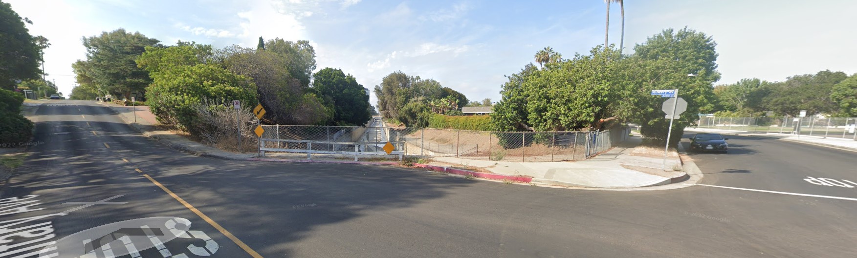
- Sepulveda Channel – Military Avenue to Sepulveda Boulevard. There aren’t a lot of opportunities for new bike paths in CD5, but there is one quarter-mile section of the concrete-lined Sepulveda Channel that could make sense. A creek bike path there would connect the Sepulveda Boulevard bike lanes to the relatively quiet Military Avenue bike route, providing a safe route to Clover Avenue Elementary School. A simple bike path project there could be mainly new gates, new fences, and new asphalt. A more ambitious version could narrow the excess-width of Military to form an entry-point mini-park.
Lastly there are a few over-wide streets that should get basic bike lanes, mainly just because they fit. These are easy/opportunistic, but short and don’t contribute much to a network. These should be installed, but would not be a priority: Cotner Avenue – Pico Boulevard to Olympic Boulevard, Devon Avenue – Ashton Avenue to Beverly Glen, Doheny Drive – Burton Way to Beverly Hills limit (near Beverly Boulevard), Mulholland Drive – Sepulveda Place to Longbow Drive, and Beverly Glen Boulevard to Benedict Canyon Drive (both shared with CD4), Strathmore Drive – Hilgard Avenue to Warner Avenue, and Vista Street – Willoughby Avenue to West Hollywood Limit (above Romaine Street).

Streetsblog has migrated to a new comment system. New commenters can register directly in the comments section of any article. Returning commenters: your previous comments and display name have been preserved, but you'll need to reclaim your account by clicking "Forgot your password?" on the sign-in form, entering your email, and following the verification link to set a new password — this is required because passwords could not be carried over during the migration. For questions, contact tips@streetsblog.org.