Some Actionable Transportation Ideas for L.A. City Councilmember-Elect Eunisses Hernandez
In the June primary election, L.A. City Councilmember-elect Eunisses Hernandez unseated incumbent Gil Cedillo. Hernandez ran well to the left of somewhat left-leaning Cedillo, who is now embroiled in scandal. Hernandez’ campaign centered far-reaching fundamental reforms to L.A. policing and public safety, including “ending mass incarceration and moving money into systems of care” by decriminalizing poverty, expanding mental health support, protecting immigrant communities, and much more.
Hernandez also pledged, as part of a far-reaching environmental justice and environmental agenda, “to redesign the way we get around” with an emphasis on improving conditions for public transit riders, pedestrians, and cyclists. She pledged “to increase our investment in public transportation and street safety,” connecting this with Vision Zero and remedying disproportionate impacts to neighborhoods already suffering from “environmental racism, displacement in the name of development, traffic deaths, and other results of our failure to invest in a more livable city.” She promised to facilitate community-driven processes where residents are actively engaged in shaping the city’s infrastructure, development, planning, housing, parks, safe roads, and transit. (Quotes are from Hernandez’ campaign website.)
Specific to transit, walking and bicycling, Hernandez pledged to:
- “Launch a community review of [CD1’s] dangerous intersections and advocate for redesigning the most impacted areas.”
- “Work with transit advocates… to review planning bike lane installation… for safe transportation options in District 1.”
- “Close off major streets to build walking plazas where business patronage creates neighborhoods… where residents have to travel less for the things they need.”
Her approach is refreshing, and contrasts greatly to that of her predecessor.
While there is a lot that councilmembers can do to influence citywide policies, budgets, and programs, their biggest influence on mobility tends to be the control they exert over the streets in their own district. While Streetsblog expects that Hernandez will have positive impacts on many citywide issues, this post focuses on potential bus, walk, and bike projects located in CD1. Streetsblog checked in with a few L.A. transportation advocates and took a long look at Hernandez’ district to come up with a list of ideas on how the new councilmember might implement her transportation vision.
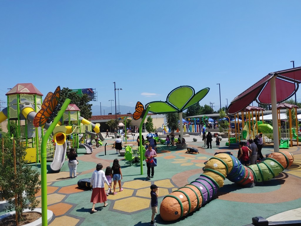
Just where is Hernandez’ CD1? Note that district one was created by a legal challenge back in the 1980s. After being sued, the city had to redraw exclusionary redistricting maps in order to establish a Latino seat on the then nearly all white City Council. CD1 remains Latino majority, with many population-dense low-income communities of color close to downtown L.A. As such, the district has very high levels of transit ridership and walking, and plenty of bicycling too.
Hernandez’s District 1 includes core city neighborhoods west and north of downtown. West of downtown, CD1 communities include Westlake/MacArthur Park, Pico Union, and portions of Koreatown and University Park. North of downtown, it includes Angelino Heights, Chinatown, Elysian Park, Solano Canyon, and much of Echo Park. Northeast L.A. communities in CD1 include Cypress Park, Lincoln Heights, Mount Washington, and much of Highland Park and Glassell Park.
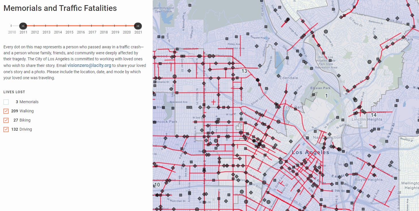
As Hernandez has noted, Council District 1 – and low-income communities of color in general – endure higher rates of traffic deaths and serious injuries, compared to less central parts of the city. In CD1, pedestrians deaths are overrepresented; citywide traffic violence kills Black and Latino pedestrians at higher rates. Significant clusters of CD1 traffic fatalities are seen in MacArthur Park and Pico-Union, the most walked parts of the district. The district has lots of streets on the city’s High-Injury Network (HIN – the six percent of city streets that account for 70 percent of deaths and severe injuries for people walking). Many HIN streets are located just west of downtown (MacArthur Park, Pico-Union, Koreatown), with more in Chinatown, Lincoln Heights, and N. Figueroa and San Fernando Road in Northeast L.A.
What follows is a long list of potential CD1 transit, walk, and bike projects. Some of these are easy, almost trivial. Some are more ambitious, and more likely to upset some folks used to drivers being the city’s top priority. As Hernandez has stressed, it is important that projects be vetted through inclusive community-driven processes that engage residents.
BUS
Install new bus lanes, starting with high ridership lines.
As a central district, CD1 streets carries lots of bus riders on about 40 different transit lines, mainly Metro (30+ bus lines, plus B/D and L rail lines) plus LADOT DASH and Commuter Express. This makes CD1 uniquely situated to implement bus-only lanes that greatly benefit large numbers of transit riders.
In CD1, the highest ridership transit lines (July 2022 weekday ridership shown) are: Metro B/D Line (68,859), Vermont Avenue (lines 204/754: 27,575), Wilshire Boulevard (20/720: 19,317), Sunset Boulevard/Santa Monica Boulevard (2: 19,106), 6th Street (18: 17,900), Metro L Line (16,647), 3rd Street (16: 17,900), Sunset/Alvarado Street (4: 15,874), 7th Street (51: 15,399), and Venice Boulevard (33: 13,008).
Adding new bus lanes for any significant distance will require removing something – generally on-street parking or a driving lane. Though nearly any street where buses go would benefit from bus lanes, in CD1 there are two main types of streets that make the most sense to prioritize for transit improvements, due to their capacity to offer the most benefit for the largest numbers of riders:
- Streets where several bus routes converge (called “trunks”) near downtown. In CD1, these include:
- 6th Street – from Valencia Street to the 110 Freeway. Just east of MacArthur Park, Sixth Street carries its own line 18, Wilshire buses (20 and 720), briefly the 3rd Street bus (16), and the Pico Union Echo Park DASH. Through downtown, most of these lines utilize the 5th/6th bus lane couplet that opened in 2020. It would be fairly straightforward, and highly beneficial, to extend that couplet up out of downtown into Westlake/MacArthur Park. The westbound lane might utilize a queue jumper (at Whitmer Street) to transition to running in the center of 6th for one block, to allow for a faster and easier left turn on to Valencia. The city’s Mobility Plan approved bus lanes on this portion of 6th Street, as well as Valencia (see below).
- Hill Street and Broadway – through Chinatown. Hill carries several bus lines (81, 90, 94, and 96, plus LADOT Commuter Express 419); individually none of these are high ridership lines, but together they carry plenty of people. As Hill Street serves as a de facto Civic Center on/off-ramp for the 110 Freeway, prying away driving/space space to benefit transit riders won’t be easy. But perhaps some on-street parking (possibly at peak hours – similar to the Alvarado bus lane) could give way to bus lanes. The city’s Mobility Plan approved bus-only lanes on nearby Broadway, which now carries fewer riders than Hill with just Metro line 45, DASH B, and Commuter Express 409. If both of these streets’ bus lanes are not straightforwardly feasible right away, it could make sense to install one-direction lanes.
- High ridership CD1 bus routes. These are mostly east-west through the most population dense southern CD1 neighborhoods of Pico-Union and MacArthur Park. Quick-build opportunistic bus lanes would probably start with strategic segments where buses enter/leave downtown. There are a lot of streets to choose from in this area (listed in ridership order, showing July 2022 weekday ridership):
- 6th Street (line 18: 17,900 daily riders). Though the Mobility Plan only approved bus lanes from downtown to Valencia (see above), there is a good case for extending 6th Street bus lanes further west – perhaps to Alvarado, or Lafayette Park (the end of CD1), or Vermont Avenue (in CD10).
- 3rd Street (line 16: 15,927). Installing bus-only lanes on Third is probably easiest in stretches with no (or very little) on-street parking, including from the 110 to Alvarado Street, and perhaps from Lafayette Park Place to Vermont Avenue (partially shared with CD13 and CD10).
- 7th Street (line 51: 15,399). Seventh already underwent a road diet to make room for bike lanes, so also adding bus lanes would require on-street parking removal. The first place to start adding bus lanes would probably be relatively wide blocks closest to downtown: from Figueroa Street to Witmer Street or Lucas Avenue. That could include adding protection to the bike lanes.
- Venice Boulevard (line 33: 13,008). For the full extent in CD1 (1.6 miles from the 110 to Normandie Avenue), the Mobility Plan designated Venice Boulevard for both bus lanes and bike lanes. Implementing these approved facilities requires removing one or more car lanes and/or on-street parking.
- From there the ridership gets lower: 8th Street (line 66: 10,520), Beverly Boulevard/1st Street (line 14/37: 9,227), Pico Boulevard (line 30: 8,513), Olympic Boulevard (line 28: 8,054), Temple Street (line 10/48: 5,658), and Washington (line 35/38: 4,026). All these streets would benefit from bus lanes, but higher ridership lines would make sense to prioritize initially.
Lastly, a couple more bus improvements that didn’t fit those two groups:
- Vermont Avenue. Vermont is currently Metro’s highest ridership bus corridor; CD1 includes a mile-long portion of Vermont from Olympic Boulevard to the 10 Freeway. Metro has a longstanding, painfully slow moving effort to build Bus Rapid Transit (and ultimately a subway) there. CD1 should get behind these Metro efforts, pushing for needed improvements on the ground as soon as possible. Perhaps CD1’s stretch of Vermont could be some sort of quick-build demonstration project showcasing solutions that might later be extended further along Vermont.
- Valencia Street – between 6th and Wilshire. Wilshire buses travel this short (two-block) stretch of Valencia to go in and out of downtown via 6th Street. Valencia is a relatively narrow short street that dead ends on both ends. It is a pinch point that slows buses down as they spend time making turns at either end, often waiting behind cars also waiting to turn. Streetsblog doesn’t have a finalized design for this street (which has a few driveways and on-street parking), but it looks feasible to add some sort of bus-only features – perhaps turn pockets on to and off of Valencia, somewhat similar to the Aliso Street bus-only turn pocket in downtown L.A. Dedicated queue-jumper signals at each end could be triggered by buses. It may also be possible to reduce car traffic on Valencia, perhaps by closing a portion of the street to private vehicles, or limiting private vehicles to driving to one-way while allowing two-way bus traffic.
- Generally, bus lines in the Northeast Los Angeles portions of CD1 don’t carry quite as high ridership as those lines in the downtown-adjacent central part of the district, so Streetsblog has not focused much on bus improvements in NELA. CD1’s highest ridership lines there are Cypress Avenue (line 251: 11,926), N. Broadway (line 45: 11,405), N Figueroa Street (line 81: 7,952), and San Fernando Road (line 94: 6,246 and line 90: 3,856). Here are a couple possible bus projects in that area:
- Adding some sort of queue jumpers, dedicated lanes and/or turn lanes in the N. Figueroa/Avenue 26 area where lines 251, 81, 90, and 94 converge. The most beneficial improvements there might be one-way bus lanes following the route of the 251 bus.
- Adding bus lanes on portions of over-wide streets, perhaps Cypress Avenue/Eagle Rock Boulevard and/or San Fernando Road.
WALK
CD1 has some of the most heavily walked neighborhoods in the city. Parts of MacArthur Park and Pico Union see more pedestrians than many downtown streets.
The most fundamental need for walkable places is sidewalks, and the city’s legally mandated sidewalk repair program, “Safe Sidewalks,” needs councilmembers committed to making it more effective, responsive, and transparent. CD1 should work with communities to identify and complete needed sidewalk repairs – with a strong emphasis on the needs of folks with disabilities.
A second citywide initiative (that Hernandez already supports) highly applicable to CD1 is to encourage street vending. Vendors contribute to walkable safe diverse communities. Work with the L.A. Street Vendor Campaign (LASVC) to support vendors in CD1 and throughout the city. Eliminate vendor prohibition zones. As Hernandez’ platform states, walking plazas (see below) should support vending. Similarly, vendors should also activate Metro stations – potentially including Metro parking lots at MacArthur Park Station, Lincoln/Cypress, and Heritage Square; these lots need taco trucks. The Alliance for Community Transit has pushed for (and demonstrated) greater activation of Metro stations; though Metro resists it (outside of some pilots), street vending should be one aspect of a community approach to Metro public safety.
Below are potential places to create walk plazas, initially at opportunistic leftover spaces:
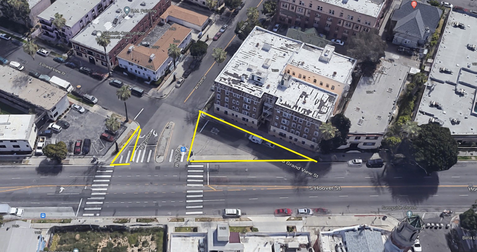
- Triangular spaces along Hoover Street. Hoover is where the offset downtown grid meets the main city grid. Where downtown streets intersect with Hoover, there are many leftover triangle spaces, and many places where excess space has been given over to drivers. It is possible to close off these short unneeded street spaces to form triangular pedestrian plazas. Spaces conducive to this include: Hoover/Union Street (expand triangle park), Hoover/Burlington Avenue, Hoover/Alvarado Street, Hoover/Lake Street (get cars out to expand the modest existing plaza), Hoover/Grand View Street, Hoover/Carondelet Street, Hoover/Park View Street, Hoover/Rampart Boulevard, Hoover/La Fayette Park Place, Hoover/Occidental Boulevard, and Hoover/Reno Street. (Hoover from Olympic south is on the HIN.)
- Slip lanes. There aren’t tons of right turn slip lanes in CD1, but similar to the Hoover triangles, existing slip lanes (dangerous for pedestrians) could be reclaimed for walking and vending. CD1 slip lanes include: northwest corner of Hoover and Washington Boulevard, and the southeast corner of York Boulevard/N. Figueroa Street (shared with CD14).
- Other CD1 leftover triangles that might be converted to plazas: 10th Street/Olympic Boulevard, Amador Street/Jarvis Street, Beaudry Avenue/Sunset Boulevard, Bellevue Avenue at Marion Park, 8th Street/Valencia Avenue (expand existing triangle park), Alice Street/Cypress Avenue, Everett Street/Sunset Boulevard, Lilac Terrace/Sunset Boulevard, Main Street/Alameda Street (shared with CD14), Solano Avenue/Jarvis Street, Union Avenue/Pico Boulevard, Union Avenue/Venice Boulevard triangle, Verdugo Road (south)/Eagle Rock Boulevard, and Workman Street/Pasadena Avenue/Avenue 28.
The above triangle spaces are opportunistic; they would have somewhat small positive impacts: safer walking with minimal detraction from driving/parking. But CD1 can go bigger; Hernandez brought up “closing off major streets.” Below are are more locations for pedestrianizing streets – mainly to encourage and support walking in places where lots of folks already walk. Note that these potential street closures are mainly streets next to major streets, avoiding closing streets with bus lines, and avoiding closing driveways. Also, these major closures need major community processes. Nonetheless, here are some potential streets to close off to car traffic:
- 23rd Street – Union Avenue to Hoover Street
- Avenue 56 – N. Figueroa Street to alley (northwest of N. Figueroa)
- Avenue 59 – N. Figueroa Street to alley (northwest of N. Figueroa)
- Bonnie Brae Street – 6th Street to 505 Bonnie Brae driveway
- Bruno Street (unnamed – next to Chinatown Station) – Alameda Street to Spring Street
- Coronado Street – 7th Street to Golden Age Park (or possibly to 8th Street, if parking access can be limited to alleys)
- James Wood Boulevard* – Park View to Grand View and/or Alvarado Street to alley to Lake Street
- New Hampshire Avenue – Pico Boulevard to alley (south of Pico)
- Ord Street – Broadway to New High Street, and/or New High Street to Spring Street
- Toberman Street – 35th Street to Adams Boulevard
- Westlake Avenue – 7th Street to 730 Westlake Avenue
- Valencia Street – 7th Street to alley (near Cambria Street)
- Valencia Street – Connecticut Street to 11th Street
(*This part of James Wood is on the HIN, all others listed above are immediately HIN-adjacent.)
Lastly, CD1 already has a few scramble intersections that improve safety in highly walked areas. Here are a few more potential location for additional scrambles, all on the HIN, many near transit stations:
- 6th Street/Westlake Avenue
- 7th Street/Union Avenue
- Alvarado Street/8th Street
- Broadway/College Street
- Broadway/Daly Street
- Broadway/Ord Street
- Five Points (Avenue 26/Daly Street/Pasadena Avenue). This complex high-injury intersection deserves a thorough planning process for more than just scramble crossing.
- N. Figueroa Street/Avenue 57 (and/or Avenue 58)
- Pico Boulevard/Union Avenue
BIKE
There is a very long backlog of basic CD1 bikeway projects that were shelved due to the stridently anti-bike stance of former City Councilmember Gil Cedillo. Cedillo outright canceled several projects, and also quietly kept the city from doing basic low-hanging fruit bike lane projects during routine street repaving.
Install relatively easy short term bikeways
Start with four bikeway projects blocked by Cedillo:
- Avenue 19 – San Fernando Road to (at least) near Humboldt Street. LADOT announced upcoming Avenue 19 bike lanes back in 2019, which would have closed a gap bringing the L.A. River bikeway into downtown, then… crickets. This week, the city again announced this bikeway would be implemented, this time by July 2023 as part of the new BLAST program. Since that area’s roads were reconfigured by bridge construction nearly a decade ago, there is plenty of space to add protected bike lanes in what is now a striped-off shoulder. Ideally though, with a supportive councilmember, the site could get an even better treatment. Avenue 19 is split into two ~24-foot wide roadways carrying just one lane each. Ideally, two-way car traffic could be on one side of Avenue 19, with the other side dedicated to bicycling and walking. That facility should also extend southeast (ideally, as approved in the Mobility Plan, to Spring Street – though that would require removing some parking) as a two-way protected bikeway.
- N. Figueroa Street – Avenue 50 to York Boulevard. In 2014, Cedillo canceled LADOT plans to remove a car lane to add buffered bike lanes on N. Figueroa through the center of Highland Park. While it may be possible to just dig up the old LADOT plans, here, too, it might be worth looking into a better design: protected bike lanes, possibly a two-way protected facility on one side of the street.
- N. Spring Street/Wilhardt Street – L.A. State Historic Park to Avenue 19. The city recently installed the Spring Street Bridge bike lanes that Cedillo blocked for four years. Unfortunately, the project, which was justified as connecting cyclists to the LASHP, left the new lanes one block short of the park. At a minimum, the city needs to install a real bikeway (not just sharrows) on the one block of Wilhardt Street between Spring and the park. Ideally this would be a two-way protected bikeway. That all-ages two-way facility could be continued across the bridge to connect with one on Avenue 19, effectively bringing the river path into downtown.
- Temple Street – Beaudry Avenue to at least Alvarado Street. In 2018, Cedillo colluded with Councilmember Mitch O’Farrell to kill planned Vision Zero safety improvements on Temple Street. Find the plans, or upgrade to a better protected design, perhaps two-way protected.
Implement quick-build protected bike lanes. Council District 1 potential low-hanging fruit (minimal-to-no car lane or parking removal) protected bikeway sites include:
- Bellevue Avenue/Marion Avenue – Bellevue from Edgeware Road to Sunset, and Marion from Kensington Street to Sunset. Adding parking-protected bike lanes would effectively narrow this Angelino Heights street plagued by dangerous street racing. The facility would extend new Bellevue Avenue lanes installed last June (which could be upgraded to protected, by shrinking the unneeded center turn lane and removing a few parking spaces).
- Cypress Avenue – Arroyo Seco Avenue to Idell Street. Existing bike lanes could easily be converted into a two-way protected bikeway alongside Nightingale Middle School.
- Darwin Avenue – Avenue 17 to Avenue 21, and Daly Street to Thomas Street (Griffin to Thomas is in CD14). Darwin is an overwide residential street; east of Daly it has conventional bike lanes. There is just enough space to narrow car lanes to make a two-way parking-projected bikeway, probably along the north side where it would connect to Griffin Avenue Elementary School.
- Griffin Avenue – Altura Street to at least N. Main Street. Existing buffered bike lanes could easily be upgraded to parking-protected lanes on this over-wide residential street section – all the way to Mission Road. Portions of the street are shared with CD14.
- Hoover Street – Washington Boulevard to 22nd Street (partially shared with CD8). Add protection where existing bike lanes cross under the 10 Freeway.
- La Fayette Park Place – 3rd Street to 7th Street. This is an over-wide street with some stretches of diagonal parking on one side. A one or two-way protected bikeway could be tucked between the diagonal parking and the curb, similar to Eldridge Avenue in Sylmar. La Fayette Park Place jogs at 6th, where it might work to connect the two ends with a protected two-way facility in front of the park. (The bikeway could also continue north a couple more blocks to Beverly, in CD13.)
- Pasadena Avenue – N. Figueroa to Avenue 35. This over-wide stretch could easily accommodate a two-way protected bikeway, along its west side, where there is neither parking nor driveways. There is probably room to also include a one-way unprotected northbound lane on its east side (similar to Ocean Boulevard). The bikeway would serve first/last mile travel to Heritage Square Station (to get to the station, it could include a one-block spur on French Street).
- N. Spring Street/Alameda Street – State Historic Park to Ord Street. The existing walk/bike path in front of LASHP could be extended southward as an on-street two-way protected bike way, as approved in the Mobility Plan. These could run along Spring to the Chinatown Station, and continue south along Alameda Street to the end of CD1 (Ord Street) and in to Union Station (in CD14).
- Toberman Street – Venice Boulevard to 18th Street. This part of Toberman is an 80-foot wide two-lane residential street. Even with diagonal parking, the street has space to add a two-way parking-protected bikeway, including in front of Toberman Park.
Add more conventional (unprotected) bike lanes. Council District 1 potential low-hanging-fruit bike lane streets include:
- 1st Street – Bixel Street to Beaudry Avenue. This would extend existing First Street bike lanes coming out of downtown. This facility might be extended west into CD13 (perhaps up the hill to at least Belmont Avenue), with some reconfiguring of the little-used center turn lane and, at pinch points, uphill bike lane and downhill sharrows.
- 3rd Street – Coronado Street to Westmoreland Avenue (shared with CD13). This no-parking stretch of Third would just fit basic unprotected bike lanes (could be in conjunction with bus-only lanes).
- 4th Street – Hoover Street to Commonwealth Street, at least. Fourth is already a heavily bicycled route (at one time informally called 4th Street Bike Boulevard) because it has relatively low car traffic, allowing cyclists to avoid nearby arterials. One block, Hoover to Commonwealth, is easily wide enough for bike lanes. The next couple blocks westward, behind the old Shriners Hospital to Shatto Park, could potentially lose their northside on-street parking to extend the bike lanes to Shatto Place (in CD1) or one more block to Vermont Avenue (in CD10).
- 5th Street – Commonwealth to Shatto Place (shared with CD10). This part of Fifth is a three-block-long overwide residential street. Conventional bike lanes would fit easily; an optimal treatment would probably be a parking-protected bikeway on one side, with a one-way unprotected bike lane in the other direction (like Ocean Boulevard).
- 18th Street – Burlington Avenue to Toberman Street.
- 23rd Street – Hoover Street to Figueroa Street. Twenty-third narrows east of Estrella Avenue, but basic bike lanes fit with no removal of parking or travel lanes.
- Alpine Street – N. Spring Street to N. Main Street. These two blocks are the very easy part of the Alpine/Vignes bikeway approved in the Mobility Plan. (Lanes should continue southeast into CD14 on Vignes Street to Ramirez Street.)
- Alvarado Street – Pico Boulevard to 8th Street. The Mobility Plan approved bike lanes for all of Alvarado below Glendale Boulevard; this is the easiest place to start that project.
- Avenue 33 – Verdugo Road to Bushwick Street. The 60′-wide two-lane portion (Eagle Rock Boulevard to Bushwick) would very easily fit conventional bike lanes. It could make sense to go even further and perhaps put in a two-way protected bikeway on one side, and a one-way unprotected lane on the other side. (If funding wasn’t an issue, perhaps a 25+-foot wide landscaped bike/walk rambla could be put down the middle?) Though the road narrows east of ERB, basic bike lanes could extend east to Verdugo Road. East of Verdugo (to Moss Avenue) there is space for an uphill bike lane with downhill sharrows.
- Avenue 42 – Eagle Rock Boulevard to York Boulevard. This overwide stretch of Avenue 42 would easily fit bike lanes connecting to bikeways at each end.
- Avenue 50 – Malta Street to N. Figueroa Street. On this stretch of the HIN, there is space to extend the existing Avenue 50 bike lanes to Figueroa. Ideally, this stretch (and pretty much all of the existing Avenue 50 lanes) should be a two-way parking-protected bikeway.
- Avenue 59 – N. Figueroa to Echo Street.
- Avenue 60 – Hayes Avenue to Benner Street. This could be extended to N. Figueroa as an uphill bike lane with downhill sharrows.
- Beacon Avenue – 7th Street to 11th Street.
- Beaudry Avenue – Temple Street to 6th Street. The Mobility Plan approved bike lanes on the north end of Beaudry along Roybal High School where the street is overly wide. The bikeway could extend south, with an uphill lane and downhill sharrows at a narrow part. Then bike lanes could resume where Beaudry widens, south of 4th Street.
- Bonnie Brae Street – 3rd Street to Beverly Boulevard.
- Boylston Street – 4th Street to Miramar Street.
- N. Broadway – Solano Avenue to N. Spring Street. This wide stretch with no parking would accommodate basic bike lanes.
- Chavez Ravine Place – College Street to Stadium Way.
- Commonwealth Street – 3rd Street to 5th Street. Commonwealth is an overly wide residential HIN street, extra-wide south of Geneva Street. Conventional bike lanes would fit easily; below Geneva, protected lanes might make more sense. (The bike lanes could continue south from 5th to 6th easily in CD10, and probably also to Wilshire. They could extend north to Beverly Boulevard in CD13, though this would require removing a little-used center turn lane.)
- Echo Park Avenue – Montana Street to Bellevue (shared with CD13). There is just enough space for basic bike lanes. An even better treatment (that would involve some parking removal) would be a two-way protected bikeway, especially along the park.
- Figueroa Place – 23rd Street to Figueroa Street. This would create a connection from 23rd onto southbound MyFigueroa. There may be enough space to make this parking-protected.
- N. Figueroa Street – Marmion Way/Pasadena Avenue to Avenue 50. Similar to the bike lane stretch immediately south, this HIN street can accommodate basic bike lanes – with at least some protected stretches (as approved in the Mobility Plan).
- Grand Avenue – Sunset to the 101 Freeway. The facility could extend north of Sunset as one-way uphill, and south of the 110 (in CD14) to meet the existing Grand bike lane at 5th.
- Griffin Avenue/Avenue 52 – Griffin from Avenue 33 to Avenue 52, and Avenue 52 from Montecito Heights Rec Center Park to the residential area where the street narrows. Bike lanes fit easily north of Avenue 39. South of Avenue 39, Griffin narrows somewhat, but appears to have just enough space to add minimum bike lanes (perhaps a couple of parking spaces might be lost at curves).
- Jeffries Avenue – Avenue 26 to Isabel Street. This overwide residential street easily accommodate conventional (maybe protected) lanes, connecting to Nightingale school and the River Center.
- Laveta Terrace – Kensington Road to Laguna Avenue. This wide residential two block stretch easily fits bike lanes, and could be extended one more block to Sunset via a one-way uphill bike lane.
- Pasadena Avenue – North Broadway to Avenue 23. Basic bike lanes would fit, as approved in the Mobility Plan.
- Pico Boulevard – 110 Freeway to Toberman Street. The Mobility Plan approved bike lanes for Pico west of downtown; this is the easiest part of that project.
- Piedmont Avenue – Avenue 58 to Avenue 61. There is plenty of space for lanes, which could be a two-way parking-protected bikeway, which might also extend north another long block, along the park and library.
- Shatto Place – (shared with CD10) bike lanes could connect 4th and 5th Streets to Metro Wilshire/Vermont Station.
- Stadium Way – Bishop’s Road to Curtis Street.
- Washington Boulevard – Oak Street to Union Street. The Mobility Plan approved bike lanes for Washington west of downtown; this is the easiest part of that project.
- Westmoreland Avenue – between Pico and Olympic. Bike lanes would easily fit from Pico to Olympic. These could be extended south to 17th Place, though this might require some lane or parking reconfiguration.
Medium-term bikeways:
The above facilities are easy, basic. The bike facilities below appear feasible, but would require some lane reconfiguration (a road diet), or parking removal.
- 2nd Street – Lucas Street to Figueroa (half a block in CD14). Removing some little-used parking (on the south side) could free up space to install a two-way protected bikeway connecting into downtown – as approved in the city Mobility Plan.
- 7th Street – Hoover Street to Alvarado Street, at least. Some portions of the existing 7th Street bike lanes could be upgraded to parking protected lanes, possibly in conjunction with bus-only lanes. Wider stretches – along MacArthur Park and near downtown (probably Figueroa to Lucas Avenue) – could be where to start.
- 11th Street – Vermont to Hoover Street. This over-wide residential street (on the HIN) is already somewhat traffic-calmed via a street closure at Hoover. It recently received too-modest safe routes to school upgrades connected to Leo Politi Elementary School. The width appears to be sufficient for a two-way parking-protected bikeway. The east end could use a more permanent, more mini-park-like street closure, with a possible connection eastward to the nearby 11th Street bike lanes (might be a ped/bike signal connecting to a short two-way protected bikeway along the east side of Hoover).
- Artesian Place – at Humboldt Street. Increase connectivity by adding a gap to permit cyclists and pedestrians to get through the recent street closure.
- Boylston Street – Temple Street to Colton Street. This over-wide street has diagonal parking and a little-used center turn lane. It could be reconfigured to accommodate bike lanes, perhaps a two-way protected bikeway (along Roybal High School).
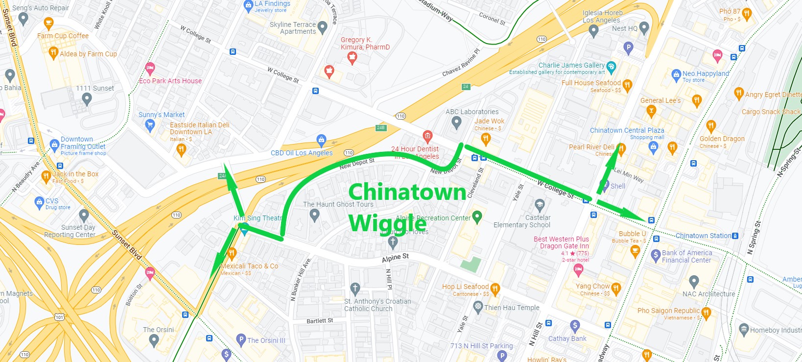
- Chinatown Wiggle. To avoid hills through Chinatown, many cyclists ride along Alpine Street/New Depot Street/College Street. While it is already a useful bike route, the city could improve it. At a minimum, the city could add signage/sharrows. Possible upgrades:
– Alpine Street. Remove parking from one side of one block on Alpine (from Figueroa to New Depot) to add a bikeway – could be conventional bike lanes, or possibly two-way protected.
– New Depot Street. The west end of New Depot is somewhat narrow; that portion would probably only get sharrows. The east end of the street is a little wider and would fit an uphill lane with downhill sharrows.
– College Street. College is somewhat difficult to reconfigure, as it is a relatively small street with parking and peak-hour parking restrictions. It may be possible to do a road diet, restore one-side peak hour parking, and add a bikeway (ideally to Chinatown Station).
– Wiggle approach: Add new bike lanes on Alpine Street (including bridge over 110), Figueroa Terrace, Bartlett Street, and Beaudry- to connect to Sunset. The existing bikeway on overly wide Figueroa Street from Chavez to Alpine (and probably south of Chavez into CD14) could be upgraded to protected, possibly 2-way protected northbound and one-way unprotected southbound.
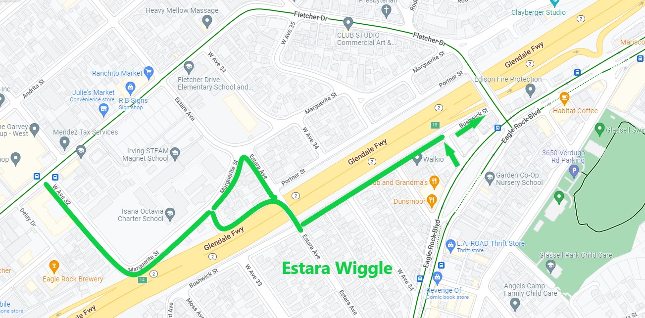
- Estara Avenue Wiggle (shared with CD13). To avoid hills and traffic on Fletcher, some cyclists use a quieter flatter route (which Streetsblog is here naming the Estara Wiggle) on Avenue 32, Marguerite Street, Avenue 33, the alley along the 2, Estara Avenue, Bushwick Street, and Crestmoore Place. The route is already useful, and could be made more so by possible upgrades. At a minimum, the city could add signage/sharrows. From there it may be possible to add bike lanes on parts of Avenue 33, Estara, Crestmoore, and Bushwick.
- James Wood Boulevard. Between downtown and Hoover, with some trimming of the center turn lane and some parking loss, this High Injury Network street could have bike lanes (perhaps protected), which could be in conjunction with street closure above.
- N. Main Street – from College Street to Gibbons Street. Much of this part of Main Street (approved for bike lanes in the Mobility Plan) is overly wide, with no parking areas between Sotello Street and Gibbons Street. Hence it could easily accommodate bike lanes. To make this facility more useful, it should extend south to connect to Chinatown Station (or, in CD14, Alameda) and north – potentially to Daly Street or Griffin Avenue (east of the river, Main is shared with CD14).
- Marmion Way – from N. Figueroa to Monte Vista Street. This stretch along the Metro L (Gold) Line has some areas (south of Museum Drive) where parking is permitted, but sparsely used. If parking is retained, some of the facility might be uphill lane with downhill sharrows. North of Museum, there is sufficient space for bike lanes, possibly protected. The bikeway could connect to the closed slip lane at Greayers Oak Park.
- Normandie Avenue – 10 Freeway to Pico Boulevard (all shared with CD10). From the 10 to Venice Boulevard has sufficient width for basic bike lanes; between Venice and Pico a few parking spaces might need to be repurposed.
- San Fernando Road – 2 Freeway to 110 Freeway. This HIN bikeway was approved in the Mobility Plan. Some of the street (along Taylor Yard) is overwide, and could fit basic bike lanes.
- Sunset4All – Sunset Boulevard from Douglas Street east. CD1 includes a couple long blocks of the proposed Sunset4all two-way protected bikeway, which is primarily in CD13.
- Taylor Yard Bike Bridge approaches. From NELA, connections to the new Taylor Yard bike bridge are hard to find, and are made difficult by having to cross San Fernando Road. Orient cyclists by adding signage, sharrows, and short strategic bike facilities. Connecting communities north of the bridge: add a curb ramp to access the winding path in front of Rio de Los Angeles State Park, direct cyclists to cross San Fernando at Future Street (which could remove one short block of parking to install a protected bikeway between Cypress and San Fernando). For communities east of the bridge, direct cyclists onto Arvia Street (much of which could get a one-way uphill bike lane) and Via Molina. Include signage on Cypress Avenue.
- Verdugo Road – Avenue 30 to Eagle Rock Boulevard. Verdugo is a relatively wide low-traffic street. It appears to be possible to remove the little-used center turn lane, and repurpose the space to add a bikeway (not difficult to just add bike lanes, but it may be possible to do two-way protected on one side).
- Virgil Avenue – 3rd Street to 6th Street. Virgil bike lanes were approved in the Mobility Plan, but will likely require a road diet.
- Westlake Boulevard – 3rd Street to 6th Street. This over-wide HIN street primarily needs to be made safer for walking. It would easily fit an uphill bike lane, which would be a very small improvement. Adding a parking-protected bikeway would more effectively calm traffic, though this would require reconfiguring the little-used center turn lane.
Longer term bikeway projects:
Below are some longer term bikeway projects that need significant funding, and thorough community planning processes.
- Arroyo Seco. The Arroyo Seco has an in-channel bike path that extends from York Boulevard to Montecito Heights Rec Center. In the long run, that facility should connect to the L.A. River at the Arroyo-River confluence. The gap is only two miles, but there is not a lot of right of way to work with. Over a decade ago, an L.A. County effort to extend the Arroyo path fizzled due to several constraints (putting the path on the bank would take out trees, putting it in the channel makes it isolated and harder to maintain). As the city and Metro connect the river bikeway through the confluence, it is time to revisit next steps for an Arroyo path. Similar to the L.A. River path through Lincoln Heights, it may make sense to do an early on-street facility paralleling the Arroyo – possibly on Carlotta Boulevard. Similar to L.A. River revitalization, Arroyo Seco revitalization needs to serve local communities.
- Bike Boulevards or Bicycle-Friendly Streets. Some cities have had success creating Bike Boulevards – relatively calm small streets shared with folks driving, but prioritizing walking and bicycling. L.A. approved these in its Mobility Plan (calling them “bike friendly streets” in the Neighborhood Enhanced Network), but the closest it has come to implementing them has been the underwhelming Slow Streets program. CD1 could work with neighborhoods to create effective Bike Boulevards, that would included diverters (which LADOT uses to calm traffic in well-off neighborhoods). Some streets approved in the plan that could make sense: 4th Street, 12th Street, Bonnie Brae Street, Manitou Avenue, and Workman Street.
- Elysian Park (shared with CD13) bike upgrades. Today, Elysian Park is a fairly difficult place to bicycle or walk, due to wide roads leading to Dodger Stadium, plus the park’s hilly terrain. Nonetheless, it should be possible to free up some space dedicated to driving, and invite people to enjoy the park on foot and on bike – especially kids and their families. Potential upgrades could include:
– Car-free Streets: Similar to (but less than) Griffith Park, Elysian has a few stretches of closed-off park road (Elysian Park Drive west of Grace Simons Lodge) that cyclists and pedestrians use. It could be advantageous to encourage cycling and walking (and reduce car traffic) by closing some other streets to driving; candidates could include portions of Grand View Drive, Angeles Point Road, and maybe more of Elysian Park Drive.
– Chinatown Connection: The city should work with the stadium to create a pedestrian connection to Chinatown, likely via the 110 Freeway pedestrian overcrossing at Yale Street.
– Park bikeways. It may also be possible to add more bikeways in the park. One place for this would be the relatively flat route through the park on Academy Road. It could also make sense to do a protected bikeway along Stadium Way.
– Calming Car Traffic: What would really calm the park would be to block off the cut-through connection between the northern and southern parts of Stadium Way.
Major Elysian Park changes would need a serious respectful community planning process, and would need to be compatible with stadium car traffic. - Los Angeles River revitalization. There are plenty of slowly moving pieces in the region’s efforts to revitalize the L.A. River, including many projects in CD1:
– Metro is currently studying a (Measure M funded for a 2023 groundbreaking) extension the L.A. River bike/walk path to close the gap from NELA to Southeast L.A. County. CD1 can help get that project across the finish line, including ensuring that it connects with neighborhoods. (In the nearer term, see Avenue 19 and Spring Street above for a quicker-build on-street river path connection into Chinatown.)
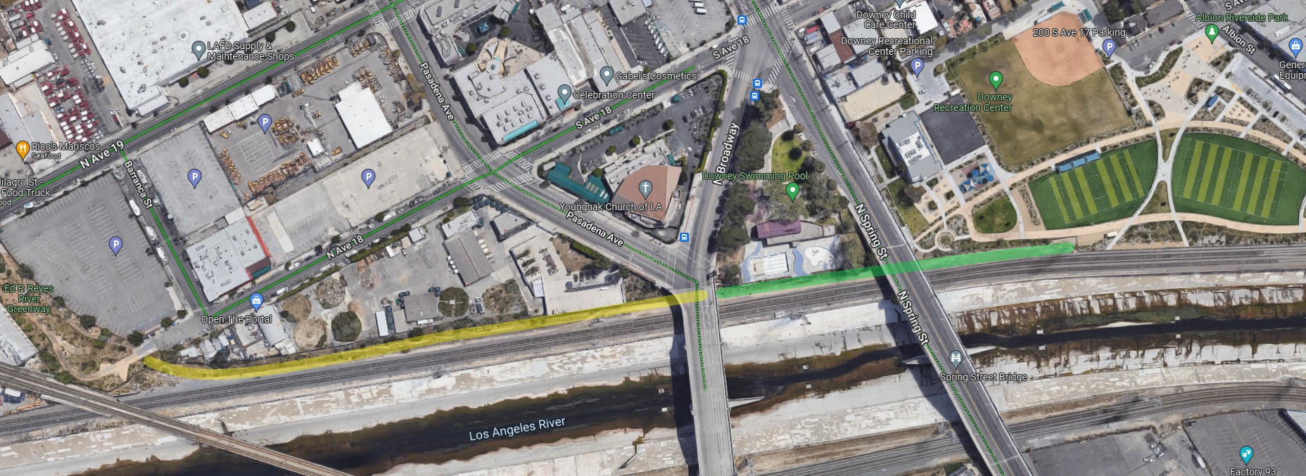
– One CD1 spur on the River bikeway could be on city-owned property along Albion Riverside Park and Downey Swimming Pool. That city property might be combined with a narrow stretch of undeveloped right-of-way (running between the railroad tracks and back fences along Avenue 18, above) to extend a bike/walk path between Albion and the Ed Reyes River Greenway mini-park.
– Midway Yard is located between the L.A. River and Elysian Park. Twenty years ago, when Metro initially developed the Elysian Park adjacent Midway Yard (now called Metro Division 21) for the initial Gold Line, that yard was to have been temporary, with the yard’s functions shifting to a larger yard along the Foothill Gold Line extension in Monrovia. The Monrovia yard opened in 2016, and Metro has shown no signs of leaving the initial temporary site. CD1 should look into the possibilities for the future of Midway, which could connect Elysian Park to the river.
– In addition to the bikeway, the city and county are gradually pursuing river revitalization. Depending on how it is carried out, revitalization could bring much needed green space to low income neighborhoods, or could hasten gentrification. Working with these efforts, CD1 should ensure that community voices are heard, that benefits support communities rather than displace them, and that preserving/building affordable housing is part of river renewal.
Lastly, there are a handful of easy short bike lane projects that are worthwhile, but contribute negligibly to safety or to network connectivity. The city should do these projects during repaving, but they wouldn’t be a priority: 4th Street – Boylston to Bixel; Bernard Street – Broadway to Hill; Hill Street (one-way frontage) – Sunset to Ord; Irvington Place – Avenue 53 to Avenue 54; Loma Drive – Beverly to 3rd; Lucas Avenue – 4th to Emerald; Miramar Street – Beaudry to Boylston; Ocean View Avenue – Lake to Coronado (uphill lane); and Shults Street – Arroyo Drive to Benner.

Streetsblog has migrated to a new comment system. New commenters can register directly in the comments section of any article. Returning commenters: your previous comments and display name have been preserved, but you'll need to reclaim your account by clicking "Forgot your password?" on the sign-in form, entering your email, and following the verification link to set a new password — this is required because passwords could not be carried over during the migration. For questions, contact tips@streetsblog.org.