Metro and L.A. Keep Widening Streets At Transit Stations: Regional Connector Grand Avenue Edition
Metro is spending billions of dollars to expand rail transit in Southern California. Metro’s nearly completed downtown L.A. Regional Connector, a $1.8 billion 1.9-mile light rail subway, is anticipated to open this fall, or maybe early 2023. Construction is so far along that Metro is sharing its plans for how the agency will “restore” streets around some stations.
Below is Metro’s plan for the area around the Grand Avenue Station – located directly behind the Broad Museum and connected to it via a new pedestrian bridge.
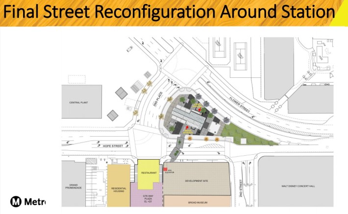
While a lot of Metro’s “civil improvements” around stations (mostly street widening and repaving, but also some sidewalks) are termed “restorations,” Metro at least calls this one a “reconfiguration.” And it’s a step in the wrong direction.
Immediately south of the station, 2nd Place used to carry four lanes of car traffic. (2nd Place is a block-long street between Hope Street and Flower Street.)
Metro’s plan shows that 2nd Place will be widened to five lanes of car traffic.
Correction 9/12: A commenter noted that Metro’s plan shows six lanes. Metro shows Second Place as six lanes wide; it is unclear if the sixth lane is a travel lane or a striped median.
This sort of street widening at Metro Stations is not uncommon; it already happened at many many stations along Metro’s Blue, Red, Purple and Expo Lines. And it’s not entirely Metro’s fault.
The city of L.A. has lots of street widening embedded in its city plans, including its supposedly multi-modal Mobility Plan. Street widening seems the one part of the city’s Mobility Plan that actually gets implemented during construction. In 2009, L.A. adopted its Downtown Street Standards plan, which was supposed to end road widening downtown (and largely did), but 2nd Place (and a few other Regional Connector street widenings) somehow slipped through.
There are lots of reasons to oppose road widening – but mainly it encourages more and faster driving, making streets unsafe – especially for folks on foot. Adding more road space drives up Metro project costs… and drives down Metro ridership by making the areas around stations wretched hot places – less walkable and bikeable, and blighted by excessive car traffic.
Why not just close this one short block of 2nd Place? It has been closed for a half-decade’s worth of subway construction.
Why not add protected bikeways instead of more car lanes – for a first/last mile connection to the station?
Metro and L.A. City Councilmember Kevin de León balked at adding more bikeways on these newly widened, newly restored Regional Connector construction streets. Apparently drivers need these five lanes on Second Place more than cyclists need a single lane.
Again and again, Metro and L.A. are prioritizing drivers over transit riders, pedestrians, and cyclists – even as part of a mutli-billion dollar mega-projects.

Streetsblog has migrated to a new comment system. New commenters can register directly in the comments section of any article. Returning commenters: your previous comments and display name have been preserved, but you'll need to reclaim your account by clicking "Forgot your password?" on the sign-in form, entering your email, and following the verification link to set a new password — this is required because passwords could not be carried over during the migration. For questions, contact tips@streetsblog.org.