
Some Actionable Transportation Ideas for L.A. City Councilmember-Elect Nithya Raman
L.A. City Councilmember-Elect Nithya Raman ran an unprecedented grassroots campaign, unseating incumbent David Ryu. Among issues on her broad progressive platform, Raman championed addressing the climate crisis, implementing a Green New Deal, and shifting the ways Angelenos get around – with “protected, dedicated lanes for buses and bikes” and “better street design for pedestrians.” Ryu stood for pretty much the opposite.
There is a lot that L.A.’s fifteen City Councilmembers can do to influence citywide policies, budgets, and programs, but their biggest influence tends to be the control they exert over the streets in their own district. Streetsblog checked in with several L.A. transportation advocates – including CiclaValley, Investing in Place, Los Angeles Walks, and Streets for All – and took a look at Raman’s council district to come up with some ideas on how the newest councilmember might implement her transportation platform.
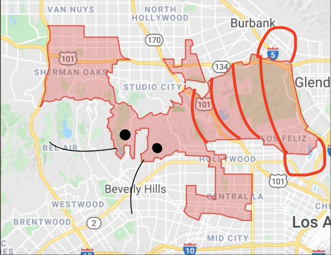
In case readers aren’t already familiar with the heavily-gerrymandered (read Raman’s Twitter thread) Council District 4, here’s the lobster – which includes parts of Sherman Oaks, North Hollywood, Hollywood, Los Feliz, Silver Lake, and Miracle Mile:
Below is a list of some possibilities for bus, bike, and walk improvements – though these categories end up being a bit artificial, as there is quite a bit of overlap.
Also note that although Raman is taking L.A.’s 2015 Mobility Plan seriously – in a way that pretty much no councilmember has to date – this list goes beyond that plan in many places. The Mobility Plan paints an important multi-modal vision for the city, but what appears feasible today isn’t entirely the same as what was approved in 2015. Many recent advances – including new bus lanes on Flower Street and Aliso Street and many of the bike lanes installed in recent years – were not in the Mobility Plan.
BUS
Install new bus lanes, starting with high ridership lines. CD4’s highest ridership bus lines (in rough order of highest to lowest) include: 3rd Street, Western Avenue, Beverly Boulevard, Santa Monica Boulevard, La Brea Avenue, and Van Nuys Boulevard.
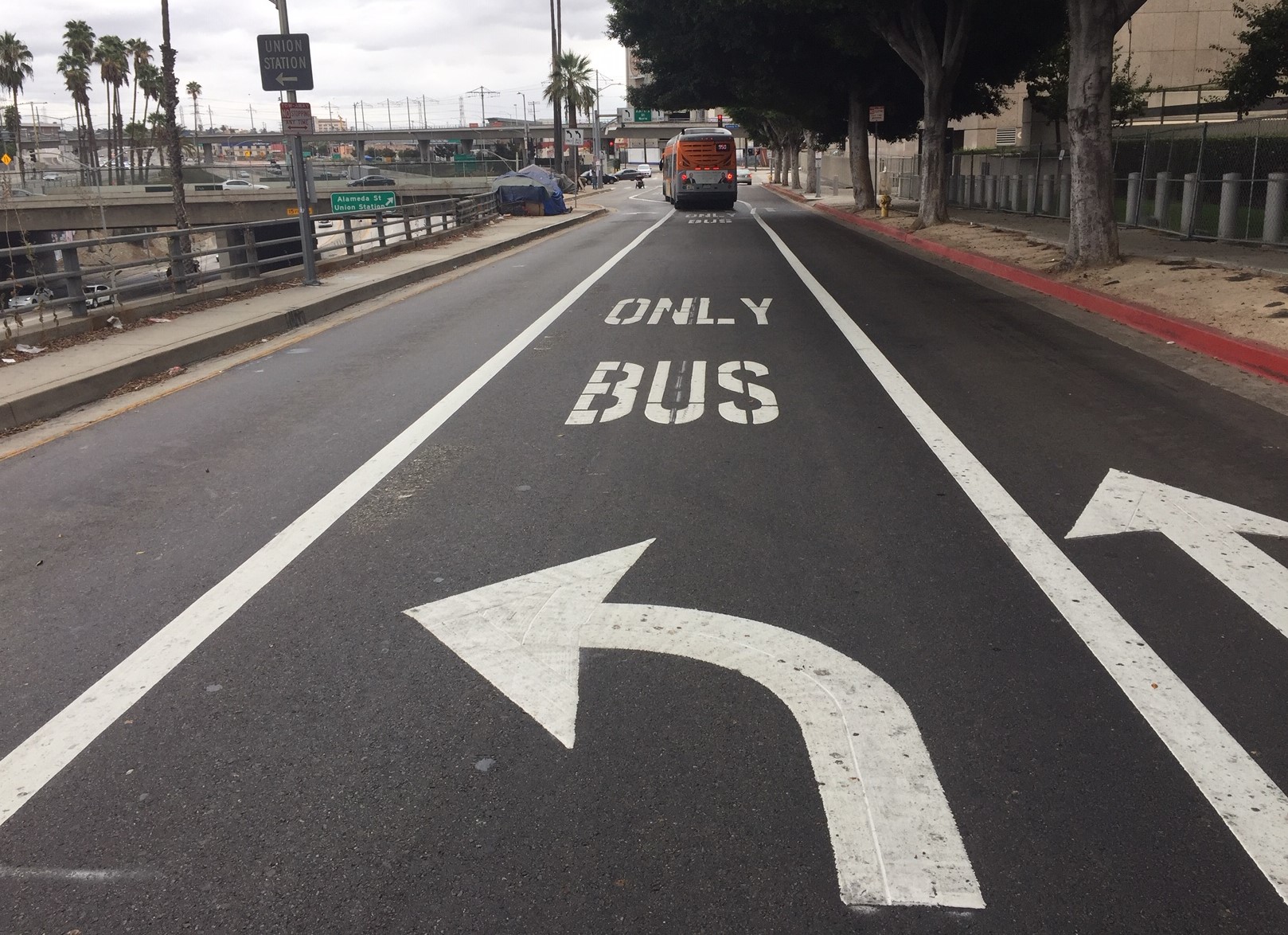
Too often agencies look to install many miles of bus lane at once, then get bogged down in multi-year environmental studies resulting in long delays, spiraling costs, and watered-down facilities. Short busways can be implemented fairly quickly – and can make a big difference. Santa Monica’s five-block long Santa Monica Boulevard bus lane helps get buses quickly through its congested downtown core. Downtown L.A.’s new three-block long Aliso Street bus-only lane is very effective in addressing one heavy congestion spot. Some key factors that made Aliso Street happen: 1) bus drivers and bus riders asked for it, and 2) Councilmember Mike Bonin brought LADOT and Metro together in a bus speed work group. Raman and the rest of the Council should get behind that work group’s efforts (which lack the political support to install quick-build projects in quick-build time frames) to install new bus lanes in the urban core and strategically throughout the city.
Inside CD4, here are a few higher-ridership bus-only lane segments that may make sense to prioritize:
- 3rd Street – Metro Line 16. An all-CD4 quick-build might be from Western Avenue to Rossmore Avenue. Extend the facility further east in collaboration with Councilmembers Mark Ridley-Thomas and Mitch O’Farrell, and west with Councilmember Paul Koretz.
- Beverly Boulevard – Metro Line 14. An all-CD4 quick-build might be from Western Avenue to Van Ness Avenue. Ideally, the facility would extend east to Beverly/Vermont Station, in collaboration with Ridley-Thomas and O’Farrell.
- Santa Monica Boulevard – Metro Line 4. This is in the Mobility Plan, but fewer than a dozen blocks (just east and west of Highland Avenue) are in CD4. For the best results, this would be a collaboration with the city of West Hollywood and O’Farrell.
- Western Avenue – Metro Lines 207 and 757, and Hollywood/Wilshire DASH – Western is shared between CD4, Ridley-Thomas, and O’Farrell. A very useful segment (that Raman has roughly half of) would be from the Wilshire/Western Station to Melrose Avenue.
Support Metro NoHo-Pasadena Bus Rapid Transit. Make sure the North Hollywood end of the Metro BRT project is designed to maximize benefits to bus riders and pedestrians.
WALK
Fund and implement pedestrian safety measures. The city budget has proposed cuts to vision zero outreach, sidewalks, complete streets, speed humps. These programs need support, especially the city’s legally mandated sidewalk repair program “Safe Sidewalks”, which needs to be more accountable and effective.
Ensure pedestrian access to public facilities. Too often, the city assumes that people won’t walk to public facilities. Two new Metro stations are under construction in CD4, at Wilshire/La Brea and Wilshire/Fairfax, and pedestrian access needs to be prioritized there. Re-open the Beachwood Drive entrance to Griffith Park.
Make car-free spaces. Where pedestrians share space with drivers, too often drivers take over. L.A. needs car-free spaces. These can be permanent, such as People St plazas. But they can also be temporary, such as CicLAvia open streets events. Temporary closures might be more frequent than CicLAvia, such as recurring road closures in Griffith Park (more on this below).
Encourage street vending. Vendors contribute to walkable safe vibrant communities. Work with the L.A. Street Vendor Campaign (LASVC) to support vendors in CD4 and throughout the city. Eliminate vendor prohibition zones.
BIKE
Relatively easy short term
Implement some quick-build protected bike lanes. Council District 4 potential low-cost (minimal-to-no car lane or parking removal) protected bikeway sites include:
- Chandler Boulevard – from the Orange Line path to the Tujunga Wash. LADOT received a grant to convert existing Chandler bike lanes to protected bike lanes extending from the North Hollywood Station to the Orange Line path. The majority of the project is in Councilmember Paul Krekorian’s district – though the westernmost couple blocks are CD4. Quick-build protected lanes in the CD4 portion of the project would serve as a visible example of what could be done, and could help spur the project to completion.
- Riverside Drive – from Camarillo Street/Tujunga Avenue to Vineland Avenue. According to Zach Rynew of CiclaValley, the freeway-adjacent bend here sees speeding and “a ton of collisions.” Bike lanes would effectively narrow the street, helping reduce speeds. It appears feasible to add protected bike lanes eastbound from Tujunga to the 134 offramp, and westbound from Vineland to Hortense Street. For the remainder, space may be sufficient for a parking-protected bike lane or a conventional bike lane.
- Rowena Avenue – from Glendale Boulevard to Hyperion Avenue. In 2019, LADOT analysis of the existing Rowena bike lanes recommended upgrading to buffered or protected bike lanes, stating that Rowena’s “street width can accommodate this facility without additional changes.” (Fairly soon, these lanes could be extended east, too)
- Tesla Avenue – from West Silver Lake Drive to Armstrong Avenue. This short one-way street is currently a weak link in the popular reservoir walk/bike loop. Today, pedestrians and cyclists already walk and bike in the street on Tesla – often against oncoming car traffic. Adding an eastbound counterflow protected bike lane would better support current usage, encourage bicycling, calm car traffic, and make Tesla safer.
Add more conventional bike lanes. Council District 4 potential low-hanging-fruit bike lane streets include:
- 8th Street – from Windsor Boulevard to Wilton Place. This relatively wide low-volume street has an arguably little-needed center turn lane that could be narrowed to free up space for bike lanes.
- Burbank Boulevard – from Sepulveda Boulevard to Kester Avenue, and from Van Nuys Boulevard to Hazeltine Avenue. In January, LADOT added new Burbank Boulevard bike lanes from Kester to Van Nuys. These additional segments would close a gap and extend the bikeway nearly to the Sepulveda Basin.
- Cahuenga Boulevard East – from Pilgrimage Bridge to Benda Street. This is the least hilly of all the hilly ways to get from the basin to the Valley. In the long run, bike lanes should extend further on each end (and be coupled with a southbound facility), but this one-way one-mile portion can be done without impacting anything. Parts of it could be protected.
- Camarillo Street – from Cahuenga Boulevard to Camarillo Place.
- Franklin Avenue – from Wilcox Avenue to Vine Street. Short fairly wide stretch of Franklin has space for bike lanes connecting to Cahuenga bike lanes. Along the north side (including along Franklin-Ivar Park) a portion could be protected bike lane.
- Hyperion Avenue – from Rowena Avenue to Hyperion bridge entrance above Ettrick Street. Short stretch of bike lanes that would connect to Rowena lanes and future bike lanes on Hyperion Bridge. Southbound along Rowena Reservoir, it could be a protected bike lane.
- Moorpark Way – from Moorpark Street to Riverside Drive.
- West Silver Lake Drive – from Tesla Avenue to Rowena Avenue. This short stretch with over-wide streets would connect bicyclists from Rowena to the reservoir loop.
Take advantage of repaving to implement bike/bus/walk improvements. One promising recent development has been an increase in new and upgraded bikeway facilities on streets being repaved as part of Streets L.A.’s ADAPT repaving program. LADOT and Streets L.A. are already doing this, but missing some opportunities. In the short run, new bikeways can be added where repaving is already scheduled. This shouldn’t be limited to just bikeways, but also facilities for transit and walking: bus lanes, curb extensions, etc. In the longer run, Councilmembers can prioritize repaving on streets where new busway and bikeways are being installed.
Medium to long term
Implement 6th Street safety upgrades. Taking his cue from homeowner NIMBYs, Ryu killed planned 6th Street road diet safety improvements located a block north of Metro’s under-construction subway. Raman could revive (and probably upgrade) LADOT’s planned Sixth Street safety improvements.
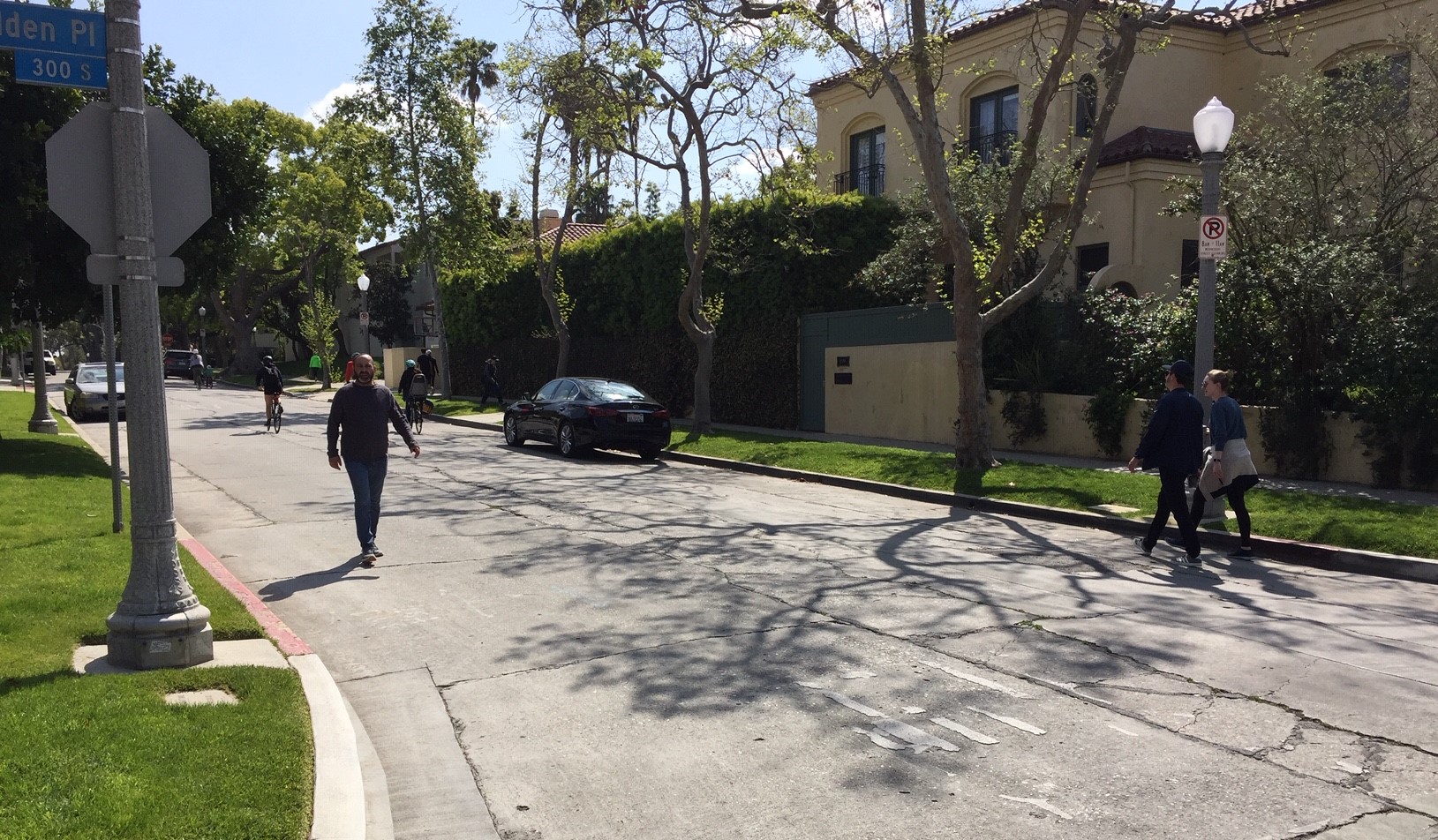
Prioritize bicycling and walking on 4th Street. Under COVID, 4th Street has supported a steady stream of cyclists, pedestrians, joggers, and dog-walkers, including many families. Fourth Street could be even better shared if walking and bicycling were prioritized (this type of facility has various names; the city calls it a bike-friendly street. It is also called a neighborhood greenway or a bike boulevard.) Fourth needs a few new crossing features at places where perpendicular car traffic is heavy, including at Highland and Rossmore Avenues. Treatments there should allow pedestrians and cyclists to cross while preventing cut-through car traffic. Like CicLAvia, this could be the kind of thing that some concerned parties will resist, but then once it’s in place, many come around to loving it.
Expand the low-stress bicycling network. A lot of L.A.’s bicycling and walking takes place on quieter streets, like 4th Street (above.) LADOT is analyzing which low-stress streets are conducive to bicycling and the barriers that interrupt those streets. Councilmembers should work with neighborhoods to tame those barriers – creating a low-stress network, preferably with connections to paths, schools, parks, and transit. Some CD4 streets that probably warrant these sort of improvements include: 4th Street, 8th Street (Miracle Mile), Addison Street, Mansfield Avenue, Noble Avenue (see river connection below), and Orange Drive.
Make first/last mile walk and bike connections to Metro rail. Many CD4 residents are already within a short bike ride of Metro B (Red) Line stations at Hollywood/Highland, Universal, and North Hollywood – if only there were safe convenient ways to go. Some connections that could be important:
- Hollywood/Highland Station: Councilmembers Raman and O’Farrell should ensure adequate bike/walk access to the surrounding community and nearby destinations, including the Hollywood Bowl and Ford Amphitheater. The city’s Complete Streets program is planning safety improvements to Highland Avenue from Franklin Avenue to Santa Monica. This may include making a quieter parallel street bike-friendly, probably Orange Drive – which could line up with LADOT and neighborhood council plans for making Orange Drive bike-friendly through mid-city.
- New Purple Line stations at Wilshire/La Brea and Wilshire/Fairfax: Bike connections are needed for these under-construction stations. These likely link to improvements on 6th Street and 8th Street mentioned above.
- Metro Bike Share: Bike-share is expanding to Hollywood in Spring 2021. Councilmembers need to make sure the planned expansion actually happens and that they make it effective by creating safe places to ride and walk. Ensure later bike-share expansion serves new Purple Line Stations.
Make Griffith Park a great place to bike. Griffith Park, L.A.’s largest and arguably most iconic and most beloved park, prioritizes accommodating rush-hour car traffic. The park does serve bicyclists, who heavily use hilly closed-to-car-traffic park roads. But the park lacks good places for youth and families to bicycle. It’s also difficult to get to the park via bicycle. There needs to be a community planning process, but some relatively quick pop-up pilots might be able to showcase solutions. Some ideas:
- Install a long continuous protected bikeway on the flat spine of Griffith Park: Crystal Springs Drive, Western Heritage Way, and Zoo Drive. An optimal facility would probably be a two-way parking-protected bikeway on one side of the street. This could involve removing cars from portions of park roads and converting them to walk/bike-only corridors – think CicLAvia. One possible bike/walk-only street could be much of the west (southbound) half of Crystal Springs Drive. Closures could be permanent, but could also be piloted in limited time frames, such as every Sunday, or every weekend for a month.
- From that spine, grow a network. Include spurs inside the park, perhaps: 1) Riverside Drive from Zoo Drive to at least the L.A. River path (perhaps to further to Victory/Sonora), and 2) North Zoo Drive to the L.A. River path entrance by the Ferraro soccer fields.
- Extend the network alongside and outside the park, perhaps including: 1) Forest Lawn Drive from Zoo Drive to Barham Boulevard, 2) Riverside Drive from Los Feliz to Silver Lake Boulevard, 3) Los Feliz Boulevard from Crystal Springs to the L.A. River path, and 4) add path/s in the Griffith Park Recreation Center site to connect Sunnynook footbridge to Riverside Drive.
Expand river bike/walk paths. Metro has Measure M funding to finish the L.A. River walk/bike path along 50 miles from Canoga Park to Long Beach. The project is anticipated to be completed for the 2028 Olympics. There has not been much progress through the East Valley, though L.A. City has some additional Proposition K park bond funding for that stretch. Council District 4 has about eleven miles of the L.A. River, plus a couple miles of its Tujunga Wash tributary. Paths along these waterways can serve as great car-free spaces to walk and bike. Some work that can get underway fairly soon:
- In the middle of the Valley where the river crosses under the 405 Freeway, L.A. City plans call for an on-street connection – mainly on Noble Avenue – between the river path and the Orange Line path. Work with the community to plan and install this.
- The East Valley river path is difficult due to fairly expensive grade crossings at north-south streets. Neighbors support an at-grade signalized bike crossing at Kester Avenue, which could be part of a project that would extend the existing short path eastward from Kester to Van Nuys Boulevard. Raman could finalize plans, pursue funding, and get this built.
- To connect the Valley path to the one at Griffith Park, the city will need to work with studios – in CD4 that is Universal and Warner Brothers. Potentially these institutions could be partners in getting the path built. Get these conversations started.
- Connect people to the river via walk, bike, and transit routes. Many neighborhoods, including Silver Lake, are largely within walking distance of the river. Many more are an easy bike ride away, but unsafe streets prevent communities from accessing the river. Councilmembers need to work with communities to plan and implement safe routes to the river. One place Raman could start is in Silver Lake. Ryu failed to support bike and walk improvements on Glendale Boulevard, which would connect to the new Red Car pedestrian bridge. Raman could revive these plans.

Read More:
Streetsblog has migrated to a new comment system. New commenters can register directly in the comments section of any article. Returning commenters: your previous comments and display name have been preserved, but you'll need to reclaim your account by clicking "Forgot your password?" on the sign-in form, entering your email, and following the verification link to set a new password — this is required because passwords could not be carried over during the migration. For questions, contact tips@streetsblog.org.


