
Metro Re-Approves Randolph as Rail-to-River Route After Dedicated Bike/Walk Path Plan Had to Be Scuttled
This past Thursday, the Metro Board voted to (again) move ahead with Randolph Street as the route for Segment B – the eastern segment of the Rail-to-River bike/walk path.
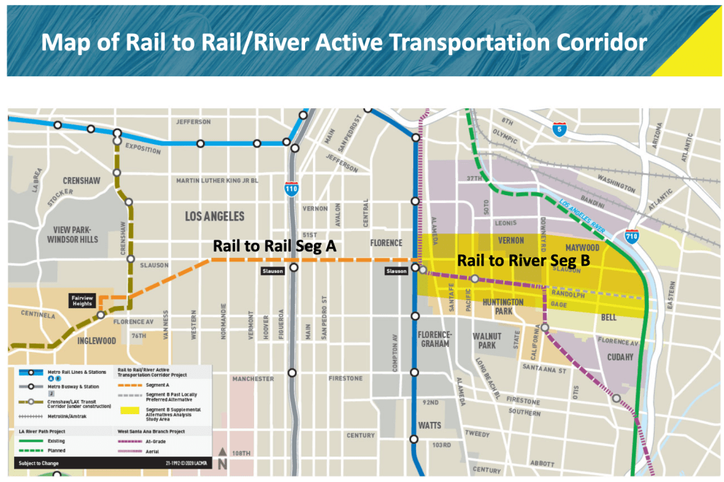
Cutting through and along the edges of Florence-Firestone, Huntington Park, Bell, Vernon, and Maywood, Randolph was the preferred route Metro had approved back in 2017. Soon after approval, however, the project collided with both the planned West Santa Ana Branch (WSAB) rail line in Huntington Park and Union Pacific’s unwillingness to abandon its defunct right-of-way (ROW). That meant the Rail-to-River plans for Randolph would have to be significantly retooled. As a result, Metro (rather half-heartedly) relaunched the visioning process for the Southeast cities route last February.
Thursday’s re-approval of Randolph moves the full 10-mile Rail-to-River project back on track to fruition, though not in quite the same form it was originally expected to take.
When first proposed in 2012 by then-Metro boardmembers Mark Ridley-Thomas and Gloria Molina, the ambitious project was conceived as a way to convert a ROW deemed infeasible for passenger rail into a green ribbon stretching across an intensely park-poor section of South and Southeast Los Angeles.
That vision is (relatively) easier to accomplish along the South Central portion of the route (the orange Segment A line, above) because Metro already owns the Slauson ROW.
To that end, Metro is already at work ripping out the tracks running the 5.5 miles between the Crenshaw Line’s Fairview Heights station and the Slauson Blue Line station. They will be replaced with dedicated bike and walk paths, new shade trees, drought-tolerant landscaping, lighting, intersection improvements, and bioswales.
[Segment A broke ground just last month and is expected to be completed by early 2024. See our coverage of the groundbreaking and the history of both the project and that section of the corridor here; Metro renderings of Segment A are below.]
Metro chose Randolph Street for Segment B, in part, because of the expectation that the center-running ROW there would also support a similarly separated bike/walk path (below).
That wasn’t the only reason: although Randolph is one of the few main east-west streets running all the way through the SE cities, it starts at Slauson and ends at the river, so it sees far less through-traffic. It also provides a direct connection to the river while linking the greatest number of communities together. And the ROW was already utilized by some in the community as a jogging path, meaning the project would be enhancing an existing asset. Early proposed alternative routes along Slauson or through Vernon couldn’t compete.
The WSAB Transit Corridor project – a 19-mile light rail line intended to better connect the Gateway Cities to Downtown Los Angeles – will now be using that ROW in Huntington Park. Its northern alignment will run along the Salt Lake Avenue corridor before turning west on Randolph and heading toward the Long Beach Boulevard corridor.
Despite the blighted condition of the corridor at present, Union Pacific has no plans to remove its tracks to make way for the WSAB. Consequently, Metro will have to build around the existing infrastructure. That means widening the Huntington Park section of the ROW to make room for two sets of light rail tracks.
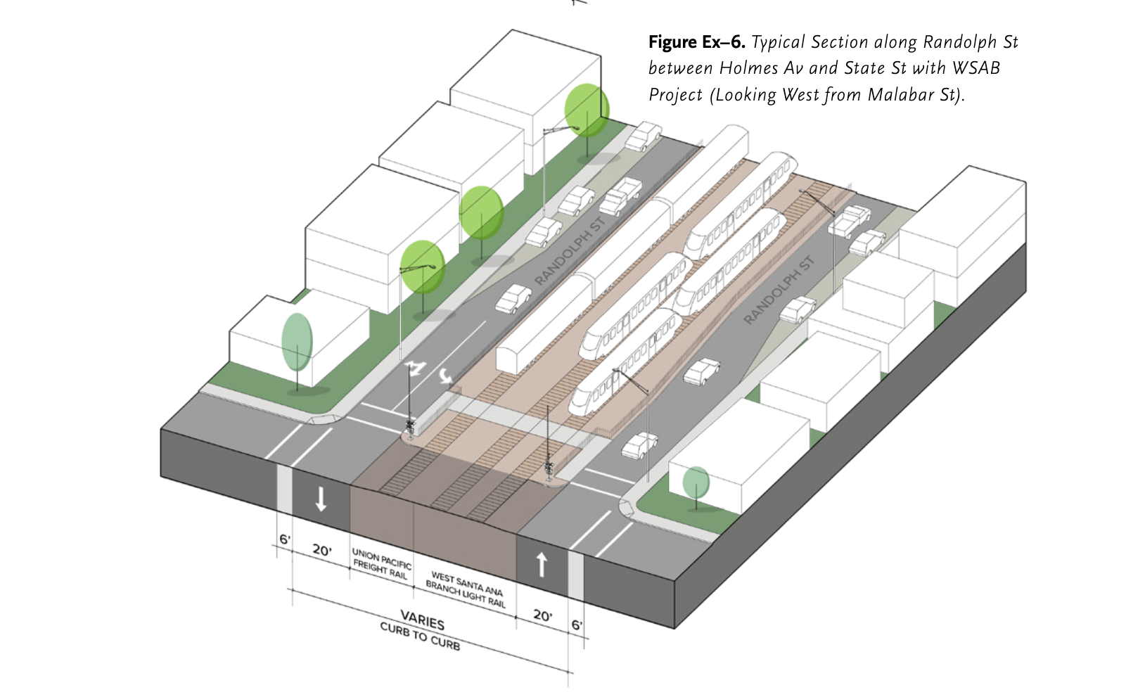
As a result, Randolph will be reconfigured through much of Huntington Park: west of Boyle/State, the two travel lanes that run in each direction will be reduced to a single lane and the number of intersections along Randolph will be reduced, something which Metro says will further reduce traffic volumes and also potentially allow for the reduction of the corridor speed limit to 20-25 mph.
Because parking will be retained along the corridor, there is no room for a separate bike facility between Holmes Avenue and State Street. Bicyclists will have to share those 1.6 miles with vehicular traffic.
The resulting bicycle boulevard will look something like the rendering below.
Though the project will also feature new sidewalks, improvements at intersections (e.g. curb extensions, high visibility crosswalks, and improved or new pedestrian signals), improved lighting, streets trees, wayfinding, and shade structures, per the executive summary of Metro’s report, it appears plans for a dedicated walking path have also been shelved.
Full construction of the WSAB is not expected to get underway until at least 2026, however. So Metro has proposed that bicycle lanes be striped between Holmes and State in the interim (below).
Perhaps by that time, Metro and Huntington Park will have arrived at some other solution for that section of the project. Huntington Park’s own bicycle master plan had also called for a bicycle path along the ROW and for bicycle lanes to be striped along Randolph in the interim. Community feedback cited in that master plan had also shown strong support for the transformation of Randolph into a multi-modal corridor.
Cyclists continuing eastward along Randolph toward the river will have somewhat more protection once they cross State Street. There, Metro proposes a two-way bikeway be installed with a narrow median (possibly featuring street trees) separating bikeway users from vehicular traffic. The bikeway would be approximately two miles long.
Details on how this will be accomplished are not included in Metro’s summary report, though it seems likely that it will involve some shuffling around of parking; the bikeway will go in where the row of cars parked at left (below) are now.
Frustratingly, Metro did indicate in its report that the bikeway could be downgraded to bike lanes or even a bicycle boulevard if it proved too difficult to remove parking.
Bell’s bike plan for Randolph does include a two-way bikeway (as well as a walking path on the Union Pacific Row) and labels it a “priority project.” Hopefully it will remain committed to that plan.
Newly installed Metro Board Chair Ara Najarian asked that project come before the board again in October 2022 with a funding plan for further development of the project.
For more details on the Segment B presentation and discussion, see the Metro board report, etc. here.
See our previous coverage below:
- July, 2022: Rail-to-Rail Bike/Walk Path Breaks Ground on Slauson; Officials Speak to Its Significance for Corridor
- February, 2021: Metro Relaunches Rail-to-River Engagement Process to Choose New Southeast Cities Route
- December, 2019: Rail-to-Rail Bike/Ped Path along Slauson Delayed but Moving Forward
- July, 2017: Metro Offers Update on Rail-to-River Bike/Ped Path Design; Project to Break Ground Mid-2018
- January, 2017: Metro Seeks Input on Design Options for Segment A of Rail-to-River Bike/Pedestrian Path
- December, 2016: Preview Some of the Design Options for the Slauson Segment of the Rail-to-River Bike/Pedestrian Path (self-explanatory)
- December, 2016: Rail-to-River Route Through Huntington Park, Bell Emerges as Best Candidate; Community Meeting December 8 (The Randolph Street option emerges as the favorite while also the most expensive and most complicated option; Community Advocates demand Metro handle outreach better and incorporate walking into plans better)
- October, 2016: Metro Asks South L.A. Stakeholders: How Would You Use Rail-to-River Bike/Pedestrian Path?
- August, 2016: Metro Explores Alternative Rail-to-River Routes Through Southeast Cities (where we learn Metro and the Southeast Cities do not play together well)
- May, 2016: Metro Awards Contract for Environmental Study and Design of Phase I of Rail-to-River Bike Path (OMG it is actually happening; request that outreach finally be meaningful)
- October, 2015: The Rail-to-(Almost)-River Gets Boost with $15Mil TIGER Grant (yay, actual money!)
- May, 2015: Planning and Programming Committee Recommends Metro Board Take Next Steps on Rail-to-River ATC (more on costs, timelines)
- October, 2014: Motion to Move Forward on Rail-to-River Bikeway Project up for Vote Thursday (breaks down the feasibility study in more detail, costs, timeline)
- March, 2014: Feasibility Study on Rail-to-River Project Takes Another Step Forward (plan begins to come together; outreach still a major problem)
- December, 2013: Dear Santa, Please Bring Us an Active Transportation Corridor Along Slauson, but Don’t Forget the Community in the Process (background on the plan; lack of outreach)

Streetsblog has migrated to a new comment system. New commenters can register directly in the comments section of any article. Returning commenters: your previous comments and display name have been preserved, but you'll need to reclaim your account by clicking "Forgot your password?" on the sign-in form, entering your email, and following the verification link to set a new password — this is required because passwords could not be carried over during the migration. For questions, contact tips@streetsblog.org.


