
Some Actionable Transportation Ideas for Councilmember-Elect Hugo Soto-Martinez
In the November runoff election, L.A. City Councilmember-elect Hugo Soto-Martinez soundly beat incumbent Mitch O’Farrell. Next week, Soto-Martinez will be sworn in to represent the city’s 13th Council District, located in central and northeast Los Angeles.
Soto-Martinez is a former labor organizer who joins a growing cohort of progressive councilmembers. His far-reaching platform includes too many transportation/climate/livability planks to list here. (Among his opponent’s faults was a record of canceling walk/bike safety improvements.) Soto-Martinez’ platform includes:
- Install a comprehensive network of protected bike lanes throughout CD13
- Install new bus lanes across the district
- Make walking around L.A. easier and safer
- Get Metro to: increase the frequency of buses and trains, implement fare free transit, allow street vendors at Metro stations, and hire Transit Ambassadors
- Address gender barriers for public transit
- Make Sunset Boulevard a safer place to shop, dine, and travel with Sunset for All
- Construct more housing near public transit
- Oppose freeway expansions and widening
As with earlier SBLA council district ideas posts (see recent CD1, CD4, CD5, and CD14 pieces), this post focuses on potential bus, walk, and bike projects located in CD13. Streetsblog checked in with a some L.A. transportation advocates (including incorporating much of Streets for All founder Michael Schneider’s CD13 post), and took a long look at Soto-Martinez’ district to come up with a list of suggestions on how the new councilmember might get started on implementing his “transportation with an equity focus” vision.
Where is Soto-Martinez’ Council District 13?
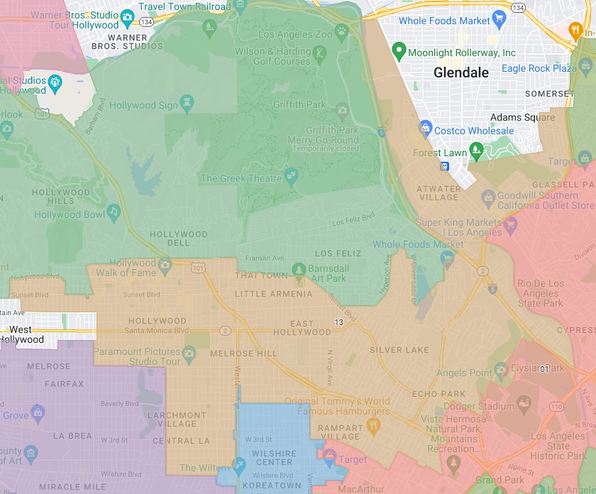
Much of CD13 is Hollywood and nearby neighborhoods including East Hollywood, Echo Park, and Silver Lake. The district also has extends northeast into the communities of Atwater Village, Elysian Valley, and Glassell Park.
What follows is a long list of potential CD13 transit, walk, and bike projects. Most of these are relatively easy. Scroll down for some that are more ambitious.
Install new bus lanes, starting with high ridership lines.
Adding new bus lanes for any significant distance will require removing something – generally on-street parking or a driving or turn lane. Though nearly any street where buses go would benefit from bus lanes, removing some car capacity can trigger resistance. So it makes the most sense to prioritize high ridership locations that offer the greatest benefits to the most riders.
The city’s Mobility Plan 2035 approved four bus lanes in CD13, below listed in order starting from bus lane projects are furthest along:
- CD13’s short portion of Wilshire Boulevard already has bus lanes, which carry nearly 30,000 daily riders. Soto-Martinez could support the planned pilot for on-bus camera parking enforcement on Wilshire starting in 2023 (see Council File 21-1224).
- This week, LADOT and Metro are installing bus lanes on La Brea Avenue from Sunset Boulevard to Olympic Boulevard, which includes most (5 of 8 blocks) of the short stretch where the Metro 217 La Brea bus (daily ridership ~8,000) runs in CD13. It appears possible to extend LADOT’s planned bus lanes above Sunset Boulevard to Hollywood Boulevard. Though lots of folks would benefit from this facility, it probably wouldn’t be the top priority, as La Brea is not among Metro’s or CD13’s highest ridership bus routes.
- Vermont Avenue is currently Metro’s highest ridership bus corridor, so it presents a great opportunity to improve mobility and quality of life for about 30,000 daily Metro bus riders (plus a couple thousand LADOT DASH riders). CD13 includes a two-mile-long portion of Vermont from Hollywood Boulevard to Third Street (with a few blocks shared with CD10). Metro has a longstanding, painfully slow-moving effort to build Bus Rapid Transit (and ultimately, south of Wilshire, a subway) there. CD13 (perhaps working with other districts – could include CD 1, 8, 9, and 10) should get behind this Metro effort, including pushing to get needed improvements on the ground as soon as possible, perhaps including some sort of quick-build demonstration.
- Santa Monica Boulevard line 4 carries about 20,000 riders per day. MP2035 approved lanes there between La Brea and Sunset, which is all CD13. Installing bus lanes would mean curtailing some parking, either permanently or at peak hours. CD13 should work with LADOT and Metro to evaluate what it would take to install bus lanes on SMB serving high ridership areas, then implement the lanes. An initial busway segment should serve the Vermont/SMB Station. An ambitious full MP2035 build-out would include bus lanes, protected bike lanes (recommended by Schneider), and probably a lot less on-street parking.
There are a few more high-ridership CD13 bus routes on streets that are not already approved, but would make sense for fulfilling Soto-Martinez’ pledged “Bus Lanes across the district”:
- From Alvarado Street to Santa Monica Boulevard (all in CD13), Sunset Boulevard is a trunk route where two high ridership Metro lines converge. This part of Sunset carries Metro lines 2 and 4 (18,000 and 21,000 riders daily, respectively). This area is part of the proposed Sunset4All bike/walk improvements, which could perhaps be implemented in tandem with new bus lanes.
- Shared with CDs 1 and 10, Third Street carries about 18,000 riders daily. An initial segment of 3rd Street bus lanes could make sense between Lafayette Park Place and Vermont where there is no on-street parking.
- Expand the hours of the Alvarado Street bus lane (shared with CD1).
WALK
Repair sidewalks
The most fundamental need for walkable places is sidewalks, and the city’s legally mandated sidewalk repair program, “Safe Sidewalks,” needs councilmembers committed to making it more effective, responsive, and transparent. CD13 should work with communities to identify and complete needed sidewalk repairs, with a strong emphasis on the needs of folks with disabilities.
Supporting street vending, including at subway stations
Soto-Martinez has often referenced his immigrant parents’ work as street vendors. Vendors contribute to walkable, safe, and diverse communities. CD13 should work with the L.A. Street Vendor Campaign (LASVC) to support vendors there and throughout the city. Eliminate vendor prohibition zones, as vendors are currently demanding in court. Vendors should be welcomed to activate all six CD13 Metro B Line stations: Vermont/Beverly, Vermont/Santa Monica, Vermont/Sunset, Hollywood/Western, Hollywood/Vine and Hollywood/Highland. The Alliance for Community Transit has pushed for and demonstrated greater activation of Metro stations; though Metro resists it (outside of some very limited pilots), street vending should be one aspect of a community approach to Metro public safety. CD13 could start by working with Metro and community groups (such as LASVC, ACT-LA, Inclusive Action for the City) to initiate several more station vending pilots, which should lead to a broader framework where Metro can manage (and hopefully learn to embrace) station vending.
Reclaim excess car space for walkability
There are some big opportunities for pedestrian spaces (see Hollywood Boulevard, below) but one worthwhile opportunistic place to start would be slip lanes, and similar triangular spaces given over to drivers at the expense of making walking more dangerous.
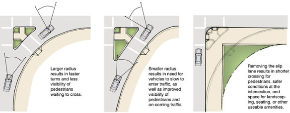
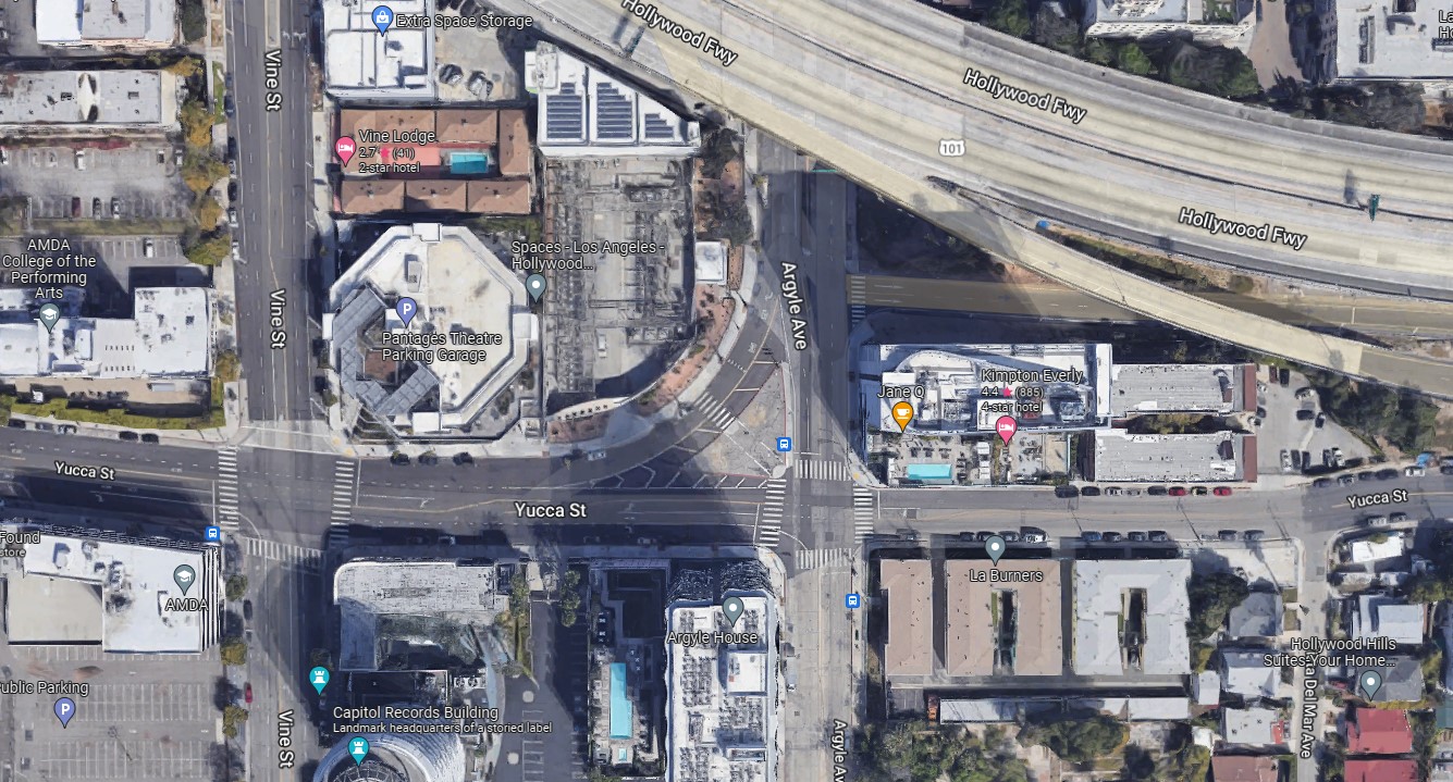
These slip lane spaces come in different scales, and CD13 has some of the worst in the city – especially the one at the intersection of Argyle Avenue and Yucca Street in Hollywood.
Some CD13 slip lanes (and similar triangular street spaces given over to driving) to reconfigure for walkability include:
- 3rd Street/Grand View Street
- 6th Street/Norton Avenue
- Argyle Avenue/Yucca Street
- Bellevue Avenue/London Street
- Fletcher Drive/Marguerite Street
- Fountain Avenue/Hyperion Avenue
- Glendale Boulevard/Allesandro Street
- Glendale Boulevard/Apex Avenue
- Glendale Boulevard/Lake Shore Avenue
- Glendale Boulevard/Park Avenue
- Echo Park Avenue/Morton Avenue
- Riverside Drive/Stadium Way
- Santa Monica Boulevard/Myra Avenue
- Temple Street/Belmont Avenue
- Temple Street/Virgil Avenue
- Vine Street/101 Freeway ramp
- Virgil Avenue/Santa Monica Boulevard
- Virgil Avenue/Fountain Avenue/Virgil Place
- Vermont Avenue/1st Street
Lastly, CD13 famously has a couple of prominent scramble intersections in Hollywood. Below are a few more potential location for additional scrambles:
- Beverly Boulevard/Vermont Avenue (shared with CD10)
- Hollywood Boulevard/Western Avenue
- Santa Monica Boulevard/Vermont Avenue
- Sunset Boulevard/Alvarado Street
BIKE
Revisit canceled bike improvements
Soto-Martinez could revive two worthwhile bikeway projects killed by O’Farrell:
- Fletcher Drive – O’Farrell canceled proposed Vision Zero improvements on Fletcher Drive between San Fernando Road and Riverside Drive. Get the plans, upgrade where possible, and implement the project.
- Temple Street – Beaudry Avenue to at least Alvarado Street. In 2018, councilmembers O’Farrell and Gil Cedillo colluded to kill planned Vision Zero road diet safety improvements on Temple Street. Work with CD1 to resurrect the plans. See what might be upgraded to include some protected bikeway, which appears possible at least between Virgil Avenue and maybe Vendome Street, also near Benton Way. Install.
Install relatively easy short term bikeways
Implement quick-build protected bike lanes. Council District 13 potential low-hanging fruit (minimal-to-no car lane or parking removal) protected bikeway sites include:
- Bellevue Avenue – Belmont Avenue to dead end near Alvarado Street. This over-wide street could easily fit a two-way protected bikeway, which could connect to the bike/walk bridge over the 101 via Belmont.
- Cole Avenue – Cahuenga Boulevard to Melrose Avenue. This is an over-wide street with stretches of diagonal parking on one side. A one- or two-way protected bikeway could be tucked between the diagonal parking and the curb, similar to Eldridge Avenue in Sylmar.
- La Fayette Park Place – Beverly to 3rd. Like Cole above, a protected bikeway could be added behind diagonal parking, similar to Eldridge. The bikeway could continue south in CD1.
- Glendale Boulevard – Alvarado to Park Avenue. MP2035 approved protected bike lanes for Glendale Boulevard (all the way from Fletcher to downtown). This stretch (part of which already has unprotected bike lanes) has space to easily accommodate protected bike lanes.
- Kenmore Avenue – Rosewood Avenue to Clinton Street. This is one over-wide block with diagonal parking. The unneeded block-long extra traffic lane could make way for a two-way protected bikeway behind the parking.
- Riverside Drive – Fletcher Drive to the Riverside-Figueroa Bridge. After O’Farrell lost his primary and could read the writing on the wall, in the spirit of “look busy,” he authored a couple of half-baked last minute pro-bike motions to make it appear that he had a shred of support for bicycling. (As far as SBLA can tell, he didn’t fool cyclists.) One motion supports Sunset4All (see below) and the other directs the city to implement MP2035-approved bike lanes on Riverside and Stadium Way. Nearly all of Riverside has plenty of space to add protected lanes. (Also coordinate with CD4 to close the protected bikeway gap from Glendale Boulevard to Fletcher.)
- Silver Lake Boulevard – Duane Street to Armstrong Avenue. Along the reservoir, portions of the Silver Lake Boulevard bike lanes could be upgraded to protected.
- Stadium Way – Riverside to Academy Road. This is part of the Riverside Drive motion noted above. Inside Elysian Park, it would make most sense to do an all-ages facility: a two-way protected bikeway.
- Temple/Silver Lake connector – Temple Street to Silver Lake Boulevard.
- West Silver Lake Drive – elbow (at Silver Lake Recreation Center) to walk path entrance. This stretch could use a parking-protected one-way uphill bike lane and downhill sharrows.
Add more conventional (unprotected) bike lanes. Council District 13 potential low-hanging-fruit bike lane streets include:
- Belmont Avenue – Temple Street to Beverly Boulevard.
- Beverly Boulevard – Temple Street to Commonwealth Avenue. Basic bike lanes would fit in this no-parking stretch of Beverly.
- Carondelet Street – Temple Street to Beverly Boulevard.
- Echo Park Avenue – Cerro Gordo Street to Bellevue Avenue (below Sunset shared with CD1). There is just enough space for basic bike lanes. An even better treatment (that would probably involve some parking removal) would be a protected bikeway (especially along the park itself).
- Fletcher Drive – Avenue 36 to Avenue 38.
- Glendale Boulevard – Glenhurst Avenue to the 5 Freeway (ideally continuing in CD4 to Rowena). Glendale Boulevard tends to be one of the least awful streets for cyclists to get from Silver Lake to the L.A. River path. CD13 can’t easily solve all the river access issue there (beginners and families will still ride on the sidewalk), but there does appear to be just enough room to squeeze in basic curb-hugging bike lanes. On the freeway bridge (half in CD4), there is enough space for protected bike lanes.
- Heliotrope Drive – Santa Monica Boulevard to Melrose Avenue. Basic bike lanes should fit; it may be possible to tuck a protected bikeway behind the diagonal parking (like Eldridge).
- Madison Avenue – Melrose Avenue to 101 Freeway.
- Manhattan Place – 2nd Street to Wilshire.
- New Hampshire Avenue – Beverly to Rosewood Avenue. Basic bike lanes would fit; the facility would serve first-/last-mile trips to the Vermont/Beverly Station.
- Oakwood Avenue – Vermont Avenue to Alexandria Avenue.
- Park Avenue – Sunset Boulevard to Echo Park Avenue. Between Sunset and Glendale Boulevard, there appears to be enough width for protected lanes.
- Rosewood Avenue – Vermont to Alexandria Avenue.
- St. Andrews Place – 2nd Street to Wilshire.
- Vendome Street – Del Monte Drive to Sunset.
- Virgil Avenue – 1st Street to Silver Lake Boulevard. Approved in MP2035, basic bike lanes would fit in this no-parking stretch of Virgil.
- Wilcox Avenue – Hollywood Boulevard to Santa Monica Boulevard.
Medium-term bikeways:
The above facilities are all fairly easy and basic. The bike facilities below appear feasible, but would require some lane reconfiguration (mostly removing a center turn lane and/or some parking).
- 3rd Street – Coronado Street to Westmoreland Avenue (shared with CD1). This no-parking stretch of Third would just fit basic unprotected bike lanes (could be in conjunction with bus-only lanes).
- Allesandro Street – Riverside to Glendale Boulevard. Allesandro is one of just a few surface streets that connect Elysian Valley with neighborhoods to the south, though the street suffers from proximity to the 2 Freeway terminus. Adding bike lanes would require some reconfiguration of the continuous center turn lane. There may be enough space to squeeze in parking-protected bike lanes, perhaps a 2-way protected bikeway along the west side of the street.
- Argyle Avenue – Sunset to Franklin Avenue. An Argyle bikeway would connect to the Hollywood/Vine Metro Station. Much of the street has excess width, though it might require reconfiguring some parking, and/or narrowing lanes.
- Beverly Boulevard – Glendale Boulevard to Belmont Avenue. This stretch could use an uphill bike lane, which would involve trimming the painted median lane.
- Bronson Avenue – Hollywood Boulevard to Fountain Avenue. Repurpose some center turn lane space to extend existing bike lanes northward.
- Commonwealth Avenue – 3rd Street to Beverly. Commonwealth is an overly wide residential street, it could fit basic bike lanes by removing the unneeded center turn lane. The facility could extend southward in CD1.
- Ellett Place – Silver Lake Boulevard to Occidental Boulevard. Add a one-way uphill lane (ideally protected) by removing a couple of parking spaces. This could extend to Sunset in the striped-off space on Occidental.
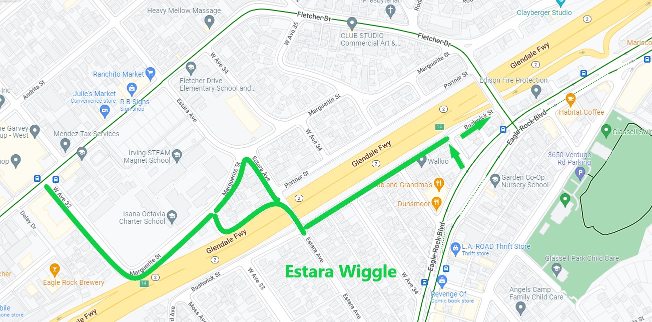
- Estara Avenue Wiggle (shared with CD1). To avoid hills and traffic on Fletcher, some cyclists use a quieter, flatter route that Streetsblog calls the Estara Wiggle: Avenue 32, Marguerite Street, Avenue 33, the alley along the 2, Estara Avenue, Bushwick Street, and Crestmoore Place. The route is already useful, and could be made more so with upgrades. At a minimum, the city could add signage/sharrows. From there it may be possible to add bike lanes on parts of Avenue 33, Estara, Crestmoore, and Bushwick.
- Fountain Avenue – West Hollywood city limit (near La Brea) to Griffith Park Boulevard. Fountain has long been a quiet-ish cyclist alternative to larger parallel streets, though the city has not prioritized active transportation there (beyond it being the site of the city’s first sharrows). Last month, West Hollywood approved installing protected bike lanes to their part of Fountain, which borders on L.A. City. CD13 should support WeHo’s project, and match it eastward to at least to Selma Avenue. In L.A., Fountain’s width varies quite a bit. Some areas would support bike lanes without removing anything. A lot of it is too narrow to easily add a bikeway. CD13 should work with LADOT to come up with solutions that prioritize cyclists along all of Fountain, which would likely entail removing some on-street parking.
- Glendale Boulevard – L.A. River to Glendale city limit (railroad tracks). Upgrade existing bike lanes to protected, which would remove some on-street parking.
- Glendale Boulevard / Rowena Avenue / Fletcher Drive wye (CD13 has half of Fletcher and Glendale, the rest is CD4). Work with CD4 to connect bicyclists through this tangled Silver Lake Y-intersection, especially to connect the Silver Lake Boulevard bike lanes to the L.A. River. Much of Glendale Boulevard has over-wide painted median spaces that could be reallocated. This part of Fletcher (between Glendale Boulevard and the river) is tight, but narrowing lanes should free up enough space for a minimal bikeway.
- Gower Street – Hollywood Boulevard to Melrose. With minimal reconfiguration of some turn lanes, Gower would fit basic bike lanes. South of Santa Monica Boulevard (along the cemetery and studio) lane could be parking-protected.
- Rampart Boulevard – Temple to Beverly. Extend the current Rampart bike lanes north by reconfiguring the center turn lane.
- Wilton Place – 3rd Street to Beverly. MP2035 approved a Wilton bikeway nearly all the way from Sunset to Wilshire in CD13 (and continuing south into CD10). Much of this facility looks difficult, though between 3rd and Beverly, it could be done with fairly straightforward reconfiguration of the center turn lane.
- Verdugo Road – Glendale city limit (Plumas Street) to Eagle Rock Boulevard (one block in CD1). A prior CD14 councilmember had began studying a potential road diet for this part of Verdugo. Dust off the plans and work with the community there to get it done.
- Yucca Street – Cahuenga Boulevard to Gower. Much of this stretch of Yucca has excess width, though it might require reconfiguring some parking and/or narrowing lanes. The facility would connect to the city’s half-baked Yucca bike boulevard.
Longer term bikeway projects:
Below are some longer term bikeway projects that need significant funding and thorough community planning processes.
- Bike Boulevards or Bicycle-Friendly Streets. Some cities have had success creating Bike Boulevards – relatively calm small streets shared with folks driving, but prioritizing walking and bicycling. L.A. approved these in its Mobility Plan (calling them “bike friendly streets” in the Neighborhood Enhanced Network) and refined those in its low-stress connections study. CD13 could work with neighborhoods to create effective Bike Boulevards, that would include effective treatments, namely diverters (which LADOT uses to calm traffic in well-off neighborhoods). Some already calm streets that could be prioritized for walk/bike:
– 4th Street. CD13 only has short stretch of 4th, just west of Western, so the most needed improvements are in CD5. CD13 could improve 4th, perhaps with intersection treatments, perhaps at/near Western or Wilton.
– Coronado Street. A useful bicycling street for crossing under the 101, Coronado might benefit from an easier bike/ped crossing where it jogs at Temple Street.
– Council Street. Council is quiet alternative to Beverly and Temple. It could use a ped/bike priority crossing at Rampart. - Elysian Park (shared with CD1) bike upgrades. See SBLA’s earlier CD1 post.
- Los Angeles River revitalization. CD13 has one of the nicer and more natural parts of the river, where there is a completed, well-used bike/walk path. Some potential CD13 river projects:
– Improve bike/walk access on the east side of the river in North Atwater. There are a couple of bike/walk path projects that will need shepherding: a Colorado Boulevard undercrossing championed by Assemblymember Laura Friedman and bike/walk bridges that are part of Metro’s Doran Street grade separation.
– Make it easier for neighbors to walk/bike to the river. Atwater Village and Elysian Valley have pretty good river access. Silver Lake and Los Feliz, not so much. See above notes on potential river bike connections on Glendale Boulevard and Fletcher Drive. Future revitalization at Taylor Yard (in CD1) also needs safe convenient bike access, likely off of Fletcher (in CD13).
– In addition to the bikeway, the city and county are gradually pursuing river revitalization. Depending on how it is carried out, revitalization could bring much needed green space to low-income neighborhoods, or could hasten gentrification. CD13 should ensure that community voices are heard, and that river revitalization benefits and supports communities rather than displaces them, and that preserving/building affordable housing is part of river renewal. - Metro Bike Share. The good news is that the Metro Bike Share system serves much of the central L.A. parts of CD13, including having recently expanded to Hollywood. The bad news is the system is pretty anemic, with few stations and few safe places to ride. As CD13 furthers the safe bikeway network (and furthers walkability needed for docked bike-share to thrive), the bike-share system should be expanded to serve more destinations.
- Silver Lake Boulevard – Sunset to Virgil. This would be an ambitious project, and would make a hugely important connection. CD13 could remove a travel lane (to match SLB’s configuration north of Sunset) and reallocate the space to bike lanes. There may be space to make the facility protected, though if it’s too tight, perhaps just protect the uphill lane.
- Sunset4All – Fountain to Douglas Street. There is a great deal of support for the proposed Sunset4All two-way protected bikeway, which would be a high-profile transformative example of how protected bikeways work. Get this project built, perhaps starting with a quick-build pilot.
- Virgil Avenue – Sunset to Third Street. MP2035 approved bike lanes for Virgil for its length in CD13. A portion of the facility has been implemented. Though it means removing a travel lane (a road diet), the existing Virgil lanes should be extended both northward and southward.
BIG IDEAS
Below are a handful of more ambitious, larger scale projects that could be transformative. Many of these need serious thought, community organizing, and/or grant funding.
- Echo Park Lake (edge shared with CD1) was the site of Soto-Martinez’s predecessor’s most hostile and inhumane raid on unhoused Angelenos. The fencing remaining up today is a testament to city cruelty, with a side-effect of making the park difficult to access on foot. Soto-Martinez should remove the fences. Beyond that, the park needs to be re-envisioned and re-christened as a welcoming place, perhaps through expanded vending, pop-up community activities and services (including for the community’s unhoused), street closure/s, and even bridge housing.
- Remove some CD13 freeways. There is now federal funding available to reconnect communities divided by freeways. A couple possibilities for CD13:
– Get rid of the 2 Freeway stub below the 5. The never-completed Beverly Hills Freeway remains alive and pointed into Echo Park, where it spits freeway-speed traffic onto Glendale Boulevard. There, they crash into cyclists and pedestrians. The L.A. Times has called for the “vastly overscaled” 2 Freeway to be transformed into space like Manhattan’s High Line (see the design competition). The last effort to retool the stub failed. It’s time to re-start that process.
– Remove closely spaced freeway exits to reclaim community space. The 101 Freeway has exits at Alvarado that are a quarter-mile from exits at Echo Park (Glendale Boulevard). Similarly on-/off-ramps at Rampart are redundant. Closing the those unneeded freeway exits would go a long ways toward making the adjacent neighborhoods healthier and less of a pass-through for freeway drivers. The freed-up space could support expansion of park space and affordable/supportive housing. - Prioritize walking and biking on the Glendale Hyperion Bridge (shared with CD4). The city’s Bureau of Engineering is planning to retrofit the historic Glendale-Hyperion Bridge. A pair of former councilmembers colluded to prioritize driving on the bridge, including planning to remove one sidewalk from the bridge. Like too many high-profile BOE bridge projects, the design needs to be more forward-looking, not some monument to the car-centric tail end of the 20th Century. Work with BOE to design a bridge that prioritizes pedestrians and cyclists, and keeps them really safe.
- The prior councilmember had been touting an expensive tepid re-do of Hollywood Boulevard that would keep the iconic street as essentially the same car-centric has-been that it is today – repellent to locals and tourists. More visionary voices have pushed to close portions of Hollywood to cars, opening space for the crowded sidewalk activity to spill into the open street. This design might look more like massive sidewalks around a central bus-only lane (or re-routed buses). Like New York City did with Times Square, the initial facility might be quick-build, followed by more permanent features. Initial closures could be temporary – weekly (say, every Friday through Sunday) or seasonal (e.g. all summer).
- There is currently a process afoot to redesign the Silver Lake reservoir complex (shared with CD4). CD13 should ensure that the project supports inclusion and equity, not just catering to neighbors concerned about keeping others out of their tony enclave. The design should foster non-motorized transportation.
Lastly, there are a handful of easy short bike lane projects that are worthwhile, but contribute negligibly to building a city bicycling network. The city should do these projects during repaving, but they wouldn’t be a priority: Colorado Boulevard – West San Fernando Road to street end (near river), Council Street – Madison to Virgil, Elmwood Avenue – Wilton to Western, Juanita Avenue – Council to Temple, Maplewood Avenue – Wilton to Western, Reservoir Street – Alvarado to Waterloo Street, and Rosewood Avenue – Wilton to Western.
(This post was last updated March 25, 2023. Since initial publication, a couple of easy bike lane streets have been added, and a mistaken facility – not in CD13 – was removed)

Streetsblog has migrated to a new comment system. New commenters can register directly in the comments section of any article. Returning commenters: your previous comments and display name have been preserved, but you'll need to reclaim your account by clicking "Forgot your password?" on the sign-in form, entering your email, and following the verification link to set a new password — this is required because passwords could not be carried over during the migration. For questions, contact tips@streetsblog.org.


