Comment on Metro L.A. River Path Project by Monday, February 2

I have some strong opinions about the L.A. River walk/bike path. I have advocated for L.A. River bikeways since the 1990s. I wrote a book about the L.A. River. Here’s my take on Metro’s latest frustrating attempt to complete the river path.
The post concludes with talking points and my comment letter which you might want to use as a basis for submitting your own comments to Metro. If this is post is TLDR, skip to the end for how you can submit comments – due Monday, February 2.
River Path Funding
In 2016, Metro promised Measure M voters that approving a sales tax would extend the river bike path along the river’s entire 51 miles. Voters approved the Measure M expenditure plan which included $365 million for the central L.A. river path, and $60 million for the San Fernando Valley river path. (Those are 2016 dollars; that $365 million is ~$430 million today.) For both of these facilities, the Measure M schedule showed a 2023 groundbreaking for an anticipated 2025-27 opening.
Thanks to L.A. City electeds (credit Councilmembers Bob Blumenfield and Nithya Raman) and departments (Public Works and Transportation), and Metro funding, the Valley portions of the river are getting built (too slowly, but there is progress).
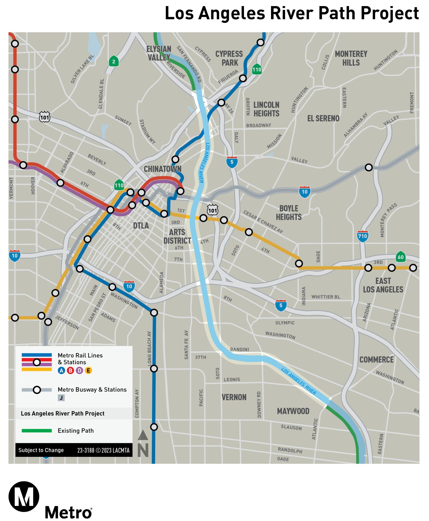
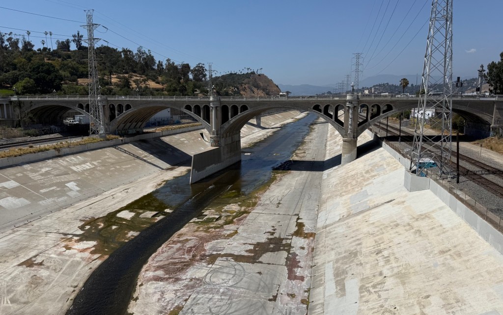
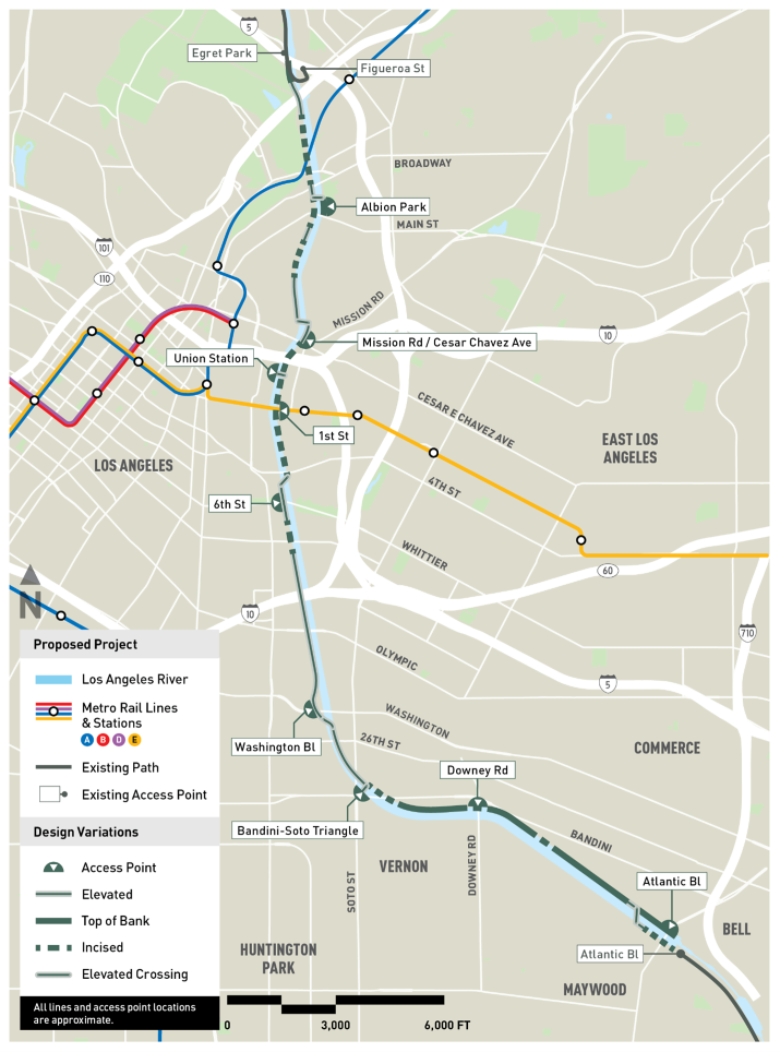
This post focuses on the 8-mile gap in the central city part of the river path – through downtown L.A., Boyle Heights, Chinatown, Lincoln Heights, and the city of Vernon.
Up front, I want to acknowledge that this is not an easy project. If it was simple, the county would have installed a bike path there back in the 1970s. Both sides of the river in downtown and Vernon have lots of existing infrastructure: active rail lines (generally at least four railroad tracks – two on each side), several freeways, power lines, and more. All of that is up against concrete flood control channels where water can rise quickly.
Nonetheless, I think that there are a few big problems in Metro’s approach to this important and complex project.
Who Will Maintain the River Path?
What feels like the thorniest and most fundamental issue is maintenance. The path will not be built until some agency takes responsibility for “O&M” – operations and maintenance.
When Metro expands freeways, the state (Caltrans) maintains them. When Metro expands rail or bus facilities, Metro maintains them. When Metro expands bicycle and pedestrian transportation… it depends.
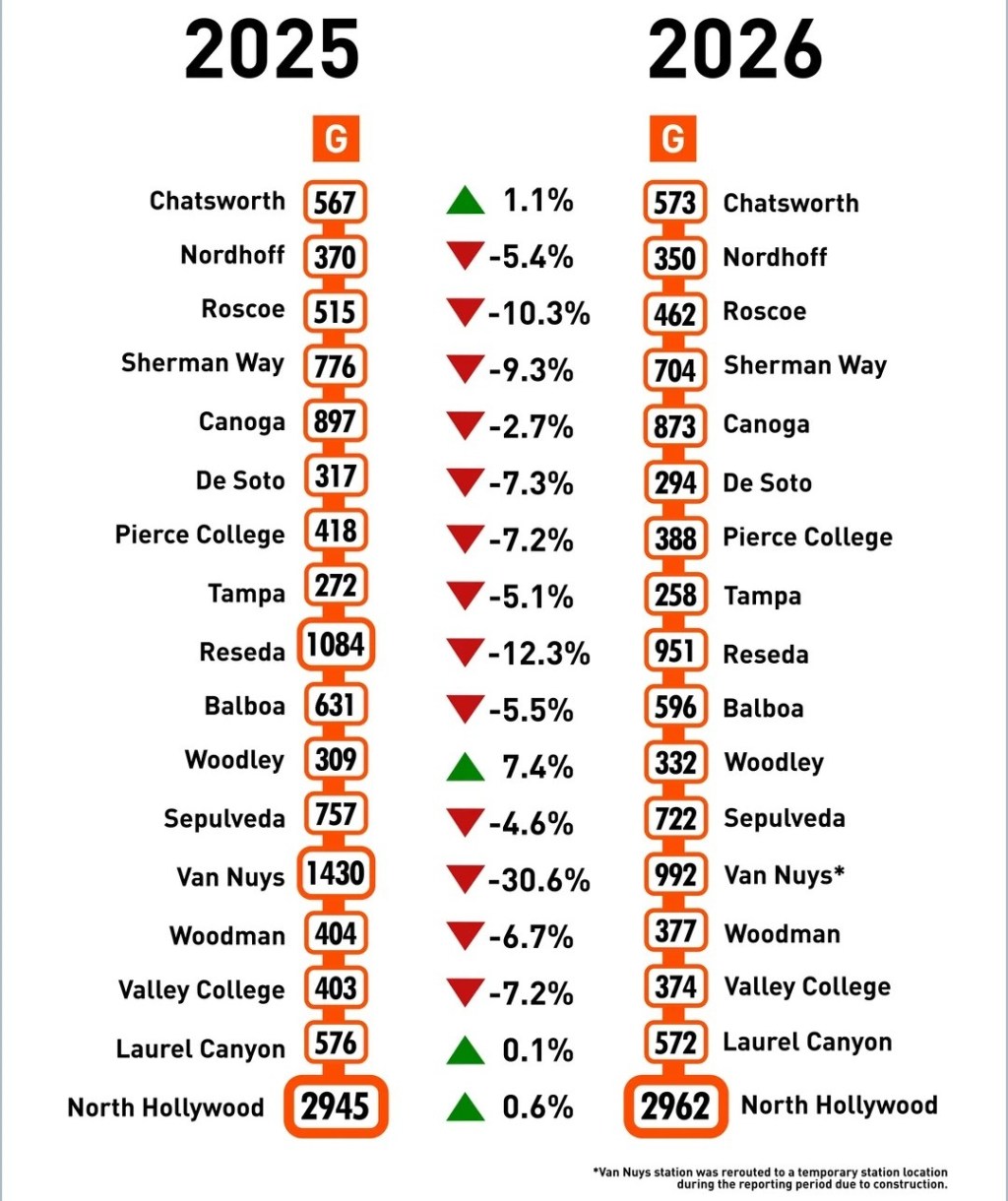
Mostly Metro arranges for other governmental entities to maintain bike paths. For example, in the city of L.A., the L.A. City Transportation Department (LADOT) maintains the parts of the Metro-built E/Expo Line and G/Orange Line bike paths. Santa Monica maintains the E/Expo path there. (The exception that sort of proves the rule is the new Rail-to-Rail path, located in Metro-owned right-of-way, built and maintained by Metro.)
Metro representatives have repeatedly stated that Metro will not maintain the L.A. River path because Metro doesn’t own the right-of-way where it will be built.
In L.A. County, most waterway bike paths are maintained by the L.A. County Flood Control District (which is generally responsible for maintaining the concrete structures encasing local rivers and creeks). In L.A. City, though, the city (LADOT) maintains existing L.A. River path segments, somewhat imperfectly.
Last year, Metro announced that instead of the underlying cities (L.A. and Vernon) or the county maintaining the new river path, Metro anticipates that a not-yet-formed governmental body (a Joint Powers Authority – JPA) would be formed, and would maintain it.
The idea of an overarching river authority is appealing. It’s needed. But it’s likely to take a long time to create – mainly because neither the county nor the cities want to cede any power, or control, or funding. Since the early 1990s, river advocates have unsuccessfully pushed for an L.A. River JPA. I want this, but I expect that any project waiting a river JPA will likely to wait a long time.
My take is that, based on past and current maintenance practices, the easiest path forward would be for the city of L.A. to maintain its part of the path (~5 miles in DTLA) and for L.A. County to maintain its part (~3 miles in Vernon).
A maintenance plan needs to be in place before finalizing design because the agency that will maintain the facility will want to have its say on what they will commit to maintain. If the maintenance partner is brought in at the end of the design process, it often means reopening the design process and reworking plans – meaning more delays.
River Path Design Issues
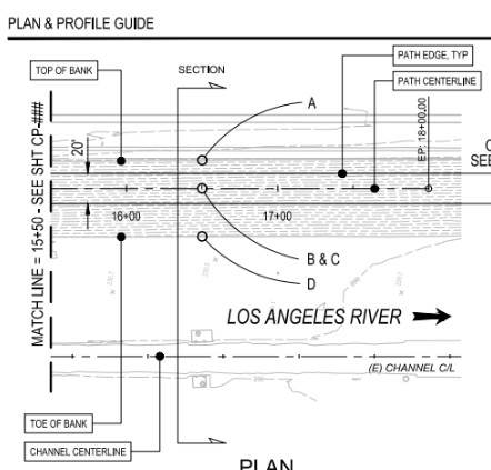
Without a maintenance plan, Metro is now looking to finalize the path design (to approve the project’s draft Environmental Impact Report).
But Metro’s design costs too much.
The basic river path design problem, as I see it, is that instead of a design that more-or-less matches the ~$430 million in hand, Metro included lots of expensive features that Metro can’t afford.
It’s like Metro is a shopper at a store. Metro didn’t look at its bank balance and just threw lots of nice things into its shopping cart. Now Metro has $100 worth of groceries but only $40 to pay for them.
Metro’s river bikeway design costs about a billion dollars, and Metro only has about $430 million for the project.
(To put this in perspective, $430 million is more than the cost of any bike/walk project ever built in Southern California. I suspect a billion dollars may be more than any 8-mile bike project ever built in the United States. My expectation is that, even in a complicated constrained location, $430 million should be enough to build 8 miles of path.)
Metro’s plan-for-more-than-you-can-afford approach more-or-less works for Metro freeway and transit projects because there are significant streams of federal and state funding for freeway and transit expansion. There is some outside funding for bike/walk projects (mostly the state’s oversubscribed Active Transportation Program grants) but it’s not much.
Why does Metro’s planned path cost so much? Let me count the ways.
Metro opted to design a 20+feet wide path.
The impetus for this is good: it allows pedestrians and cyclists to have their own space so cyclists won’t crash into people on foot. But there’s no waterway bike/walk path in L.A. County that is anywhere near this wide. The existing river path segments are mostly 10-12 feet wide – sometimes narrowing to 8-feet in constrained areas. There are a lot of constrained areas in the downtown L.A. river stretch.
A double-wide facility drives the cost up.
What’s optimum width for a shared walk/bike path? I mostly get around by bike, so I have my biases, but I think that 10-12 feet is acceptable. Where space permits, where bike/ped volumes are expected to be higher (maybe near Union Station), perhaps 14-15 feet makes sense. For access ramps and for expensive bridge/elevated/incised areas (more on these below) I think 10-12 feet is sufficient.
At 20 feet, a lot of Metro’s proposed design doesn’t fit into existing at-grade public right-of-way, so Metro proposes quite a bit of above-grade and below-grade path sections. The wider these are, the more expensive they are.
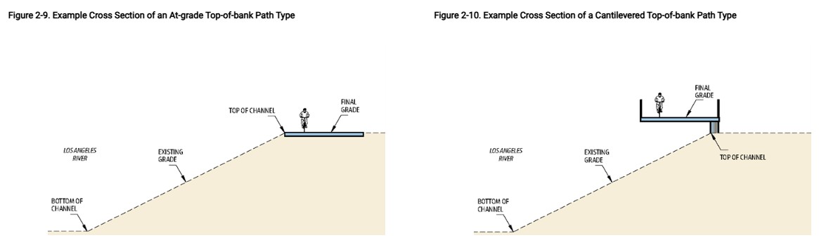
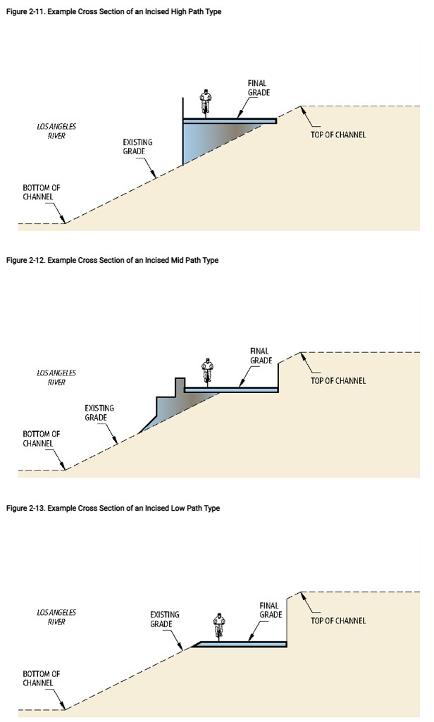
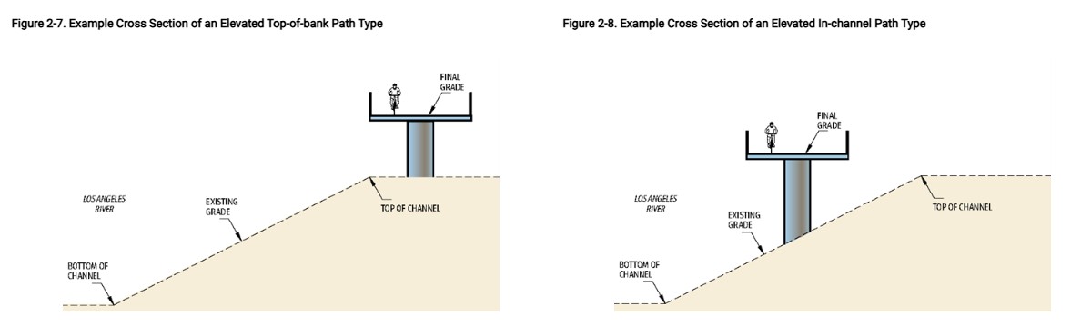

I want to acknowledge that getting the river path through the central city will include some expensive features – likely a couple of bridges, some elevated stretches, several incised stretches (under each bridge at least), several ramps, etc. But I also want to note that making the path 20 feet wide makes more expensive features necessary, and increases the cost of each feature.
Metro’s DEIR design is one-size-size-fits-all 20-feet-wide everywhere. That’s breaking the bank and likely to delay the project indefinitely.
Metro also opted for quite a few access points. The impetus for this is good: more access points means it’s easier for more communities to access the river. I admit, I do like a lot of access points. But I think, to some extent, designing for lots of access points kind of assumes nearby streets will be unsafe for biking and walking. If it’s safe to walk/bike on city streets near/over the river, then perhaps fewer access points are needed.
And there are different kinds of access points – from relatively cheap to very expensive. All planned access points include full 20-foot-wide ramps; many include long and/or short bridges (crossing river and/or railroad tracks), ramps, and more.
Access points involve trade-offs. Definitely the path needs quite a few access points, but including too many costly ones drives up cost excessively.
I recommend trimming a couple of the more costly access points – mainly ones that require expensive new bridges across the river. I do this somewhat reluctantly; I don’t want to omit these forever, but do want to postpone them to a future phase, so that an initial 8-mile phase becomes fiscally feasible.
I encourage folks out there to submit public comment. Here are basic talking points:
- Resolve maintenance issues to minimize later delays. Utilize existing city/county maintenance practices.
- Retool the design to reduce costs, in order to ensure a basic 8-mile gap closure can be built with current funding in hand
- Especially in constrained areas, make the path narrower than 20 feet, preferably 10-15 feet.
- Minimize expensive features: fewer bridges, fewer elevated and incised path segments, and slightly fewer access points. Include more inexpensive top of bank at-grade and in-channel segments.
- Design and pre-approve later phases to include additional access points, with additional bridges
For what it’s worth, I submitted this 6-page comment letter, which includes all of the above points, plus even more in-the-weeds specifics.
Comments are due Monday February 2.
Find the river path Draft EIR, including an interactive version, at Metro’s project webpage. The public can provide comments by mail, email, phone, or at public hearings. There is one remaining public hearing tomorrow – January 31 from 10 a.m. to 12 p.m. at Felicitas and Gonzalo Mendez Senior High School at 1200 Plaza Del Sol E. in Boyle Heights (next to the Metro E Line Pico Aliso Station). Email comments to lariverpath@metro.net.

Read More:
Streetsblog has migrated to a new comment system. New commenters can register directly in the comments section of any article. Returning commenters: your previous comments and display name have been preserved, but you'll need to reclaim your account by clicking "Forgot your password?" on the sign-in form, entering your email, and following the verification link to set a new password — this is required because passwords could not be carried over during the migration. For questions, contact tips@streetsblog.org.