Modest Bike Improvements Along Downtown Connector Stations, Though Mostly Missed Opportunities
There are a few welcome new bike lanes at new Metro Regional Connector A/E Line stations. Mostly though, even these modest improvements fall short of the city’s actual approved street plans.
This continues a disappointing pattern. Metro has omitted approved bikeways from projects ranging from 57/60 Freeway expansion, Rosa Parks Station upgrades, East San Fernando Valley rail, parts of Expo rail, and more. The city of L.A. has failed to add approved bikeways during repaving and when rebuilding bridges.
With the downtown Regional Connector subway stations open, Metro contractors have largely completed finished restoring streets along stations. Many of these streets had been partially closed off for construction for the past decade. The smooth newly repaved restored streets, many widened (more on this below) present opportunities for implementing bike and bus facilities already approved in the city of Los Angeles plans.
This post examines connector station areas east to west.
Little Tokyo Station area
Streetsblog reported earlier on recent First Street bike lanes along the Little Tokyo Station, and extending (eastbound, westbound) over the L.A. River into Boyle Heights. These new lanes are part of Metro’s Little Tokyo/Arts District Eastside Access Improvements. Though a lot of the Eastside Access project appears done, its centerpiece – the Alameda Esplanade – is still a construction site.
Between Temple Street and the 101 Freeway, the esplanade is open, but not looking particularly like an esplanade that will attract anyone walking for pleasure. It’s a decent-width sidewalk with no trees, no shade, between the widened traffic-choked Alameda Street and the fenced-off Connector train tracks. The north end of this section features a slip lane where drivers turn across the esplanade often without slowing down.
Yes, you read that right – a widened Alameda Street. When adding transit stations or esplanades (or housing or retail or whatever), the city of L.A. automatically widens its streets. A recent City Council motion is due to put an end to this harmful street dedication practice… but it’s a theme in today’s post: how L.A. City and Metro teamed up to widen streets at rail stations, making them less conducive to first/last mile trips by bike and by foot.
Broadway Station area
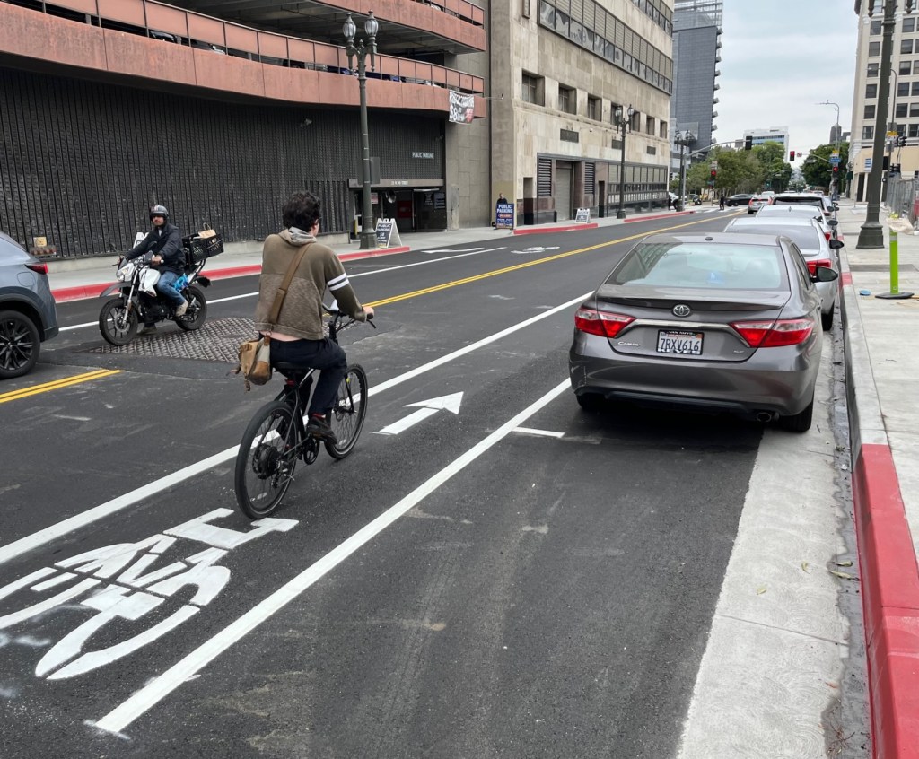
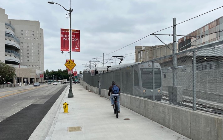
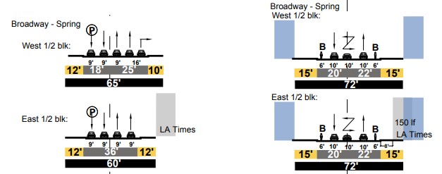
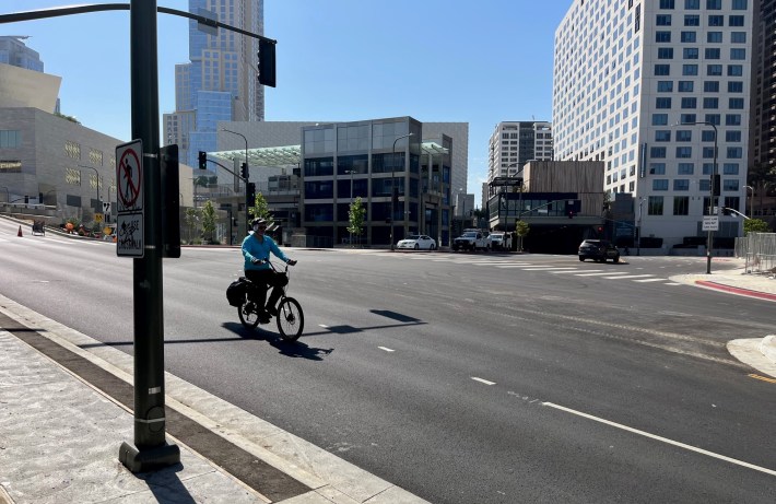
In the past week or so, street restoration has resulted in a couple new blocks of bike lanes, initially noted on Twitter, at the new Historic Broadway Station. There is one new block of one-way eastbound bike lane on Second Street (photo at top of post) between Spring Street and Broadway.
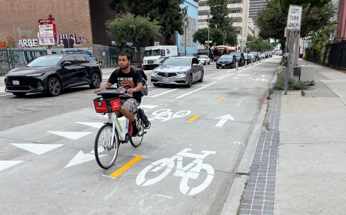
In addition, the two-way protected bike lanes on Spring Street were effectively extended two blocks – with an additional two-way block between 2nd and 3rd Streets, and a new block of northbound counterflow lane between 1st and 2nd Streets. This two-block stretch had had only a southbound unprotected bike lane.
While any new bikeway is better than none, the new 2nd Street one-way lane is just half of what was approved in the city’s plans for this block. In the 2008 Downtown Street Standards, L.A. approved two-way bike lanes (and on-street parking removal) for the station block of 2nd Street .
(Note that these bike lanes were approved in 2008, well before Metro started Connector construction in 2014. Public agencies sometimes claim that they can’t add bikeways because the plans weren’t approved when mega-project plans were finalized long ago. The Second Street bike lanes – and Flower Street below – were approved a half-decade before Metro began construction.)
The city’s 2014 Mobility Plan also included these Second Street bike lanes, and upgraded them to protected bike lanes.
But somehow, in widening and restoring this block of Second, Metro and L.A. City did not follow the city’s own plans, and added just a one-way bike lane.
The Downtown Street Standards, which were heralded as largely ending downtown street widening, approved narrowing the Second Street roadway at Broadway – from 43 feet to 42 feet wide. Instead of following the city’s narrowing plan, Metro and L.A. City widened this part of Second Street to 46 feet. Instead of adding a two-way bike facility, Metro and the city preserved on-street parking directly in front of the new station – on-street parking that the city approved eliminating back in 2008. Yes, you read that right: the city ignored its own plan, widened a street it was supposed to narrow, and prioritized on-street parking over a first/last mile bike connection – all directly in front of a rail station.
(The width varies on that block of Second. The roadway is narrower close to Spring. At Spring, the Regional Connector construction widened Second from 36 feet to 42 feet. There the current roadway width matches the city’s plan, but the lane striping does not.)
Grand Avenue Station area
Last year Streetsblog reported on how Metro construction had widened Second Place directly in front of Grand Avenue Station. That block was a 4-lane street about 50 feet wide; it is now 5-6 lanes and 72 feet wide.
Now that the station is open, it has become clear that the construction also widened and reconfigured Flower Street (along the west side of the station), omitting the bike lanes approved in the city’s Downtown Street Standards and Mobility Plan. At the station intersection, the upper roadway of Flower was widened from 33 feet to 35 feet, with an added left turn pocket expanding two lanes to three. The lower roadway there (sometimes labeled Hope Street) remained 24 feet wide, but went from one lane to two lanes, effectively using up the space the city had designated for a bike lane.
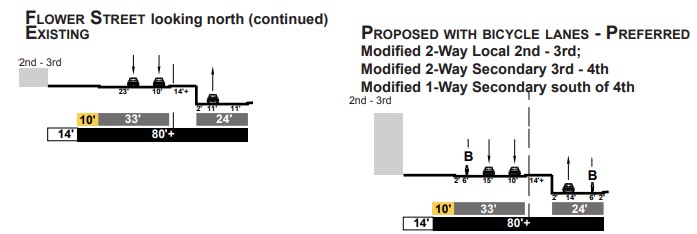
Immediately south of the Grand Station, Metro construction combined two lower roadways into a 33-foot wide two-lane road (which widens to 36 feet to add a turn lane at 2nd Place). The street striping doesn’t just ignore the approved bike lane, but – by putting a striped buffer along the center median – pushes drivers out into the space where slower moving cyclists are bicycling uphill to get to the station.
It’s as if the agencies decided to not just ignore the planned bike lanes, but instead widened and striped streets in ways that would be most hostile, most dangerous for cyclists.
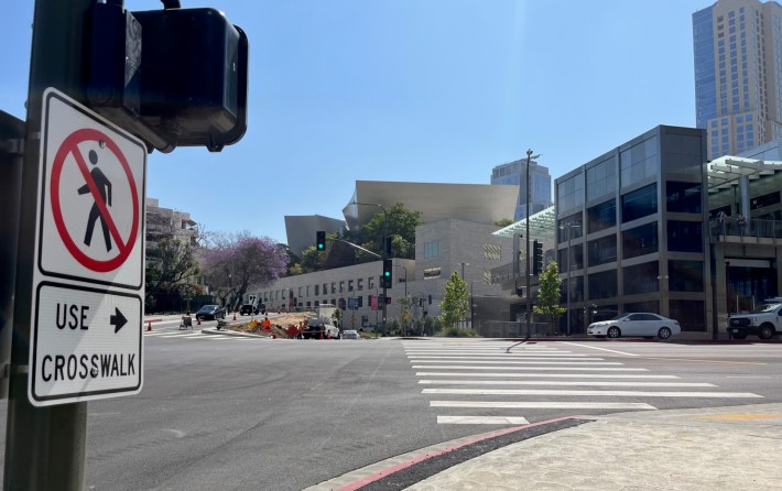
At street level, the Grand Avenue Station is an island in a sea of car-centric design. Impatient drivers speed along widened curved freeway-ramp-like streets, then, at intersections, queue into multiple turn lanes that make it difficult to see transit riders on foot and on bike.
The station bike racks are the only trace of anything that acknowledges the existence of cyclists. Pedestrians are forced to put up with beg buttons and missing crosswalk legs (an unfortunate L.A. City standard), and another downtown slip lane at the bottom of the hill.
It feels like the assumption is that nobody will ever bike or walk at street level; everyone who ever uses this station will cross the bridge to Grand Avenue. That bridge wasn’t designed with bicyclists in mind. Cyclists and pedestrians are already accessing this station at the ground level, and Metro and L.A. should expect that. Station area street design should welcome these riders, and should keep them safe.
5th Street at Flower
And there is one additional bus lane feature coming a couple blocks south of the Grand Station: a bus lane queue jumper on 5th Street at Flower. Metro announced this bus speed improvement back in mid-2020. At that time, queue jumper installation, waiting on Regional Connector street restoration, was tentatively expected in Spring of 2022.
With Flower Street street restoration is basically done, Streetsblog inquired as to the timeline. In late May, Metro Communications Manager Patrick Chandler responded that the 5th/Flower queue jumper “is in the design phase” with construction now anticipated in early 2024.

Read More:
Streetsblog has migrated to a new comment system. New commenters can register directly in the comments section of any article. Returning commenters: your previous comments and display name have been preserved, but you'll need to reclaim your account by clicking "Forgot your password?" on the sign-in form, entering your email, and following the verification link to set a new password — this is required because passwords could not be carried over during the migration. For questions, contact tips@streetsblog.org.