The Metro board has a big decision this month: will they accelerate construction of the agency's SR-57/SR-60 Interchange Improvements Project? Specifically, the Metro board faces a vote on approving the 57/60 Life of Project budget (LOP) which would mean greenlighting the main phase of project construction.
The $400+million 57/60 expansion project is located in the eastern San Gabriel Valley city of Diamond Bar. For about two miles, the 57 and 60 Freeways converge resulting in a congested trunk stretch. Caltrans, Metro, and many elected officials have pushed freeway expansion there as a fix for the traffic congestion. Voters approved $205 million in Metro Measure M sales tax funds scheduled for a 2025 57/60 widening groundbreaking.
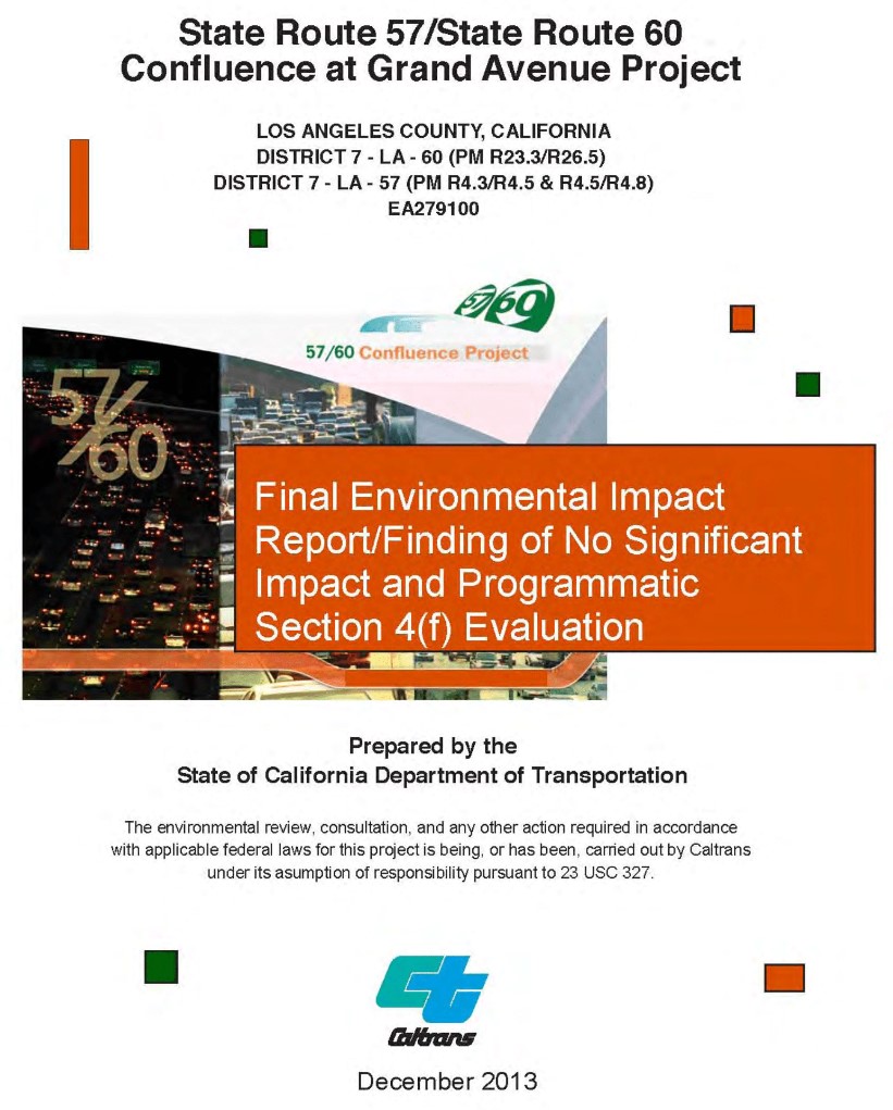
The project was environmentally cleared back in 2013; see its FONSI - Finding of No Significant Impact. Unfortunately, the decade-old design has a lot of problems. Some of the problems are inherent to Metro's approach to freeway expansion, but some of the project flaws could be resolved by a timely redesign. For these reasons, the Metro board should not approve the 57/60 project as currently designed.
1. All freeway expansion induces more driving, more congestion, more pollution including more greenhouse gas (GHG) emissions
At its core, the 57/60 project is about adding one more lane.
Specifically, the project would widen the freeway roadbed to add one more eastbound general purpose lane - just over two miles long. In addition, the project adds several new on- and off-ramps (two of them are extended bypass structures), widens other ramps, and widens nearby surface streets.
There is a lot wrong with this antiquated approach to freeway widening; it has always resulted in more traffic, more congestion, more pollution, more global warming, more noise, etc.
Additional lane miles induce more driving. Between the additional 57/60 freeway lane and new and widened ramps and streets, the project would add at least eight new lane miles. According to the UC Davis calculator, this expansion would generate 65+million additional vehicle miles traveled (VMT) per year, resulting in ~30,000 tons of greenhouse gas emissions annually.
2. Much of the project was designed to serve a never-built Grand Crossing NFL stadium
Back in 2008 (see LAist and L.A. Times accounts) developer Ed Roski proposed a 75,000-seat stadium on a 600-acre City of Industry site along Grand Avenue immediately west of the 57/60 Freeways confluence. The $800 million Grand Crossing stadium would have had a "vast entertainment zone complete with a wave pool you could surf in, and overhead sky buckets traversing the site." A handful of potential stadium sites were jockeying up until around 2014, with Inglewood ultimately landing the NFL team.
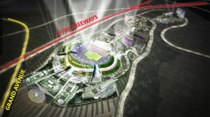
Grand Crossing stadium complex was never built. But its plans for Grand Avenue still permeate the freeway expansion proposal before the Metro board this month. Several major components of Metro's 57/60 project design focus on getting stadium car traffic onto and off of Grand.
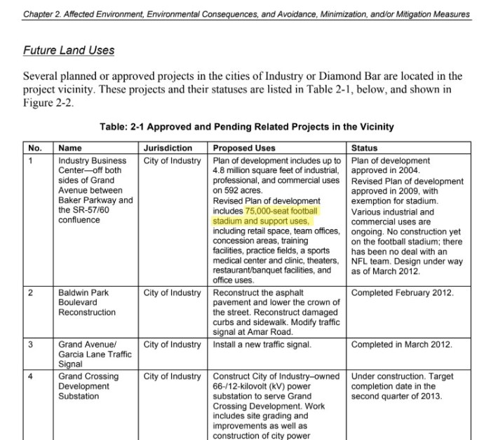
The proposed stadium tops the 2013 57/60 FONSI analysis of future land uses. The "future stadium," including analysis of its construction and traffic impacts, is mentioned dozens of times in the FONSI document.
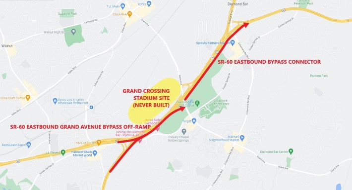
To serve stadium traffic on Grand Avenue, the project includes two long flyover/bypass structures: (descriptions from Metro project storymap webpage)
- SR-60 Eastbound Grand Avenue Bypass Off-ramp: A mile long, two-lane ramp that begins immediately after the Southbound SR-57 diverge, crossing over the northbound SR-57 lanes to exit Grand Avenue.
- SR-60 Eastbound Bypass Connector: A half-mile long elevated bypass for northbound SR-57 and Grand Avenue eastbound on-ramp traffic to cross over Diamond [Bar] Boulevard and eastbound on SR-60.
Note that the bypass ramps don't actually bypass the congested trunk. They get drivers onto and off of Grand Avenue, located right in the middle of the congestion.
Why build elaborate expensive bypasses just to serve a stadium-less Grand Avenue? Grand does serve some destinations - strip malls, industrial warehouses, Mount San Antonio College, and Cal Poly Pomona - but, especially to the southeast (where the 57/60 project is widening roads) Grand mainly serves a suburban residential area. With the stadium plans long canceled, should Metro still cling to plans for spending tens of millions on bypass ramps to serve drivers using Grand?
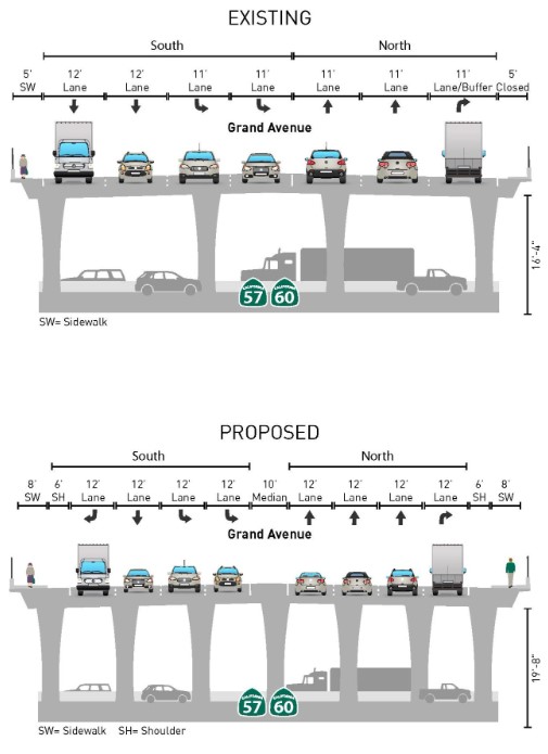
The project also replaces the Grand Avenue bridge over the 57/60. The existing 72-feet roadway bridge would be widened to 118 feet, with new and widened ramps from Grand onto the 57/60 bottleneck. This street widening perhaps made some sense when the project was anticipated to serve a stadium located on Grand Avenue a block northeast of the freeway, but it might not make much sense now. If the project goal is to reduce congestion on the main congested freeway trunk, widening Grand could be counterproductive, as a wider Grand would more quickly funnel more car traffic into the middle of the bottleneck, likely to result in increased congestion there.
Metro should pause and reevaluate the portions of this project that focus on getting drivers to Grand Avenue's imaginary stadium.
3. Metro should follow its voter-approved timeline, not accelerate highway expansion
In 2016, L.A. County voters approved Metro's Measure M sales tax, which included a detailed year-by-year expenditure plan for specific projects. The expenditure plan programmed $205 million for SR-57/SR-60 Interchange Improvements scheduled for a 2025 project groundbreaking. This month, the Metro board is voting to accelerate funding for the 57/60 - with a 2023 groundbreaking.
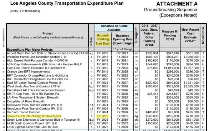
Often the Metro highway program (when justifying massive freeway budget increases) representatives state that the Metro is "locked in" to freeway expansion because it's "what voters approved." But in this case, it's definitely not what voters approved, and it's not locked in until the Metro board approves the budget.
The Measure M expenditure plan shown above makes it clear that accelerating the 57/60 would allow it to jump the queue ahead of many other projects Metro had scheduled for earlier groundbreakings, including NoHo-Pasadena Bus Rapid Transit (2020), West Santa Ana Branch rail (2022), two L.A. River bike/walk paths (2023), Sepulveda Transit Corridor (2024), Vermont Bus Rapid Transit (2024), and even extending the Gold Line through Pomona and Claremont to Montclair (2019, first phase underway). Why is Metro accelerating harmful freeway widening ahead of bus, rail, and active transportation?
There are separate Measure M funding streams for transit vs. highway, so accelerating a Measure M expenditure for a freeway expansion project does not directly compete with transit projects. But there are indirect effects. Most Metro megaprojects encounter cost overruns and end up drawing down some flexible money, often money that could go to other modes (in some cases including transit operations). Locking in accelerated capital projects, and their ballooning budgets, has been characterized as "sucking the air out of the room" for other Metro priorities, including transit.
Even in the Measure M "highway" mode funding (right column labeled "H" in above chart), there are several worthwhile "highway" category projects that the 57/60 would be jumping ahead of. Two 2023 L.A. River path projects are in the "highway" category and would be pushed behind the 57/60. There is also the highway category High Desert Multi-Purpose Corridor, now slated to be high-speed rail, which was scheduled to have property acquisition underway in 2019.
It seems pretty clear that Metro is eager to accelerate freeway widening, while letting non-freeway project schedules slide. The Metro board needs to end this harmful biased practice. Perhaps the board should direct staff to get all of the Measure M 2018-2024 groundbreakings done first (maybe at least those listed in the "highways" category?), before proceeding with the 57/60 widening's 2025 groundbreaking.
4. The project's 2013 environmental clearance is outdated, and should be revisited
Metro and Caltrans approved the 57/60 expansion designs back in 2013.
A lot has changed since then.
In 2013, atmospheric carbon dioxide was about 390 parts per million; in the ensuing decade that number grew to 419 parts per million. (The 57/60 2013 FONSI has a perfunctory cut-and-paste section on climate change, concluding "Caltrans has determined that in the absence of further regulatory or scientific information related to greenhouse gas emissions and CEQA [California Environmental Quality Act] significance, it is too speculative to make a determination regarding the significance of the project’s direct impact and its contribution on a cumulative scale to climate change.")
California's environmental clearance processes have changed a great deal since 2013. For analysis of traffic environmental impacts, California replaced the discredited level of service (LOS - which appears throughout the 57/60's 2013 FONSI) with a more climate-focused metric of VMT - vehicle miles traveled. Metro and Caltrans have adopted new policies that theoretically move the agencies away from car-centric freeway expansion. Caltrans adopted a complete streets policy in 2021. Metro adopted policies supporting complete streets (2014) and equity (2018), and affirmed flexibility for highway projects to support multi-modal transportation (2021). But the agencies are still trying to build the 57/60 design approved in 2013.
Metro's 2020 57/60 project fact sheet noted that Metro had to "revalidate" the 2013 FONSI:
The SR-57/SR-60 Confluence Project’s environmental phase was completed in 2013. As part of the Plan, Specification and Estimate (PS&E) phase, the report needs to be reviewed and updated to reflect changes to current conditions since its completion.
This improvement project will reassess existing conditions and regulations previously identified by the SR-57/SR-60 Confluence Project, as well as identify opportunities for minor design improvements based on changes in the area. In addition to an environmental revalidation, the project will prepare an updated project report. The PS&E phase is scheduled to be completed by the end of Summer 2021.
Then, last year, Metro's project storymap website listed a bare-bones schedule stating that "Environmental Revalidation" was "Completed June 2021."
Beyond those five words on that website, though, Metro has made no information, no "updated project report," no documents, no nada publicly available regarding any outcomes of its revalidation process. Was anything "updated to reflect changes to current conditions"? Were any "minor design improvements" identified?
If Metro and Caltrans significantly revised their 2013 design, then they should have filed new environmental documents with the state. The state would then make the documents public by posting them at the California's CEQA database. The state database shows no 57/60 environmental documents more recent than 2014. (The 2014 NOD is the state's Notice of Determination, accepting Caltrans' 2013 FONSI.)
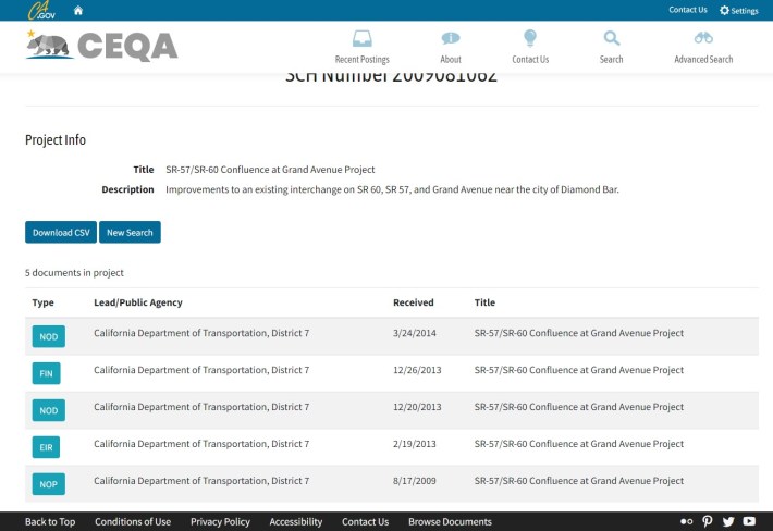
There are no recent revalidation documents posted at Metro's project pages (neither the storymap nor Metro.net, which does have a 2015 federal revalidation document), nor at the San Gabriel Valley Council of Governments (SGVCOG) project page. Caltrans District 7 website does not have the 57/60 among its current projects.
In April 2020, Streetsblog requested that the SGVCOG and Metro provide documentation of the 57/60 environmental revalidation process. In December 2020, Streetsblog filed a California Public Records Act request for revalidation documentation, but no documents have been released at the time of publication.
Did Metro actually do any serious project reevaluation circa 2020-2021? Hard to tell. If so they apparently did it behind closed doors, with no public-facing process, no publicly accessible documentation, no posts to social media (neither Metro's nor the project Instagram, Facebook, or Twitter accounts), nothing at Metro's the Source, no documented discussion at SGVCOG committees. Nothing.
The current designs (on Metro's storymap) do not appear to differ from the design in the 2013 FONSI.
Again, a lot has changed since 2013. It's time for Metro and Caltrans to pause this freeway widening, and reassess what in their 2013 design still makes sense.
5. The 57/60 project continues a bad precedent of expanding freeways by taking public parkland
Metro and Caltrans plan to widen the 57/60 interchange at the expense of public parkland, specifically on land that is L.A. County’s Diamond Bar Golf Course. The public would lose 9.1 acres of park land; the course would shrink 5 percent – from 171.3 acres to 161.9 acres. In addition to a reduced footprint, the golf course would suffer from increased noise and pollution of being next to an expanded freeway, including new on- and off-ramps though what was formerly golf course land.
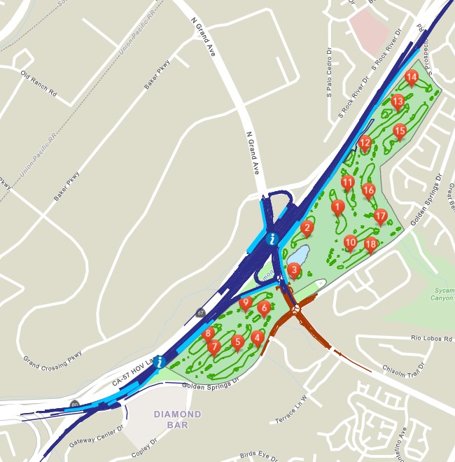
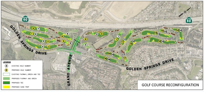
The initial $91 million golf course reconfiguration phase is already under construction; the course has been closed for construction since September 2021.
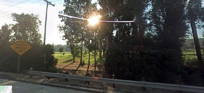
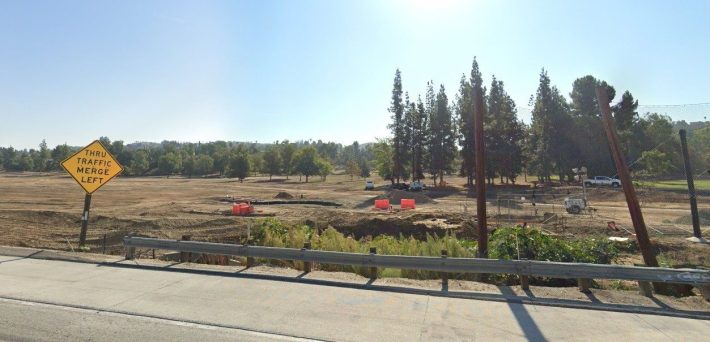
The golf course phase actually has its own environmental clearance documents - an MND (mitigated negative declaration).
(There may be a breach of environmental law here. Though various documents, for example this fact sheet, make it clear that the golf course is "part of planned freeway improvements," and the golf course work resulted in an MND, Metro and Caltrans still assert that the overall project has "no significant impact," hence their FONSI environmental clearance. If a subcomponent of this project requires mitigation - a higher standard than a FONSI, how can the overall project be cleared with a FONSI?)
From Hollenbeck Park to Griffith Park, Southern California has a history of degrading parks by putting freeways through them. That destructive tradition continues today.
Metro and Caltrans are currently widening the 405 Freeway, adding more traffic directly alongside La Carretera Park in Torrance. Metro and Caltran's nearly-completed lower 5 Freeway widening took portions of Norwalk Park and Sara Mendez Park. Metro's 91 Freeway widening plans to remove "slivers" of Artesia's A.J. Padelford Park, and Cerritos' Ecology Park (that project's FONSI envisioned taking much more of Ecology Park by widening Gridley Road through it, but the city of Cerritos declined). Metro's 605 Freeway Corridor Improvement Project proposed impacting several freeway-adjacent parks, including removing a large chunk of Downey's Dennis the Menace Park next to the 5 Freeway.
Should the public be up in arms about Diamond Bar Golf Course sacrificing nine acres? Perhaps not in and of itself... but at some point, Metro and Caltrans need to reconsider their ongoing degradation of public parklands, instead of continuing to blithely deny degrading parks as "no significant impact."
6. The project omits much of Diamond Bar's planned bikeways
Recently Metro has begun to tout the 57/60 project's "multimodal elements." In an email to Streetsblog, Metro spokesperson Patrick Chandler asserted that the "57/60 Project is in alignment with the Metro Board-adopted Multimodal Highway Investment Objectives." But the project's miniscule bike/walk components do not appear on Metro websites, apparently having recently been added to the project. The bicycle component of the project even falls short of complying with approved local bike plans.
In 2019, the city of Diamond Bar approved its General Plan 2040. Among the plan's guiding principles is to "Improve mobility... by providing a diversity of safe and convenient transportation options in a cohesive network, including active transportation, transit, and automobile facilities."
The plan maps existing and future bikeways as part of the city's bicycle network.
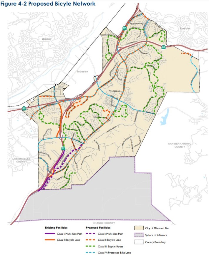
Within the footprint of the 57/60 widening project, Diamond Bar approved protected bike lanes on both Golden Springs Drive and Grand Avenue.
Golden Springs and Grand widening is already under construction, as an early phase of the 57/60 project. The $16.8 million Grand Avenue and Golden Springs Drive Improvement Project got under construction in late 2020, with an expected completion this year. The street project was funded by Metro ($6.8 million) and the city ($10 million). Grand is being widened from ~82 feet to ~101 feet. Golden Springs is being widened from ~64 feet to 85 feet.
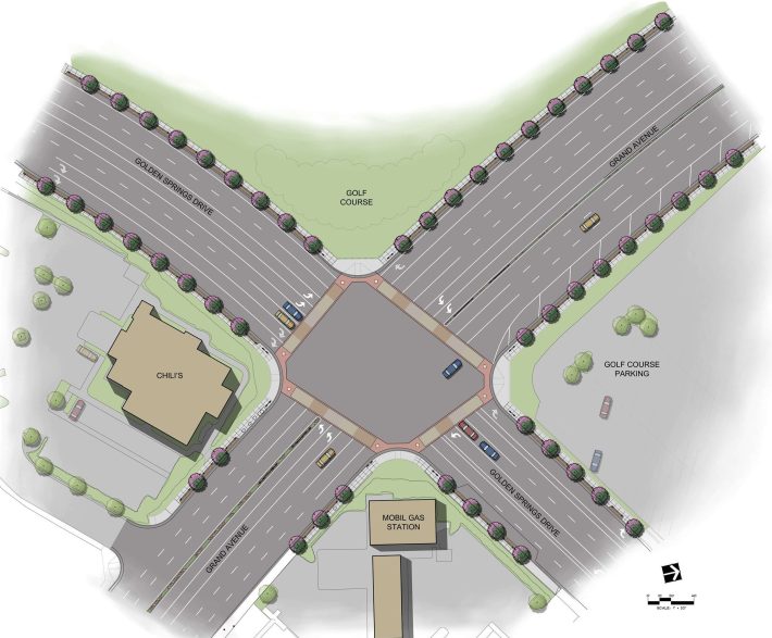
Grand/Golden Spring project descriptions show no protected bike lanes. In December, Streetsblog inquired to the city as to whether bike lanes were included in the project, but received no response.
So, the early under-construction phase of the project fails to implement the city's bike plan. (This could and should be remedied by a relatively inexpensive change order - similar to what Caltrans is doing in Burbank.) This shortfall is perhaps attributable to the 2019 Diamond Bar General Plan and the 57/60 project early street phase designs being finalized around the same time.
But what about the next phase of the 57/60 project? That phase includes widening the Grand Avenue bridge from 72 feet wide to 118 feet wide.
According to the Metro project page, the SR-57/SR-60 Interchange Improvements Project "completed final design in Spring 2022." That's more than a year after the Diamond Bar bike plan's December 2019 adoption. Metro's final project should include those approved protected bike lanes, right?
Metro's 2021 diagram of the planned Grand Avenue bridge shows no bike lanes.
In a presentation last month, Metro announced that the 57/60 project "includes improvements to local... sidewalk and bicycle facilities."
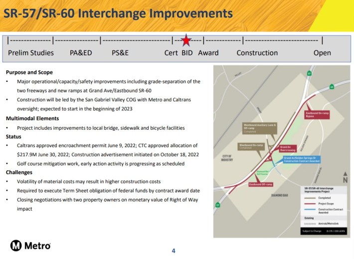
Streetsblog inquired to Metro and the SGVCOG regarding what "bicycle facilities" are included. Metro spokesperson Patrick Chandler responded that Metro "added bike lanes on Grand Avenue from the WB [westbound] off-ramp down to the EB [eastbound] on-ramp... within Caltrans right-of-way." That appears to be about ~600 feet of bikeway, just on the widened bridge (but that's a guess because these bike lanes are not depicted or documented anywhere online.) Last week, Streetsblog asked Chandler if the lanes were protected or not, and Chandler did not respond to the question.
The project also widens the bridge's sidewalks from 5 feet to 8 feet.
To understand Metro's modal priorities, compare that ~600 feet of bikeway (and widened sidewalk) to about 8 miles of new lanes for cars.
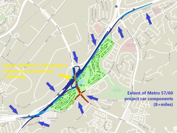
No matter how Metro tries to spin this project as "multimodal," Metro is continuing to heavily prioritize one mode: driving.
Protected bikeways on Grand and Golden Springs may be a minor component of the overall freeway megaproject. But, before approving the 57/60 project budget, the Metro board should insist that the project design include all of Diamond Bar's approved bike facilities. Not just a sad isolated "bridge to nowhere," but full city-approved connected protected bikeways on both Grand and Golden Spring, on the bridge over the freeway and within the project both north and south of the freeway.
