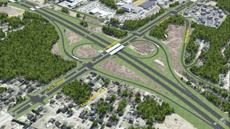
In this year's installment of its annual "Highway Boondoggles" report, Gideon Weissman of Frontier Group and Matthew Casale of U.S. PIRG Education Fund deliver a stark warning about the billions of dollars states spend on unnecessary highways that fracture our cities, deprive transit of scarce funds, and pollute our environment. Below is the first of nine installments detailing case studies of these harmful roadways: North Carolina’s plan to complete the southern half of a loop highway around Raleigh, which would generate sprawl while destroying wetlands and threatening endangered wildlife.
North Carolina transportation officials are moving forward with plans for a new six-lane highway around the southern half of Raleigh that would cause sprawling development and troubling environmental damage. The plan is called “Complete 540,” and would form the southern half of Raleigh’s 540 beltway, approximately seven miles from downtown Raleigh. At a cost of more than $2 billion, the highway, likely to be paid for with a mix of state funds and toll revenue, will be the most expensive in North Carolina history.
According to the Southern Environmental Law Center, Complete 540 would encourage “unplanned growth to sprawl out of Raleigh and into Southeast Wake County.” Those changes would be consistent with the impacts of other bypass highways around U.S. cities, including in the Southeast. A 2000 study, Economic Impact of Freeway Bypass Routes in Medium Size Cities, concluded that negative impacts of bypass routes “include increases in sprawled, low-density commercial and residential development entailing high environmental and infrastructure costs.” That study included an assessment of the I-295 bypass around Richmond, Virginia, which found that “relocations of retailing, local industries, offices, and residents facilitated by the outer belt have weakened the city's downtown business district. . . Without the bypass, local planners agree there would have likely been more redevelopment at high densities in the downtown area.”
Even in the suburban towns it is meant to help, the state has concluded that Complete 540 “would have negative impacts on existing neighborhoods.” The highway will bisect at least two neighborhoods, Woodcreek and Deerfield Park, and cut through land owned by six churches. It will also cross over the scenic Neuse River Trail, “a 28-mile pedestrian and bicycle path that is part of Raleigh’s Capital Area Greenway System.”
Environmental groups have raised extensive concerns and filed legal challenges over the project’s environmental impacts. According to the environmental law center, Upper Neuse Riverkeeper, the Center for Biological Diversity, and Clean Air Carolina, which jointly filed complaints against the project, it will “pave over 70 acres of wetlands, destroy more than 55,000 feet of streams, and cut through the area’s few remaining green spaces.” The project will also destroy critical habitat for federally listed threatened mussel species. In an attempt to compensate for the potential devastation of a threatened species, the state has proposed spending $5 million to grow mussels in a lab for five years.
The highway expansion conflicts with North Carolina Governor Roy Cooper’s commitment to fight climate change. In October, 2018, Cooper signed Executive Order 80, committing North Carolina to reduce greenhouse gas emissions by 40 percent and meet the targets established in the Paris Climate Accord. According to a state estimate, the highway would increase driving by more than 484 million vehicle miles traveled in 2040.
