Note: GJEL Accident Attorneys regularly sponsors coverage on Streetsblog San Francisco and Streetsblog California. Unless noted in the story, GJEL Accident Attorneys is not consulted for the content or editorial direction of the sponsored content.
Before cities can make streets safer, they need good data on collisions--and that data has to be collected well, processed well, and easily accessible to transportation planners, explained Timothy Black with the Los Angeles Department of Transportation. But, until recently, the department lacked those capabilities, "...despite being a department full of engineers, we were still looking at a mishmash of pdf docs and spreadsheets."
Black made that point during a panel discussion today at SPUR's San Francisco location about the necessity for cities to master data as a first step towards achieving Vision Zero. "Can we ask good questions from the data and pull insights?"
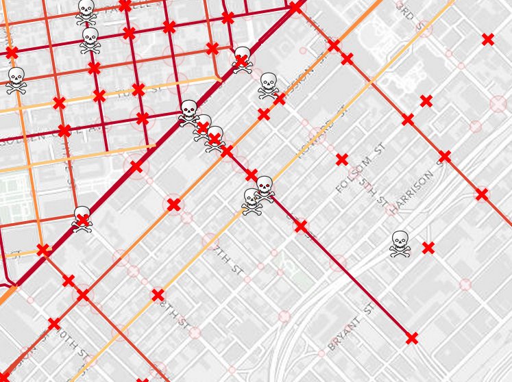
The challenge for Los Angeles, explained Black, was to take crash reporting information, collected by the police, and overlay it with geographical data, so traffic engineers could actually find and identify trouble spots. "The crash data wasn't geo-coded in a way that could be quickly analyzed. The first major task was to streamline this process."
Los Angeles hired an outside contractor and can now update heat maps of the city with data that includes crashes that are only three months old, instead of a year and a half old. This helps engineers adjust on-the-ground infrastructure such as crosswalks and traffic lights with more real-time feedback.
It's one thing to know where crashes are happening. But it's equally important to know what kind of infrastructure they're dealing with. "A few years ago, if you had asked what kind of striping does the crosswalk have at the intersection of Hollywood and Western, we couldn’t tell you that." But now they can, and they can start to figure out what kind of treatments are working and what kinds aren't.
"When Seattle started out pursuing Vision Zero we had limited funding for safety projects," said Darby Watson with the Seattle Department of Transportation. So without proper data sets, Seattle traffic engineers had to resort to just looking at which intersections had the most crashes, with little other criteria. "Road diets were done by ambulance chasing." As she described it, a couple of crashes would happen on one street, so they'd fix it, and then it would happen on another street, so they'd fix that, but the city wasn't yet figuring out what kind of conditions were actually presenting the biggest dangers so they could fix them pro-actively, to prevent crashes instead of just responding to them. "We needed a predictive model of where we have to do the work."
And after 2007, the city started to up its game towards that goal of better interpreting data. They got lots of complaints about bicycle "dooring" crashes from cyclists, but when they dug deeper, they found there were far more injuries and fatalities from left-hook crashes. She recalled that people complained about the lack of real sidewalks on a major arterial, but the pedestrian deaths were actually happening at intersections, not from people getting hit while walking along the road.
"Look at the collision history--where is it possible for it to happen? Where are potential crashes going to happen?" said Watson. In other words, instead of connecting crashes to specific locations (although that's done) it's more important to generalize crash data to bad designs and then "identify locations where street or signal design changes are needed... that helps us make informed decisions about prioritizing safety improvements, by proactively treating locations with the intention of mitigating potential crashes."
Megan Wier with the San Francisco Department of Public Health said San Francisco's approach to Vision Zero is to look at traffic violence as an epidemiological problem, rather than just a traffic problem. "The traditional approach was to accept deaths as inevitable and to focus on individual behavior. Vision Zero is focused on the idea that traffic deaths are preventable and they're too costly to allow."
Traditionally, safety information was gathered by looking at police reports, as Los Angeles apparently still does. But San Francisco, in that epidemiological approach, worked from the treatment end--and tracked injuries and deaths from the trauma center end of things. Police data lacks certain information, such as whether a victim is disabled. "Because of this gap in the data SFMTA funds a Vision Zero epidemiologist, and we partner with Zuckerberg General Hospital," she explained. This allows the partnering agencies to create "...a linkage between police and hospital data, using clinical information from hospital records." This gives San Francisco a better idea of which populations are most vulnerable to traffic violence and the severity of injuries in different locations and different populations.
From this, they realized seniors are significantly more vulnerable. "Seniors are 50 percent of pedestrian deaths. They are five times more likely to die in a crash." That means to achieve Vision Zero, traffic engineers have to prioritize streets in areas frequented by seniors, such as near elder-care facilities.
The results: "We’re happy to learn in 2017, we had our lowest number of deaths in 100 years," said Weir, explaining that the city traffic death rate had fallen from about 30 a year to 20. "But it's too early to declare it a trend." That means the work has to continue, but San Francisco's methods seem to be making some progress, considering population is rising and other parts of the Bay Area--and most of the country--are continuing to see traffic deaths increase, not decrease.
In response to an audience question about how Uber and Lyft help--or hinder--Vision Zero goals, Watson said Seattle "...has a partnership with Lyft to offer discounts on big holidays...and we promote them at local drinking establishments." Another audience member asked if they look at non-collision data, such as the level of sidewalk bike riding (which is legal in Seattle) as an indication of poor bike infrastructure.
At the end though, the panelists seemed clear that the "data" isn't really about numbers. It's about people. "Pedestrians and cyclists are 40 percent of the fatalities, even though they're only 7 percent of the collisions," said Watson. "These aren’t just numbers, they are people, they are families, friends, colleagues, brothers, and sisters, and we have to keep that in mind when looking at the data."

For more events like these, visit SPUR’s events page.
