Metro Awards Contract for Environmental Study and Design of Phase I of Rail-to-River Bike Path
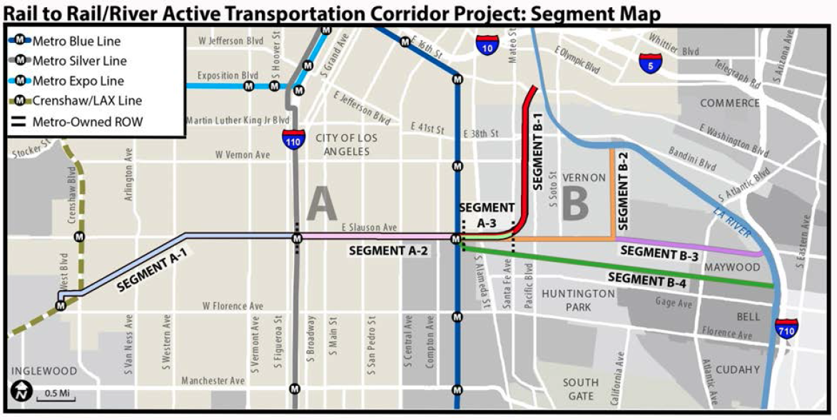
As bike month comes to a close, we have some good news for South L.A. cyclists. At yesterday’s Metro Board meeting, a $2 million contract was awarded to Cityworks Design to begin working on plans for a 6.4 mile segment of the Rail-to-River bike path project (segments A-1, A-2, and A-3, above).
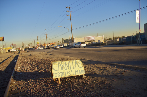
The Rail-to-River bike path, as County Supervisor and Metro Board Chair Mark Ridley-Thomas described it last October, is an important opportunity to turn an 8-mile stretch of a “dormant” and “blighted” rail right-of-way (ROW) in a “historically distressed area” into a biking and walking path that could more efficiently connect people to transit while also bettering the local economy, health outcomes for residents, and the local environment.
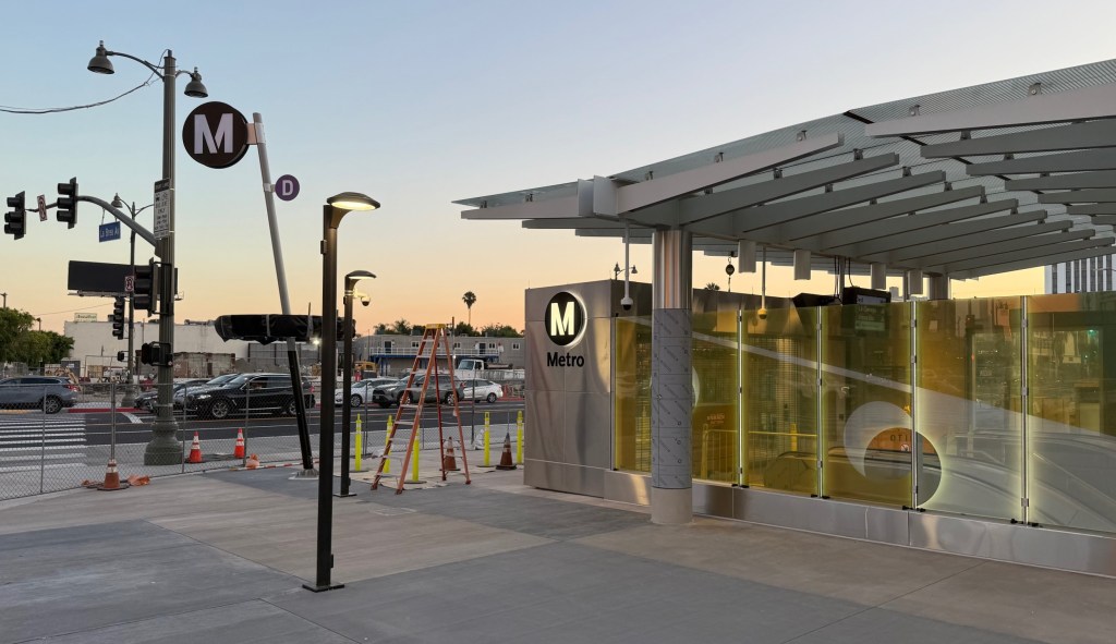
Running between the Crenshaw/LAX Line station at Fairview Heights station to just east of the Blue Line station at Slauson and, in subsequent phases, to the river, the path will not only help connect cycling commuters to transit but offer the local residents of a neglected industrial corridor much-needed green space and a place to safely stretch their legs.
Yesterday’s development doesn’t mean the project is about to break ground, unfortunately. Instead, Cityworks Design has been tasked with undertaking environmental review, clearance, and design work for the project. Supporting documents describe Cityworks as specialists in environmental clearance and able to work within the time constraints of the project. Which is a good thing, as the TIGER grant requires the funds be obligated by September of 2017 and expended by 2022.
The project has been a few years in the making.
It was first proposed in September of 2012, in a motion by Ridley-Thomas and then-Boardmember Gloria Molina.
The few members of the public that attended an open house in late 2013 intended to showcase the feasibility study that was underway got a first look at what the project might entail. When I raised concerns at a follow-up meeting that very little outreach had been conducted despite the fact that the corridor cut through densely populated neighborhoods and was heavily used by local vendors on the weekends, I was told Metro didn’t want to get people’s hopes up. They weren’t sure they would be able to find the funds for the project.
But the money for the project has been trickling in. In October of 2014, the Board allocated $2.85 million for environmental analysis, design, and outreach along the corridor. Then, in October of 2015, Metro won a TIGER VII grant of $15 million. A month later, it received an Active Transportation Program grant for $8.326 million. Together with the local match funds the Board had to put up to win the TIGER grant, Metro appears to have the first phase of the project – expected to cost $18,805,825 to build and $79,761 to operate and maintain – fully funded.
The overall project will not come that cheaply – it will cost approximately $34.2 million to build, and $145,000 a year to maintain. [See more on costs breakdowns and routes here.]
And those cost calculations do not include any associated with the BNSF easement abandonment which will be necessary for Metro to acquire the ROW that will connect the path to the river. Which is why the project has been broken up into several phases. Metro already owns the ROW for the segment linking the Crenshaw and Blue Lines and construction there will be relatively easy. The negotiations for the BNSF easement are expected to take several years, at best.
It is not clear when community outreach around the project will begin in earnest. Hopefully sooner rather than later. As noted here and here, the corridor is densely populated by residents who have an interest in seeing the finished product support multiple purposes.
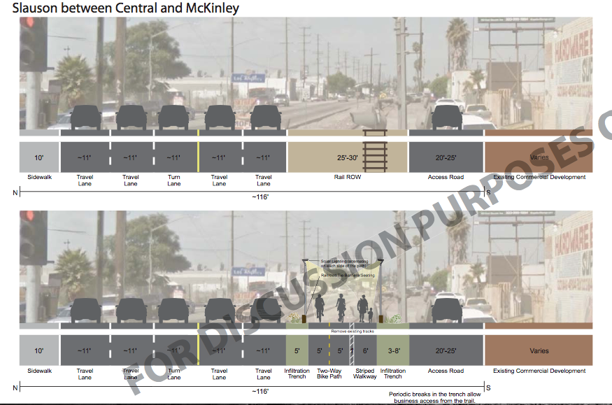
An active transportation corridor is obviously very important, especially along a busy street which is otherwise so overwhelmingly bike- and pedestrian-unfriendly. But for the path to feel welcoming and safe and get maximum usage, the more the design process can encourage local ownership the better. Partnering with local schools and artists, working with the vendors that have been there for years, engaging the health clinics about how the path can be used to improve patients’ health, and speaking with local residents about what kind of space feels welcoming to them will make for a stronger project in the end.
___
*The decision to turn the Harbor Subdivision corridor into a (temporary) bike and pedestrian path that preserves the ROW in the event it should become feasible to construct rail there at some future date has been angrily debated in each of the comments sections of previous articles on this project. Should you feel the need to once again vent your anger over the decision to stop holding the community hostage to blight while waiting for rail to become more feasible, I suggest you channel said anger more productively by contacting Metro directly. Thank you.

Read More:
Streetsblog has migrated to a new comment system. New commenters can register directly in the comments section of any article. Returning commenters: your previous comments and display name have been preserved, but you'll need to reclaim your account by clicking "Forgot your password?" on the sign-in form, entering your email, and following the verification link to set a new password — this is required because passwords could not be carried over during the migration. For questions, contact tips@streetsblog.org.