New CA Database Shows How Much Parking Costs and How Little It’s Used
Zoning laws in California usually require new developments to come with a minimum number of parking spaces. Housing, restaurants, stores, movie theaters — everything requires some number of parking spaces, theoretically based on the best available data.
Usually that data is whatever is listed in the Institute of Transportation Engineer’s (ITE) Parking Generation Manual. Since that manual has long been the only source of data on parking usage in the country, planners rely on it to help them figure out how many parking spaces a project should include.
But there are serious limitations with the ITE data, as is noted in the manual itself. As Professor Donald Shoup, UCLA’s “parking guru,” explained in a paper [PDF]: Providing too much parking encourages driving, thus contributing to congestion, and discourages walking and bicycling (unless you love walking across hot expanses of pavement to your store).
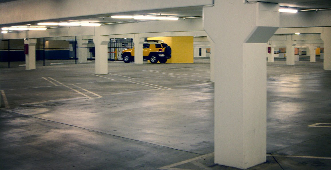
Plus, building parking is expensive.
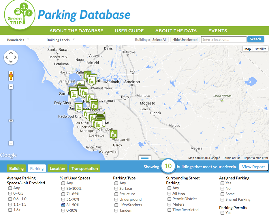
A new tool, the GreenTRIP Parking Database, can help by providing better data on actual parking usage at multifamily housing units. This is only one of the many land use categories about which planners seek data, but it is a key one.
The database, created by TransForm, an Oakland-based advocacy group that focuses on better land use and transportation policies, tracks more than just parking usage. Data is available about the number of parking spaces per unit, how much of that parking sits empty, what percentage of the building is affordable housing, whether residents pay for parking separately from their rent, what level of transit service is available nearby, whether residents are offered transit passes or carshare membership, what if any parking management exists on surrounding streets, and other data relevant to parking usage.
Released for public use a few weeks ago, the database allows users to search for and arrange information according to a long list of criteria of their choosing.
“We’ve just put out the data without prescribing what people should do with it,” said Jennifer West, a policy analyst with TransForm. “It’s a good snapshot of what’s really happening with parking usage; it will be useful to anyone who’s building or developing a project, and certainly for developers and lenders who are looking for comparisons.”
The construction cost of the unused parking appears at the top of each report, which can be generated for any set of criteria. For surface spaces, the cost for each one is around $20,000; garages and structures cost $50,000 per space; underground spaces can cost $80,000 per space. The amounts are based on work done by Todd Litman of the Victoria Transport Policy Institute.
Across all 68 sites currently in the database, on average 31 percent of the spaces go unused. That’s 867,900 square feet of space that cost an estimated $139 million to build.
No wonder parking is a major contributor to the costs of building affordable housing, as identified in a new report [PDF] from four state agencies, including the Department of Housing and Community Development and the Housing Finance Agency.
The 68 units currently in the database are located in the San Francisco Bay Area, in a variety of location types from city centers to suburban neighborhoods. The sites were chosen after considering a set of criteria (geographical distribution, representative place types as defined by the Metropolitan Transportation Commission) as well as convenience (six partner cities were eager to share information).
“Our only limit is how much money we can spend collecting data,” said West. “We’re very interested in crowd-sourcing more data. When the final version is released in early 2015, about fifteen more sites will be added.”
The level of detail available should make it useful as a planning resource throughout California, giving users the ability to compare surrounding areas and make informed conclusions about how much parking is really needed at these facility types. Its single slice of data on multifamily housing is more robust than the ITE Parking Generation Manual. The data also show a much lower rate of parking usage than the ITE manual does for similar categories.
A concern that often arises with residential developments is that residents will park on surrounding streets rather than using onsite parking. The database includes information about whether local parking is managed by metering or residential permit or some other restriction, but West said counting on-street parking spaces and vacancy rates would be too expensive and time consuming for the resources TransForm had available. “We didn’t have the opportunity to really get a handle on where residents park,” said West. “And unless we did a residential survey we wouldn’t be able to get at vehicle ownership rates. Of course, we’d like to do that kind of data collection.”
West said the data collection did reveal a few surprises. “For example,” she said, “many of the sites require valid registration and insurance to be able to park there. We don’t know how that affects onsite parking by residents.”
The GreenTRIP database will inform another TransForm project, a predictive tool called GreenTRIP Connect. The entire GreenTRIP project aims to use real-world data to clarify the greenhouse gas reduction potential of various strategies. GreenTRIP Connect will quantify the benefits of providing transit passes (which are cheaper than building parking, even for multi-member families over the course of many years), separating the cost of parking from the cost of rent, offering car-share and bike-share memberships, and including affordable housing in projects.
Meanwhile, the Bay Area’s Metropolitan Transportation Commission is launching a complementary and very ambitious project that will attempt to count on-street and off-street parking supply and usage regionally. A similar study is currently underway in San Francisco, which has already counted its on-street parking spaces. Although the scale of the MTC’s Parking Pricing Regional Analysis is very different from the GreenTRIP database — it will be studying half-mile areas throughout the region — all of these efforts recognize the importance of actual data about parking, rather than relying on guides largely based on anecdotes and incomplete studies.
Although TransForm has not released an analysis of the data, here are a few highlights at first glance:
- Only two of the 68 buildings surveyed used all their parking, based on the late-night mid-week parking counts.
- Ten of them use less than half of their spaces, including buildings in San Francisco, Oakland, Union City, Morgan Hill, and Martinez — urban, suburban, and exurban cities. One, in Berkeley, probably has a high student population, so it’s possible that counts at that building, done in the summer, don’t reflect actual parking usage.
- For the other nine buildings with half or more of their parking spaces left empty, the number of spaces per unit ranges from one space for every four units to two and a half spaces per unit. These particular buildings had transit access scores ranging from low (Morgan Hill) to high (San Francisco). Some offer a suite of alternative transportation strategies, like transit passes and carshare; some offer only the one that was available at all of them, including the senior centers: parking for bicycles.
TransForm is looking for feedback on how to improve the GreenTRIP database.

Read More:
Streetsblog has migrated to a new comment system. New commenters can register directly in the comments section of any article. Returning commenters: your previous comments and display name have been preserved, but you'll need to reclaim your account by clicking "Forgot your password?" on the sign-in form, entering your email, and following the verification link to set a new password — this is required because passwords could not be carried over during the migration. For questions, contact tips@streetsblog.org.