Alhambra City Council Approves New Bike and Walk Plan
Alhambra’s Bike and Pedestrian Plan – named Walk, Bike, Move Alhambra! – has finally passed a City Council vote after two months of delays to incorporate more community input. It was approved on Monday with four ayes, zero noes, and one abstention from Councilmember Katherine Lee.
The impetus for the plan came from sustained public pressure to make Alhambra’s streets safer (see rankings by the California Office of Transportation Safety from 2017 and 2018).
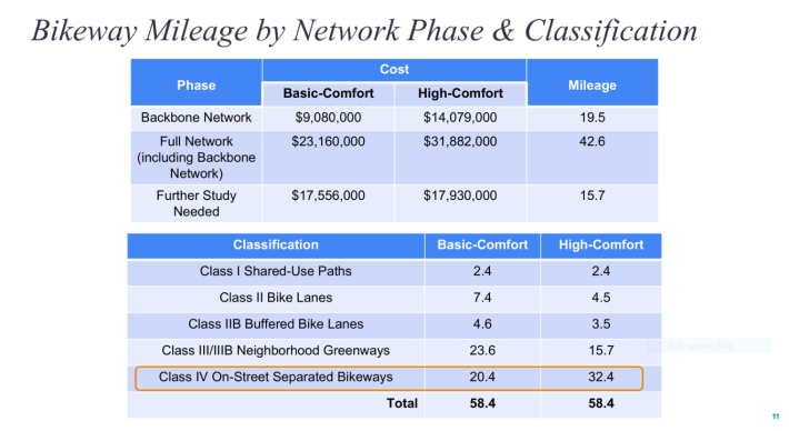
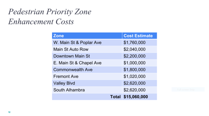
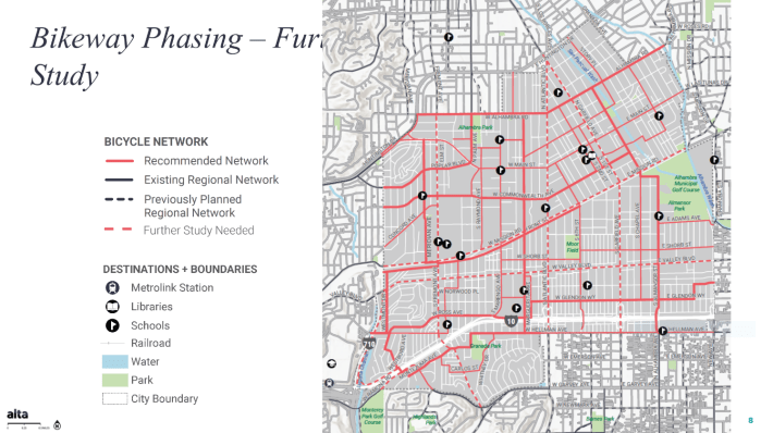
The plan calls not only for 58 miles of bike facilities, but also the development of eight “Pedestrian Priority Zones” with a mix of high visibility crosswalks, flashing beacons, leading pedestrian intervals, curb extensions, protective landscaping, and traffic circles.
Implementation of the plan isn’t funded yet. However, now that it’s been adopted, the city will petition Metro for a reallocation of $14.4 million – from the abandoned project to widen Fremont Avenue from Mission Road to Valley Boulevard – to be used as leverage in grant applications for matching funds.
On March 11, when the plan was presented again for the council’s consideration, it contained a few notable changes. The most positive one is on Commonwealth Avenue.
Ryan Johnson, a planning associate for Alta Planning + Design, told the council, “At the request of the Transportation Commission, they asked that Commonwealth actually be upgraded to have more designated bikeway facilities and not just class 3B neighborhood Greenway elements [sharrows and traffic calming infrastructure].”
“There’s one portion near the big box stores on the west side of Commonwealth where we are proposing to possibly widen the sidewalk to provide a fully separated bikeway facility through that portion where the traffic is heaviest, because changing the traffic patterns there would be more detrimental, I think to the network.” said Johnson.
Hellman Avenue was also mentioned as a street to install more striped bike lanes on as opposed to sharrows.
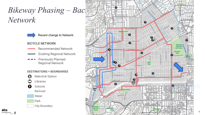
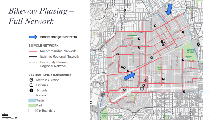
Otherwise, the current iteration of the plan adds some additional facilities to the 17 mile “Backbone Network” (prioritized for funding, easier to implement) like a neighborhood greenway on Meridian Avenue and a bike lane on Westmont Drive. In the additional 20+ miles of the “Full Network” (dependent on later funding) a mix of facilities are included on Marengo Avenue and a neighborhood greenway on Story Place.
Johnson also remarked that some shorter “stub” segments without significant connectivity were removed.
According to Assistant City Manager Lucy Garcia, these changes were based on 220+ comments focused on “improved safety near schools, lowering speed limits, bike parking, concerns over increased maintenance costs, loss of on-street parking, concern that the scope of the plan may be too large for Alhambra, more emphasis on traffic enforcement, and the importance of the plan for moving away from car dependency.”
Differing Opinions
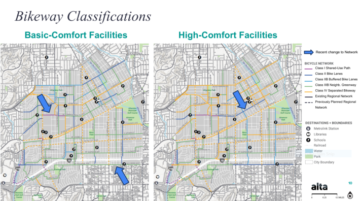
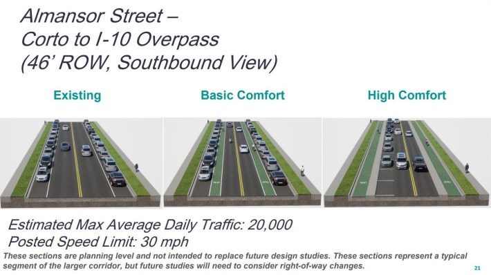
Though the plan wasn’t disparaged by members of the public or the council, there was something of a split in opinion on how far to implement the plan. This more or less broke down along the line of the less protected “Basic-Comfort Facilities” versus the more protected “High-Comfort Facilities” proposals.
The first public comment came from Elliot Lee. Lee cited the council’s commitment to its Vision Zero Plan to eliminate traffic fatalities for pedestrians and cyclists, and called on them to hold to this commitment as the Bike/Ped plan moves forward.
“During the implementation phase, the city will have countless opportunities to choose between competing interests, not all of which prioritize safety.” said Lee. “It could decide that allowing right on red in downtown and saving drivers five seconds is worth a few serious pedestrian injuries and close calls. It could decide that cyclists should be happy to get a painted lane in the car door zone and that a few cyclist fatalities are a worthy trade off for reducing driver inconvenience. It could also decide that implementing traffic calming measures near schools isn’t worth avoiding a few tragedies on the evening news. Voting to approve the plan tonight is the easy part. I look forward to working with the council in the future to make sure that the plan is fully realized and lives are saved even if it requires politically difficult decisions.”
When it came to Main Street though, home of Alhambra’s busy downtown district, Jennifer Ng had a somewhat opposite point of view.
“We have so many businesses [which] are already short on parking. Also one of the proposals was to move Main to just have one lane of traffic in each direction.” Ng began. “I understand Main’s a busy street. But we’re also the gateway to the San Gabriel Valley […] It’s a very busy street.”
From there Ng made the kinds of assertions that critics commonly apply to bicycling but would seem preposterous if applied to driving, “We also have the bike lane on Commonwealth and the bike lane on Alhambra Road, which are not very far north and south from Main Street at all [about a quarter mile to either from Main].” Ng continued. “I don’t know that we necessarily need the bike lanes on Main Street, I think there’s negatives that go along with that. And maybe we should look at that a little closer. It’s not one of the main backbone paths. So I know we have some time to look at that.”
Others spoke in favor of the High-Comfort map, and others spoke in favor of parking spaces around popular destinations like Alhambra and Almansor Parks, though Johnson reminded everyone that there is still much more studying and outreach to be done before implementing any specific projects.
Larger corridors, like Valley Boulevard, Garfield Avenue, Mission Road, Fremont Avenue, and Atlantic Boulevard are still marked for “Further Study” and have no particular facilities prescribed.
Further study is what Councilmember Katherine Lee would like to see on Main Street.
“I still don’t understand why Main Street’s being excluded from the Further Study category,” said Lee, “because it is a corridor […] with two hospitals on each end of Main Street, and I am concerned about that.”
Overall, Councilmember Lee seemed to have reservations about fully endorsing a plan that, while nascent and general now, could later become unpopular with some voters.
“Right now, I can easily say yes, and look great. But I will have to communicate with the residents. And [if they say] ‘Well, you took my parking spaces,’ then I don’t look great after that.” mulled Lee.
Then she made her perspective clear.
“I’d like to motion to remove all High-Comfort level plans from the plan right now – tentatively – a motion that I don’t know anyone will second, because I am not very comfortable with what the negative impact of the high comfort level of the bike plan is right now. There’s too many things that are going to be impacted. Parking spaces will be taken away, only one traffic lane on each side, that’s possible. I’d like us to think about something else. I think the basic level is fine. That is a shared path.” Lee said.
But as she surmised, no other councilmember seconded her motion, which came after a previous motion by Adele Andrade-Stadler to adopt the plan.
As council comments moved on, Jeffrey K. Maloney – who is part of the subcommittee that oversaw the plan’s development – spoke in defense of the High-Comfort Facilities.
“There are some areas – we saw the overview of the western part of Main Street – and one side has four lanes of traffic.” said an impassioned Maloney. “It’s completely unnecessary, we can easily remove one of those lanes of traffic or more. We have to look for the opportunities to make sure that people feel comfortable when they get on their bike, that they’re not going to get sideswiped by a car, they’re not going to get ‘doored’ when they’re in the bike lane.”
“I don’t think we’re going to be able to do high comfort on every single red line on this map,” Maloney went on, “but we should do it as much as we can, or this thing isn’t worth the paper that it’s written on.”
Shortly after, the council voted and approved the Bike and Pedestrian Plan.
Streetsblog’s San Gabriel Valley coverage is supported by Foothill Transit, offering car-free travel throughout the San Gabriel Valley with connections to the Gold Line Stations across the Foothills and Commuter Express lines traveling into the heart of downtown L.A. To plan your trip, visit Foothill Transit. “Foothill Transit. Going Good Places.”Sign-up for our SGV Connect Newsletter, coming to your inbox on Fridays!

Read More:
Streetsblog has migrated to a new comment system. New commenters can register directly in the comments section of any article. Returning commenters: your previous comments and display name have been preserved, but you'll need to reclaim your account by clicking "Forgot your password?" on the sign-in form, entering your email, and following the verification link to set a new password — this is required because passwords could not be carried over during the migration. For questions, contact tips@streetsblog.org.