
Metro and Caltrans 605/60 Freeway Widening Project Could Demolish San Gabriel Valley Homes
Metro and Caltrans plans for freeway widening could demolish more than a dozen homes in the heart of the San Gabriel Valley. While plans have not been finalized, early designs for Metro and Caltrans 605 Freeway Corridor Improvement Project (605CIP) show several demolitions in South El Monte and Pellissier Village. In addition to razing homes, the 605CIP would worsen air pollution, noise, traffic congestion, and greenhouse gas emissions.
Note that Metro and Caltrans’ 605 Freeway expansion designs are in flux. There are no final totals of homes impacted, nor final maps showing parcels that agencies would acquire.
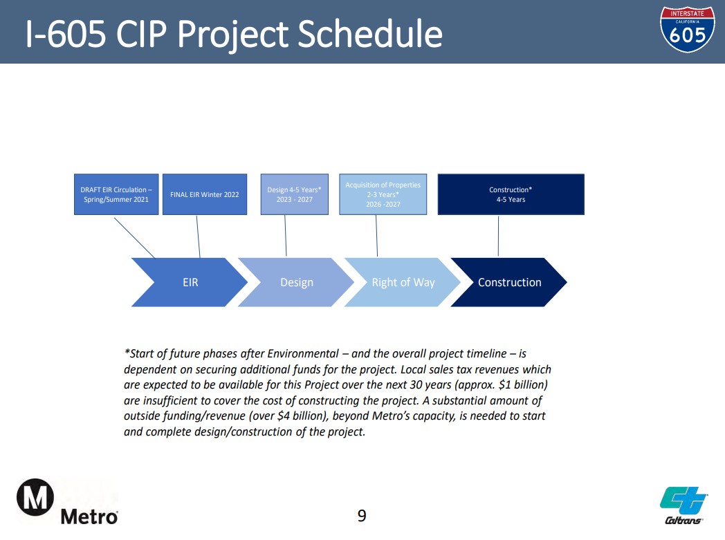
Metro and Caltrans completed initial designs for much of the 605CIP nearly a decade ago; these include Project Study Report-Project Development Support documents (PSR-PDS) for the south 605/5/105 area in 2014, then for the north 605/60 area in 2015. By 2020, Metro had “drastically” expanded those plans, increasing the freeway widening footprint, meaning increased demolitions of homes, businesses, etc. compared to the 2014-2015 designs. Since late 2020, Metro has been working on revised designs that the agency asserts would reduce impacts to adjacent parcels, but those designs have not been made available to the public.
This post reviews earlier plans, extrapolating what might be expected as Metro looks to share some new 605CIP information in community meetings in the next couple months. Project approval could follow in a year or so; the soonest any property acquisition might get underway would be around 2026 (per Metro).
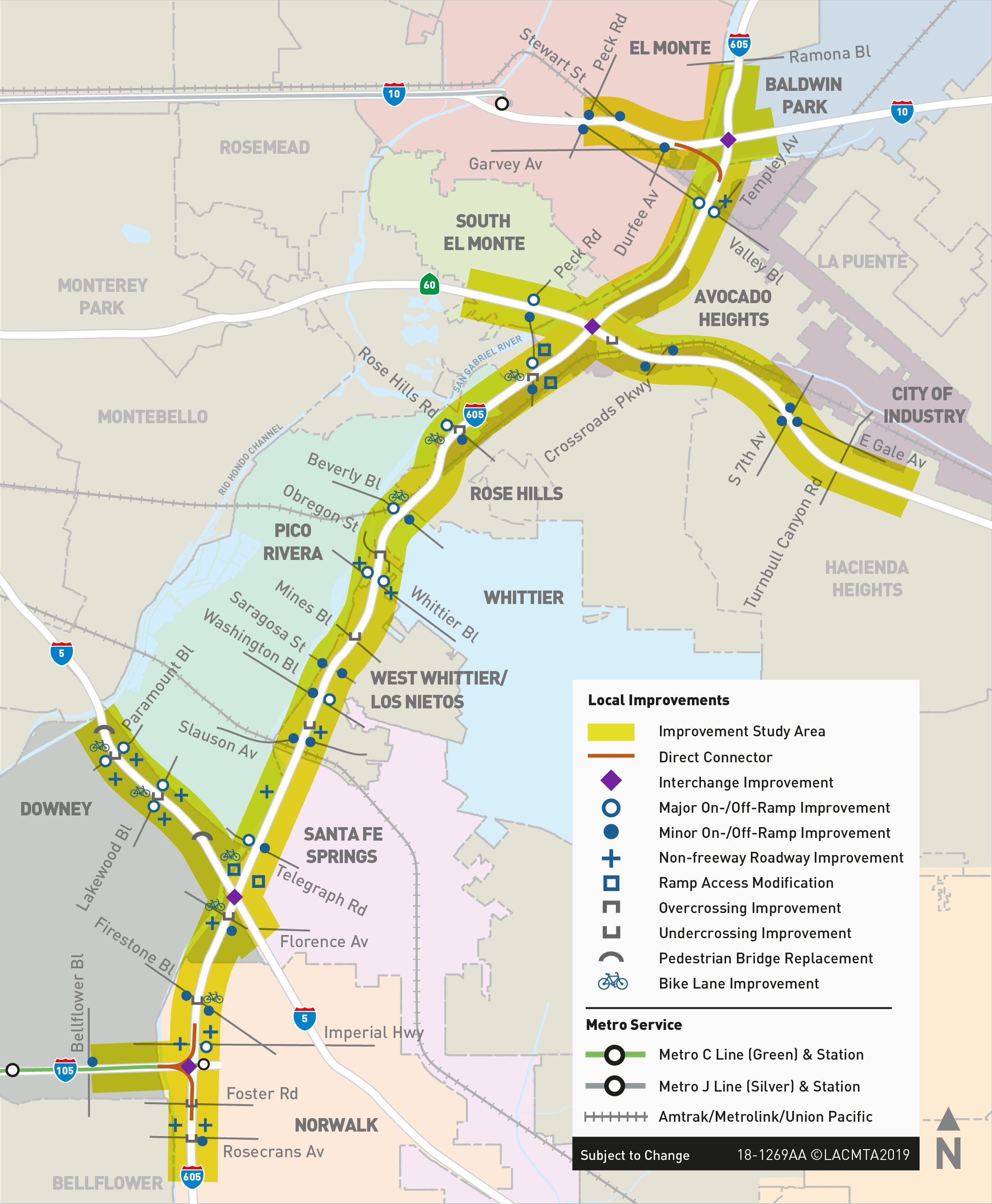
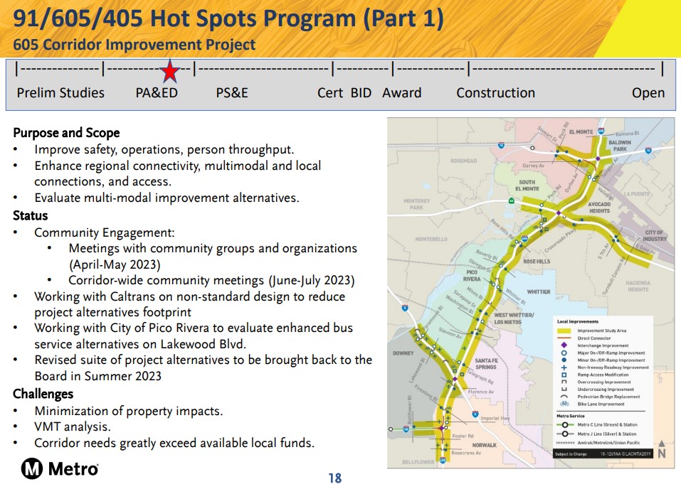
The proposed $5+ billion 605CIP would widen about 12 miles of the 605 Freeway in the San Gabriel Valley and Gateway Cities, with additional freeway widening on parts of four connecting freeways: the 10, 60, 5, and 105.
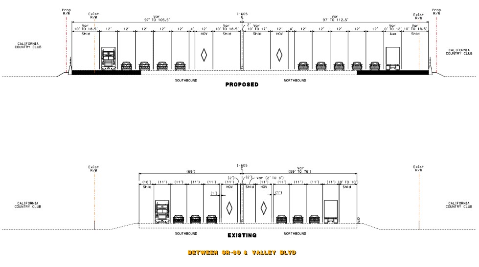
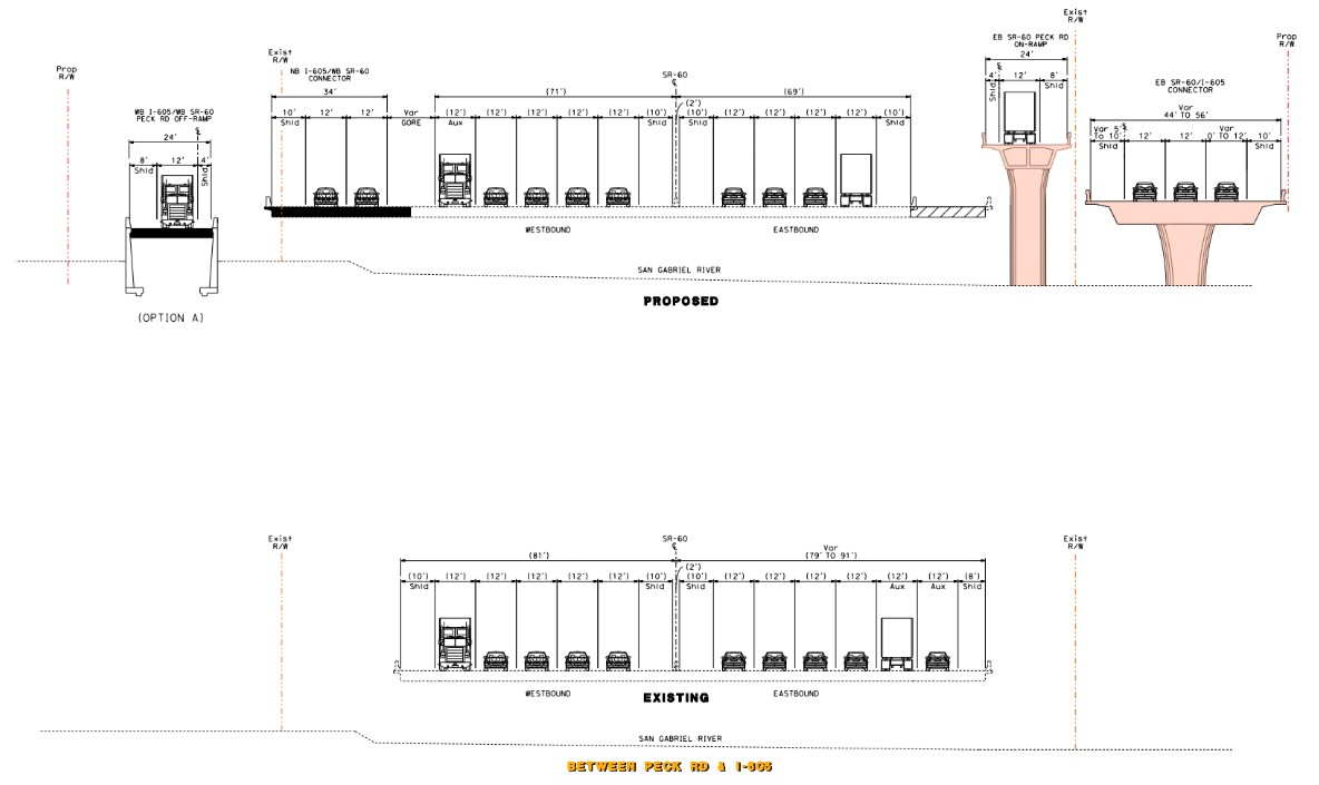
Most of the 605 Freeway expansion would not displace homes or other buildings, as it would primarily take place in what is today landscaped margins along the freeway. The project would include quite a few impacts to adjacent properties: at 605 Freeway on-/off-ramps, at freeway interchanges, and along connecting freeways – mainly along the 5 and the 60.
When Metro last presented detailed information on its 605CIP project, in August 2020, Streetsblog focused on the hundreds of home demolitions planned along the 5 Freeway. At that time Metro announced that 300+ parcels – mostly homes and apartment buildings – in Downey and Santa Fe Springs would be acquired to widen the 5. In October 2020, the Metro board approved a motion that paused the 605CIP approval process, directing staff to develop designs that would minimize property impacts, and to do outreach to project stakeholders.
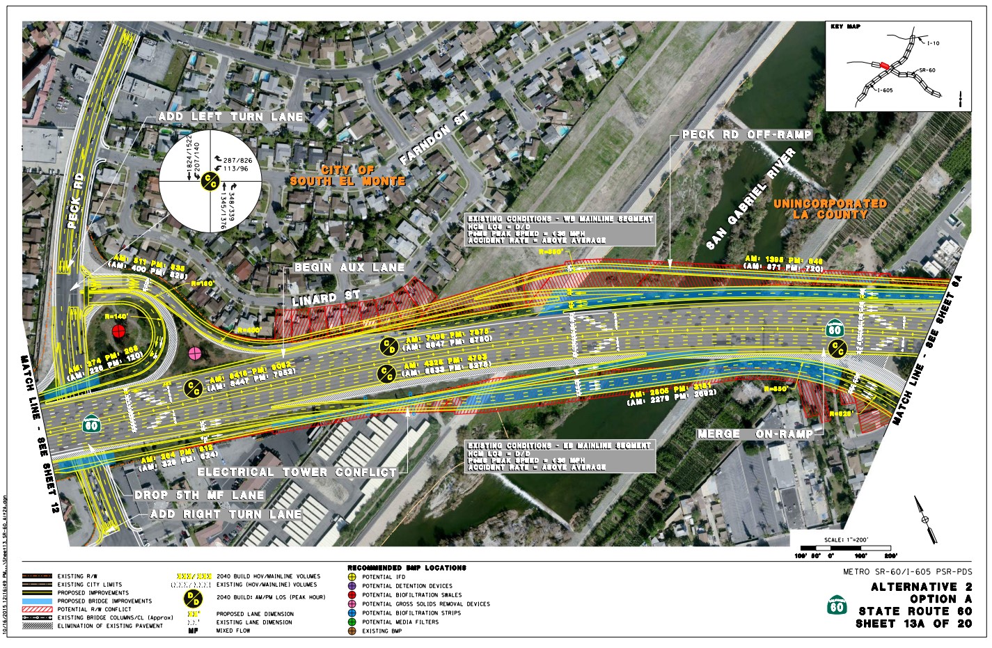
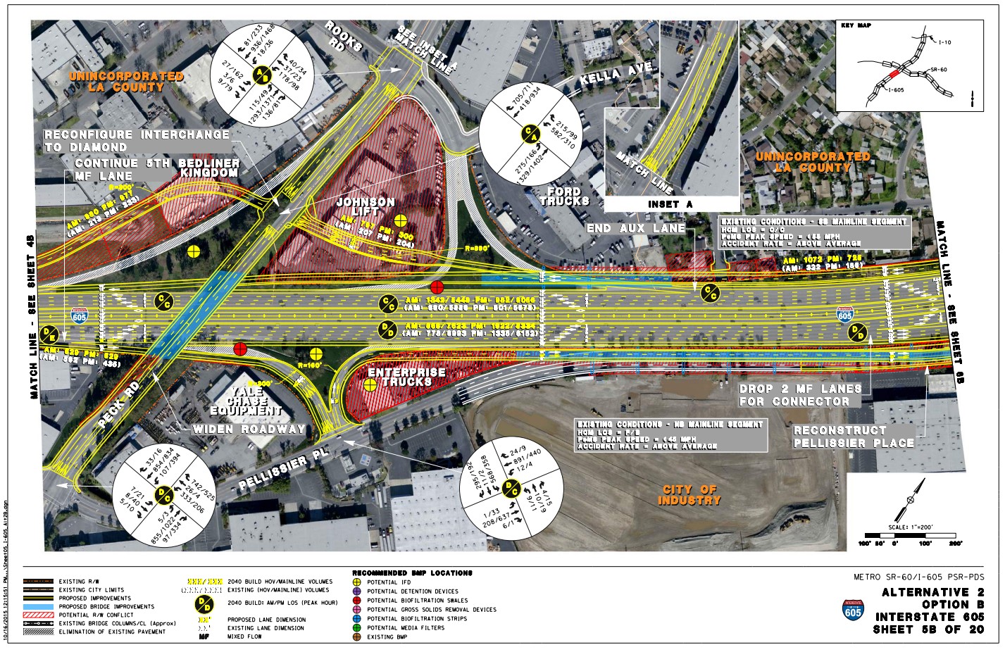
In addition to those demolitions at the south end of the 605CIP, the Metro/Caltrans 2015 PSR-PDS shows proposed demolitions toward the north end of the project. The north part of the 605CIP would widen the 605 Freeway from Beverly Boulevard (in Pico Rivera and Whittier) to the 10 Freeway interchange (in Baldwin Park), and also widen the 60 Freeway from Santa Anita Avenue (in South El Monte) to just east of Turnbull Canyon Road (in Hacienda Heights).
According to maps in the 2015 designs [PSR-PDS appendices page 22], the 605CIP would demolish:
- 7-9 homes in the city of South El Monte, on the south side of Linard Street, just north of the 60 Freeway
- Two homes (and a horse stable site) on Famosa Street in the Pellissier Village neighborhood located just southwest of the 605/60 interchange (technically part of the unincorporated L.A. County community of Avocado Heights)
The PSR-PDS designs include a handful of alternatives and options, some with larger and smaller project footprints, though all the different 2015 alternatives show home demolitions on Linard and Famosa. See below for additional homes and other sites threatened only by more expansive alternatives.
Back in 2015, for just the north part of the 605CIP, Metro and Caltrans’s affected property totals show 11-29 residential full demolitions, plus another 2-12 commercial/industrial full demolitions, totaling 13-41 full acquisitions.
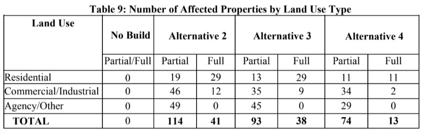
Then, between 2015 and 2020, Metro expanded the number of planned demolitions. Though Metro didn’t publish apples-to-apples data, SBLA calculates [see spreadsheet] that, for the north end of the 605CIP, the total full acquisitions went from 13-41 to ~44-45.
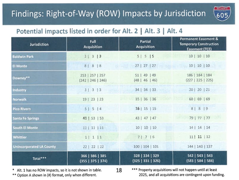
In 2020, Metro only shared the total numbers of right-of-way impacts by jurisdiction, and has not made further information (no map, addresses, nor whether properties are residential or other) available that corresponds to these totals.
For the city of South El Monte, Metro’s 2020 demolition numbers show 11 full acquisitions, which are likely the 7-9 Linard parcels, plus some unidentified others.
For unincorporated L.A. County, Metro had announced 22 full acquisitions. A few of these are on Famosa, but it is not clear where the others are. Some may be along the 605 in Avocado Heights, south of Valley Boulevard (see below); some may be in the southern end of the 605CIP (in unincorporated West Whittier/Los Nietos).
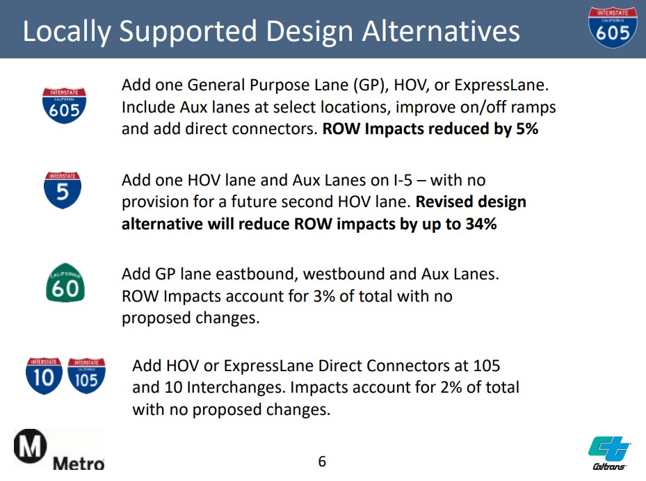
In early 2021, as the agencies began developing less harmful 605CIP alternatives, Metro presented some concepts for reducing the project’s right-of-way impacts. At that time, there were “no proposed changes” to impacts along the 60 Freeway (where Linard and Famosa homes are) as parcels impacted there only accounted for three percent of overall acquisitions.
Last month, Streetsblog asked Metro and Caltrans if the Linard and Famosa properties were still under threat of demolition. Metro Media Relations Manager Patrick Chandler responded without answering the question, noting that the 605CIP “is still in the pre-environmental review stage” and “Metro’s Highway Programs staff expect to update the Metro Board in late summer or fall of this year and will provide an update on the schedule and milestones for the project at that time.”
Caltrans District 7 Media Relations Manager Eric Menjivar responded, “We have nothing to add at this time” deferring to Metro’s response.
So what do the threatened places look like?
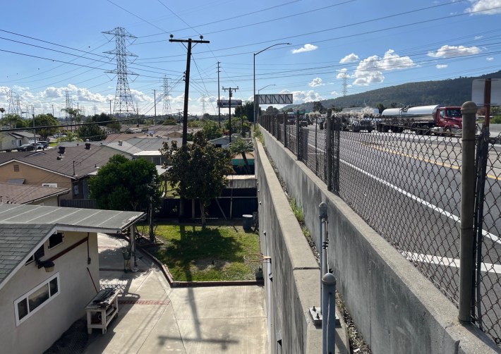
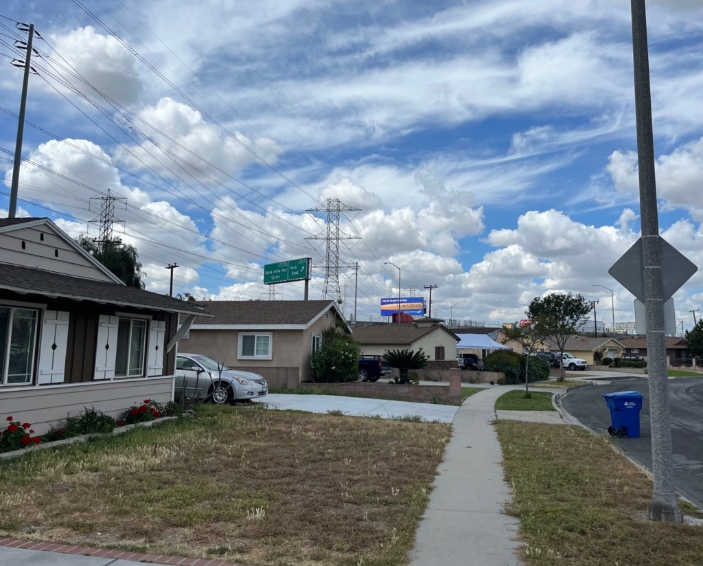
South El Monte is a working class, predominantly Latino city. Many of Linard Street’s 50s era single-story homes’ backyards directly abut the retaining wall along the 60 Freeway and the Peck Road off-ramp.
Widening the 60 there, by more than a few feet on the north side, will conflict with yards, then homes.
ActiveSGV Executive Director David Diaz responded to Metro and Caltrans proposed South El Monte home demolitions noting “It’s like they’ve learned nothing from the historical record of freeway expansion and how it negatively impacted Black and brown folks — trauma of displacement, loss of generational wealth, and destroying a lifetime of memories!”
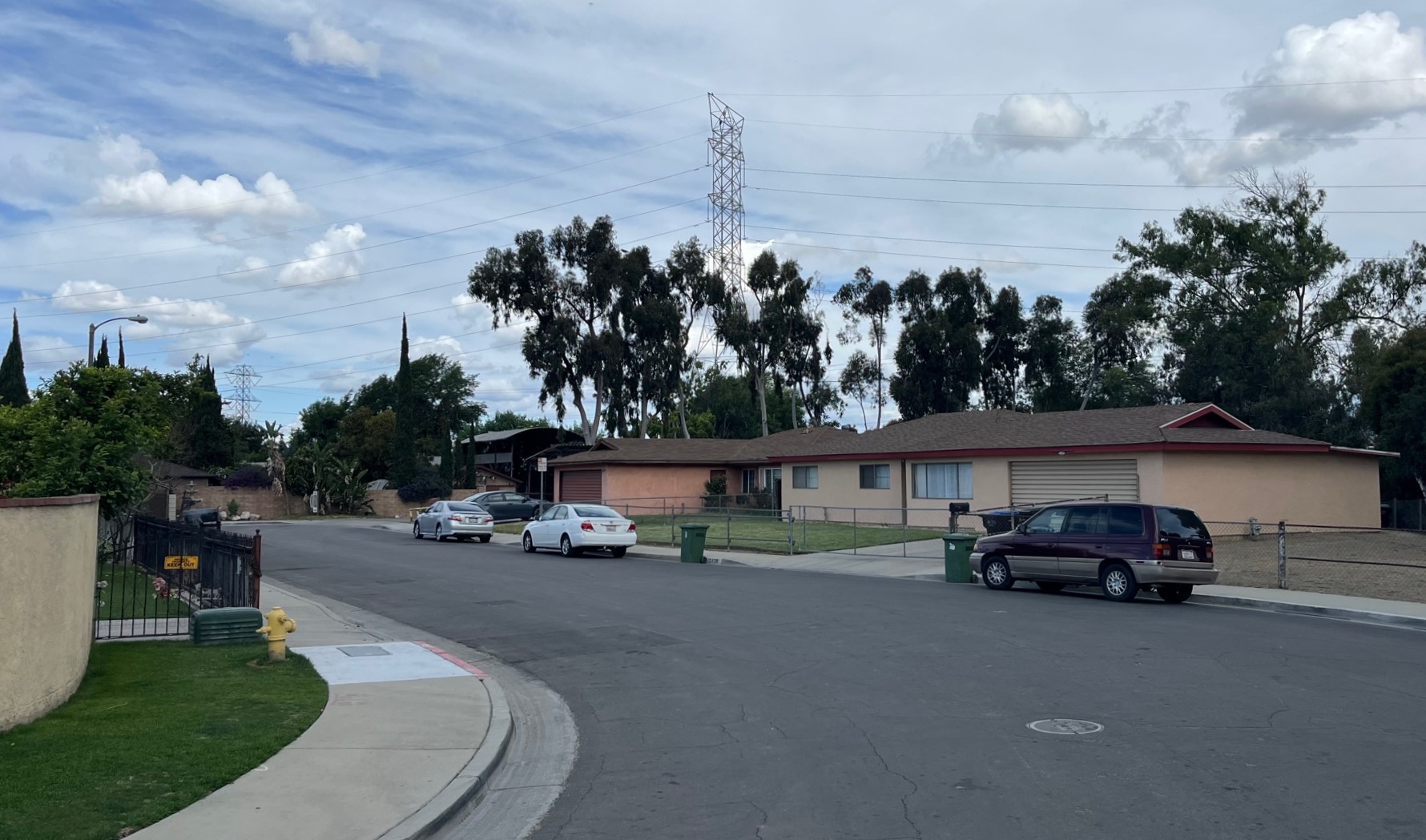
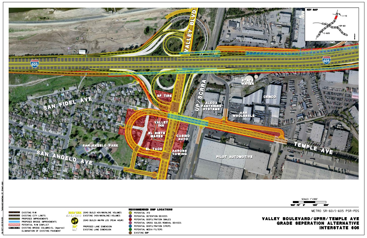
Tucked behind industrial development, and in the shadow of the 605/60 Freeways interchange, is a small residential and equestrian community called Pellissier Village. The 2015 freeway widening maps show a couple of demolitions – two homes and a horse stable – near the dead-end of Famosa Street.
Three additional Pellissier Village homes – at the south end of Kathleen Street – are also shown as possible demolitions in Metro and Caltrans’ larger-footprint 2015 alternatives (“option B”).
In the northern end of Avocado Heights, there are about 16 homes and a couple of retail establishments (including the Valley Inn motel) threatened under some Metro/Caltrans alternatives. Those homes are located just south of Valley Boulevard on Arillo Street, Ramada Avenue, San Fidel Avenue.
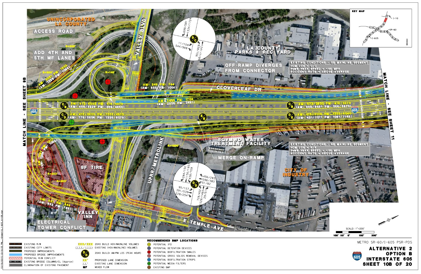
One further Temple Avenue Grade Separation alternative would remove additional businesses and homes along and south of Valley Boulevard, including cutting off a corner of San Angelo Park.
“The widening of the 605 Freeway along Valley Boulevard has worrying implications for a community that is already struggling from a high pollution burden and adverse exposure to cumulative environmental impacts,” notes Samuel Brown-Vazquez of the Avocado Heights Vaquerxs. On the Temple grade separation alternative, Brown-Vazquez stated that “this widening represents the loss of thirteen homes in our community (five near a park), the loss of a hotel for low income guests, and the permanent removal of a beloved mariscos joint. We are outraged by this proposal.”
At various points along the 605 and 60 freeways, in addition to homes proposed to be demolished, Metro and Caltrans plans show numerous impacts to industrial sites. More than a dozen industrial parcels are shown as right-of-way conflicts (full acquisitions); numerous other businesses would lose slivers of their properties.
What happens next?
Metro and Caltrans are proceeding with three relatively small scale ramp and street widenings (termed 605 Freeway “Hot Spots”) that set the stage for later major 605CIP widening. These early action projects include:
- widening Valley Boulevard and its 605 Freeway on-/off-ramps in the city of Industry and Avocado Heights
- widening road and ramps at the 605 and Beverly Boulevard in Whittier
- widening 60 Freeway 7th Avenue on-/off-ramps in Hacienda Heights (currently on hold)
For the larger overall 605CIP, Metro is restarting its community engagement process. The most recent rounds of Metro/Caltrans community meetings on the project were in 2016 and 2018.
In a project update last month, Metro announced that its project team is currently meeting with community groups, and is planning corridor-wide community meetings this June and July. Stay tuned to SBLA for details when the meeting dates have been announced, or check Metro’s 605CIP webpage, which includes project email and phone contact information.
Streetsblog recently discussed Metro and Caltrans 605CIP plans and possible displacements with Coalition for Clean Air Executive Director Joe Lyou, who also serves on the California Transportation Commission. “Induced traffic demand is a real thing,” Lyou noted that agencies “aren’t going to solve congestion by widening, but should take a better-informed approach.”
Lyou expects that equity commitments from Caltrans, CTC, and the CA State Transportation Agency (CalSTA) should prevent or minimize new freeway project displacements in low-income communities of color.
Lyou also points to Metro and Caltrans’ lower 710 Freeway example, where these agencies pivoted from freeway widening plans to considering multimodal corridor investments. For the 605, 60, and 5 Freeway projects under development, Lyou stated “air quality, community and equity concerns are the same as the 710.” He said, “It’s the same air basin as the 710” with the “same Clean Air Act attainment requirements,” meaning that Metro should have to meet Clean Air Act limits on new freeway expansion that would increase polluting truck trips.
The Happy City Coalition, which was co-founded by Alex Contreras in response to planned Metro demolitions along the 5 Freeway in Downey, responded to Metro’s ongoing push for the 605CIP, in a statement noting that “Transit agencies… should not be exacerbating climate change by tearing down homes and expanding freeways, [because] freeway expansions only cause harm and it is crucial that our transit agencies begin redirecting time, money, and energy into multimodal public transportation.”
Metro and Caltrans have been backing off of some freeway expansion where it would demolish homes.
Metro now has policies mandating that its projects support equity (adopted 2018) and multimodal objectives (adopted 2022). Caltrans has similar policies on equity (released 2020) and climate (released 2021).
In 2020 Metro released a statement that noted that “Freeways… built through minority communities” are “what has come before” and not part of Metro’s “building a better future.” Soon after, Metro canceled its plan to demolish hundreds of homes/apartments/businesses to widen the lower 710 Freeway. Metro also scaled back 91 Freeway expansion plans that had been approved to demolish a half dozen homes and a business in the city of Artesia. In 2022, Metro announced that its current highway program budget funded “highway projects… on SR-91 and I-605, all done within existing freeway corridors — meaning there is no need for relocations.”
The overall 605CIP designs will be a test of the agencies’ stated commitments to shift projects toward equity and multimodal transportation.
A January 2023 Metro board box memorandum on the 605CIP offers some hints at the new alternatives that the agencies have been developing for the last two and a half years. The memo notes that Metro staff are “review[ing] the project’s purpose and need and its alignment with various state policies related to equity and climate change.” Metro is also evaluating including “local multimodal improvements (e.g., pedestrian enhancements, bike lanes, transit stop improvements)” in the 605CIP. Regarding demolitions, the memo notes that Metro has worked with Caltrans “to substantially reduce or avoid the right-of-way impacts previously anticipated for the project alternatives” and that, under revised designs not finalized at that time, “the number of potential property acquisitions/relocations that would be required for the project alternatives has been reduced significantly, or by several orders of magnitude.”
The wording in the January memo seems to point to a radically different project than what Metro and Caltrans designed in 2015 and 2020, but the devil will be in the details.
Will Metro and Caltrans engage impacted communities, and come up with a 605 corridor project that centers health, equity, clean air, and climate? Or will Metro and Caltrans do pretty much what they have nearly always done, continuing to demolish neighborhoods of color in order to add more freeway lanes? Time will tell. And the community can influence the agency’s plans by attending the meetings starting next month.
Streetsblog’s San Gabriel Valley coverage is supported by Foothill Transit, offering car-free travel throughout the San Gabriel Valley with connections to the Gold Line Stations across the Foothills and Commuter Express lines traveling into the heart of downtown L.A. To plan your trip, visit Foothill Transit. “Foothill Transit. Going Good Places.”
Sign-up for our SGV Connect Newsletter, coming to your inbox on Fridays!

Streetsblog has migrated to a new comment system. New commenters can register directly in the comments section of any article. Returning commenters: your previous comments and display name have been preserved, but you'll need to reclaim your account by clicking "Forgot your password?" on the sign-in form, entering your email, and following the verification link to set a new password — this is required because passwords could not be carried over during the migration. For questions, contact tips@streetsblog.org.