For the most part, Glendale has received infrequent but positive coverage on Streetsblog Los Angeles. Following the "embedded activist" experiment with the Los Angeles county Bike Coalition and Colin Bogart as part of a County Department of Public Health grant proved a successful model for cities looking to embrace livability and the past couple of years have produced a slow stream of bicycle and pedestrian improvement projects. And, of course, there was was that awesome traffic sting they did with the Easter Bunny.
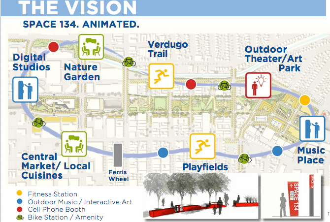
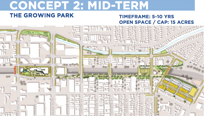
But nothing they've worked on is quite like this. Tonight, the City Council will hear the "Space 134" proposal to "cap" State Route 134 between Central Avenue and Glendale Avenue and place a park on top of it. The proposal calls for a 5 acre park built in the next five years, a 15 acre park five years after that and a 28 acre park in two decades. The park is designed to connect the local community to the city's cultural and economic core through a series of bicycle and pedestrian trails.
I mean, the Riverdale-Maple Greenway is cool and all...but it's not a Cap Park.
Cap parks are becoming an increasingly popular way to re-create open space in areas lacking this basic feature. In many cases, freeway planning has divided communities and gutted the ability of less-affluent areas to afford park land.
As part of the PLACE grant, Glendale conducted a "2009 City of Glendale Quality of Life Indicators." The study showed that the distribution of developed parkland in Glendale were found in the eastern and northern sections ofthe city. There there is between 3.35 and 6.67 acres of parkland per 1,000 residents.
In the southern section of Glendale, where Space 134 would be built, the density is 0.64 to 0.017 acres per 1,000 residents. The location of SR 134 is a major cause of this problem. Capping it and creating open space could be a part of the solution.
The Space 134 study proposes am ulti-modal transit stop on the East-West corridor between the North Hollywood Red Line Station and the Pasadena Del Mar Gold Line Station. Metro identifies this area as a potential corridor for bus-rapid transit or even light rail. As it will take decades to complete the Space 134 project in the best circumstances, it makes sense to plan for the existing transit of today and future transit options, argue the report authors.
In addition, Space 134 provides a link connecting the southern part of the city to the existing and growing bicycle network for proposed bicycle routes that cross the 134 freeway including Louise and Geneva Avenues.
The final vision for the proposal has a lot to offer people interested in Livable communities New local markets, places for people to gather, exercise trails, bike trails and a ferris wheel. Really, a ferris wheel. Eat your heart out Santa Monica.
But while this may seem "pie in the sky" at the moment, the five-year initial build out still has a lot to offer.
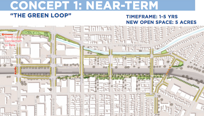
The "Green Loop" pictured above features only five acres of new open space surrounding the freeway and local streets. Pockets of open space dot the map, and connections over the 134 would allow for improved access to communities in southern Glendale. In addition, there is new open space options created, although sadly there is no ferris wheel. There is also no actual "capping" of the freeway.
As the program advances, more and more of the "Vision" comes into focus.
The near-term conceptincludes improvements to existing bridges,incorporation of public art and adding pedestrian lighting to roads and bridges.
Much of the design work was completed by Melendrez Design Partners, the same people who did much of the work on MyFigueroa! featured yesterday on Streetsblog.
The proposal was funded through a grant from the Southern California Association of Government's "Compass Blueprint Grant Program." Currently, there is no funding set aside for park construction. However, the Glendale City Council has shown vision and features two of our favorite elected officials, Laura Friedman and Ara Najarian. If the public truly gets behind this proposal, the sky can indeed be the limit. Local news blog Tropico Station is encouraging people to attend tonight's meeting and/or email the Council their support.
Because we'll be able to get there in a ferris wheel.
