Second Steps: The Riverdale-Maple Greenway Will Connect Parks In Glendale
As part of every Policies for Livable Active Communities and the Environment (PLACE) Grants awarded by L.A. County Department of Public Health in 2008, each community had to complete a sample project that demonstrated the types of street improvements that could spread throughout their city as a result of improved planning. The City of Culver City completed the Downtown Connector project that provides a Sharrowed street connection between the Downtown and the future Expo Station while linking residents to local schools. Long Beach spent their money on the Green Sharrowed Lane in Belmont Shore.
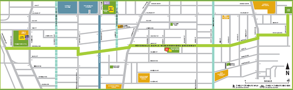
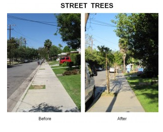
Glendale’s project is completed yet, the contractor just got approval to begin construction, but it is similar to the other two projects we’ve reviewed. The Riverdale-Maple Greenway will connect three parks in Glendale: Pacific Park and School, Maple Park and Community Center and Carr Park. When completed the Greenway will have 124 new trees along the corridor, repaired and widened sidewalks, wayfinding and promotional signage and bike lanes on Riverdale (the western portion of the Greenway) and Sharrows along the rest of the route on Maple Street, Rock Glen Avenue and Lincoln Avenue.
PLACE Coordinator Colin Bogart explains the thinking behind the project. “By making it easier to access the park and the areas around the park, you’re going to get more people in the park and more people walking and biking in the neighborhoods.”
While none of the treatments considered for the Greenway are new to Glendale, this is the first time the city is coordinating a group of different designs and additions to create a special corridor friendly to all road users. “The idea of consolidating it in one place, and to use all these funding sources to create a corridor, that was the leap,” explains Marc Stirdivant with the city’s Parks Department and one of the authors of the PLACE Grant.
From a public health standpoint, PLACE is a public health grant after all, it’s a great low-cost investment to provide bicycle and pedestrian access to parks. Not only does the project, spanning almost the entire east-west portion of the city, connect neighborhoods but it makes it easier for people to get to their local park without having to get into a car. This will actually increase the physical activity of adults more than kids, as personal experience has taught me that kids have no trouble exercising at parks, and parents can get into the action mostly by exercising on the way to and from the park.
The project is a strong example of the city’s commitment to creating a walkable and bikable transportation grid. Only $20,000 of the $320,000 from the PLACE Grant is going to cover the physical projects. The total cost of the Greenway is roughly $500,000. Also, the original proposal didn’t include the last two segments of the Greenway that connect to Carr Park in the Northeast corner of the map on Rock Glen and Lincoln. After Alta Planning and Design reviewed the city’s initial plan, they urged Glendale to consider adding the spur to include the third park, and the city embraced the additional project.
At first, it seemed the main barrier to completing the project would be the intersection of Central and Maple. The intersection was one of the most dangerous crossings, especially for pedestrians, and required Greenway users (riders and walkers) to make a pair of turns to stay on the Greenway.
“If you were a pedestrian and you wanted to cross here, you were essentially out of luck,” Bogart remarked of the road configuration.
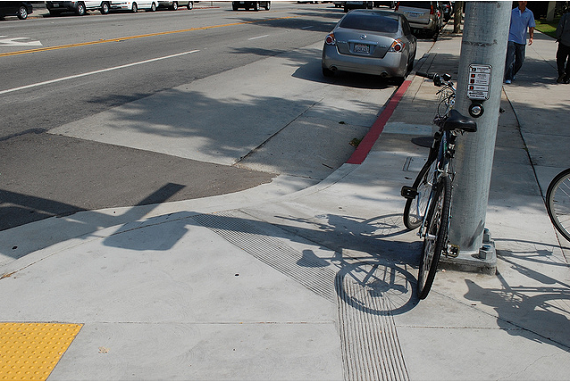
Fixing the intersection was going to be a daunting and expensive task, until city staff noted that there was an improvement project already on the books. Using federal stimulus funds, the city not only added new crossings to the street, but also a series of bump outs to both slow traffic and decrease the length of the crossing for pedestrians. In addition, the city put in bike detectors connected to the traffic signal and marked their location on the street to make bike crossings easier.
Glendale was actually a somewhat controversial selection when the PLACE grants were first announced. According to the census, the city is white (over 71%), middle class (median household income approaches $70,000) and suburban. Yet, the Greenway demonstrates not just a commitment to creating livable streets where people can walk and bike where they’re going or just be outside without being harassed by traffic, but also a commitment to equity.
The above map shows that the corridor skirts along the densest, most diverse part of the city. The blue line represents the corridor, the darker the red the more dense the area’s housing, and the darker the circle the higher the percentage of residents are minorities. Whatever one’s views of Glendale, the Greenway serves the most urban part of the city. South of the Greenway, is the civic center and jobs clusters so the residential portion isn’t as dense as north of the Greenway, but connections to jobs is an important part of a working network.
The Greenway also connects to existing infrastructure. The map at the top of this article shows existing and planned bike routes that connect to the Greenway and one intersection on Riverdale already has a traffic circle. Riverdale itself already has bike lanes, but they’re incomplete as they don’t have an “inside stripe.” Once Riverdale is repaved the lanes will be repainted and completed.
As we noted above, the project isn’t completed yet. We’ll go back to Glendale to ride the Greenway and write a full review when it’s completed.
Damien Newton wrote this story while participating in The California Endowment Health Journalism Fellowships, a program of USC’s Annenberg School for Communication & Journalism.

Read More:
Streetsblog has migrated to a new comment system. New commenters can register directly in the comments section of any article. Returning commenters: your previous comments and display name have been preserved, but you'll need to reclaim your account by clicking "Forgot your password?" on the sign-in form, entering your email, and following the verification link to set a new password — this is required because passwords could not be carried over during the migration. For questions, contact tips@streetsblog.org.