How Mayor Garcetti Can Make L.A. Bike-Friendly – 1: Easy Bike Facilities
Los Angeles Mayor Eric Garcetti – photo via mayor’s website
With Los Angeles Mayor Eric Garcetti's recent landslide re-election, City Councilmembers facing windfall 5-year terms, Measure S defeated soundly, and Measure M's super-majority passage last November, the local political landscape appears riper than ever for steps forward toward making L.A. more conducive to walking and bicycling.
Streetsblog L.A. is planning a series of articles to look at what Garcetti's second term transportation/livability agenda should look like. Future articles will focus on walkability. Today's article, the first in the series, is about facilities that Garcetti can implement in the relatively short run to make the city of L.A. better and safer for bicycling.
Garcetti's Bike Facility Record So Far
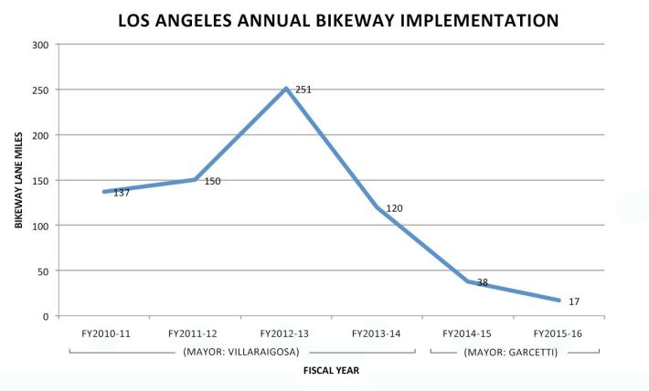
After reaching a high during the previous Villaraigosa mayoralty, LADOT bicycle facility implementation has slowed under Mayor Garcetti.
Garcetti has emphasized a fairly high-profile Great Streets Initiative, though this only applied to 15 high-profile corridors (some of which have been undermined by councilmembers), adding up to a mere token in the larger citywide streets picture.
With so little bicycle mileage implemented under the initiative, perhaps Garcetti could augment the program with a similar signature initiative focused on bicycle facilities. A "Great Bikeways Initiative" could offer 10-15 significant signature bike facilities designed to strategically improve safety and increase bicycling.
Garcetti's LADOT, under General Manager Seleta Reynolds, has often emphasized quality over quantity. Unfortunately, overall quantity has plunged during Garcetti's term. The trend is disconcerting; Fiscal Year 2015-16 was significantly worse than FY2014-15.
Quality has improved, however. LADOT had refused to do protected bike lanes prior to Reynolds' tenure. In 2015, LADOT implemented the one-mile-long Reseda Boulevard protected lanes. At the time, there was enthusiasm for converting plenty of conventional and buffered bike lanes into protected ones, but that conversion has proceeded very slowly, with only 1.3 more miles (Los Angeles Street and Van Nuys Blvd.) to date. These are great facilities, but at the current rate of less than one new mile a year, they will not add up to a significant network during Garcetti's term.
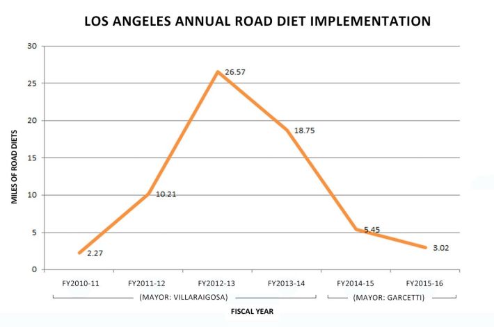
One measure of quality is implementation of road diets. Diets reduce the overall number of car travel lanes, generally replacing one car lane with two bike lanes, sometimes adding a center turn lane and/or parking. Road diets are a federally-acknowledged safety improvement that results in safer streets for drivers, pedestrians, and cyclists. During Garcetti's first term, LADOT implementation of road diets declined significantly.
Bicycle advocates have expressed their frustration with the lack of bike facility progress under Mayor Garcetti. In a stinging L.A. Times editorial, Bike the Vote's Michael MacDonald put it this way:
When it comes to actually making the tough political decisions needed to implement [city plans for bike facilities], however, our leadership has been lacking — particularly from Mayor Eric Garcetti. ... [Garcetti] will need to move beyond celebrating small pilot projects and start pushing for an extensive network of family-friendly protected bike lanes, while ensuring that LADOT is adequately funded and staffed to get the job done.
Compiling a Facilities Agenda for Making L.A. Bicycle-Friendly
Shortly after the March 5 election, Streetsblog L.A. asked various cyclists and cycling organizations to offer input on what they would like to see Garcetti do to make L.A. more bike-friendly. Among the folks reached out to were Bike the Vote, Multicultural Communities for Mobility, the L.A. County Bicycle Coalition, the Bicycle Kitchen, BikeRoWave, and C.I.C.L.E. - as well as several individual cyclists, some of whom are bike facility planners. SBLA also culled from various city plans including the most recent LADOT bike project list, the 2010 Bike Plan, that plan's Year 1 and Year 2 bike lanes, Mobility Plan 2035, and the Vision Zero Action Plan.
There was overlap between various input SBLA received, and some responders did not wish to be on the record, so what follow below is a list of facilities without any specific attribution.
The list is not comprehensive. Though there are facilities listed in nearly all parts of the city, many of the groups and individuals (including SBLA's editor) are based in the central city, hence some outlying areas are likely somewhat overlooked.
The initial list below focuses on bike projects that are relatively cheap. None of these projects would require the city to seek outside funding, a process that generally takes several years. Some of the longer protected bike lane projects could be done cheaply initially and upgraded later, if grant funding is available.
There are several criteria that are important for weighting projects:
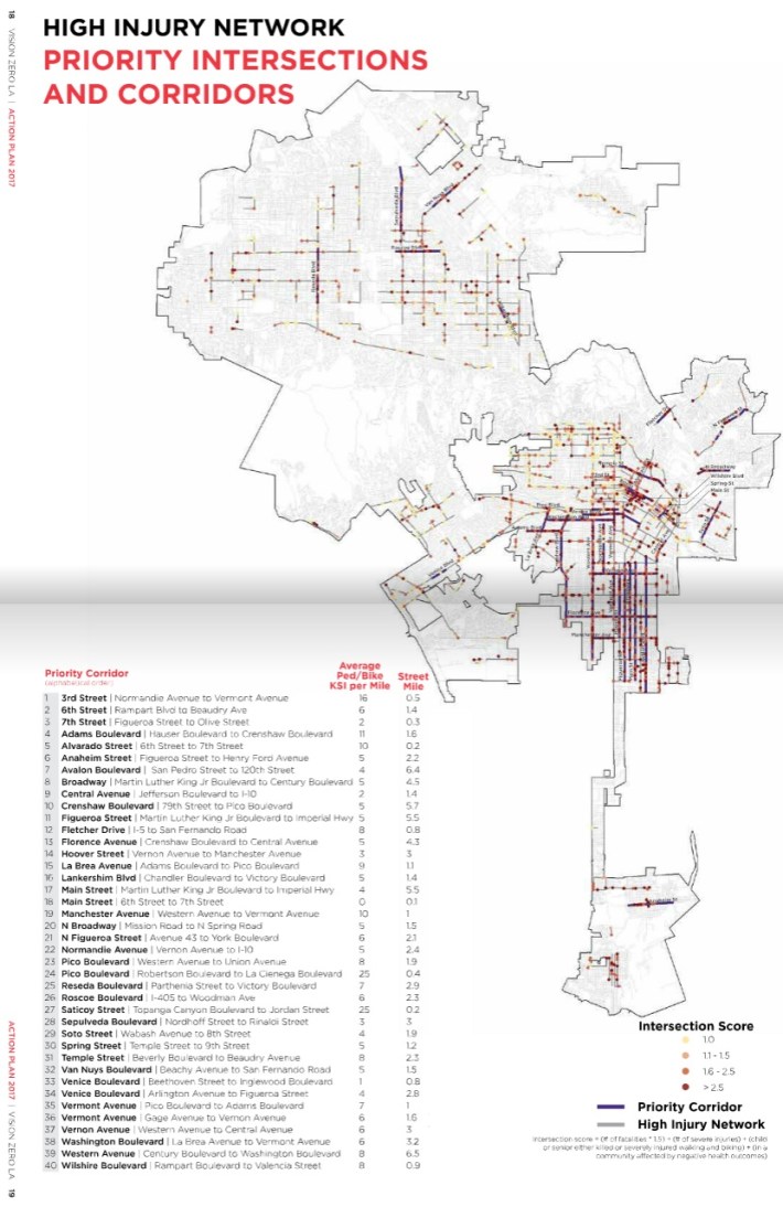
- Vision Zero: The city's Vision Zero initiative, from Garcetti's directive and the council's Mobility Plan, commits Los Angeles to ending traffic violence. The city's Vision Zero Action Plan identifies 40 priority corridors in the city's High Injury Network (seen above) where the city will focus on improving safety. Adding bike lanes to many of the 40 priority corridors will likely not be an end to improving safety there, but it would show that Garcetti and LADOT are taking steps to put on-the-ground actions behind promising Vision Zero talk.
- Bike network connectivity: In the past, especially during the Villaraigosa years, a lot of bike facilities were implemented opportunistically, more in places where there was plenty of excess space, and less where cyclists rode or where facilities could connect to each other. Now that there are significant miles of bike facilities implemented, it becomes important to close gaps between them.
- Transit connectivity: With Metro extending its rail network, it becomes more important to connect bicycle facilities to existing and future station sites. This helps solve transit's first-last mile challenge.
Omitted from the list are three long-standing facilities where councilmembers have blocked safety improvements: Westwood Boulevard, Central Avenue, and North Figueroa Street. These remain very worthwhile, but they do not appear to be implementable in the next couple years, assuming no change in leadership.
The projects are listed alphabetically within three categories:
- Easy bike lane projects - streets where bike lanes could be added with no (or in some cases very minimal) removal of space from cars. Theoretically, these "low hanging fruit" lanes should all be relatively easy, as they do not remove space from drivers. In practice, there may be some hiccups, so a committed bicycle-friendly Mayor and LADOT should be able to implement approximately 80-90 percent of this type of mileage very quickly - the current fiscal year or the next.
- Road diets - bike lanes that would need to reconfigure lanes, generally removing one car lane and adding bike lanes and a left turn lane. These projects require some community outreach and input, but the construction is just paint, so a bicycle-friendly Mayor and LADOT should be able to implement approximately 60 percent during the current fiscal year or next.
- Conversion to protected bike lanes - corridors with existing bike lanes that could fairly easily be upgraded to protected bike lanes. The city has done a handful of miles of basic protected bike lanes without needing any outside funding. These projects can feature phases - initial striping and bollard barriers - and then, if funding is available, features can be upgraded to include transit islands, bicycle signals and more. Given that these facilities already have bike lanes, upgrading them has minimal impact on drivers, so a bicycle-friendly Mayor and LADOT should be able to implement approximately 75 percent of first phase mileage very quickly - the current fiscal year or the next.
Easy Bike Lane Projects - 11.1 miles total
- Bellevue Avenue from Glendale Blvd. to Kensington - 0.6 miles in Echo Park. This facility would connect from Echo Park Lake to Sunset via Marion Avenue.
- Colorado Blvd. from the South Pasadena city limit (at Avenue 64) to N. Figueroa - 0.5 miles in Eagle Rock. This project would painlessly extend the existing Colorado Blvd. lanes. It is on LADOT's most recent bike project list, classified as "on hold."
- Echo Park Avenue from Bellevue to Altivo - 1.9 miles in Echo Park. This easy project would connect with bike lanes on Sunset. Northern portions of the project could include downhill sharrows with an uphill bike lane.
- Ivar Avenue from Franklin to Homewood - 0.7 miles in Hollywood. This wide street hosts the popular weekly Hollywood Farmers Market. On other days, it could serve as a safe bicycling street in a neighborhood with very little bicycle infrastructure.
- Lankershim Boulevard from Hatteras to Chandler - Vision Zero priority - 0.6 miles in North Hollywood. This would extend the existing Lankershim bike lanes to the North Hollywood Red/Orange Line Stations and Chandler bikeway.
- Marion Avenue from Kensington to Sunset - 0.1 miles in Echo Park. This would continue the Bellevue lanes listed above, connecting them with Sunset.
- McConnell Ave from Ballona Creek to Culver Blvd. - 0.3 miles in Del Rey. This existing sharrowed street should be upgraded to bike lanes, connecting to the Ballona Creek path.
- Roscoe Boulevard from the 405 Freeway to Woodman - Vision Zero priority - 2.3 miles in Panorama City. LADOT should remove peak-hour parking restrictions to add parking and bike lanes, prioritizing safety over throughput.
- Sepulveda Boulevard from Nordhoff to Rinaldi - Vision Zero priority - 3 miles in North Hills. This massively wide and unsafe street will not be transformed by adding bike lanes, but the lanes could be an easy early initial phase.
- Van Nuys Boulevard from Beachy to Laurel Canyon - Vision Zero priority - 0.8 miles in Pacoima. This would close a gap between existing bike lanes.
- Vermont Avenue from the 105 Freeway to 120th Street - 0.3 miles in South L.A. This short facility, located on the city/county border would serve the Green Line and close a gap between bike lanes on Vermont Avenue and on 120th Street.
- Winnetka Avenue from the Orange Line to Victory - 0.5 miles in Winnetka. The city should remove peak-hour parking restrictions to close the bike lane gap by connecting existing Winnetka lanes to the Orange Line and L.A. River paths, as well as Pierce College.
Road Diets - 21.7 miles total
- 1st Street from San Pedro Street to Alameda - 0.2 miles in Little Tokyo. This facility is planned as part of Metro's East Side Linkages project. It would extend the First Street bike lanes to the under-construction Regional Connector subway station.
- 6th Street from Fairfax to Cochran - 0.8 miles in Mid-City. This facility, championed by Mid-City leaders, would extend the popular existing 4th Street sharrowed bike route around Park La Brea.
- Alhambra Avenue from Valley Blvd. to the Alhambra city limit (near Lowell) - 1.3 miles in El Sereno. LADOT and Councilmember Huizar recently hosted a community meeting to study this project, which would add a center turn lane and provide for safe bike travel in a community with no bike facilities.
- Anaheim Street from Gaffey to Henry Ford - 3.3 miles in Wilmington. This project would form the east-west spine of Wilmington's extensive bike lane network, extending access east into Long Beach and west into Palos Verdes and San Pedro. The western portion of the project, along the Machado Lake park would be easy, but in downtown Wilmington it would require car lane removal. The project is on LADOT's most recent bike project list, classified as "conceptual."
- Avalon Boulevard from San Pedro Street to Slauson - Vision Zero priority - 1.4 miles in South L.A. This road diet would connect to Metro's planned Rail-to-River path. This had been Councilmember Curren Price's alternative to Central Avenue, though it serves a different population and does not replace the need for the Central Avenue facility.
- Barrington Avenue from Olympic to Navy - 1.1 miles in West L.A. This is one of the few potential corridors for a Westside north-south bikeway connecting to the Metro Expo Line path.
- North Broadway from Mission Road to N. Spring - Vision Zero priority - 1.5 miles in Lincoln Heights. LADOT should remove peak-hour parking restrictions to favor safety over throughput on Lincoln Heights' main drag.
- Crenshaw Boulevard from Pico to Exposition - Vision Zero priority - 1.8 miles in South L.A. These bike lanes would connect to Metro's existing Expo Line and the future Crenshaw Line.
- Fletcher Drive from San Fernando Road to Ripple/Crystal - Vision Zero priority - 0.7 miles in Atwater Village and Elysian Valley. This road diet would extend the recently-installed Fletcher Drive bike lanes to the L.A. River path.
- Florence Avenue from Crenshaw to Central - Vision Zero priority - 4.3 miles in South L.A. This east-west bikeway would connect to Metro's under-construction Crenshaw/LAX rail line.
- Holmes Avenue from Slauson to 51st Street - 0.5 miles in South L.A. This low-traffic street could extend existing L.A. County bike lanes.
- Hoover Street from MLK to Manchester - Vision Zero priority - 3.5 miles in South L.A. This is one worthwhile way to extend the MyFigueroa project southward, and to connect with planned lanes on MLK (see below).
- Hoover Street from Wilshire to Venice Blvd. - 1.2 miles in Pico-Union. Along with the Virgil facility (below), this would connect existing Hoover bike lanes near USC with existing Virgil bike lanes in East Hollywood.
- Hope Streer from north of 6th Street to below Venice Boulevard - 1.1 miles in downtown L.A. Hope Street has natural barriers (the Library and the 10 Freeway) which make it a relatively low-traffic alternative to parallel streets.
- Lankershim Boulevard from Chandler to Cahuenga - 2.0 miles in North Hollywood. This project is already partially underway. Extending the lanes the length of Lankershim would provide connections to the Universal City and North Hollywood Red Line Stations.
- Lorena Street from 3rd Street to Grande Vista - 1.5 miles in Boyle Heights. This project extends the existing Lorena bike lanes. It is on LADOT's most recent bike project list, classified as "conceptual."
- Main Street from MLK to 92nd Street - Vision Zero priority - 4.0 miles in South L.A. This project would extend the existing Main Street bike lanes.
- Martin Luther King, Jr. Boulevard from Marlton to Main - 3.7 miles in South L.A. This project closes the gap on MLK, and connects to MyFigueroa. It is on LADOT's bike project list, classified as "final design."
- San Vicente Boulevard from Wilshire to Orange - 1.8 miles in Mid-City. This useful diagonal closes the gap between existing bike lanes on San Vicente.
- Santa Monica Boulevard from Virgil to Vermont - 0.3 miles in East Hollywood. This connects several existing bike lanes with the Santa Monica/Vermont Metro Red Line Station.
- Soto Street from Huntington to 8th - Vision Zero priority - 3.7 miles in Boyle Heights. This key Eastside north-south corridor connects to the Metro Gold Line as well as several east-west bike lanes.
- Temple Street from Virgil to Figueroa - Vision Zero priority - 2.6 miles in Rampart and Echo Park. This would connect to DTLA and to the Virgil/Hoover lanes.
- Valley Boulevard from Mission to Marianna - 1.9 miles in Lincoln Heights. This useful and wide Eastside boulevard is on LADOT's most recent bike project list, classified as "conceptual."
- Virgil Avenue from Melrose to Wilshire - 1.5 miles in Rampart. This would extend the existing Virgil lanes south. Below Wilshire the facility would continue on Hoover lanes as listed above.
- Western Avenue from Washington to Century - Vision Zero priority - 6.5 miles in South L.A.
Conversion to Protected Bike Lanes - 30.8 miles total
- Colorado Boulevard from Eagle Rock to Eagle Vista - 1.1 miles in Eagle Rock.
- Crystal Springs Drive from Western Heritage to Los Feliz - 2.4 miles in Griffith Park. The city's largest park should have a safe comfortable route for families to ride on. The facility would continue onto Zoo Drive, in Griffith Park.
- Cypress Avenue from Eagle Rock Boulevard to Pepper - 1.3 miles in Cypress Park. This would continue on Eagle Rock Blvd.
- Eagle Rock Boulevard from Westdale to Cypress - 2.3 miles in Eagle Rock and Glassell Park. This would continue on Cypress Avenue.
- Forest Lawn Drive from Barham to Zoo Drive - 2.1 miles in Griffith Park. This park frontage road should feel more like a continuation of the park, instead of a high-speed thoroughfare. The facility would continues into Griffith Park on Zoo Drive.
- Main Street from Cesar Chavez to 9th Street - 1.4 miles in downtown L.A. The Spring/Main couplet project is already underway.
- Rampart Boulevard from 3rd Street to 6th Street - 0.3 miles in Rampart. The existing bike lane on this over-wide street is often cluttered with double-parking vehicles.
- Spring Street from Cesar Chavez to 9th - Vision Zero priority - 1.4 miles in downtown L.A. The Spring/Main couplet project is already underway.
- Venice Boulevard from Arlington to Venice Way - 9.7 miles in Mid-City, Mar Vista, Venice. A portion of the street (from Beethoven to Inglewood - a Vision Zero priority stretch) is underway as part of the Mar Vista Great Streets project.
- Western Heritage Way from Zoo Drive to Crystal Springs - 3.0 miles in Griffith Park. The facility continues on Crystal and Zoo.
- Winnetka Avenue from Devonshire to Victory - 5.0 miles in Winnetka and Northridge.
- Zoo Drive from Forest Lawn to Western Heritage - 1.9 miles in Griffith Park. Facility continues on Western Heritage.
As mentioned above, this three-part list includes plenty of key facilities, but is not a thorough comprehensive plan. Did SBLA miss worthwhile and relatively-straightforward bike projects readers want? Add your suggestions in the comments.
Overall Mileage
While there is some truth to LADOT's quality over quantity assertion, quantity still matters. Strictly focusing on quality tends to mean mostly upgrading existing bikeways, whether converting sharrows to bike lanes, or conventional bike lanes to protected ones. These upgrades are valuable (and generally easier than new mileage), but do not actually add any mileage to the city's bike network. With so much of the city lacking bike infrastructure, new mileage is needed to create a useful network.
If bikeway implementation was courageous (at no time has this been the case in Los Angeles), with Garcetti and LADOT truly focusing on priority safety corridors and strategically closing network gaps, then fewer new miles would be welcomed. All that said, if Garcetti is serious about making Los Angeles bike-friendly, here are some fiscal year mileage goals that would indicate significant progress.
- New bikeway mileage: 20 new (center-line) miles, at least one-third road diets
- Upgraded existing bikeway mileage: 25 upgraded (center-line) miles, at least half protected bike lanes
SBLA includes "center-line" as LADOT recently updated the way they count bikeway mileage, with one center-line mile now counting as two "lane-miles."
Upcoming Additional Articles in this Series
This is just the first article in series planned to outline what Garcetti can do to make L.A. more livable. Coming soon will be articles on additional bike matters: programs, policies, and more. Later posts will articulate a Garcetti agenda for walkability, including projects, programs, sidewalks, People St, and more.
If you have suggestions or tips for this series, send your ideas to joe [at] streetsblog.org.
Stay in touch
Sign up for our free newsletter
More from Streetsblog Los Angeles
Automated Enforcement Coming Soon to a Bus Lane Near You
Metro is already installing on-bus cameras. Soon comes testing, outreach, then warning tickets. Wilshire/5th/6th and La Brea will be the first bus routes in the bus lane enforcement program.

Metro Looks to Approve Torrance C Line Extension Alignment
Selecting the relatively low-cost hybrid alternative should help the oft-delayed South Bay C Line extension move a step closer to reality