
A Look At L.A.’s “Second Year” Bike Lane Implementation List
Last week, the Los Angeles City Departments of City Planning (DCP) and Transportation (LADOT) hosted a webinar for the start of what they're calling "2010 Bicycle Plan Second Year Implementation." The Webinar presentation materials are posted online here. SBLA covered some news from the webinar last friday. Today's article focuses on the "Second Year" projects and additional bikeway implementation discussed. The full Second Year facility list appears after the jump.
In 2011, city staff put forth a list of about 40 miles of "First Year" study corridors. These were streets where bike lanes had been approved in the 2010 Bike Plan, but the city deemed further study necessary. Since 2011, the city has studied all and implemented some of the "first year" corridors. In many cases, first year study corridor facility implementation has stalled due to political issues. The city has also implemented plenty of other bike lane projects: some approved in the bike plan, and some opportunistic.
In January 2014, the LADOT relased its Priority 2 list. The same list in slightly different form, called "Second Year Study Corridors," appeared on this handout distributed at DCP's planning forums. The second year study corridors are a list of about 40 miles of street segments where the city is looking to implement bike lanes soon. All of these bike lanes were already approved in 2011, when the city approved its bike plan.
The word "year" is somewhat confusing. Three years after adopting the bike plan, the city is starting on its "second year" bike lane projects. So, in this case, "year" means something more like "batch" or "grouping."
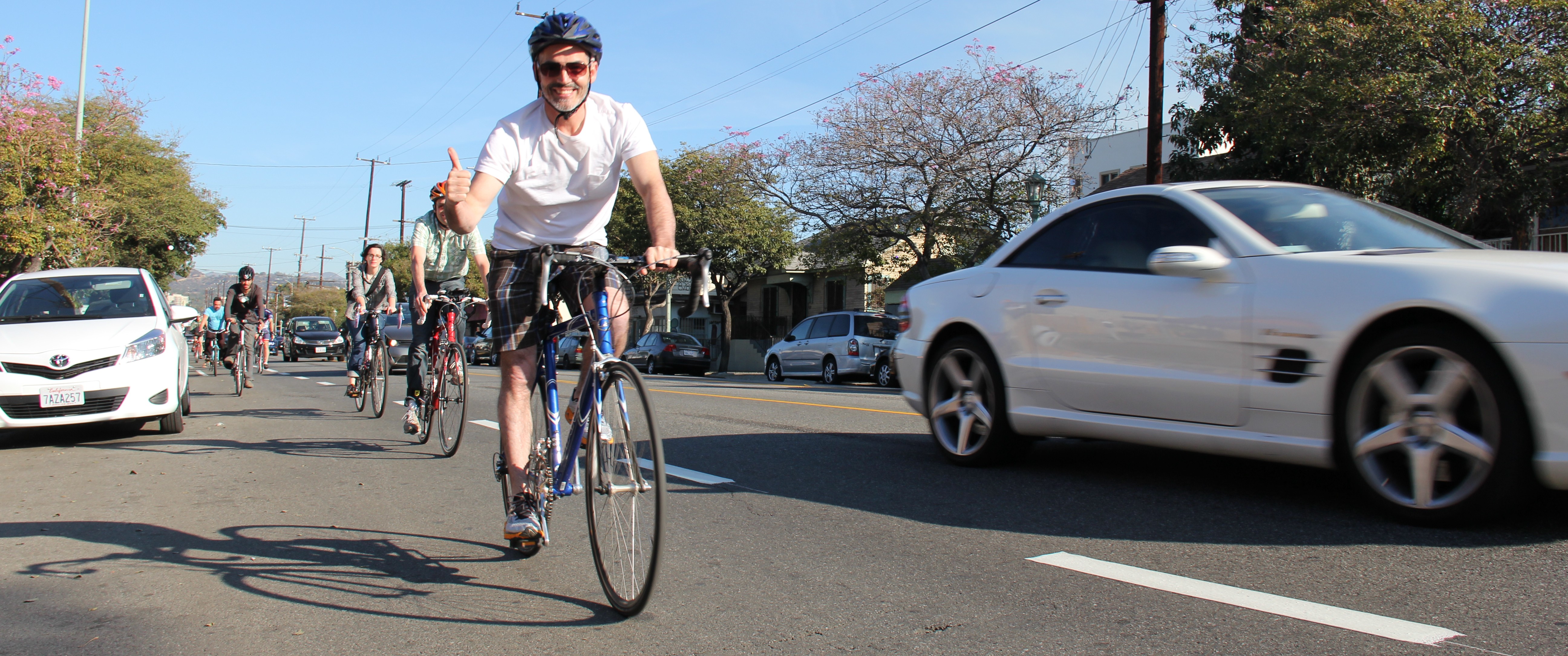
Though Streetsblog welcomes and celebrates bike lanes almost anywhere, some recent L.A. City bike lane mileage has been more opportunistic than strategic. Bike lanes on Via Marisol, Laconia Blvd, Braddock Drive, and Fair Park Avenue were all implemented more because the street was overly wide, as opposed to the lanes being particularly useful.
The city's "Second Year" list is much more strategic. Completion of these approved facilities will greatly enhance the city's bicycle transportation network. These corridors are places where L.A. bicyclists ride and need to ride, but where no safe and convenient facility exists. These facilities connect with others to create bike networks.
What's next for L.A. bike lane implementation?
Don't expect to see any of these lanes coming to a street near you right away.
The Second Year projects have been selected for technical studies because city staff anticipate that they "may reduce vehicle lanes" or parking. Though similar lane reductions generally improve safety for all road users, even drivers, taking things away can result in community backlash. This is especially true where Los Angeles communities distrust the city, including harboring skepticism of city technical expertise.
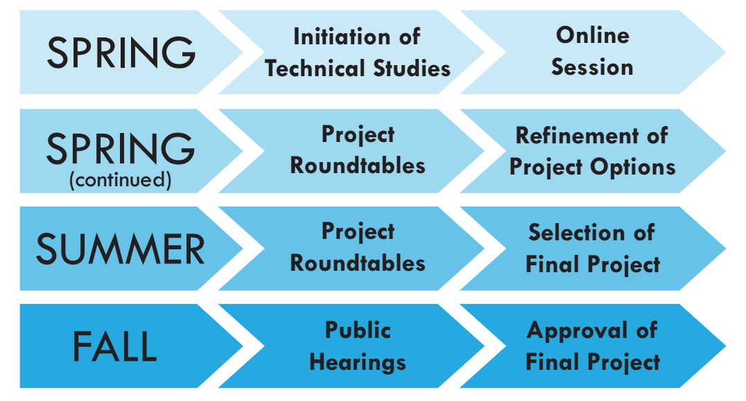
The "Second Year" facilities will undergo technical studies this spring and summer. Plans will be open to public input, and final designs are expected to be approved this fall.
These technical studies, if they're anything like past LADOT technical studies, will not focus on how safe or convenient or healthy or wonderful these lanes will be for bicyclists. The studies are unlikely to look at driver or pedestrian safety either. Nor air, water nor noise pollution. They won't look at the quality of the business environment, nor foot traffic. Nor quality of life. There's more likely to focus on "Level of Service" (LOS) which only predicts any adverse impacts to cars throughput. So the studies are likely to show some motorist delay, which can add fuel to the any constituencies opposed to making these streets safer.
If the difficulties and delays in implementing the "Year One" batch are any indication of future "Second Year" performance, then bicyclists, and others, will need to rally behind these bikeways to actually get them implemented.
With Second Year Bikeways A Ways Off, What's Next?
During last week's webinar, Streetsblog Los Angeles posted a question regarding what the next bike lane facilities LADOT would be opening this Spring or Summer. LADOT's Tim Fremaux responded that he wasn't sure. He didn't name a single bike lane facility expected to open soon.
Fremaux stated that the department had nearly exhausted the low hanging fruit bike lanes - lanes that could be implemented easily within existing roadway width without causing congestion, without removing needed travel lanes or parking. Unlike the "Second Year" list, low-hanging fruit bike facilities that don't require cumbersome car-congestion studies.
This "we're pretty much out of low-hanging-fruit" line has been a recurring response from LADOT. The 1996 Bicycle Master Plan referenced a lack of streets where lanes can be added without impacting traffic. During the 2010 Bike Plan process, LADOT asserted the lack of low-hanging fruit. DOT, then, until actual mileage commitments from a proactive mayor, turned around and implemented more than 150 miles of low-hanging fruit bike lane projects from 2010 until now.
Though there's less remaining low-hanging fruit today than there was in 2010, it's still out there. In an era of declining per-capita driving, in a city with lots of very wide over-built streets, there are still plenty of streets that can accommodate bike lanes with no controversy, no significant adverse impacts on car traffic.
The Second Year Bikeway List
The future bike lanes are listed in alphabetical rode by community area below. SBLA corrected city handout errors via this spreadsheet, and Google-mapped all of the "Second Year" segments here. For readability, SBLA has combined multiple facilities that form continuous corridors.
Boyle Heights
Boyle Avenue - from 5th Street to 8th Street (0.9 miles)
This stretch of Boyle is already a useful cycling street, crossing over and under three different freeways that otherwise serve as barriers to active transportation. The lanes will connect with Hollenbeck Park and with existing bike lanes on 8th Street.
Soto Street - Huntington Drive to 8th Street (3.7 miles)
Soto also crosses over and under barriers, including freeways and rail. The future facility will connect with bike lanes on Huntington Drive, 1st Street, and 8th Street.
Hollywood-Koreatown
Virgil Avenue / Hillhurst Avenue - from Wilshire Blvd to Los Feliz Blvd (3.4 miles total: 0.5 existing)
This facility would extend the existing lanes on Virgil Avenue. As Jeff Jacobberger noted, there are very few existing and planned facilities for population-dense and destination-rich Central Los Angeles. Extending Virgil's bike lanes (and implementing the Vine Street, Hollywood Blvd, 6th, San Vicente and Hoover lanes - see below) would form a very useful corridor in this area where space is tight, but generally short travel distances are conducive to bicycling.
Hollywood Boulevard / Sunset Boulevard - from La Brea to Fountain (3.6 miles)
This facility would extend the Sunset Blvd bike lanes across all of Hollywood's main commercial area. Though this area draws huge numbers of tourists, it's generally an underwhelming destination. Making Hollywood safer and quieter could be a big step toward revitalization, and could lay the groundwork for implementing tourist-friendly bike share there.
Vine Street - from Yucca Street to Melrose Avenue (1.4 miles)
Shortly after bike lanes were approved in the 2010 Bike Plan, this portion of Vine Street received sharrows, so this doesn't count as post-plan "new" bikeway mileage. The sharrows are a wholly inadequate bike facility, so actually implementing the approved lanes is needed. The Vine lanes would connect with L.A. bike-friendly Yucca Street the north, and with a useful bike route on Arden Boulevard to the south.
Mid-City
6th Street - from Fairfax Avenue to La Brea Avenue (1.0 mile)
These bike lanes would run between the County Art Museum and Park La Brea. With 4th Street Bicycle Boulevard ending at Park La Brea, 6th Street bike lanes would serve as a useful continuation route west.
San Vicente Boulevard - from Wilshire Blvd to Venice Blvd (2.3 miles total: 0.3 mile existing)
Like NYC's Broadway and L.A.'s Silver Lake, San Vicente is a useful diagonal cutting through a primarily gridded area. A portion of San Vicente from La Brea to Pico recently received bike lanes. According to the LADOT website map, more mileage is also coming soon from Wilshire to Beverly. This project will close those gaps between those facilities.
Hoover Street - from Venice Blvd to 7th Street (1.1 miles)
This project would extend the existing Hoover bike lanes all the way from USC to the 7th Street bike lanes.
South Los Angeles
Central Avenue - from 1st Street to 95th Street (7.2 miles)
This is the second longest segment on LADOT's list. The facility will connect to existing bike lanes on Central Avenue near the 105 Freeway, and extend them all the way to Little Tokyo. Central Avenue is an important historic street. Bike lanes would make it safer and more vital.
Vermont Avenue - from 79th Street to 88th Street (0.7 miles)
Vermont Avenue - from 105 Freeway to 120th Street (0.3 miles)
These two short stretches close gaps in the existing Vermont Avenue bike lanes.
San Fernando Valley
Woodman Avenue - from Roscoe Blvd to Sherman Way (1.4 miles)
This is a needed gap-closure on a very useful north-south street in the East Valley. Woodman also features innovative rainwater harvesting medians.
Parthenia Street - from Topanga Canyon Blvd to Kester Avenue (8.4 miles)
Parthenia isn't the most destination-rich east-west corridor through the middle of the Valley, but a continuous bike lane there should serve as a relatively fast commuter cyclist facility, and would be much more politically feasible than trying to shoehorn a bike lane onto a popular east-west commercial corridor, such as Sherman Way.
Westside
Westwood Boulevard - from Le Conte Avenue to Wellworth Avenue (0.5 miles)
This long-awaited facility would connect UCLA with existing Westwood Blvd bike lanes below Wilshire. Westwood is one of Mayor Garcetti's initial Great Streets Initiative sites. Though opposition stifled Westwood bike lanes further south, these lanes, at least north of Wilshire, appear feasible with minimal impact to other uses.
Barrington Avenue - from Olympic Blvd to Navy Street (1.1 miles)
McLaughlin Avenue - from Woodbine Street to Venice Blvd (0.7 miles)
Barrington and McLaughlin will form a worthwhile partially-sharrowed, partially-bike-laned corridor on the westside very near the future Expo Line. These lanes will connect with with existing lanes on Gateway.
Culver Boulevard - from Pacific Avenue to Jefferson Blvd (0.9 miles)
These bike lanes will provide access to the beach in Playa Del Rey.
Wilmington
Anaheim Street - from I Street to Henry Ford Avenue (2.3 miles)
Surprisingly, the harbor area has received a large number of bike lanes in recent years. What's missing from the emerging network are a few central commercial through-streets, including Anaheim Street.
Stay in touch
Sign up for our free newsletter
More from Streetsblog Los Angeles
Metro Board Funds Free Student Transit Pass Program through July 2025
Metro student free passes funded another year - plus other updates from today's Metro board meeting

Eyes on the Street: New Lincoln Park Avenue Bike Lanes
The recently installed 1.25-mile long bikeway spans Lincoln Park Avenue, Flora Avenue, and Sierra Street - it's arguably the first new bike facility of the Measure HLA era

