County Developing Plan to Add 138-miles of Multi-Use Paths on SGV Waterways
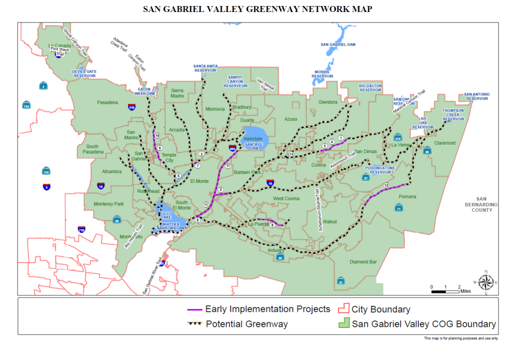
The Los Angeles County Flood Control District is currently working on a plan to open up more than 138 miles of SGV waterways to bicyclists and pedestrians. With the plan expected to be completed by Fall 2021, and the environmental review process being completed by Summer 2022, the San Gabriel Valley Greenway Strategic Implementation Plan would create a roadmap toward increasing open space in SGV communities and connecting to Rio Hondo and the San Gabriel Valley River.
“The plan will transform flood control district right-of-way within the San Gabriel Valley . . . into a world-class greenway network,” said Enrique Baul, a civil engineer with the Flood Control District during a presentation to the San Gabriel Valley Council Governments’ Technical Advisory Committee last week. “This plan will incorporate the needs of the communities and bridge gaps between existing planning efforts and it will identify and prioritize project opportunities.”
The plan builds on years of planning and actions by regional decision-makers and local stakeholders. In 2014, the SGVCOG and ActiveSGV, then known as BikeSGV, were awarded funding from the California Active Transportation Program to conduct a regional Greenway Feasibility Study to identify flood control channels, abandoned railways, and utility rights-of-ways to be transformed into bikeways, urban trails, and parks. This San Gabriel Valley Regional ATP Feasibility Study identified 50 miles of waterways best suited for greenways. In 2017, the Los Angeles County Board of Supervisors unanimously passed a motion to create the San Gabriel Valley Regional Greenway Network Implementation Plan.
So far, Flood Control District staff have completed a couple of analyses. They’ve mapped out which waterways have hydraulic concerns and analyzed the size of right-of-ways for the entire network. Areas that have greater hydraulic concerns may require diverting the route onto the street or fast-tracking the analysis in the project area to see what options are available along the route, Baul said. As for the right-of-way analysis — which took the width of the channel, compared that with right of way maps and took the difference of the two — Flood Control District staff is currently figuring out how much space they have available to accommodate the greenway.
The plan will also prioritize projects through two lenses: a community lens, which will identify where are communities with the highest density, are the most disadvantaged, have high pollution burdens and lack park space; and a circulation lens, which will see where retail, industry and schools are located along the waterways; where existing projects are happening; what regulatory constraints may exist within waterways being analyzed, and the complexity of a project and how that would affect or increase its cost. With a lot of work and studies already completed along certain waterways, that prior work can improve how a project is prioritized, Baul said.
A steering committee of 13 organizations convened in April and have been meeting monthly to provide input and guidance during the plan development. The groups include the Board of Supervisors offices in SD1, SD4 and SD5; Southern California Association of Governments, SGV Council of Governments, Rivers and Mountains Conservancy, LAC Flood Control District, LAC Public Works, Active SGV, Nature For All, SGV Conservation Corps, Native American Commission, and the Trust for Public Land.
Though the SGV Greenway Strategic Implementation Plan is still a few years out from being finalized, 13 projects have already started and are in various stages of development, including the Puente Creek Greenway and San Jose Creek Regional Access Multiuse Path. These roughly four projects are on a different schedule than the implementation plan, Baul said, and staff’s goal is to proceed with the plan development but not to hold back projects that have already started.
The SGV TAC is the first engagement with cities the project has done, Baul said, but LAC Flood Control staff will reach out to individual cities in the planning area to get their feedback. At the time of the meeting, only City of Pomona staff had been reached directly.
SBLA San Gabriel Valley coverage, including this article and SGV Connect, is supported by Foothill Transit, offering car-free travel throughout the San Gabriel Valley with connections to the new Gold Line Stations across the Foothills and Commuter Express lines traveling into the heart of downtown L.A. To plan your trip, visit Foothill Transit. “Foothill Transit. Going Good Places.”
Sign-up for our SGV Connect Newsletter, coming to your inbox on Fridays

Read More:
Streetsblog has migrated to a new comment system. New commenters can register directly in the comments section of any article. Returning commenters: your previous comments and display name have been preserved, but you'll need to reclaim your account by clicking "Forgot your password?" on the sign-in form, entering your email, and following the verification link to set a new password — this is required because passwords could not be carried over during the migration. For questions, contact tips@streetsblog.org.