L.A. Proposes Eliminating Parking Requirements Downtown
Today, the L.A. City Planning Department (DCP) released its full draft Downtown Community Plan, called DTLA 2040. Once approved, the plan would eliminate parking requirements for all of downtown Los Angeles.
DCP has been working on the new DTLA 2040 plan since 2014. It is the first city community plan update that incorporates the city’s new modular planning code, developed under re:code LA. DTLA 2040 is an update to two existing community plans: Central City and Central City North.
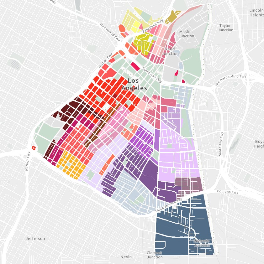
In July portions of the plan were released and covered at Curbed. Today, the department released an Interactive Zoning Map, Printable Zoning Map PDFs, Draft Zone components including: Form, Frontage, Development Standards, Use, Density and details of the new Community Benefits Program.
DCP will host two open house meetings this week for participants to learn about and give input on DTLA 2040:
- Saturday 11/2 – at 10:00 a.m. at Metro 417, 417 N. Hill Street in the Pershing Square area
- Tuesday 11/5 – at 4:00 p.m. at the Pico House, 424 N. Main Street at El Pueblo
According to the DCP announcement:
Under the proposed Plan, 60% of Downtown — compared to 33% today — would be eligible for residential uses. By the year 2040, Downtown will include 125,000 new residents, in addition to 55,000 new jobs — representing 20% of the City’s population growth in 1% of its land area. The Plan would accommodate this growth through new land use strategies that reinforce Downtown’s economic base, strengthen linkages between neighborhoods, and incentivize residential units.
One noteworthy change is that DTLA 2040 eliminates parking requirements (mandatory off-street parking minimums for new development) for the entire downtown plan.
This, of course, does not mean that parking will disappear downtown. Or that multiple new zero-parking developments will arrive any time soon.
Eliminating parking minimums just means that developers can decide to include as much or as little parking as makes sense for new developments. Some affordable housing may be built with very little parking. Some luxury developments may still include plenty of parking. But the decisions as to how much parking to include will be made by developers and not by the city.
Eliminating parking requirements was already done for portions of downtown Los Angeles. In the late 1990s, the city passed its adaptive reuse ordinance which eliminated parking requirements for development that preserves existing (historic) downtown buildings. In 2012, L.A. approved the Cornfield Arroyo Seco Plan which eliminated parking requirements in the north end of DTLA 2040.
In recent years, numerous cities have realized that parking minimums are bad for housing affordability and for the environment. Many U.S. cities have eliminated parking requirements – either citywide or for central districts. Examples include: Lancaster, Santa Monica, San Diego, San Francisco, Houston, Cincinnati, and many others.
Some groups have opposed wholesale elimination of parking requirements, as in some cases it can enable luxury housing development and gentrification. City Planning has included policies to foster supportive and affordable housing projects in new Skid Row area zoning, as well as fostering affordability via the new Community Benefits Program. (For this article, SBLA reached to some downtown nonprofits none of which were able to comment on the newly released plan’s parking policies.)
The earliest the new plan will go into effect will be about a year from now – late 2020. DCP plans to release its draft Environmental Impact Report in early 2020. After that the plan will need to be approved by the City Planning Commission, Mayor, and City Council.

Read More:
Streetsblog has migrated to a new comment system. New commenters can register directly in the comments section of any article. Returning commenters: your previous comments and display name have been preserved, but you'll need to reclaim your account by clicking "Forgot your password?" on the sign-in form, entering your email, and following the verification link to set a new password — this is required because passwords could not be carried over during the migration. For questions, contact tips@streetsblog.org.