Note: Metropolitan Shuttle, a leader in bus shuttle rentals, regularly sponsors coverage on Streetsblog San Francisco and Streetsblog Los Angeles. Unless noted in the story, Metropolitan Shuttle is not consulted for the content or editorial direction of the sponsored content.
Remember last week's study that found congestion pricing could meet lots of environmental, equity, and congestion goals for the Westside? That study that several Westside interests criticized? There's more to it than just the Westside.
Road pricing is already working in other parts of the world - from Singapore to London to Stockholm. Since last week's study came out, New York finally approved congestion pricing for lower Manhattan. That took over a decade of advocacy. Many other big cities are considering congestion charges; these places include San Francisco, Seattle and Philadelphia. Metro is studying congestion pricing, but before any sort of pilot would get approval plenty of naysayers will need to be convinced of its worth.
For folks not at all familiar with congestion pricing or cordons, perhaps start with this TED Talk telling Stockholm's story.
Congestion pricing comes in several flavors, and different programs and studies define terms differently. Congestion charges can be based on:
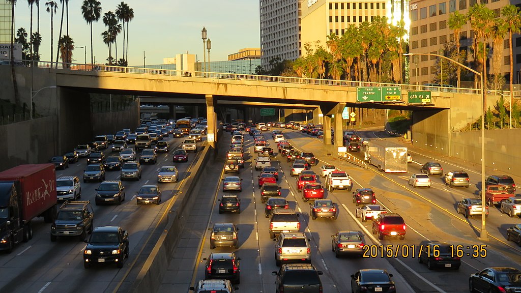
- Corridor - L.A. already has a version of corridor congestion pricing in its freeway ExpressLanes on the 10 and 110 Freeways. Express lane tolls are higher at peak hours; lower at un-congested times. Toll revenue goes to strengthening alternatives to driving, including improved Metro Silver Line bus service. Metro is studying a more robust version of corridor pricing where pricing would apply to all lanes and revenues would go to subsidizing transit service in the corridor.
- Cordon - Cordon pricing, such as in Stockholm, defines a boundary around a destination area, then charges drivers to cross that boundary. More on this below.
- Mileage - New VMT (vehicle miles traveled) charges, such as a Mileage-Based User Fee as California and Oregon have piloted, could charge higher for mileage at congested times and in congested places.
- Indirect - There are several ways that other fees and prices serve as a partial indirect proxy for congestion charges. These include pricing driving through parking costs, ride-hail fees, gas tax, etc. Where these prices are kept artificially low, driving is encouraged and congestion typically follows. Depending on how these sorts of fees are set up, they can encourage different transportation behaviors.
That recent Mobility Go Zone & Pricing Feasibility Study (full pdf) was conducted by the Southern California Association of Governments. SCAG does transportation planning for a six-county regional area. Their recent study specifically looked at cordon congestion pricing.
Cordon pricing certainly works in many places around the world. But, in addition to the political unpopularity that congestion pricing faces prior to implementation all over, cordon pricing faces some additional challenges in Southern California.
Unlike Manhattan, San Francisco, and Stockholm, Southern California does not have natural cordon boundaries. Cordons are easier to conceive of when there are natural boundaries being crossed, such as bridges leading onto island. Southern California is said to be polycentric, with downtown L.A. being one important regional employment center among many. So it is not quite obvious exactly where a cordon would work best.
Another tricky caveat in selecting boundaries is the complexity of overlapping jurisdictions. Roads are governed mostly by underlying municipalities, mostly cities. Freeways running through cities are mostly governed by the state, with some federal oversight. Drivers are, of course, not particularly concerned when their commute takes them from a city street to a state highway, but pricing one of these and not the other could have consequences in pushing congestion around instead of reducing it.
Multi-jurisdiction projects would require approvals at multiple levels. L.A. cordon pricing could potentially need approvals from multiple cities, as well as county, Metro, state, and federal governments. Multi-jurisdiction revenue also likely means a political struggle to determine who gets funding for what.
SCAG specfically studied cordons for "geographic areas involved experiencing congestion on arterial roadways, as opposed to highways." This unfortunately sounds like the proverbial drunkard searching in the wrong place. Can Southern California make significant progress on reducing car congestion without looking at freeways? SCAG does have other studies and plans that outline ExpressLanes for tolling some highway travel.
The study primarily focused on the city of Los Angeles "and immediately adjacent areas generally perceived to experience high levels of congestion during at least part of a typical week." From there study looked at where cordon pricing is "generally suited" to reduce congestion "caused by a high level of demand for trips to and from a defined geographic area."
SCAG looked at eleven potential cordons. It recommended five cordons for further study and recommended against six other proposed cordons.
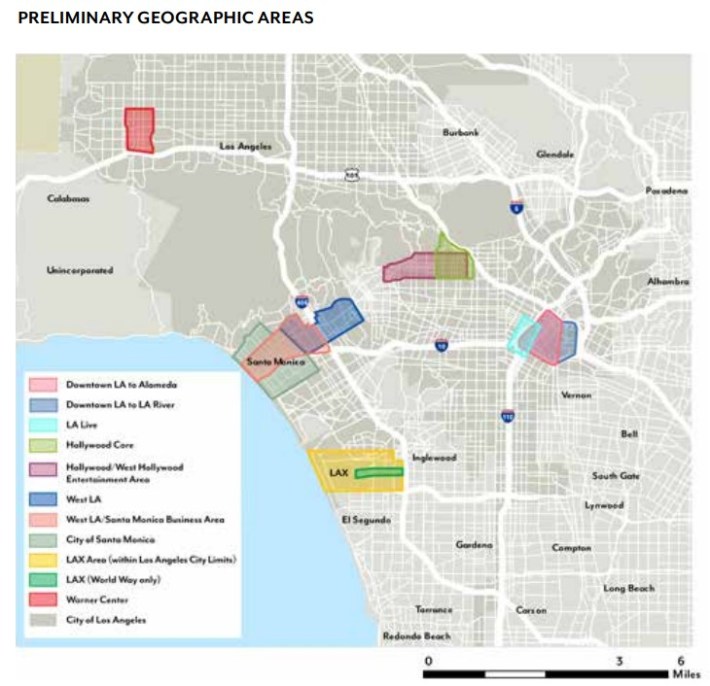
Potential cordon congestion pricing areas recommended for further evaluation were:
- Downtown L.A. to Alameda (bounded by 101 Freeway, Alameda Street, 10 Freeway, and 110 Freeway) "recommended for further evaluation but questions remained about whether to include or exclude trips on the downtown freeway ring."
- L.A. Live (bounded by Olympic Boulevard, Flower Street, Washington Boulevard, and Union Avenue) "recommended for further evaluation with reconsideration of boundaries and type of pricing tool, potentially tying to sale of tickets."
- West L.A. (bounded by San Vicente Avenue, Wilshire Boulevard, Beverly Hills City Limit, Pico Avenue, and Centinela Avenue - Santa Monica City Limit) "Recommended for further evaluation but should include parts that focus on employment core with congestion as this area has a large employment base and residential population. Congestion in Century City is largely limited to the major roadway approaches (Santa Monica and Olympic Boulevards) with less congestion on internal roadways."
- West L.A./Santa Monica Business Area (bounded by Montana Avenue, 405 Freeway, 10 Freeway, and the Pacific Ocean) "recommended for further evaluation but should include parts that focus on employment core with congestion as this area has a large employment base and residential population."
- City of Santa Monica (bounded by city limits) "recommended for further evaluation but should include parts that focus on employment core with congestion due to the broad definition of the charging area."
Not recommended were:
- Downtown L.A. to L.A. River (bounded by 101 Freeway, L.A. River, 10 Freeway, and 110 Freeway) "not recommended for further evaluation due to insufficient amount of trips beginning and ending east of Alameda Street to justify a larger downtown cordon."
- Hollywood Core (bounded by 101 Freeway, Highland Avenue, Franklin Avenue, Wilton Place, Melrose Avenue, and La Brea Avenue) "not recommended for further evaluation as not enough trips were attracted to this area under existing conditions and expected future development growth. Additionally, a large share of traffic has both origin and destination outside of the potential charging area."
- Hollywood / West Hollywood/ Entertainment Area (bounded by Sunset Boulevard, Franklin Avenue, Gower Street, Melrose Avenue, and Doheny Drive) "not recommended for further evaluation as large share of trips would be limited to weekend or nighttime only. As an entertainment/event-based alternative, the LA LIVE scenario showed more potential."
- LAX Area (within L. A. City Limits - bounded by Manchester Avenue, La Cienega Boulevard, 105 Freeway, and Pershing Drive) "not recommended for further evaluation due to many one-time or occasional visitors accessing this area. The airport’s periods of peak demands do not coincide with general roadway peak demands so would not alleviate regional congestion. Additionally, extreme jurisdictional complexity was expected to coordinate LA County and the Cities of Hawthorne, El Segundo, and Inglewood."
- LAX (World Way only - bounded by Sepulveda Boulevard) "not recommended for further evaluation due to many one-time or occasional visitors accessing this area. Additionally, this area may conflict with the federal Passenger Facility Charge."
- Warner Center Specific Plan Area (bounded by Vanowen Street, De Soto Avenue, 101 Freeway, and Topanga Canyon Boulevard) "recommended for further evaluation despite having very high trip attractions as roadway capacity is also much higher than in many other areas evaluated."
Ultimately, the authors of the study chose Westside areas as showing the greatest potential due to large employment bases in West LA and Santa Monica - including "a relatively large share of the employment is in industries requiring highly skilled workers."
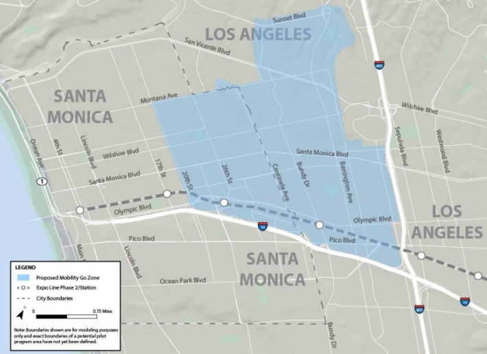
Readers - what do you think? Where would you draw the boundary line for a congestion pricing cordon in Southern California? What boundaries make the most sense?
And ultimately how do those boundaries affect not only congestion - but how can a Southern California cordon congestion pricing program best foster equity? Congestion pricing cuts two ways for low income Angelenos. Low income transit riders would see big benefits including better service and lower (potentially free) fares; low income drivers would see their transportation costs increase. The SCAG report calls for a discount program, similar to Metro ExpressLanes Low-Income Assistance Plan, which is not defined in detail, though the report suggests charging eligible low income drivers 50% of what other drivers pay. Given the costs and benefits, it will be important to design a congestion pricing program so that its benefits go to low income people and neighborhoods and not just well-off ones.
