These London Trains Have Real-Time Displays to Reduce Crowding
Sometimes it’s astounding how rider-friendly transit service has become in other countries compared to America.
In the U.S., even the biggest transit agencies have yet to put trains into service with open gangways, which let passengers spread out more evenly. Meanwhile, these types of trains have become standard in other parts of the world, and transit agencies are figuring out new ways to take advantage of them to improve the rider experience.
Dan Malouff at Greater Greater Washington shares this example from Thameslink, a regional rail service in London and its suburbs:
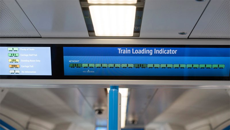
Take a look at this sign inside a British Thameslink commuter train. It tells riders which railcars are most crowded, so they can walk to a less crowded car.
The signs are on Thameslink’s newest trains, and work via a “load weigh system” that estimates crowding based on the weight load inside each railcar.
Combined with Thameslink’s open gangway layout that allows passengers to walk from car to car without leaving the train, the system increases the functional capacity of the whole train for very little cost. Far less cost than more trains or more tracks, certainly.
And like real-time train or bus arrival information, it’s easy to imagine this sort of info being incorporated into smartphone apps. If that happens, riders would be able to pick a spot on the platform where they know the least crowded railcar will arrive.
More recommended reading today: The Dallas Morning News gives the Trinity Toll Road, an urban highway proposal that city residents have been fighting for years, about a week to live. And Bike Portland says the NTSB’s new report on speeding validates the city’s Vision Zero initiatives.

Read More:
Streetsblog has migrated to a new comment system. New commenters can register directly in the comments section of any article. Returning commenters: your previous comments and display name have been preserved, but you'll need to reclaim your account by clicking "Forgot your password?" on the sign-in form, entering your email, and following the verification link to set a new password — this is required because passwords could not be carried over during the migration. For questions, contact tips@streetsblog.org.