Metro West Santa Ana Branch Light Rail Alignments Narrowed
Today Metro’s Planning and Programming Committee approved four specific West Santa Ana Branch light rail alignments to be used for environmental studies.
The West Santa Ana Branch is a historic Pacific Electric Streetcar right-of-way that runs diagonally through southeast L.A. County cities including Paramount, Bellflower and Artesia. Measure M includes funding for two phases of light rail on the West Santa Ana Branch, with the line ultimately expected to run from Union Station to the city of Artesia.
In September 2016, the Metro board approved a four-year $12 million contract with Parsons Brinckerhoff to complete environmental clearance work for the line. The environmental clearance studies follow several earlier preliminary studies by the Southern California Association of Governments and Metro.
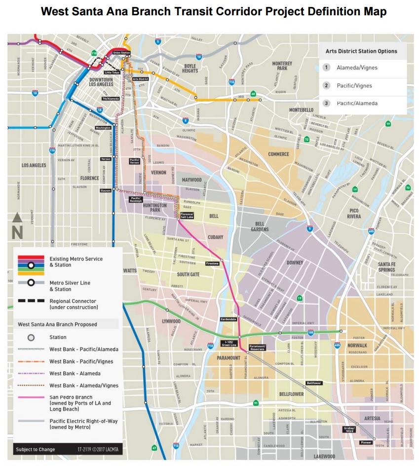
The southern portion of the line runs on a very clear off-street rail right-of-way. The alignment for the northern portion, connecting to Union Station, has not been finalized. With various options including extensive aerial tracks and subway tunnels, the northern portion looks like it will be relatively expensive.
Today, the committee approved further study on four alignments for the northern portion of the line, two along the Pacific Boulevard corridor, two along the Alameda Street/Blue Line corridor. Metro labels the alignments as follows:
- Pacific Boulevard/Alameda Street
- Pacific Boulevard/Vignes Street
- Alameda Street
- Alameda Street/Vignes Street
The four alignments are mapped below.
Metro plans to scope their Environmental Impact Report this spring, then prepare the full EIR, which the agency expects to approve in late 2019.
For additional details, see Metro’s article at The Source and Metro’s project page.

Streetsblog has migrated to a new comment system. New commenters can register directly in the comments section of any article. Returning commenters: your previous comments and display name have been preserved, but you'll need to reclaim your account by clicking "Forgot your password?" on the sign-in form, entering your email, and following the verification link to set a new password — this is required because passwords could not be carried over during the migration. For questions, contact tips@streetsblog.org.