Eyes on the Bridge: What Glendale-Hyperion’s Missing Sidewalk Means
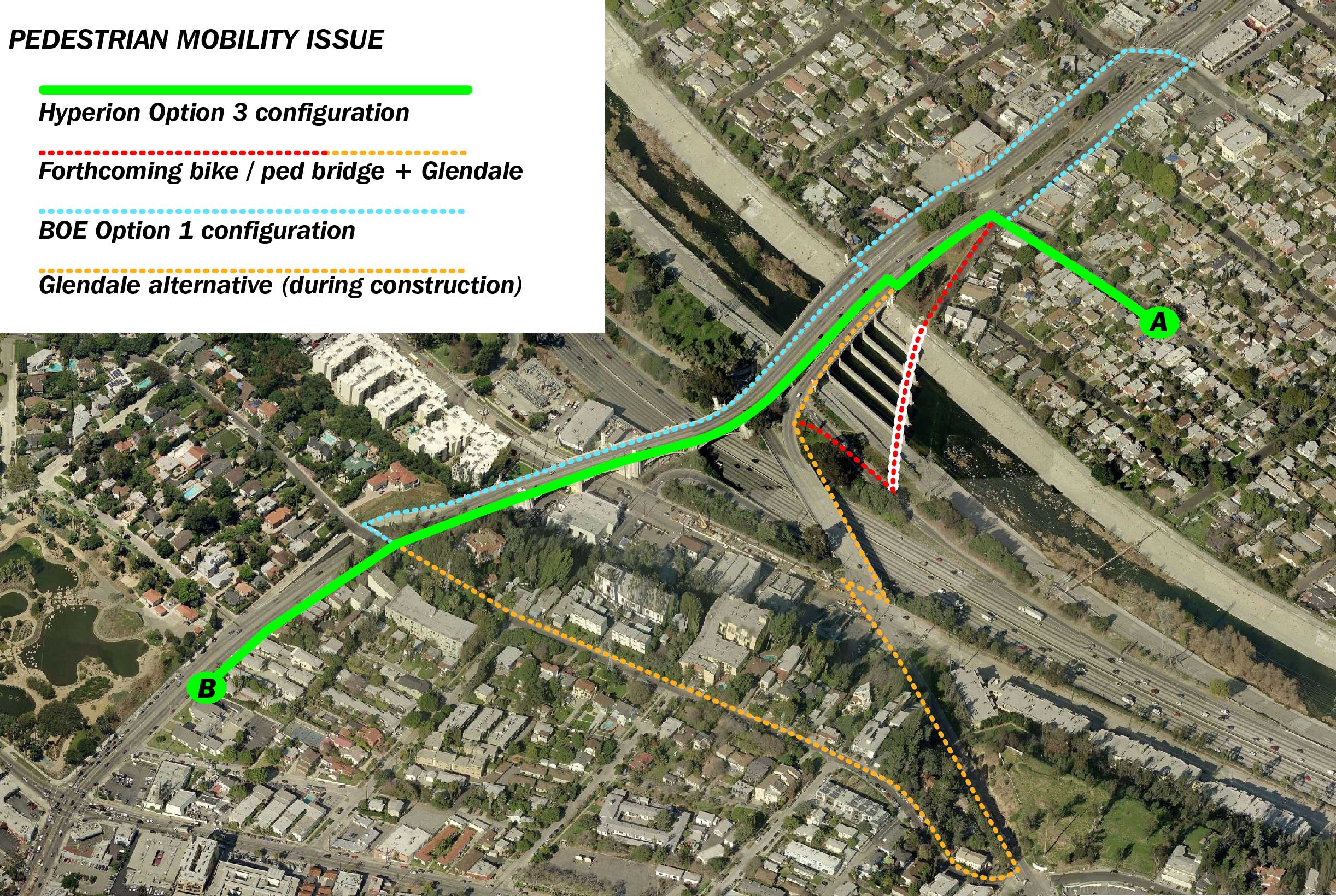
Above is a graphic created by Don Ward to show just how crappy the Bureau of Engineering’s Glendale-Hyperion Bridge plan is. The unsafe design was recently approved by L.A.’s Board of Public Works, and will soon come before City Council. Streetsblog USA profiled the board’s approval as a sign that Los Angeles Mayor Eric Garcetti’s commitment to great streets may be illusory.
According to Ward:
I made this chart to explain the route of an actual petition signer in Atwater who walked from her house (approximate location A) to her church at B. She was interested in safer access to the south sidewalk and did not want to have to walk an additional half mile or so to get to her destination. The shortest possible route under Option 1 would include walking up a steeper incline to the top of Waverly to get across Hyperion on the Silver Lake side.
This also illustrates how disingenuous it is for the city to claim that the new bike-ped bridge creates better mobility by connecting to Silver Lake. The bike-ped bridge is great to get to the L.A. River bike path, but the south Glendale bridge serves the same purpose.
The key decision-maker at this point could be incoming Los Angeles City Councilmember David Ryu, who won yesterday’s run-off election. Ryu will replace Tom LaBonge on the City Council.
LaBonge has been an outspoken advocate of “Option 1”, the city’s plan to have four traffic lanes, two small bike lanes and one sidewalk on the new bridge. However, Andrew Adams, Ryu’s campaign manager, read a letter from Ryu at last week’s Public Works hearing that the councilman-elect would prefer the more pedestrian friendly option 3.
“This option has wide community support and many dedicated community members have been working for over a year and a half on this issue,” wrote Ryu. “From sidewalk access for students walking to school, to families seeking to travel by foot to local businesses, I believe “Option 3″ is the best option to help meet the mobility needs of our community”

Read More:
Streetsblog has migrated to a new comment system. New commenters can register directly in the comments section of any article. Returning commenters: your previous comments and display name have been preserved, but you'll need to reclaim your account by clicking "Forgot your password?" on the sign-in form, entering your email, and following the verification link to set a new password — this is required because passwords could not be carried over during the migration. For questions, contact tips@streetsblog.org.