Most of the city of Los Angeles' bike lane mileage has been implemented without removing any car lanes or any parking spaces. The city Transportation Department (LADOT) merely narrows existing overly-wide lanes, and adds bike lanes. In recent years, the city of Los Angeles has also done a number of bike lane projects called "road diets." These road diets do remove a travel lane.
For a road diet, LADOT generally removes one roughly-10-foot-wide travel lane and replaces it with two 5-foot-wide bike lanes. The Federal Highway Administration (FHWA) has extensively studied road diets and found that they make streets safer for pedestrians, cyclists, and people in cars.
Here are some recent LADOT road diet examples - not an exhaustive list:
- 7th Street in central Los Angeles - from Koreatown to Downtown
- Main Street in Venice
- York Boulevard and Colorado Boulevard in Eagle Rock
On many streets with excess capacity relative to current traffic volumes, these projects can be non-controversial. Sometimes, especially in commercial areas with many driveways, they are welcomed, because they facilitate easier turning. Sometimes lane removal can be controversial, when it is perceived as reducing capacity for cars.
But what about parking? Do Los Angeles road diets remove parking?
Well, by definition, a road diet is reducing a travel lane. So, no, road diets don't remove parking, they remove a travel lane.
In many cases, L.A.'s road diets have actually freed up space for additional parking--although sometimes LADOT doesn't take advantage of this.
LADOT has been under pressure from the 2011 mayoral directive to build more bike lanes. This urgency has resulted in some projects overlooking possibilities for reworking curb parking in light of the new road configuration. Not maximizing available curb parking can make it a little more difficult for drivers to park, and, in areas with parking meters (including the south side of 7th Street in the example below,) this means that the city could potentially be foregoing some revenue.
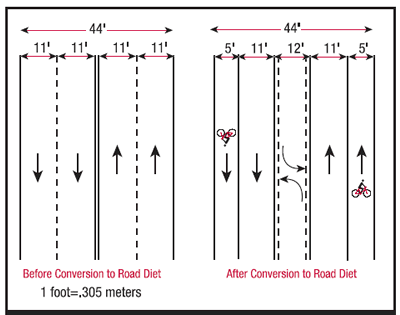
The most common road diet, diagrammed above, starts with a four-lane street (with two travel lanes in each direction.) The diet removes one of those lanes, resulting in a three-lane street, with one travel lane in each direction, and one center turn lane.
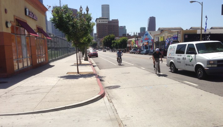
7th Street at Union Street in Pico Union, shown in the photo at the top of the post, is an example of where a road diet frees up space for additional parking.
The 7th Street example is essentially the same as the FHWA diagram above, but the street has additional width, mostly allocated to on-street parking. This portion of 7th Street received a road diet and bike lanes in 2011. Prior to the road diet, 7th Street had two car lanes in each direction. After the road diet, it had one car lane in each direction, plus a continuous center turn lane.
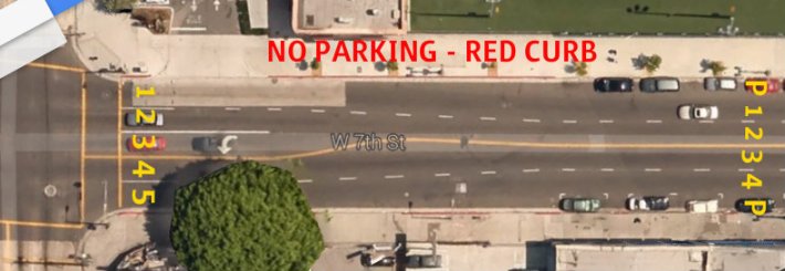
Historically, LADOT often flares the four lanes outward at many intersections, removing parking on both sides of the street to make room for a center left-turn lane. So, at intersections , the street has five lanes and no parking - see above image. Prior to 2011, on 7th Street at Union Street there were five lanes of traffic and no curb parking along the area where the lanes flared out.
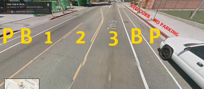
When the number of lanes is reduced from four to three, there is often new room for parking near intersections.
Actual road diets, by definition, reduce traffic lanes. They don't reduce on-street parking, and in some cases they can increase it.
