
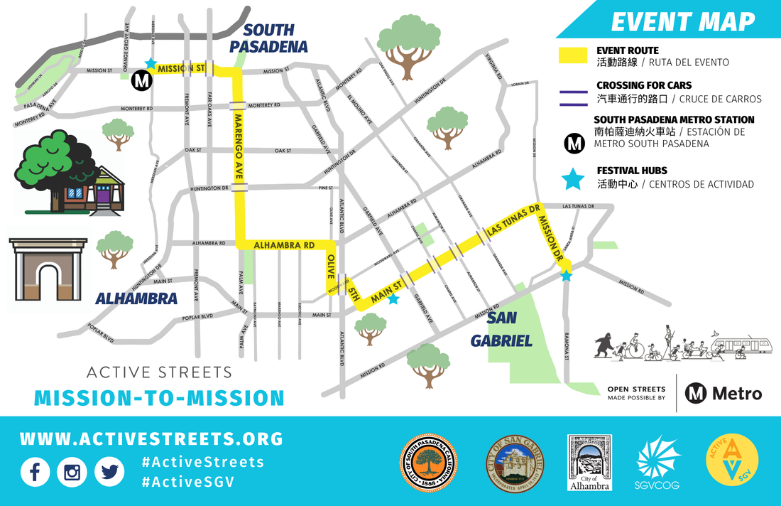
L.A.’s Draft Bikeway Plan: Non-Committal, Sloppy and Perhaps Illegal
 Shouldn't this map have street names? Oh... now it does! All Image via labikeplan.org
In September 2009, the city of Los Angeles released its draft Bicycle Master Plan update. This followed the May 2009 release of slightly different facility map portions of the plan. The public is invited to four meetings later this month to learn about and give input on the draft plan.
The blogosphere has quite a few critiques of the plan including those by Stephen Box, Alex Thompson, Green LA Girl, and Dan Gutierrez. L.A. StreetsBlog has run various reviews (including one by this author) of the initial May 2009 maps, and last week featured Box's scathing article which declared that the plan "fails on three levels, based on content, based on process, and based on commitment."
The plan has a wide assortment of specifics - from mountain biking
policy to signage specifications to commuting statistics, and much
more. This article analyzes and enumerates problems with the bikeway
facilities listed in the plan. The draft bikeway facilities are:
non-committal in their language, sloppy, and perhaps illegal. Details
follow after the jump.
Many Los Angeles bike advocacy successes in recent years have stemmed from facilities designated in the 1996 Bicycle Master Plan. These include bike lanes on Reseda Boulevard, Silver Lake Boulevard, Sunset Boulevard, and others.
Many of the plan's technical specifics end up being fairly
malleable. For example, the 1996 Bicycle Master Plan approved a
"program for meter mounted bicycle parking" but when LADOT bikeways
staff encountered resistance on this, they, without amending the bike
plan, smartly shifted to the familiar inverted-U racks.
Hence the facilities are a very critical part of the plan.
Bike Facility Language is Non-Committal
When the initial May maps were released, bicyclists reacted strongly
to the classification of "currently infeasible" for most of the
bike-lane-designated streets from the city's 1996 plan. Bike activists
responded that this "infeasible" wording was inappropriate. The new
September maps, contained in chapter 4 of the draft plan, responded to
bicyclist concerns by changing the wording from "infeasible" to
"potential" bike lanes.
In comparing the 1996 plan to the 2009 draft, the city's language
for all bikeways has been downgraded. The 1996 plan shows bikeway
facilities as "designated" while the current draft update calls them
"proposed." If the city is serious about completing these planned
facilities, it should carry forward the designation language into the
current plan.
Bike Facility Chapters Are Sloppy
There are actually two different versions of the city bike plan
on-line, and they're different, depending on how one accesses them. One
can download the entire plan in one fell swoop, or download it
separately chapter by chapter.
Here's a detail of page C9 downloaded as part of the entire plan:
 Page C9 detail
Here's the very same page C9 downloaded as part of just Appendix C:
 The very same Page C9 detail, but looking different.
These look very different, no? Which of these is available for
review at the city's libraries? Perhaps the public should be given 45
days to review each version - so 90 days in total? These two appear to
possibly be the same document, just sorted differently... or maybe one
sorted and one randomized... but the author didn't have time to verify
if they're actually the same list. Perhaps one of them has more
bikeways than the other... difficult to tell.
Page citations in this article are based on the 2nd version - the
separately down-loadable version - the one sorted in no discernible
order. Your results may vary if you download a different version than
the author.
Has any bicyclist out there ridden on the city's Avenue 88? Probably
not, because it turns out that there is no Avenue 88 in Los Angeles.
That doesn't stop the draft (p. C-19) from designating... er...
proposing that bike lanes should go on Avenue 88.
How about Chanlder Blvd? Wiill Rogers Street? Sanland Blvd? Tenesse
Ave? Murfield Road? These are typos, of course, and this author will
probably have a typo in this article. In addition to their role in
serving to promote Will Campbell's bike blog [sic], the errors make it difficult to search the document electronically.
The list of existing bike routes (page C-6 to C-8) is especially
riddled with errors. It's missing the mile lengths for all these
facilities. Many of the facilities are just wrong: has anyone biked the
existing bike route on 4th Street from Olympic Blvd to Boyle Av?
Probably not, because 4th doesn't actually intersect Olympic in Los
Angeles. How about Griffin Avenue (located in Highland Park) from
Burbank Blvd to Hartsook Street (both in the Valley)? No wonder they
lack mile lengths... because these and another dozen or so listed just
don't make any sense.
Then there are the maps.
The maps lack portions of the western end of the San Fernando
Valley. Perhaps it's an honest error - it's difficult to fit the whole
Valley onto 6 pages... but it actually drops an existing bikeway from
the plan - the bike lanes on Burbank Blvd from Valerie Avenue to Valley
Circle Blvd. A portion of Pacific Palisades is similarly omitted,
dropping part of the planned extension of the beach bike path.
 Introducing the Metro Gray Line?
The maps show a mysterious gray line running horizontally through
the north Valley... perhaps it's a veloway? a new freeway? high speed
rail? or just a distraction?
The existing bike paths shown in the Sepulveda Basin are incorrect. It shows a bike bridge over the LA River that doesn't exist.
The Valley and South L.A. maps include street names, but the West and Central L.A. maps don't.
It now appears that the city has changed the maps since the original files were posted;
today West and Central have street names. See for yourself - the old
version is shown at the top of this article. The new maps are in Chapter 4 here.
This alteration, presumably done with good intent (to fix an error)
brings up some questions: shouldn't document changes trigger at least a
new 45-day review period? Shouldn't the review period start after the
city finishes making changes to the documents that it has released? How
do cyclists know that the city didn't downgrade another bikeway
facility while they were revising the maps? The city did these sorts of
downgrades between the May and September map versions - for example
York Blvd went from Bike Friendly Street to Potential Bike Lane. Did it
do additional downgrades between the September and October maps? It
would build trust if the city would openly and transparently announce
these sorts of post-release changes. The city should also leave the old
versions on-line, so that bicyclists could double-check them.
The maps are inconsistent with the bikeway listing in the appendix.
For example, on page C-16, Woodman Ave from Sherman Way to Chanlder
[sic] Blvd is listed as a "proposed" bikeway so it should be in green,
but the map shows it in orange, the color for a "potential" bikeway.
The same is true for Centinela Ave from Mitchell Ave to Venice Blvd
(page C-20).
Is the Wholesale Downgrading of Bike Lanes Legal?
The city is attempting to update the bike plan without subjecting
the new version to environmental review. LADOT representatives have
repeatedly stressed the plan can't remove any street space from cars,
because that would subject the plan to an EIR which the city hasn't
budgeted for.
At the same time, the plan downgrades (or in some cases omits) more
than 60 miles of streets already designated for bike lanes. On page 41,
the plan states a net loss of 57 miles of designated bike lanes, but
the overall total is probably closer to 100 miles based on this
author's rough calculations.
In the absence of environmental review, it may well be no more legal
to upgrade bike designation than it is to downgrade bike designation.
If the city is going to trash its prior plan, then it opens itself up
to lawsuits from bicycle advocates.
At the October 6th BAC meeting, the Planning Department committed to reviewing this issue with the City Attorney.
Where Does the Plan Go From Here?
One possible solution would be for the city to merely add the new
facilities in the current draft update to the previously designated
facilities in the prior plan. This will likely not please many of the plan's most vocal critics who are openly calling to "destroy this bike plan" and start over... but, it could allow the money spent on this plan to result in a small step forward for the city.
While the city does this revision, it could also proof-read the
plan, fix errors and inconsistencies, and publish a new draft. At that
point, it should give the public at least 60 days to review and comment
on the new version.
Stay in touch
Sign up for our free newsletter
More from Streetsblog Los Angeles
Metro Board Funds Free Student Transit Pass Program through July 2025
Metro student free passes funded another year - plus other updates from today's Metro board meeting


Eyes on the Street: New Lincoln Park Avenue Bike Lanes
The recently installed 1.25-mile long bikeway spans Lincoln Park Avenue, Flora Avenue, and Sierra Street - it's arguably the first new bike facility of the Measure HLA era

