Metro Approves $12 million for Monterey Park, South Pasadena Active Transportation Projects
Last Thursday, the Metro Board of Directors approved 16 active transportation projects across the county, including two San Gabriel Valley projects – in Monterey Park and South Pasadena.
This is the first round of funding awarded through the Metro Active Transport, Transit and First/Last Mile (MAT) program, which is funded through Measure M and is expected to invest more than $857 million over the next 40 years into active transportation projects. Thursday’s decision by the board approved more than $63.1 million to five active transportation corridor projects and eleven first/last mile projects.
Twenty-eight proposals were submitted in this year’s cycle totaling $102.7 million. Eight projects totaling $16 million were recommended to be placed on the wait list in case additional funds become available.
Spread out over the next three years, Monterey Park will receive $6.36 million, and South Pasadena will receive $6.05 million.
MAT submittals were not required to have prior planning completed, which is uncommon in most competitive funding programs. Projects will be able to got through an initial scoping phase to arrive at the budget needed to complete the full project.
Metro staff is expected to return to the board annually to seek approval on program funding amendments as project scopes are developed and refined and to allow for other adjustments in programming.
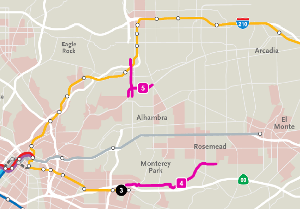
First/Riggin/Portrero Grande Bikeway, Monterey Park
This roughly 5.3-mile project project will cross east-west through unincorporated South San Gabriel, Cities of Monterey Park, Montebello, and Rosemead.
The project will connect to existing Riggin Street bicycle lane (0.5 miles) and sharrows (0.5 miles), and connect to future bike lanes on First Street in East Los Angeles as part of the Metro Gold Line Eastside Access Phase II project.
In Metro’s Active Transportation Corridors Project Profiles report, Riggin Street is proposed to include bike lanes from Atlantic and Garfield (including upgrading some areas that currently have sharrows.) Portero Grande Drive is proposed to include bike lanes.
Huntington Drive and Fremont Avenue, South Pasadena
This project is broken up into two sections:
- North Fremont Avenue between Alhambra Road and Columbia Street (1.8 miles), and
- Huntington Drive between Alhambra Road and Atlantic Boulevard (1.5 miles)
The city’s bike master plan has designated a bike lane for Huntington Drive and a bike route for North Fremont Avenue.
The project is proposed to eliminate existing and potential conflict areas by upgrading ADA paths of travel, implementing bike improvements approved in the bike master plan, improving intersection functionality, and providing a safe transition between corridors.
Both projects are still in the conceptual phase will most likely require more planning and community engagement efforts, said Metro spokesperson Dave Sotero.
SBLA San Gabriel Valley coverage, including this article and SGV Connect, is supported by Foothill Transit, offering car-free travel throughout the San Gabriel Valley with connections to the new Gold Line Stations across the Foothills and Commuter Express lines traveling into the heart of downtown L.A. To plan your trip, visit Foothill Transit. “Foothill Transit. Going Good Places.”
Sign-up for our SGV Connect Newsletter, coming to your inbox on Fridays.

Read More:
Streetsblog has migrated to a new comment system. New commenters can register directly in the comments section of any article. Returning commenters: your previous comments and display name have been preserved, but you'll need to reclaim your account by clicking "Forgot your password?" on the sign-in form, entering your email, and following the verification link to set a new password — this is required because passwords could not be carried over during the migration. For questions, contact tips@streetsblog.org.