L.A. County Seeks Public Input on New L.A. River Plan
At a press event today, L.A. County leaders unveiled their new plan for the Los Angeles River. The county is now accepting comments on Draft L.A. River Master Plan.
The 2021 plan is an update to the county’s initial L.A. River Master Plan approved in 1996. That plan led to the county opening up fenced-off portions of the river, fostering new parks, walk and bike paths, and greater community access. Cities along the river – including Los Angeles, Long Beach, and Glendale – stepped up efforts to revitalize areas along the river.
In 2016, County Supervisor Hilda Solis shepherded the county’s campaign to update its aging river plan. That effort is coming to a conclusion after years of community meetings and other public processes. The new plan was developed by the County Department of Public Works in collaboration with architect Frank Gehry and landscape architect Laurie Olin.
The county river plan is trying to strike difficult delicate balance on many issues. At this morning’s press event Supervisor Sheila Kuehl mentioned the balance between an overall “coherent holistic” vision and a “great deal of local community control.” Solis touched on the need for river revitalization to serve park-poor low-income communities of color, while addressing issues of gentrification and homelessness. Historically plans for the river have struggled to find the space to address a broad range of needs in communities it flows through; these needs include parks – with both active and passive recreation – housing, schools, and much more.
The plan ends up trying to address all of these issues within a fairly limited jurisdictional corridor. The river system is a tangled jurisdictional mess. County Public Works (acting as the County Flood Control District) controls the river channel structures, but the adjacent, and in cases underlying, land is the jurisdiction of various cities. The county’s jurisdiction is constrained by the federal U.S. Army Corps of Engineers, which mandates flood damage minimization standards. The county has little control over the numerous freeways and several rail lines that constrain the river. Many of the complex issues that impact the river – from watershed rainwater runoff to homelessness to gentrification – are largely situated outside the waterway corridor itself.
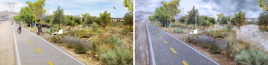
The plan includes a tool kit with for six different strategies for river revitalization: trails and access gateways, channel modifications, crossings and platforms, diversions, floodplain reclamation, and off-channel land assets.
The cross-river platforms have drawn criticism.
In reporting on the plan, the L.A. Times noted that environmental and environmental justice groups have criticized the “ecological harm” that could be done by proposed platform structures encasing the waterway. While advocates have been supportive of new walk/bike bridges that connect communities divided by the river, platforms over the river – already happening on river tributaries in Glendale, San Gabriel, and Rosemead – have served to erase the river, to hide it from communities.
At today’s press event, Gehry dismissed naturalized visions for the river, stating that “beautiful and fish” environmental restoration is not feasible – and that “beautiful romantic greenery would displace people.”
Gehry, in emphasizing bringing improvements to underserved communities, has focused on a platform proposal at the confluence of the L.A. River and the Rio Hondo in the cities of South Gate and Lynwood. The design would include lids over the two waterways, and building a new cultural center on the County maintenance yard on the east side of the river at Imperial Highway. (See map at L.A. Times.) Solis has pressed for an additional river confluence station to be added to Metro’s West Santa Ana Branch rail plans; that station, which would serve the proposed cultural center, is currently being studied by Metro.
The full draft plan, available at this county webpage, includes:
- a 100-mile (both sides of the ~50-mile river) trail system for walking and bicycling
- 78 significant projects – 56 from previously published plans and 22 newly-proposed project sites
- strategies for addressing adverse impacts to housing affordability and people experiencing homelessness
- strategies for enhancing water quality, water supply, and water safety
- financing strategies for constructing and maintaining river projects
The county is seeking public comment on the plan – use the county webpage input form – for the next 60 days. The County Board of Supervisors is expected to approve the final plan this summer.
Correction 1/13/2021 5:30 p.m.: This had erroneously stated that the county released a draft Environmental Impact Report (DEIR) for the L.A. River Master Plan. A county representative clarified that the environmental document has not been released – only the plan. The county states that there will be a forthcoming CEQA document (Programmatic EIR, PEIR) that will have its own public comment period.

Read More:
Streetsblog has migrated to a new comment system. New commenters can register directly in the comments section of any article. Returning commenters: your previous comments and display name have been preserved, but you'll need to reclaim your account by clicking "Forgot your password?" on the sign-in form, entering your email, and following the verification link to set a new password — this is required because passwords could not be carried over during the migration. For questions, contact tips@streetsblog.org.