
While Adding Bikeway Mileage, L.A. City Missing Some Opportunities
Earlier this week I reported on the city of Los Angeles’ recently implemented bikeway mileage. That post notes that bikeway mileage installation rose during fiscal year 2019-20, with a lot of new and upgraded bikeways on streets newly resurfaced by Streets L.A.
While I applaud the new bikeways – and smooth repaved streets – it does feel like the city missed some opportunities. Personally, I like that the city is stepping up bikeway installation somewhat, so the missed opportunities below are perhaps nitpicky. But I noticed many of these, so I felt compelled to get them off my chest here.
The L.A. City Department of Transportation (LADOT) has made some efforts to prioritize projects based on where safety improvements are needed, focusing on the Vision Zero High Injury Network. But, by and large, bikeway implementation remains more opportunistic than strategic. LADOT still tends to put bikeways where they fit easily, rather than where they are most needed. This tends to mean more bike lanes in more suburban parts of the city – especially the San Fernando Valley – and fewer bike lanes in central Los Angeles. It also results in a scattered, unconnected bikeway network with many, many gaps.
A decade ago, LADOT often took what I have called a throw-the-baby-out-with-the-bathwater approach, where sometimes a short pinch-point bottleneck was used as an excuse to omit miles and miles of bike facility. Until advocates pushed to correct it, the city had omitted miles of Reseda Boulevard from early drafts of the “2010” bike plan, because they couldn’t figure out how to add bike lanes on one narrow two-block stretch . (In 2011, the city solved this by removing on-street parking to add the bike lane on those two blocks.) Under Mayor Antonio Villaraigosa’s push for miles of new bikeways, LADOT improved its approach, adding bike lanes to some corridors previously deemed unfeasible. One example of this was the 2.7 miles of bike lanes added to Burbank Boulevard from Radford Avenue to Hazeltine Avenue in North Hollywood. There is a two-block bottleneck (from Woodman Avenue to Ventura Canyon Avenue) where the street is too narrow to easily squeeze in bike lanes. In 2012, LADOT added bike lanes for the 2.7-mile stretch, but sensibly dropped the facility down to sharrows for just those two narrow blocks.
With great repaving comes great opportunities. In Fiscal Year 2020-21, LADOT took advantage of a lot of repaving opportunities, but also missed several chances to make bicycling safer and easier. But many many repaved streets didn’t get the bike lanes the could have had.
Wide Streets Repaved – With Bike Lanes Omitted
LADOT is still allowing some narrow pinch points to shorten facilities. Even on some recently repaved streets, LADOT installed bike lanes for shorter extents than appears feasible.
The most prominent examples of this recently are on 5th and 6th Streets in downtown Los Angeles. Fifth and Sixth received new left-side one-way protected bike lanes in August as part of a project that included resurfacing and new bus lanes. Unfortunately, the bike lanes are only about half as long as the bus lanes, because a narrow two-block stretch between Hill and Spring streets would have required removing some on-street parking to fit in a bike lane.
But because of those two narrow blocks, the city omitted five blocks of bike lanes. The narrow parts of 5th and 6th usually have fairly calm traffic; many cyclists can share lanes there with cars, so a short stretch of sharrows (like on Burbank Blvd) probably would have been appropriate, with the bike lane resuming where the streets widen out for the three blocks between Hill and Figueroa Street.
Instead of extending the bike lane west of Spring Street, the city installed signs to tell cyclists they should share the bus lane. This is hardly comfortable for less intrepid cyclists, and could end up slowing bus speeds. Had the city extended the left-side bike lanes instead, the new bus lanes could have been more effective.
Somewhat similarly, the city repaved and upgraded Olive Street’s bike lane – from right-side buffered to left-side protected. Unfortunately, the upgrade only took place where there was already a bike lane south of 7th Street, while the repaving extended a couple blocks north of there. To LADOT’s credit, they did extend the Grand Avenue bike lane a couple blocks when that street was repaved. Grand is the matching couplet to Olive. Had L.A. City been more committed to Vision Zero, combating climate change, encouraging cycling, etc. it could have taken advantage of the repaving to also extend the Olive bike lane.
In Sun Valley, the city repaved a stretch of roadway where Vineland Avenue essentially becomes Sunland Boulevard. At this somewhat complicated junction, the city extended the northbound bike lane on Sunland Boulevard about 500 feet (nearly to San Fernando Road) but omitted the southbound bike lane.
The reason for this appears to be two on-street parking spaces at 8111-8113 Sunland – two businesses with a parking lot in back. It’s not trivial to remove parking, but it is nonetheless disappointing that in this case, LADOT has omitted 600+ feet of bike lane to preserve about 35 feet of parking.
In FY20-21, the city extended the Strathern Street bike lanes in Sun Valley along a newly resurfaced quarter mile from Laurel Canyon Boulevard to Radford Avenue. In the field, I observed that there was space to extend the bike lanes east of Radford, which had also been resurfaced. Online I could see that the stretch eastward had been resurfaced the prior year – so this was another earlier missed opportunity to extend the bikeway network.
Dropping Bike Lanes Well Before Intersections
LADOT often cuts facilities short are bike lanes that end before the end of the block. Some of this is arguably necessary, as the approach to an intersection may have various turn lanes – but studies show that intersections are where most car/bike crashes occur (75 percent according to one study). In midblock, the bikeway design is relatively easy; approaching the intersection takes just a bit more attention and thought. Drivers and cyclists may be merging and/or turning; engineers may need to spend time in the field to observe how cyclists and drivers are using the site. To me, it feels like LADOT often throws up its hands and says “skip it – just end the bike lanes ahead of that complicated area.”
The new westbound Riverside Drive ends a full block (300 feet) before the T-intersection with Van Nuys Boulevard. There is plenty of width at the intersection. The right-turn lane is about twenty feet wide, a width that allows drivers to take the turn at higher speeds, endangering all road users. Given the T-intersection, all cyclists and drivers will turn, so it doesn’t make sense to just extend the bike lane along the curb. Ideally LADOT could provide two lanes for cyclists – one for turning left and one for turning right.
Forest Lawn Drive was repaved and received a new buffered bike lane. But the westbound bike lane now ends 600 feet before Barham Boulevard. Up until last year, it ended about 450 feet shy of Barham. In the scheme of things, 150 feet is not that important, but it is disappointing that even when the city upgrades bikeways, they sometimes shorten them.
Squeezing Bike Lanes Onto Hilly Streets
One treatment that would allow LADOT to add a few more bike lanes is an asymmetric treatment on hills: a bike lane going uphill, and sharrows going downhill. This isn’t ideal (it doesn’t serve beginner cyclists, and speeding drivers can tailgate fast-moving downhill cyclists), but it does allow for some spatial separation when cyclists are moving fairly slow uphill. The treatment is used in many cities, including San Francisco. For some reason, Los Angeles doesn’t use it.
In Porter Ranch, Tampa Avenue narrows slightly south of Superior Street. The city repaved this part of Tampa, adding bike lanes north of Superior, but omitted the bike lanes below it. Cyclists going downhill can more or less share a lane there – hence sharrows are perhaps appropriate. Bicycling slowly uphill next to speeding car traffic is uncomfortable, and could benefit from separation.
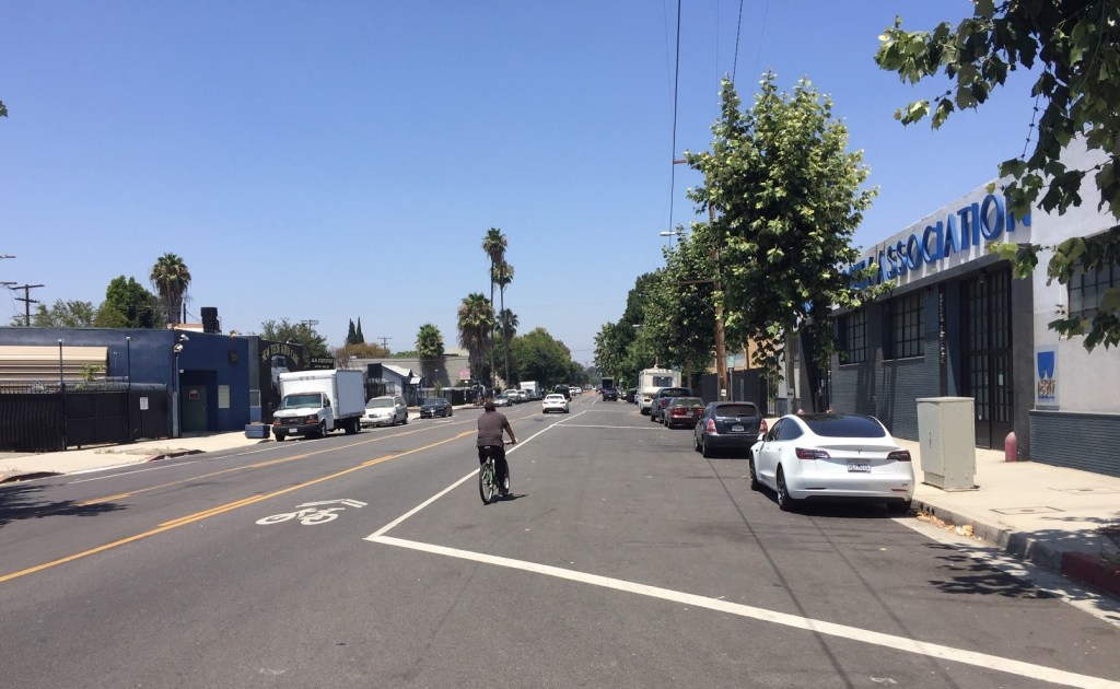
Adding Another Car Lane, Calling It New Bikeway Mileage
In July, I wrote a short piece about the sharrows that were added to Tujunga Avenue in North Hollywood (photo at top.) I did cherry-pick the widest section of a street where the width varies quite a bit (due to wrongheaded city street widening practices), and varying width doesn’t make for simple neat lane designs. After I wrote that piece, I found out that sharrows weren’t the only thing added to that stretch of Tujunga Ave. Prior to mid-2019, Google street view shows it was a two-lane street with two fairly wide lanes capable of being shared by cyclists and drivers. Last September, the city added a ten-plus-foot-wide center turn lane, pushing the drivers and cyclists into the same slot.
The new center turn lane indicates that there was enough space for bike lanes on Tujunga Avenue, but the city prioritized car space instead. Then they counted those sharrows toward the total bikeway mileage for the year, though the street had been made worse for cycling.

Streetsblog has migrated to a new comment system. New commenters can register directly in the comments section of any article. Returning commenters: your previous comments and display name have been preserved, but you'll need to reclaim your account by clicking "Forgot your password?" on the sign-in form, entering your email, and following the verification link to set a new password — this is required because passwords could not be carried over during the migration. For questions, contact tips@streetsblog.org.


