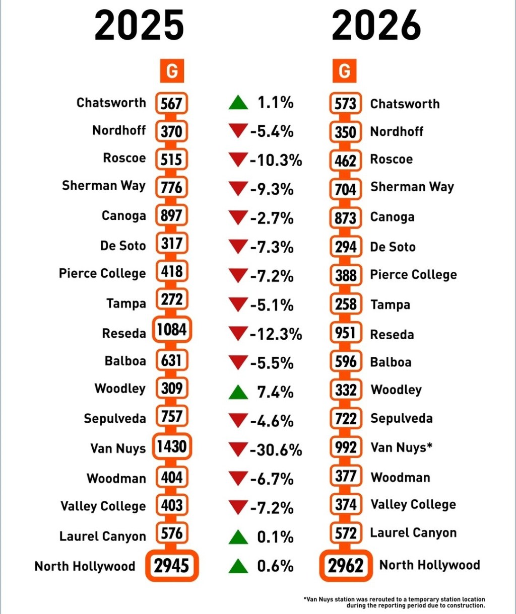
Metro Prohibits Bicycling/Walking On First Street In Little Tokyo
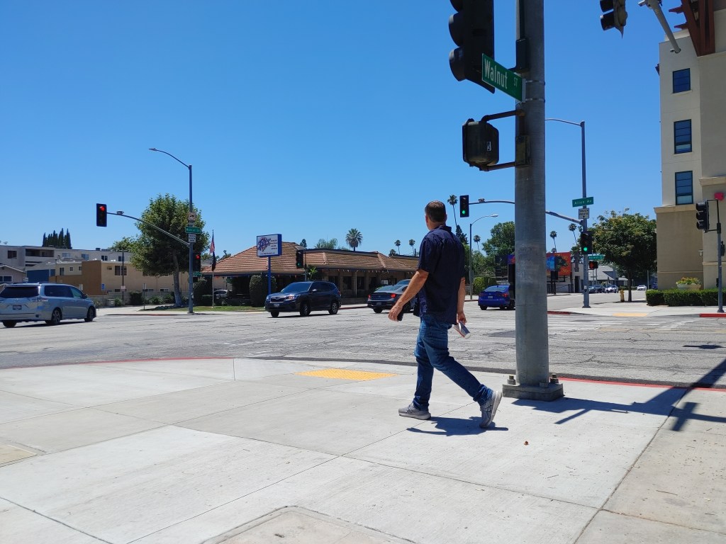
Metro recently announced that bicycling is prohibited on westbound First Street between Vignes Street and Central Avenue in downtown Los Angeles’ Little Tokyo. Metro has also prohibited walking on the sidewalk on the north side of First Street.
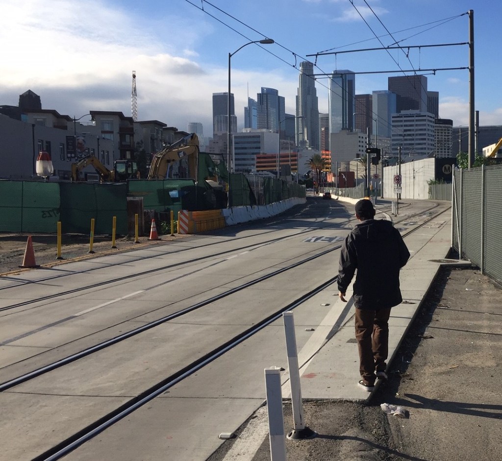
The prohibitions are due to multi-year Metro Regional Connector subway construction underway. Right now, on this stretch of westbound First Street, cyclists cross two sets of temporary Gold Line train tracks. These tracks are close to parallel with the cyclist trajectory, hence there is some danger of cyclists falling due to bike wheels getting caught in the tracks. To be safe, cyclists must not travel in a straight line, but instead zigzag to cross at an angle near perpendicular to the tracks.
Last week, Streetsblog became aware of the bike prohibition from a mention at Biking in L.A. which linked to a Metro notice dated December 5, 2018. Metro’s website states that “westbound 1st St is closed at Vignes St to all bicyclists through 2021” and “to avoid citations” cyclists must use the detour on Vignes Street, 2nd Street, and Central Avenue.
Metro spokesperson Rick Jager reported that the bicycle detour has been in place since 2017, and that “Metro is aware of a few accidents at this location by cyclists.” Jager further states that “Cyclists can still travel on First St by using the southern sidewalk of the corridor.”
Metro has posted two small, easy-to-miss orange bike detour sign at Vignes and First. Can you spot them in Google street view?
The agency also posted an uneven pavement pictograph sign showing a crashing cyclist, on First west of Vignes.
The prohibition/detour closes westbound First Street to cyclists and pedestrians, while keeping two lanes open for drivers.
The legality of detouring cyclists while keeping the street open for motorists is questionable under California vehicle code law (section 21200) which states that “A person riding a bicycle … upon a highway has all the rights … applicable to the driver of a vehicle.”
If used, Metro’s bike detour changes a cyclist’s 1,600-foot straight ride to a 2,700-foot ride with two left and two right turns. The detour includes three signals and two stop signs.
Would motorists stand for such an indirect detour?
Aside from being much less direct and perhaps not even legal, it is questionable whether the bike detour is safer than crossing the tracks.
Metro expects cyclists to turn left from First Street onto Vignes in a shared lane where drivers (going downhill on the bridge ramp) can go straight or left in the same lane. This makes it likely that turning cyclists waiting in the intersection could be run over by fast moving drivers (likely distracted) rushing straight ahead. Bicyclists are expected to turn right from Vignes onto 2nd Street where drivers do not have a stop. Cyclists must also turn left at the T-intersection at Central and First, where they encounter a conflict with right turning cars.
Experienced cyclists can and do navigate these traffic situations all the time, but then again, experienced cyclists also know how to cross train tracks safely. These conflicts and exposed turns can be daunting for inexperienced cyclists. Other than tiny orange bike detour signs, Metro has not done anything to make the detour safe, easy, or comfortable for cyclists. If cyclists are to be restricted from westbound First Street, why not take measures to make them truly safe on Second Street? Perhaps restrict motorists there? Why not add temporary westbound bike lanes on the detour, or bicycle boulevard treatments?
Little Tokyo is one of L.A.’s most walkable neighborhoods. It is tourist-rich and population-dense. Metro’s walking and bicycling prohibitions are a block from a Metro Gold Line station and a Metro Bike Share station. Metro (perhaps with LADOT’s approval?) has chosen to allocate space for car-throughput over safety, walkability, and bikeability – even in central downtown locations.
Why, especially in this setting, prohibit bicycling and walking while giving drivers two lanes?
The detour represents a counterproductive ostrich-head-in-the-sand approach that advocates have criticized elsewhere – including Playa Del Rey and L.A. City bicyclist lawsuits. Governmental players identify a situation that is unsafe for pedestrians and/or cyclists. Then instead of fixing it – actually making the location safer – they inexplicably decide that cyclists/pedestrians just won’t go there. This approach does not work. It is not working in Little Tokyo right now. Every day, pedestrians and cyclists continue to travel on this portion of First Street.
Cyclists don’t use Metro’s ridiculous detour.
Neither do pedestrians.
Metro apparently just looks the other way, and hopes injury lawsuits don’t pile up.
Even during multi-year construction, this represents a bad precedent. Metro needs to make streets safe for walking and bicycling.
Making streets safe is not rocket science. It is not even expensive. There are proven ways to use pavement markings to make sure bicyclists cross near-perpendicular to the tracks. Metro has done this where cyclists cross the Expo Line tracks at Gramercy Place. There is an instructive Seattle example from Seattle shown in this short Streetfilm documentary. San Francisco uses similar markings.
Metro needs to fix this unsafe situation.
Two Updates added 10 January, 2019:
The article is correct and remains unchanged, but Metro actually posted five signs directing cyclists to use the detour. SBLA missed three signs posted on the First Street Bridge. Based on Google street view, it appears that one additional sign was added since April 2018.
Following a elderly Latino bicyclist across the tracks there yesterday, this SBLA editor observed a different way to cross, that makes it appear there could be a way to make First Street safer without necessarily removing a through lane for cars (which may be difficult politically and would probably still be a little safer than what follows.)
Many cyclists that cross the tracks there are staying in the right lane and zigzagging within the lane, so as to cross the tracks at a safe angle. The cyclist observed yesterday got out of the lane, cutting right into the rail right-of-way before crossing the tracks. This smart maneuver makes for no conflicts with cars while crossing tracks. It does make for a potential conflict point (where cyclists must be cautious) when re-entering the roadway. Below are a photo and map showing this safe way to cross, which Metro could study further and potentially apply pavement markings to direct cyclists to use. See also this video.

Read More:
Streetsblog has migrated to a new comment system. New commenters can register directly in the comments section of any article. Returning commenters: your previous comments and display name have been preserved, but you'll need to reclaim your account by clicking "Forgot your password?" on the sign-in form, entering your email, and following the verification link to set a new password — this is required because passwords could not be carried over during the migration. For questions, contact tips@streetsblog.org.