Interactive Zoning Map of Boyle Heights Community Plan Includes Look at “Innovative District”
City Planning posted the interactive map of Boyle Heights this past weekend to highlight zoning.
Last Friday, we posted a preview of the draft community plan for Boyle Heights ahead of the Department of City Planning's open house.
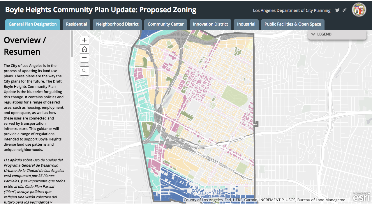
After the open house this weekend, the interactive zoning map was posted on the website for the plan (above, link to actual interactive map is here).
According to City Planning, the interactive map breaks down residential, industrial, neighborhood, community center, and public space districts and "illustrates proposed changes addressing land-use mix, height, massing, and [the] feel of the buildings along the street. These detailed zoning and land-use recommendations were developed based on the City’s goals for [the] economy, mobility, health, and sustainability, and were informed through public input over the past several years." Together with the draft plan, it provides a blueprint for how the community will grow and change over time.
The ability to isolate specific zoning changes along the river and see the shift toward lighter industry is a reminder that the city has yet to launch a meaningful dialogue with Boyle Heights about what it means to create an "Innovation District" on its western edge.
Things have gone very differently in the push to build the capacity for innovation downtown.
Last summer, in collaboration with the Brookings Institution and Project for Public Spaces, the Downtown Center Business Improvement District (BID) launched Innovate DTLA - an effort to promote downtown L.A. as a hub of creativity and innovation for a diverse set of sectors energized by a vibrant population of residents and workers.
They may have been talking about the west side of the river during that launch, but the discussion was instructive all the same. Namely, that the most desirable and sustainable innovation districts are those that manage to create a nexus between innovation and place. And that to facilitate the networking and knowledge-sharing that drives innovation, the district must also be a destination - a place that attracts talented people whose purchasing power will help reshape and grow the area as the industries grow. [See presentation here.]
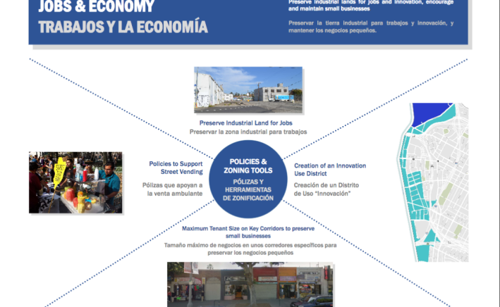
As noted in last Friday's preview article, the Boyle Heights Community Plan makes an effort to preserve space for smaller local businesses along commercial corridors and explicitly discusses the importance of street vending to the local community and culture. It even suggests ways in which new industries can partner with area schools and/or create programs to ensure that local residents are able to access jobs in the businesses that take root in the Innovation District.
But deeper conversations with stakeholders around what it means to create a thriving destination along the western edge of a historically disenfranchised community or what needs to happen so the community could benefit from and manage the growth of such an area have yet to be had. Considering that efforts to grow the Innovation District will get a boost from investments in the revitalization of the L.A. River (and the creation of pocket parks and promenades all along it) and the Sixth Street Viaduct Replacement project, park, and performing spaces, that seems like a tremendous oversight.
Stakeholders downtown have the capacity to put together a BID, engage new arrivals, and harness some of the change that comes with growth. The mom-and-pop businesses along key corridors like First or Cesar Chavez don't have that kind of capacity or power. And many of the organizations dedicated to providing services to a community in need have little extra bandwith to take on the city or the innovators it hopes to attract.
Hopefully, as the plan moves forward the city will consider the potential implications of creating a destination in a community that had been deliberately disadvantaged for so long and engage the residents accordingly.
For now, the next step in the plan approval process will be the release of the Draft Environmental Impact Report (DEIR), which examines the potential environmental impacts of the draft plan. Once the DEIR is released, city planning anticipates hosting another Open House as well as a Public Hearing, both to share any final plan or zoning changes and to give the public another opportunity to share their comments. From there, the DEIR goes before the City Planning Commission, the Planning and Land Use Committee (PLUM) of the City Council, and, finally, the City Council for approval.
Find information about the plan process as well as the draft plan itself at http://www.bhplan.org/.
Stay in touch
Sign up for our free newsletter
More from Streetsblog Los Angeles
No, L.A. City Does Not Always Add Required ADA Ramps During Resurfacing, But They Should
StreetsLA GM Keith Mozee "Any time we do street resurfacing, it is considered an alteration, which requires ADA ramps to be installed."

LAPD Was Crossing Against Red Light in Crash that Killed Pedestrian and Injured Six in Hollywood
The department says the officers had turned on their lights and sirens just before crossing, but won't say why they did so.