How Much of Your City Is Really Urban?
Editor’s note: Read to the end of this post for an important update on the Streetsblog Network.
Many places that get categorized as “suburbs” are actually pretty urban. They may not be located in a central city, but they are compact, walkable places. But the inverse is also true: Large portions of nearly every American city are pretty spread out and suburban in character.
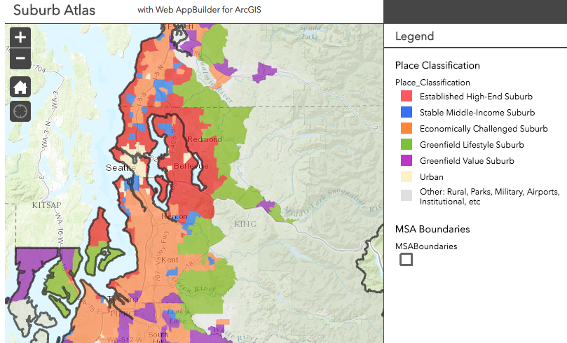
A new report from the Urban Land Institute [PDF] divides every metro area into a number of classifications based on density and other factors. You can click through ULI’s map and see whether they consider your neighborhood urban or suburban.
Frank Chiachiere at Seattle Transit Blog notes that ULI classifies almost all of Seattle as suburban, and he thinks that’s basically correct:
The report seeks to subdivide suburbia, using census tracts, into five categories — Established high-end, stable middle-income, economically challenged, greenfield lifestyle, and greenfield value — to reflect the diversity of communities that are often lumped together as “the suburbs.” The modern suburb, they argue, is a hodgepodge of very different housing and land-use types, a continuum that stretches from stately, tree-lined streetcar suburbs close to the center to the sprawling planned communities on the exurban fringe.
What’s interesting its that the report finds that there’s not much different between North Ballard and Bellevue: both are classified as “established, high-end” suburban communities. Seattleites might chafe at the comparison, but there’s something to it.
The only parts of Seattle that are classified as urban are downtown and the neighborhoods immediately adjacent (roughly the Seven Hills + parts of the North end). These urban neighborhoods count for less than half a percent of all the land in the metro area, while housing 9% of the population (and, perusing the methodology, it may be that even these neighborhoods qualified as urban not solely because of their density, which isn’t very high, but simply because of their proximity to the city center).
The rest of the map’s classifications seem more-or-less on point from my experience.
Elsewhere on the Network today: Greater Greater Washington urges federal civil service employees to stay through the Trump years and do their best to make government work well. Spacing looks at what the research says about the effectiveness of “slow down” road signs. And Transport Providence reports that the fight to tear down a local urban highway is lost, but advocates did win some concessions.
An important note about Streetsblog.net: On Monday, Streetsblog will be launching our first major site overhaul since 2008, including a fully mobile-responsive redesign that will look great on phones and other devices. As part of this restructuring, we are folding all the content on the Streetsblog.net domain into Streetsblog USA.
For readers, the major change will be that the Streetsblog.net domain will redirect to Streetsblog USA. No content will be lost. All Streetsblog Network content will be archived at Streetsblog USA, and old URLs will point to new locations at usa.streetsblog.org. The one permanent change is that we are shutting down the RSS feed for the Streetsblog Network, which had grown a little too large to be useful to most people. (It picks up content from nearly 500 sites.)
Going forward, this will be a minor transition. We will continue to keep tabs on sites around the country that write about streets and transportation issues, and will post a round-up like this one each weekday. If you have a site you want to put on our radar, you will still be able to do that.
We’re very excited about the redesign and giving our readers a better experience. Stay tuned.

Read More:
Streetsblog has migrated to a new comment system. New commenters can register directly in the comments section of any article. Returning commenters: your previous comments and display name have been preserved, but you'll need to reclaim your account by clicking "Forgot your password?" on the sign-in form, entering your email, and following the verification link to set a new password — this is required because passwords could not be carried over during the migration. For questions, contact tips@streetsblog.org.