The City of Los Angeles is moving plans to replace the Glendale Boulevard-Hyperion Avenue Complex of Bridges over the Los Angeles River near Hollywood and Atwater Village. You can read the full EIR, here.
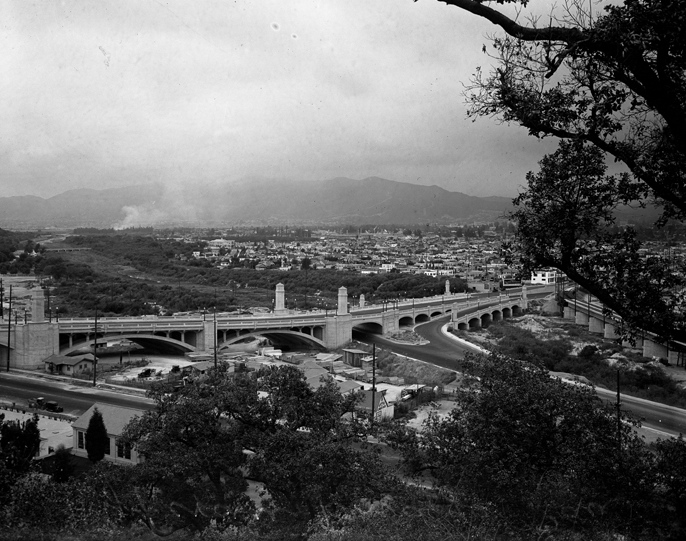
The Glendale-Hyperion Viaduct complex consists of the following structures: Hyperion Avenue Bridge over the Los Angeles River, Hyperion Avenue Bridge over Riverside Drive, Hyperion Avenue Bridge over I-5, Southbound Glendale Boulevard Bridge over the Los Angeles River, Northbound Glendale Boulevard Bridge over the Los Angeles River, and Waverly Drive Bridge.
Despite bike lanes on the bridge appearing in the 2010 Bicycle Plan approved by the city, the bridge contains no bike lanes and has less than standard width sidewalks. A public meeting will be held on the project tomorrow night, and the Los Angeles County Bicycle Coalition (LACBC) is urging cyclist and safety advocates to turn out.
"The existing viaduct is currently the greatest barrier for bicycle travel between Hollywood and Atwater Village," writes Eric Bruins with the LACBC.
"Hyperion is basically the flattest route across the LA River north of downtown, which is why it was identified in the L.A. Bicycle Plan for bike lanes, yet the project does absolutely nothing to accommodate bicyclists accessing the area from the west. There are some really great local improvements connecting the L.A. River to Atwater Village, including a new ramp and pedestrian bridge, but the project does not apply a complete streets approach to regional mobility, as required by both Caltrans policy and the City's bike plan."
The largest issue that cyclists have with the environmental documents isn't just that it dismisses bike lanes without doing any real analysis, but that it does so and then says that it's in accordance with the Bicycle Plan with no further explanation.
Adhering to the 2010 City of Los Angeles Bicycle Plan (refer to Section 2.4.2.1), the new shoulder on Glendale Boulevard can be used as a bicycle route. Though the proposed project will not include a bicycle lane on Hyperion Avenue, the project is consistent with the plan.
Normally, when a project plan is not in accordance with an existing Master Plan or Circulation element, the environmental documents will say that they are and explain how the plan will mitigate this shortcoming. Right now the city is denying the impact outright.
That could be grounds for a lawsuit.
That being said, city staff claim that the bridge redesign is a win for bicyclists. Via a spokesperson for Council Member Tom LaBonge, who along with Mitch O'Farrell represents the project area in the City Council, the Department of Public Works explains what those mitigation measures are.
1. Part of the project scope is to re-align the I-5 NB off-ramp at Glendale Blvd. By relocating the off-ramp away from the river (Environmental doc ref.: Figure 1-3B, Footprint Map), a space will be made available to construct a new bicycle access ramp to the existing LA River Bikeway on the downstream side of the bridges. (Environmental doc ref.: pg. 1-16, New Bike Path Access)
2. Glendale Blvd Bridges NB and SB both will be widened, which will accommodate a striped bike lane when LADOT has developed bike lanes on Glendale Blvd beyond the bridges in the future. (Env doc ref.: pg. 1-16, Traffic Lane Restriping: the 6-ft shoulder may be used for future bike lane)
While the improvements to the Glendale Bridges are encouraging, the lack of a bicycle lane promised on the Hyperion Avenue Bridge means that instead of a smooth flow between the communities of Glendale, Hollywood, Silver Lake and Atwater, the city will have a hodge-podge of half measures that don't get cyclists where they need to go in a safe and reasonable manner.
The Glendale-Hyperion Bridge is a concrete arch bridge viaduct in Atwater Village that spans the Los Angeles River and Interstate 5. The bridge spans 400 feet over the Atwater section of the Los Angeles River and has four mixed-use travel lanes. The improved bridge will also have four lanes.
Listening to staff at the DPW and with both O'Farrell and LaBonge's offices, one doesn't get the sense that they are indifferent to cyclists needs in the area, and that they believe the half-measures outlined above are enough. Neither this piece, nor the LACBC, see this as an issue where the city needs to be barraged with bad press.
However, as with so many things in life the first step can often be the hardest: admitting you have a problem. Cyclists can help them make that step by either attending tomorrow's meeting, or emailing Tami.Podesta@dot.ca.gov and let the person overseeing the environmental studies know there is a problem with the plan. The meeting will be from 6:00 – 8:00 p.m. at Friendship Auditorium, 3201 Riverside Drive. The LACBC has set up a Facebook event for it, which you can find here.