
Metro Responds to Missing Downtown Connector Bikeways: Agency Followed Undefined Plans, Prioritized Getting Drivers to Freeway
Metro didn't follow its own designs or city-approved CEQA-approved street standards - instead implementing not clearly defined changes that added car capacity - and omitted bike and walk facilities
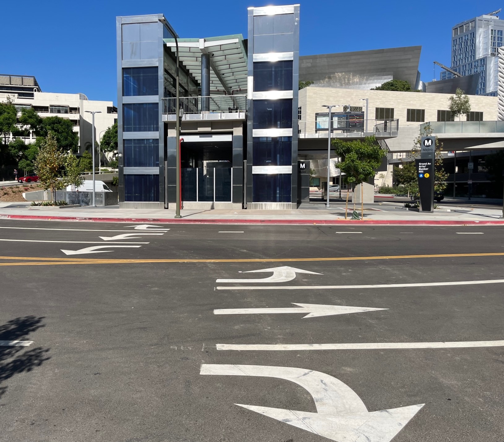
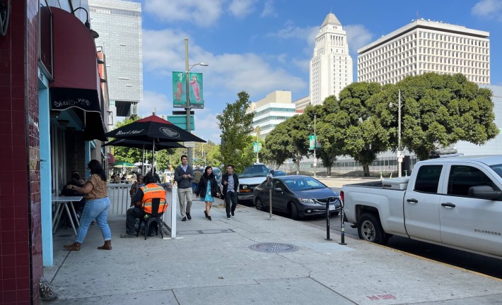
Metro’s new Grand Avenue Arts/Bunker Hill Station – photos by Joe Linton/Streetsblog
Streetsblog readers may recall that Metro left out and downgraded several first/last mile bike and walk connections to the new Regional Connector subway stations that opened recently in downtown Los Angeles. After safe streets advocates submitted a formal request to Metro fix the omissions, Metro CEO Stephanie Wiggins responded with a 4-page letter.
The upshot of Metro's letter: Metro won't fix anything now.
I critique Metro's letter below, but first some background.
At Grand and Broadway Stations, Metro ignored approved street specifications. At Little Tokyo Station, Metro radically pared back bike/walk facilities included in a federal TIGER grant.
Grand Avenue Arts/Bunker Hill Station Example
Metro's omissions at its Grand Avenue Station are pretty bald. They really bug me because, despite longstanding city approvals for bike lanes there, Metro did not include a single inch of space for cyclists to access the station.
Back in May 2009, the L.A. City Council approved the city's Downtown Street Standards. Some L.A. City plans are now seen as not legally binding (that's another story), but city street standards have always been legally binding (meaning lots of city-mandated spot-widening) until Metro ignored them building the Regional Connector.
For Flower Street between 1st and 3rd Streets, the 2009 street standards specify keeping the existing street width and the existing number of car lanes, while adding bike lanes.
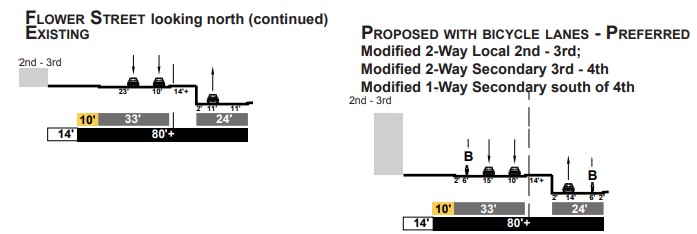
The way street standards work is that when any entity (generally a public agency or a developer) does significant construction along a street, the builder is required to implement the approved standard. Most of the time, this has meant widening roads - but not in downtown. The downtown standards deliberately ended nearly all road widenings in order to "to design for complete streets that are context sensitive and promote sustainable development," specifically calling for balancing car capacity against "pedestrian needs, public transit routes and stops, bicycle routes, historic districts."
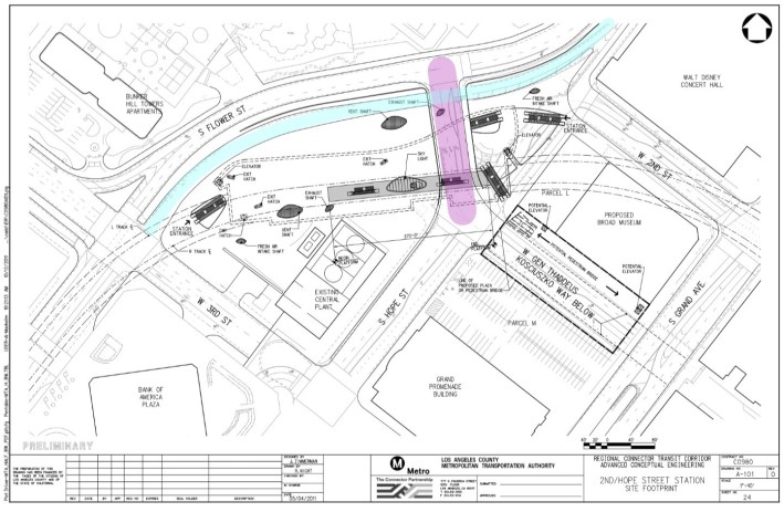
In April 2012, Metro approved the Regional Connector's environmental clearance documents (called an EIS/EIR - Environmental Impact Statement/Report). At the time, this was Metro's design for its Grand Avenue Station:
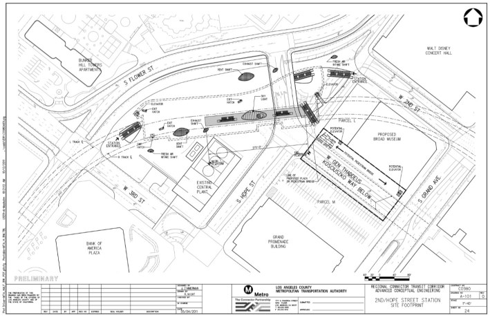
Connector construction broke ground in 2014. The project opened in June 2023.
Below is Metro's 2022 Final Street Reconfiguration Plan at the Grand Station, via this Metro presentation. This is close to, but not the exact final Metro lane striping. What Metro built is very different from the EIR/EIS design approved by Metro's board. Metro didn't close Hope Street, omitted a planned lower station portal, and widened station area streets to enhance car capacity.
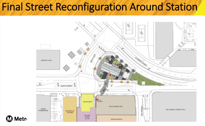
Let's compare those images. Here are highlighted versions of the above maps, showing two streets where drivers got unapproved "betterments" (CEO Wiggins terminology).
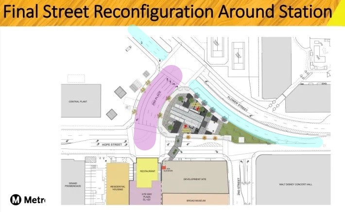
At Grand Station, Metro installed the following capacity expansion for drivers:
- Flower Street (blue - lower Flower is sometimes labeled Hope Street): Below Kosciuszko (purple), Metro added a new right turn pocket, widening that part of Flower from 24 feet to 36 feet. At that spot the city's approved plan shows one bike lane and one car lane. What Metro built instead was three car lanes. North of Kosciuszko, Metro did not widen Flower, but added a second car lane (taking up the space where the street standards specified a bike lane would go.)
- Kosciuszko Way (purple): Metro widened Kosciuszko from 4 lanes to 6 lanes (from ~50 feet wide to 72 feet wide) immediately in front of the station..
These widenings and car lane additions (which cost Metro millions of dollars) were not in the city's 2009 approved street standards, nor in Metro's 2012 EIR/EIS.
At Grand Station, Metro left out bike lanes, crosswalks, and a lower station entrance, but still managed to add roadway capacity for drivers. Metro left in place pedestrian-hostile infrastructure, including already over-wide downtown roads and a dangerous slip lane at 3rd and Flower.
Cramming more cars, and more roadway up against subway stations is a big step in the wrong direction, and a missed opportunity. Metro stations, especially downtown, should be among the most walkable places in the region. For pedestrian safety, Metro and the city Transportation Department (LADOT) should be narrowing streets - not just because the city approved some narrowing in its 2009 street standards but because of how Angelenos get to Metro stations: nearly all Metro riders arrive on foot. In 2023, Metro and the city should go further than what was envisioned way back in 2009; station areas should be saturated with walk and bike features, like pedestrian plazas (street closures), scramble diagonal crossings, protected bike lanes, bike-share stations, and more.
But instead of embracing this walkable, bikeable future, Metro and LADOT reached back into a mid-20th Century vision: surround Grand Station with dangerous, widened roadways.
Similar Metro widening took place at other Connector stations; Metro widened parts of 1st Street, 2nd Street, Alameda Street, and Temple Street.
Metro Explains - Parsing CEO Wiggins' Response Letter
Metro's response letter asserts that generally bikeways were omitted because they are not light rail infrastructure. "Funding rules from the Federal Transit Administration (FTA) for the Project do not allow for reimbursement for the construction of betterments," Wiggins wrote. "The FTA defines betterments as those elements that do not directly contribute to the delivery of the transit guideway and related systems. Funds are only to be expended on light rail infrastructure items and on the replacement of street elements, in-kind, disturbed during construction."
There's a double standard here. Metro widened numerous streets, added new car lanes, new turn pockets - all for drivers. Those are neither "light rail infrastructure" nor "in-kind replacement." Metro spent millions on roadway capacity expansion for drivers (to the detriment of the safety of pedestrians, transit riders, and cyclists). But when it came to relatively inexpensive basic bike and walk facilities, Metro says its hands were tied by the FTA. Bike lanes, crosswalks, and walkways were a betterment too far.
Specifically at Grand Station, Wiggins asserted that driver betterments were part of "significant traffic pattern changes" from "LADOT and other City departments." The letter noted that these changes were neither "clearly defined" nor "developed":
Flower Street from 1st Street to 3rd Street – LADOT and other City departments are planning significant traffic pattern changes to Flower Street, including changing to bidirectional traffic through downtown. The installation of bike lanes will be addressed as the Flower Street engineering designs are developed and the associated vehicle lanes and signal alignments are more clearly defined. Bikeway profile grade and sight distance issues north of 3rd Street will also be addressed.
This is astonishing. Metro is admitting is didn't follow council-approved CEQA- (California Environmental Quality Act) approved street standards, and instead installed unapproved, unvetted, unpublished "changes." It's like a developer erecting a ten-story building in a five-story zone, because the developer thought that zoning changes were maybe going to be approved in the future.
Where the L.A. City Council specified that lower Flower Street was to be 24 feet wide with one traffic lane and one bike lane, Metro and LADOT decided to overrule the city council and build it 36 feet wide with three traffic lanes and no bike lane.
Engineers aren't allowed to set policy like this. Staff can't just overrule council-approved policies, making up street widths on the fly. Metro and LADOT can't just imagine a different no-bikes future scenario, then use that to bypass the current approved law. But - whether out of unintended negligence or assuming that nobody would notice - Metro did that here, adding more car capacity, contrary to approved plans.
What's odd is that, when this error was presented to Metro, Wiggins seems okay with it. Her letter admits the agency followed an unapproved plan as if that's just what Metro does.
As a longtime bike advocate, I find this infuriating. Advocates pushed and pushed to end harmful street widening, and succeeded in 2009 in transit-rich, pedestrian-rich, cyclist-rich downtown. Then during a once-in-a-lifetime $2 billion public works project, Metro tossed aside the approved street standards in favor of unapproved car capacity.
Wiggins' letter predicts that the bikeways "will be addressed" at some point in the future, but these bikeways were already addressed and already decided in 2009. Why wait? Why not right now? It's disingenuous (and perhaps illegal) to ignore Metro's approved station plan and the city's approved street plan in favor of something that may or may not be approved in the future.
Further on, the Metro letter justifies omitting bike lane protection in the name of prioritizing drivers getting to the freeway:
Bike lanes along the 1st Street Bridge over the LA River – Although a dedicated eastbound lane was installed, the existing bridge deck is not currently wide enough to make this a protected lane without removing a critical turn and/or thru-traffic lane. Given this important connection to the 101 freeway, LADOT and Council District 14 determined that the current configuration is the most prudent at this time.
In population-dense, transit-frequent downtown L.A., a block away from Pico Aliso Metro Station, Metro and LADOT openly admit that a "given" is prioritizing car drivers headed to the freeway.
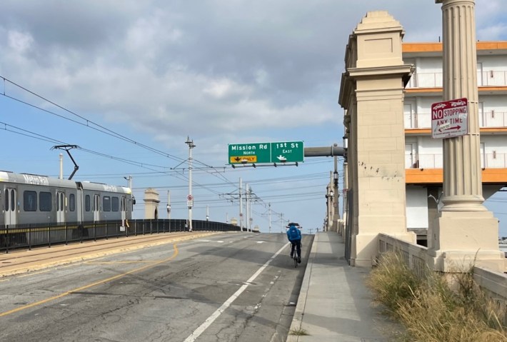
What's especially dismal is that the eastbound bikeway protection currently drops exactly where it is most needed: where the bike lane goes uphill, and cyclists are traveling slower than motorized traffic.
This abrupt drop in protection there isn't even necessary, as the left-turn pocket (onto Mission Street) is nearly a third of a mile long. It's more important to Metro and LADOT to have capacity for a hundred drivers to queue up for the 101 freeway than it is for Metro and LADOT to protect the lives of cyclists.
(And, this gets wonky/technical, but even the "bridge deck not wide enough" assertion is not true. Metro and LADOT striped 11- and 12-foot wide car lanes there, next to a 4-foot wide unprotected bike lane. If they, like the city does in much of downtown, minimized these lane widths to 10- and/or 10.5-feet, then the protected bike lane would fit. Narrowing lanes there would slightly slow down drivers - which should be something Metro and LADOT would want near downtown transit stations.)
Regarding Metro prioritizing freeway drivers on First Street, Metro states that this was determined by LADOT and Council District 14. The letter doesn't state which scandal-plagued City Councilmember they're blaming. CD14 was represented by José Huizar when Connector and TIGER plans were approved. Since 2020, CD14 is represented by Kevin de León.
In 2014 Metro, LADOT and CD14 proudly announced TIGER bikeway connections. In 2016 [staff report, map showing "travel lane removal"] and in 2021 [staff report] the Metro board approved project work that included the protected bike lanes.
So, at a minimum, this is another double standard. When advocates push Metro for bike lanes, Metro responds that it's too late, "the scope is frozen" (see below). But Metro is okay with, years into a project, removing bikeway features from a project scope - with little to no process or notice.
There's more not to like in Wiggins' letter:
- The letter implies that the city's bike lane plans came after Metro construction plans. She wrote "Metro’s FLM [First-Last Mile] Program did not exist when the Project was issued for construction bidding in 2013. The scope of the construction work was completed and frozen at the time of bidding and did not include the implementation of the City’s downtown-wide bike lane plans." But the city council approved Downtown Street Standards (which include bike lanes on several Regional Connector streets) in 2009, well ahead of 2013 construction bids.
- The letter asserts that "Sidewalk widths along this block [2nd Street at Broadway Station] are currently substandard." But they're not. The 2009 Street Standards largely codified existing roadway and sidewalk width. Metro appears to be referencing some generic sidewalk standard, not the standard that applies to 2nd at Broadway Station. In front of the station, Metro widened the 2nd Street roadway (contrary to the city-approved standards), so in effect the letter is asserting something along the lines of "Metro widened the 2nd Street roadway because of substandard sidewalks."
- Metro asserts several streets do not have sufficient space to add TIGER-specified bike facilities: 1st Street, Central Avenue, Judge John Aiso Street, Los Angeles Street, and San Pedro Street. But all these streets were chosen for the TIGER grant because they do have sufficient space for bikeways. For what it's worth, the Aiso/San Pedro bikeway is doubly-funded as LADOT also included that stretch in the recently awarded $38 million state grant for its Skid Row Connectivity and Safety Project.
- Wiggins' letter implies that Metro omitted bikeway protection on First Street in order to keep to al fresco dining, but the protected block in the TIGER scope (Los Angeles Street to San Pedro Street) has no in-street al fresco dining. Moving parked cars further from the curb would improve sidewalk dining there.
- Metro's letter claims that there is bollard-protection on the Ramirez Street and Center Street bike lanes - located adjacent to Metro Gateway Plaza headquarters. The letter states: "Ramirez Street/Center Street between Commercial Street and Vignes Street – Dedicated bike lanes exist here are partially buffered in some locations with bollards." This is wrong (factually and grammatically). Today there are no bollards on Ramirez or Center. Metro's TIGER grant scope included protected bike lanes on Ramirez and Center; Metro instead added unprotected lanes without bollards.
- The letter uses some awkward bike terminology that cyclists and transportation professionals rarely use. It repeatedly references "dedicated bike lanes" and, once, "full dedicated bike lanes." These phrases aren't unheard of, but they're sort of puffed-up ways to say "bike lanes." (Are there non-dedicated bike lanes?) The letter also refers to "shared bike lanes" (what's that?) and confusingly even "Shared westbound vehicle and bike lanes" on 2nd Street (which I would describe as having an eastbound bike lane and westbound sharrows).
- The letter misspells the name of Judge John Aiso Street, spelling it as "Aliso" Street.
The falsehoods, errors, and overall tone of the letter - echoed in the bike-unfriendly conditions on the ground - seem to indicate that Metro is fine with deliberately prioritizing adding more car capacity to roads around its stations.
Metro, with an $8 billion annual budget, doesn't appear to have a staff person conversant in bike planning, or concerned enough about bike and walk issues to get the facts right when drafting a response letter that's going to a bunch of bike organizations.
In the letter, Metro does not admit - much less commit to fixing - any of its errors, which seems to indicate that the agency can't be bothered to take low-cost steps toward assuring Metro's own riders are safe when they arrive by bike or foot. And if Metro can't prioritize people on foot or bike downtown, even with city-council-approved street specifications, what should Metro riders expect at stations along future Metro lines?
Postscript - Advocates Responded to Metro Today
As I was editing this post, livability advocates submitted their response letter to Metro. I had heard this response was in the works, and suggested draft talking points.
The nonprofits Streets For All, National Resources Defense Council (NRDC), MoveLA, BikeLA and Climate Resolve are continuing to push Metro CEO Stephanie Wiggins and new LADOT General Manager Laura Rubio-Cornejo for "quick-build common sense upgrades that would go a long way toward keeping Metro riders safe."
Read More:
Stay in touch
Sign up for our free newsletter
More from Streetsblog Los Angeles
Metro Board Funds Free Student Transit Pass Program through July 2025
Metro student free passes funded another year - plus other updates from today's Metro board meeting


Eyes on the Street: New Lincoln Park Avenue Bike Lanes
The recently installed 1.25-mile long bikeway spans Lincoln Park Avenue, Flora Avenue, and Sierra Street - it's arguably the first new bike facility of the Measure HLA era

