Vision Zero Aims to Improve Safety along Main, Broadway, Western, Hoover, and More in South L.A.
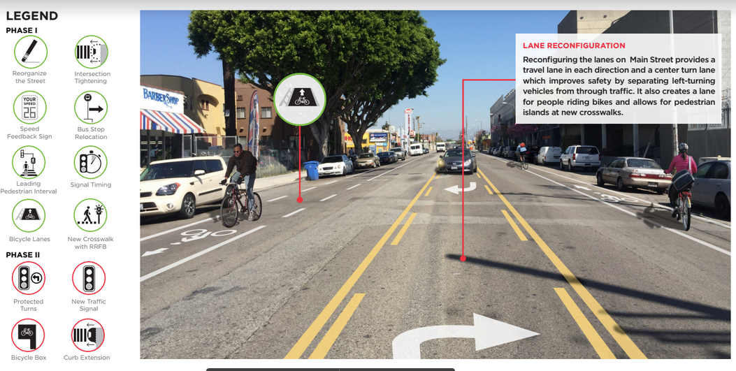
The legend for the maps seen below. Green circles indicate phase 1 improvements. Red circles indicate fixes that require more time and/or design and will be part of phase 2. Source: Vision Zero
Over the last several weeks, the city held four workshops in South and Southeast Los Angeles to introduce residents to plans to improve traffic safety along several key corridors. The plans are part of the push to achieve Vision Zero - the reduction of traffic deaths to zero by the year 2025.
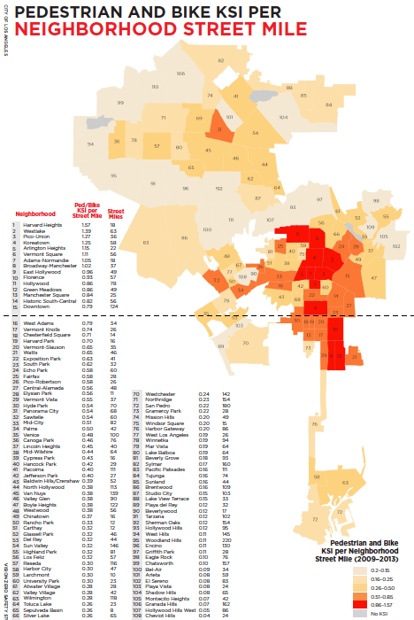
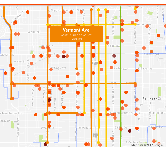
The focus on South L.A. is due to the high rate at which pedestrians and cyclists are killed or severely injured (KSI) in collisions with vehicles. Case in point - sixteen of the twenty-five most dangerous neighborhoods for cyclists and pedestrians called out on the map below are in South L.A.
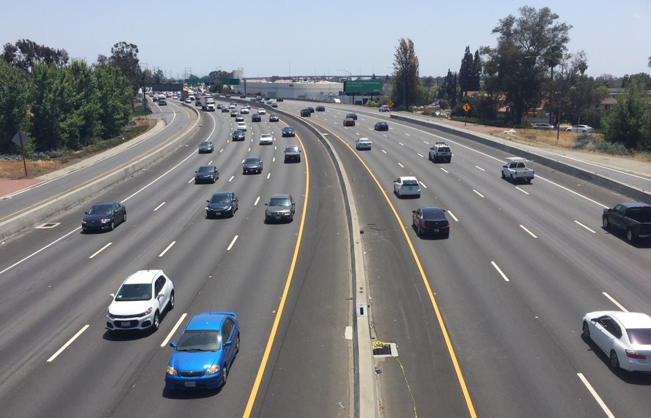
That reality should surprise no one who lives or moves through the area, unfortunately: South L.A. is home to wide and fast-moving corridors (speed is a major factor in the severity of injury), limited pedestrian and bike infrastructure, and a lower-income population that is more dependent on transit, biking, and walking than other areas of the city.
The rush to engage South L.A. on Vision Zero is tied to the city's ambitious goal of reducing traffic deaths by twenty percent by the end of 2017.
Things haven't gone well so far.
Traffic deaths actually rose last year: 260 died in traffic crashes, a forty-three percent increase from 2015. And as of April, 2017, the L.A. Times reports, traffic deaths were already twenty-two percent higher than they were during the same period in 2016.
Which may be why low-cost fixes aimed at enhancing the visibility of crosswalks or deterring drivers from making quick right turns have already popped up around South L.A. and other trouble spots around the city in the last couple months.
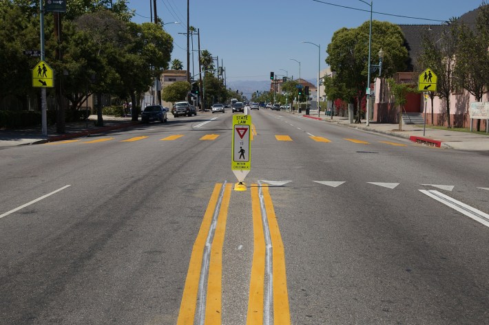
The effectiveness of the recent interventions along Vermont, Hoover, Normandie, and Central has yet to be determined. While it is never a bad idea to enhance the visibility of crosswalks or limit a driver's ability to make a fast right hook, according to the city's own calculations, the greatest dangers to vulnerable road users include left-turning drivers, speeding vehicles, and the time of day (dusk is particularly dangerous) - things these interventions don't address on their own.
But added to other planned upgrades, they have the potential to contribute to the overall slowing of speeding traffic, giving cyclists and pedestrians some much-needed breathing space.
Potential fixes presented to attendees at a workshop at County Supervisor Mark Ridley-Thomas' constituent center last week included new lighting and signals for crosswalks (in addition to more crosswalks), speed flashback signs, painted (and, eventually, concrete) curb extensions, and signals giving pedestrians a head start on crossing the street before cars would be able to turn right.
Attendees were asked to take a look at maps of the major corridors that will be targeted for improvements and to call out intersections or other sections of the streets that were particularly problematic.
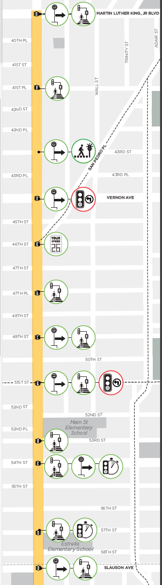
On the map of the section of Main between King Boulevard and Slauson (at right), for example, the city appears to have already determined that it would be safer for pedestrians if bus stops up and down the corridor were shifted to accommodate better infrastructure at crosswalks (signals that gave pedestrians a head-start on crossing the street before lights turn green, zebra striping, or new crosswalks helping transit riders get to bus stops more easily) and safer for all if a speed feedback sign was placed around 46th, signals were timed closer to Slauson, and protected turns were implemented at 51st and Vernon.
The green circles indicate fixes that would be part of the first phase of improvements; the red circles refer to phase two improvements (the timeline on the phases is unclear, as yet).
Attendees engaged city staff on issues affecting the area's corridors and put post-it notes with their comments on each of the maps, highlighting issues and deficiencies that they thought merited specific attention.
Because South L.A.'s needs have been neglected for so long, however, conversations I had with attendees often went well beyond traffic concerns to touch on a broader range of long-standing safety issues, including safe passage for youth, profiling by law enforcement, gentrification, and prostitution seen along sections of Western and Figueroa.
Which means I didn't spend as much time poring over the maps as I should have. So I was grateful to find that some of the corridors folks were asked to provide input on were available for download on the Vision Zero LA website, in both English and Spanish.
The detail maps currently available are of
- Avalon - to see improvements between Jefferson and 120th
- Broadway - to see improvements between King and Century Boulevards
- Central - to see improvements between 17th and 35th
- Figueroa - to see improvements between King Blvd and Imperial Hwy
- Florence - to see improvements between Central and Crenshaw
- Hoover - to see improvements between Vernon and Manchester
- Main - to see improvements between King Blvd and 116th
- Vernon - to see improvements between Western and Central Avenues
- Western - to see improvements between Washington and Century
Not shown on the maps are the bike lanes planned for Hoover (between Vernon and Manchester), Avalon (between Jefferson and 120th), Main (between King and 92nd), and Broadway (connecting Manchester to the bike lanes that begin at 92nd, and creating a buffered bike lane between 92nd and Century). Those plans will be discussed at a public hearing slated for June 21, at the Ascot Branch Library (120 W. Florence Ave, near Main), from 5 to 7 p.m. Also not shown on the map (and not up for discussion at the June 21 meeting) are Metro's plans to rip out the train tracks along Slauson and install the Rail-to-River bike and pedestrian path between Crenshaw Boulevard and Santa Fe.
And because there is a flurry of activity around streets at the moment, there is also an open house this Thursday to discuss improvements planned for Crenshaw Avenue between Florence and 79th. That event is tied to the Great Streets Initiative and will run from 5:30 p.m. to 7:30 p.m. at West Angeles CDC at 6028 Crenshaw Boulevard. Those wishing to discuss safety improvements further north on Crenshaw - between 52nd St. and King Boulevard - can find Multicultural Communities for Mobility and L.A. Commons at the Juneteenth celebrations in Leimert Park this weekend, between 11 a.m. and 3 p.m., where they will be tabling as part of their Sankofa on the Shaw effort.
Those more interested in the overarching community plans for South and Southeast L.A. can attend the public hearing at the City Planning Commission on June 22 at the Crenshaw Christian Center (7901 S. Vermont Ave.) at 8:30 a.m. More about those plans can be found here.
Learn more about Vision Zero here. Feedback regarding the plans for Vision Zero improvements can be sent to visionzero@lacity.org.
Stay in touch
Sign up for our free newsletter
More from Streetsblog Los Angeles
Automated Enforcement Coming Soon to a Bus Lane Near You
Metro is already installing on-bus cameras. Soon comes testing, outreach, then warning tickets. Wilshire/5th/6th and La Brea will be the first bus routes in the bus lane enforcement program.

Metro Looks to Approve Torrance C Line Extension Alignment
Selecting the relatively low-cost hybrid alternative should help the oft-delayed South Bay C Line extension move a step closer to reality