Deadline Today for Input on Montebello Bicycle Master Plan
Tonight at the Montebello Civic Center, the city’s Planning Commission will vote on whether to adopt one of the more impressive Bicycle Master Plans SBLA has covered in the San Gabriel Valley. Of course, there is always room for improvement, and SBLA encourage stakeholders to take a look and write to the Commission should they find concerns.
The Bicycle Master Plan is part of Montebello’s first General Plan update in 50 years. For the most part, the corridors slotted for bikeways in the bike plan are the very same as those slated for redevelopment in the General Plan.
Below are four key plan maps showing present and future bikeways in Montebello.
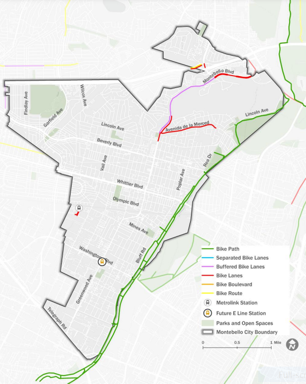
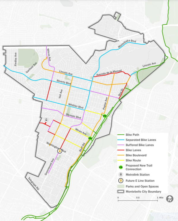
The above map shows existing bicycle facilities in Montebello. Much of it is about five miles of the County’s nearly 16-mile long bike path along the Rio Hondo. Additionally there are three on-street unprotected bike lanes on Montebello Road, Avenida de la Merced, and at the Montebello/Commerce Metrolink Station.
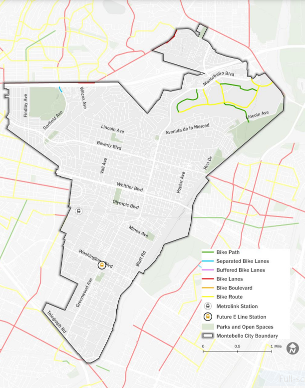
This map shows pre-existing plans for future Montebello bike facilities, all on the north side of town.
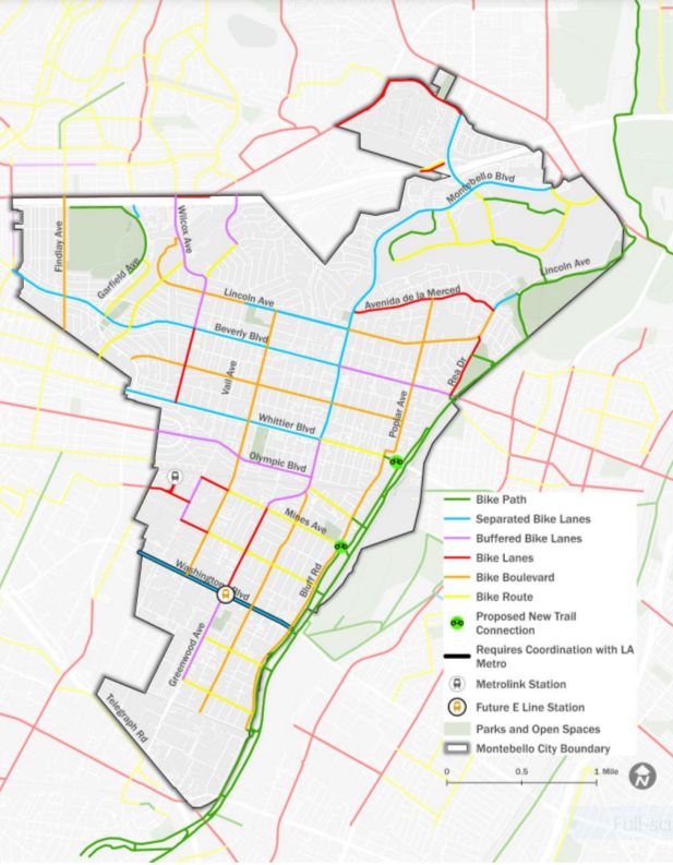
Above is the overall recommended Montebello Bike Plan, with an extensive network of bike lanes, many protected (which the plans calls separated) and some unprotected/buffered. The plan calls for protected lanes (see blue lines above) on:
- Paramount Boulevard
- Montebello Boulevard (north of Whittier Boulevard)
- parts of Lincoln Avenue
- Beverly Boulevard (west of Montebello Road)
- Whittier Boulevard (west of Montebello Road)
- and Washington Boulevard
The city has further prioritized the overall plan, identifying a backbone network of sorts. All the main east-west arterials are the Priority Bike Network, except Washington, which will need to be coordinated around the construction of the future Metro E Line Eastside Extension (anticipated to begin construction around 2030). The city’s main drag, Montebello Blvd., thankfully is part of this level of the plan too. Much of it currently has buffered bike lanes, but is known for being speedy and hilly, especially in the north.
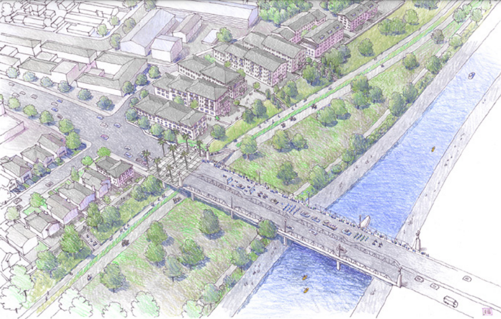
The plan calls for numerous bike path enhancements connected to the existing Rio Hondo path – including new access points and bikeways to, from, and along the waterway. At a public workshop on February 29, design consultant Kaizer Rangwala said the riverfront has “the potential to act almost as a north-south corridor, but not for vehicles – for pedestrians and bikes.”
Montebello’s Planning and Community Development Director Joseph Polombi added that there is a feasibility study to see if water can be kept in the Rio Hondo year round.
North and South Montebello
One recurring theme of the workshop – especially the General Plan, but also the Bike Plan – was the possibility of development on the city’s south side, below Whittier Blvd.
“Washington Boulevard is really a wonderful opportunity,” said Rangwala, “because you have large parcels, which you don’t have on Whittier. So redevelopment is a greater challenge on Whittier in the downtown and outside downtown on Beverly, than it is on Washington, because you have these large industrial parcels that could be reconceptualized as mixed-use development that is transit friendly.”
The perception among locals at the workshop was that north Montebello is the nice side of town, with higher property values and single family homes. Rangwala seemed to agree.
“We ran some numbers, and what we found is that the properties on the southern side of the city actually generate more revenue for the city than the parcels up north. And that is because you have a much higher density […] So in essence, what’s happening is this area is subsidizing the lifestyle up north.” he said.
Then Montebello resident and Traffic and Safety Commissioner Vincent La Rocca spoke up.
“I see a discrepancy in terms of the amount of infrastructure in the north side versus the south side, in terms of the amount of money going into the north side versus south side in this plan.” La Rocca said. “Obviously, separated bike lanes are more expensive. I live in the north side – and I’d love to see more separated bike lanes in the north side too – but there’s a lack of it in the south side. So that’s why I feel there’s a lack of equity in this. Obviously, there are road limitations in terms of size, and you don’t want to reduce car lanes because people get angry. But for people that rely on cycling or that want to start cycling in the south side, this is not going to promote or encourage them to ride.”
Michael Sahimi, Senior Planner for Kittelson & Associates, Inc. responded that residential parking and the number of driveways on Greenwood Avenue (the continuation of Montebello Blvd.) south of Mines Avenue made it tough to squeeze in more robust bike lanes.
Polombi also took this moment to clarify that Washington has an ambitious plan in the works.
“We have identified the entire stretch of Washington Boulevard as a separated bike lane. No other corridor has that in the city. We did it because after our traffic and safety commission meeting, we discussed the application that we have in Sacramento that hopefully will get funded, which is I think, a game changer, but we’re looking for parkways. And hopefully Metro will play with us as far as funding.” Polombi said.
After the meeting, La Rocca told SBLA that he is grateful that the city has developed this plan, despite his hope for more protected lanes to come on the south side of town.
“The whole city could use safety improvements.” La Rocca shrugged. “Luckily, with the Metro E Line extension, the south side will hopefully see more investment from Metro funds and local matches.”
The deadline to submit email comments to the Planning Commission is today, March 5, at 3 p.m. Send comments to pcpubliccomment@montebelloca.gov. The in-person meeting (agenda) will be held at 6:30 p.m. tonight at Montebello City Hall, with no remote participation.
Streetsblog’s San Gabriel Valley coverage is supported by Foothill Transit, offering car-free travel throughout the San Gabriel Valley with connections to the Gold Line Stations across the Foothills and Commuter Express lines traveling into the heart of downtown L.A. To plan your trip, visit Foothill Transit. “Foothill Transit. Going Good Places.”Sign-up for our SGV Connect Newsletter, coming to your inbox on Fridays!

Read More:
Streetsblog has migrated to a new comment system. New commenters can register directly in the comments section of any article. Returning commenters: your previous comments and display name have been preserved, but you'll need to reclaim your account by clicking "Forgot your password?" on the sign-in form, entering your email, and following the verification link to set a new password — this is required because passwords could not be carried over during the migration. For questions, contact tips@streetsblog.org.