Project Team Presents Three Options for PARC on Boyle Heights Side of Sixth Street Viaduct
Before residents were presented with the three design options for PARC – the 12-acre green space planned for underneath the rebuilt Sixth Street Viaduct – councilmember José Huizar opened Tuesday night’s meeting at the Aliso Pico rec center by announcing that he had just secured another $2 million in funds for the construction of the park space.
Because of the way federal funding for infrastructure is structured, he told the crowd, even though the reconstruction of the bridge will cost nearly a half a billion dollars, only five million had originally been available for fixing up the space underneath it.
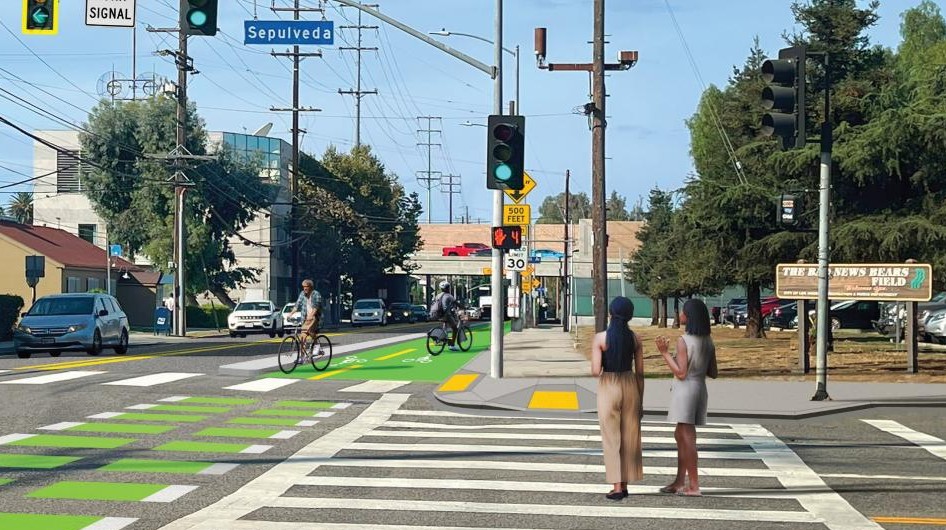
The newly acquired $2 million comes from Adelante Eastside CRA funds and brings the total number of dollars the city has cobbled together over the past couple of years to $25 million. The remaining four million needed to fully build out the park will likely come from Quimby funds (monies developers of new construction pay to fund parks and their upkeep), Huizar said. These funds will be in addition to the ten million secured for sidewalks, pedestrian lighting, crosswalks, stop signs, and the long-awaited signal at 4th and Clarence that will make accessing the park by foot, skateboard, bike, stroller, or wheelchair easier and safer.
Once it was made clear to residents that PARC would be able to move forward, the project team turned to the question of what form PARC should take.
At meetings held earlier this year, community members had been engaged on potential ways the park space could be approached as well as amenities it might feature. [See previous presentations here, under “community outreach”.] The approach that won out was called “Canopy and Objects,” whereby the long, straight lines created by the bridge itself would be softened by the use of ovals (to create unique spaces for activities or relaxation), meandering paths, and trees to provide shade in the spaces the bridge does not.
Tetra Tech, Hargreaves Associates, and Michael Maltzan Architecture then took the input from those community meetings and used them to create three potential designs that would fit within the “Canopy and Objects” approach to the space on the Boyle Heights side of the river (below, in pink).
At Tuesday’s meeting, the project team reviewed each of the options in depth for attendees and then asked them to vote on their preferred one.
The first option focused on creating space for sports.
As can be seen below, the park would include two turf soccer fields, an adult fitness circuit (at left), two courts that could be used for basketball or fútsal (red oval), smaller landscaped rest areas, a splash pad, picnic and barbecue areas, a play area for kids (yellow oval, center), restrooms, a dog park (at right), and grassy play areas that could double as soccer fields for smaller kids.
As can faintly be seen in the rendering above, the grassy areas could provide five grass soccer fields in addition to the two turf fields (dark green), including one for kids under ten years old, two for kids under eight, and two for kids under six.
While it might seem like an over-abundance of soccer-specific spaces, it is important to note that not only does Boyle Heights have one solitary soccer field for the entire community (outside of school fields), playing soccer is prohibited at parks because of the way it tears up the grass. This would help remedy that deficit while still allowing for other uses of those green spaces.
Looking eastward from the river towards Boyle Heights, that configuration would look something like what is pictured below.
Below is the view looking west toward the river and downtown from Clarence Street (some of the fields can be seen in the grassy area, at left, below). As can be seen, the sports-focused option means more paved-over surfaces and fewer trees.
The nature-focused option goes in the opposite direction. It keeps the two turf fields (dark green) and smaller grassy fields, but removes the two basketball/fútsal courts altogether, creating both a bigger play area for kids (at center) and adding a bit more greenery.
Looking toward downtown from Clarence Street, the difference in tree canopy is substantial.
The same is true of the view looking east towards Boyle Heights.
The “balanced” option brought in elements from both designs, keeping one basketball/fútsal court (now in a smaller red oval and closer to the turf field) and reserving larger areas for walking, relaxing, and playing.
The model suggests how the “balanced” option would interact with the bridge structure and the shade it will cast, below.
In addition to talking about potential designs, presenters asked how the plaza might be used for cultural expression. Each of the three options carved out picnic spaces, versatile stages, and spaces where vendors could set up for a variety of activities, including movie nights, quinceañeras and family gatherings, performances, farmers’ markets, and mariachi festivals.
Below, in pink, are family-friendly areas present in all three design options, including an area that is apparently meant to be camera-ready for family and quinceañera portraits and, of course, selfies (“sitio para tomar fotos dentro del jardin”).
Potential performance space (“escenario”) configurations can be seen in the three options presented below.
All three options feature two larger stages/spaces that could hold about 2,800 people total. The “sports” option (“deporte”) would also feature a smaller performance space that could be set up on the fútsal courts and was able to hold about 700 people. The “balanced” option would also allow for an additional small performance space that could hold about 500 people.
Although it’s not called out above, the leftmost “escenario grande” present in all three options could also be converted into a space for mobile movie screenings.
The park space on the west side of the river will feature a larger and more formal arts performance space paid for, in part, by a $1.9 million donation from arts patron Leonard Hill (his donation also covers three years’ worth of arts programming) and feature unique lighting intended to highlight the space.
The performance plaza will take up the bulk of the section closest to the rail lines (below).
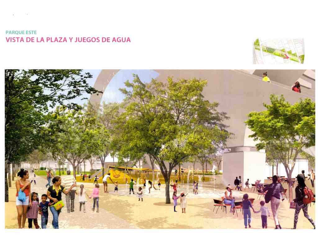
The rest of the western park space will feature a walking path, green space, trees, a fitness area, a dog park, and a grassy area for play or performances. The park will also feature a ramp leading pedestrians and cyclists up to the bridge deck.
There will be several sets of stairs allowing access to the bridge deck on both sides of the river. The main circular ramp (below), which will allow cyclists and those using wheelchairs or strollers to access it, will be located on the east side of the river, adjacent to Mission Road.
When attendees finally had the chance to weigh in on the plans for east side, most voted for the “balanced” design, preferring the mix of natural elements and spaces for activities. The only consistent complaint about all three designs was the lack of planning for a skate park.
Garage Board Shop owner and youth advocate Jerry Garcia, who had brought some of his young skaters with him to the meeting, stood to ask why skate facilities had not been incorporated.
Arguing that youth were going to use the space regardless of how many anti-skate obstacles the city installed and underscoring how important it was that the youth not be criminalized for trying to enjoy the space, he implored the project staff to take the youths’ well-being into consideration.
After hearing several attendees agree that this was indeed something that they considered to be a high priority, the project team agreed to look into the possibility of adding skate facilities.
The team is still gathering feedback on the PARC designs. If you would like to comment on the project or vote for one of the three options, you can do so via the Sixth Street Viaduct website or their Facebook page.
More questions about the bridge? See some of our previous coverage below.
- February, 2016: Hide Your Wife! Hide Your Kids! Freeway Closure for the Demolition of the 6th St. Bridge is upon Us!
- July, 2015: Filed Under: Hidden Gems in Fact Sheets. A Protected Bike Lane for the Sixth Street Viaduct
- February, 2015: The 6th St. Viaduct Replacement Project Officially Breaks Ground; Actual Breaking of Ground Is Yet to Come
- October, 2014: Final Sixth Street Viaduct Model Showcased at Public Briefing; Expected Completion Date, Early 2019
- July, 2014: Sixth Street Viaduct Replacement Project Takes Another Step Forward
- December, 2013: Public Briefing on Sixth Street Viaduct Highlights Need to Remember Bridges are about Connecting People
- September, 2012: Competing Visions for 6th Street Viaduct “Iconic,” but Residents’ Concerns More Practical

Read More:
Streetsblog has migrated to a new comment system. New commenters can register directly in the comments section of any article. Returning commenters: your previous comments and display name have been preserved, but you'll need to reclaim your account by clicking "Forgot your password?" on the sign-in form, entering your email, and following the verification link to set a new password — this is required because passwords could not be carried over during the migration. For questions, contact tips@streetsblog.org.