Public Briefing on Sixth Street Viaduct Highlights Need to Remember Bridges are about Connecting People
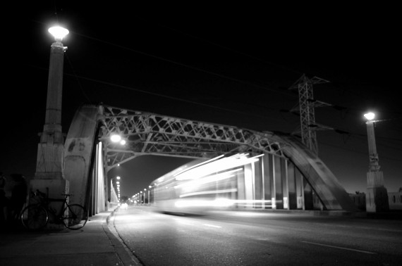
A bus crosses the 6th Street Bridge into Downtown. Sahra Sulaiman/Streetsblog L.A.
"Wow, it's dark," I noted as I rode across the 6th Street bridge the other night. "Why are all the lights off?"
I had just left the public briefing on the 6th Street Viaduct Replacement Project where representatives from the Bureau of Engineering (BOE), the contractors Skanska & Stacy/Witbeck, and the Public Arts Advisory Committee (PAAC) had offered an update on design and construction dates and wanted to contemplate some of what I had heard while crossing the structure itself.
It's my favorite bridge in the city. The 3500 ft. span, beautiful views, and overall spaciousness have a unique way of opening up all the doors and windows in my brain and letting fresh thoughts blow through.
The eerie atmosphere created by the unexpected blackout, however, seemed somehow portentous.
Change was in the air, and not everybody is happy about it.
For the most part, people seem to understand that the bridge needs to be demolished and rebuilt.
The alkali mixed in the concrete, when exposed to moisture, triggered an alkali-silica reaction that has been eating away at the strength of the bridge almost since the moment construction was completed in 1932. The deterioration was so rapid, in fact, that it necessitated the removal of two large decorative pylons in the 1940s, the stripping of the asphalt and recoating of the underlying concrete in the 1980s, and multiple epoxy patch jobs in recent years. Estimates that the bridge has a 70% probability of collapsing in a major earthquake are also rather persuasive in that regard.
And many seem to appreciate that the city is treating the bridge as an iconic structure and looking to replace it with one that will be equally iconic.
What people are having more trouble with, however, are the details of how (and using which guidelines), construction will be undertaken and, much like in the case of the Glendale-Hyperion bridge, the seeming reluctance of the city to think of a bridge as more than a stand-alone entity.
With regard to the question of details, a number of attendees raised questions about the fact that the contractors were working from an EIR completed in 2006.
Much has changed on both sides of the bridge since then. There is much greater residential density on the downtown side, in addition to a number of new businesses and art spaces that both serve that new population and draw people from all over the city.
Traffic has also increased dramatically along streets like Santa Fe and Alameda since 2006, several people from that area testified.
Detouring traffic through residential and business corridors, they suggested, would therefore significantly impact the quality of life in the area and, potentially, the ability of small businesses to weather the construction period.
Folks on the Boyle Heights side, where the arts community has also grown in recent years, had similar concerns.
All of them wanted to know how exactly the contractors and engineers were factoring the new socio-economic realities of the area into their plans.
Alfred Mata, Project Manager from the BOE, countered that the 2006 EIR (found here and here) was still valid and it was legal for them to work from it. But, he noted, they weren't opposed to learning more about how the neighborhoods had changed.
"So... that's what we [should] encourage all our neighbors to do? To inundate you with, 'I'm here, this is who I am, this is my business...'?" a resident of the downtown side asked, a little incredulous at the idea that there would be so little engagement of neighbors in such a massive project.
Getting affirmative nods and giggles from the audience, he shrugged resignedly, "Alright. Thank you."
Residents of the flats -- the area beneath the bridge -- were concerned about whether or not they would have a home once the project was finished. Or if the demolition process would be so noisy and kick up so much dust that the place would become unlivable.
"I find it very difficult to get any information about what my rights are," said a man who has a studio under the bridge at Clarence and Jesse. Everyone he talked to, he said, had told him something different.
Then he asked about whether perhaps he wasn't being told everything he needed to know about the future of his studio. On the renderings, he said, "you can see our building in the first couple photos." But the building later disappears and is replaced by gardens.
"Are there different phases of construction, [like] the demo of the building and then gardening?" he asked. "It's an honest question...would it be an eminent domain later versus now? These are questions we can't get answers to. At all."
With regard to seeing the bridge as more than just a bridge, Raul Gonzalez of ES Studios asked why the improvements stopped just after the 101 fwy, well short of Boyle Heights.
Why not extend them to the intersection of Boyle and Whittier and include those business owners and residents in the project? People from the area also wanted to be part of it, he said.
"Are we still included in the plans?" he asked, taking a dig at the team's outreach efforts. "I'm just wondering how much of the local businesses will be a part of the [project]...because most people from Boyle Heights are not here. I'm just saying..."
The issue of connectivity was one that he and others had raised with the representatives before. And, according to them, it was one the city said they took took seriously and asked the contractors to take back to the drawing board.
But, the current plans still seem to be devoid of any intention to bond the community with the bridge.
"It's a bridge replacement project," Mata reminded the crowd.
And that may be the problem.
The funding for the project, which comes primarily from the Federal Highway Bridge Program and is supplemented with matching funds from the State Proposition IB Seismic Safety Retrofit Program, has to be directed towards creating a sound structure.
Funds left over for landscaping the proposed terrace and park spaces below the bridge or a public art project are minimal. And, integrating the bridge with the community more organically falls outside the scope of the project altogether.
Which I suppose should be a surprise to no one -- that's how project funding works.
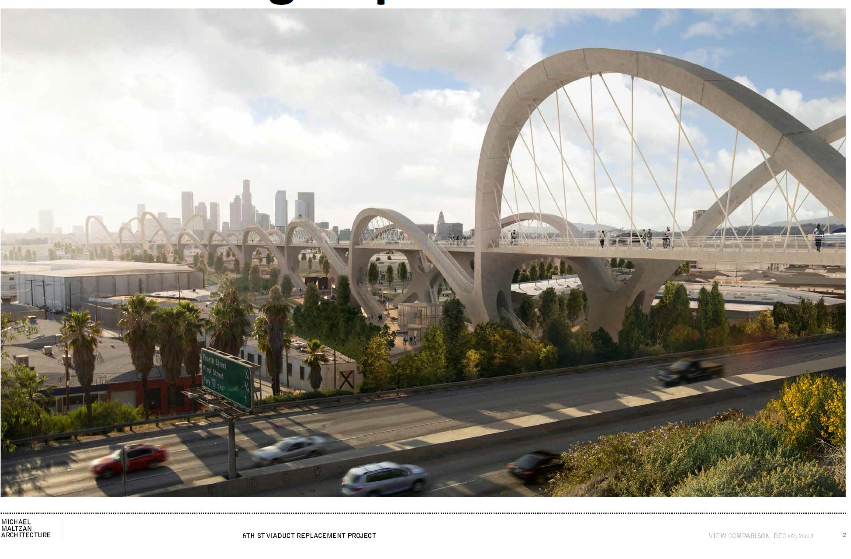
But knowing this, it is unclear why the city -- so proud of the unique opportunity to create a new iconic structure -- didn't take advantage of this important opportunity to think about the bridge as more than a stand-alone structure.
I mean, yes, the plans offer what appear to be a lovely promenade space along the span of the bridge as well as access to the river and a park space below -- all of which is geared towards making the bridge a more recreational structure.
As glorious as it and its LED-lit arches may eventually be, however, the bridge still feels very self-contained and separate from the surrounding communities. Especially Boyle Heights.
It's physically disconnected in that those from the downtown side may not feel drawn to visit the east side, given that the improvements halt 800 ft. and a freeway on-ramp short of the community. The message to those standing at the edge and looking eastward is --"Eh, you've gone far enough. If we thought there was something for you to see there, we would have made passage to the community more inviting."
Those on the Boyle Heights side may not be as drawn to the bridge, either, given the unpleasant task of crossing an on ramp and the implicit message sent by the lack of infrastructure that this bridge may not be for them.
Beyond the tangible physical issues, the project would benefit from treating the bridge as the vital connective tissue between neighbors that it represents.
While maps might tell you the arts districts lie in Gallery Row downtown or along 1st St. in Boyle Heights, the viaduct happens to link two very different but vibrant and evolving arts communities. As such, the bridge might be better conceived of as an arts corridor, spanning a diversity of styles, techniques, cultures, and histories in a single bound. More incorporation of the spirit and artwork of people from the area would help showcase the communities on either end of it as well as to strengthen the bond between them.
In her presentation on the arts committee, Felicia Filer from the Dept. of Cultural Affairs, seemed to understand the need for more attention to this issue. She acknowledged that the designated arts allotment from the construction budget was small -- just $1.3 million -- and that they would likely dedicate that funding toward an iconic public art installation (as yet undecided) that responded to the architectural vision of the bridge.
"We think we can come up with another solution to help address some of the needs of the muralist community," she said of the desire to avoid shutting local artists and the muralism culture out of the project altogether. But, because of the funding issues, that will have to happen "through another program."
Mulling all this over as I rode home across the dark bridge after the meeting, I was dismayed to think that, like with the Hyperion bridge project, we have an opportunity to create something that is more than just a structure filling a gap. And, like with the Hyperion bridge project, the powers that be are slow to understand that infrastructure is ultimately about connecting people. The more human-centric and human-scaled the infrastructure is, the more openings there will be for people to make those human connections, and the more successful the structure will be.
+ + +
UPDATE: A selection of this post speculating on the absence of bike lanes has been deleted. There will be bike lanes on the roadway. The bike lanes were not visible in the renderings and the only answer I had been able to get when asking about the possibility of bike lanes directed me to look at the renderings. Thank you to Nat Gale for getting confirmation from the project manager that plans do indeed include bike lanes.
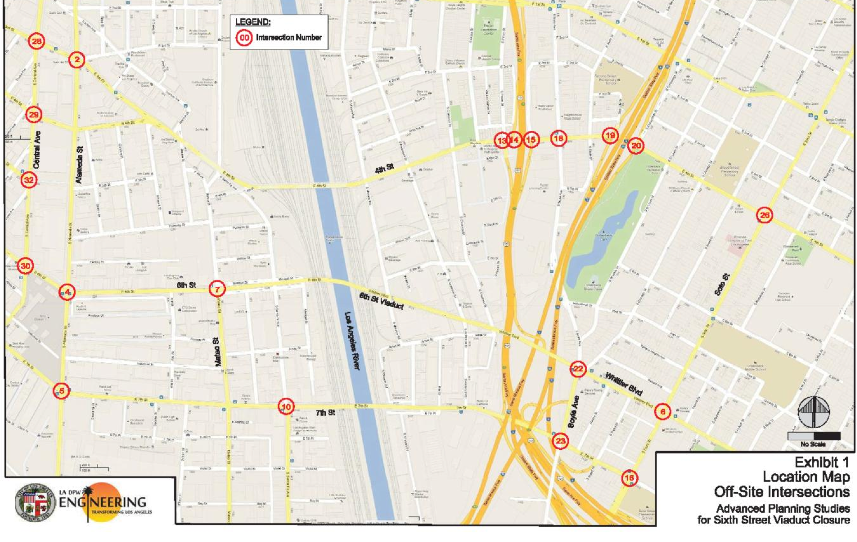
If you'd like to see a video of the briefing, click here. The power point presentation from the briefing is here. The design of the bridge is expected to be 90% complete in January of 2014. Improvements at 20 intersections around the bridge are slated to begin over the summer (and continue til the spring of 2015), but demolition of the bridge itself will not begin before December of 2014. The bridge entrances will be closed between 6 and 9 months, and much of the demolition work on or near the freeways and railroad tracks will be done at night. An earlier presentation on intersections can be found here, although it appears that some of the targeted intersections have changed since this April draft. Other documents can be found on the project website.
Stay in touch
Sign up for our free newsletter
More from Streetsblog Los Angeles
No, L.A. City Does Not Always Add Required ADA Ramps During Resurfacing, But They Should
StreetsLA GM Keith Mozee "Any time we do street resurfacing, it is considered an alteration, which requires ADA ramps to be installed."

LAPD Was Crossing Against Red Light in Crash that Killed Pedestrian and Injured Six in Hollywood
The department says the officers had turned on their lights and sirens just before crossing, but won't say why they did so.