It’s Not Good Transit If the Streets Nearby Aren’t Good for Walking
All transit stops aren’t created equal. The street environment around the station — especially safe, convenient pedestrian access — has a major influence on how people use transit.

Edward Russell at Greater Greater Washington compares two stops that offer very different walking environments — one in San Diego and one in Washington:
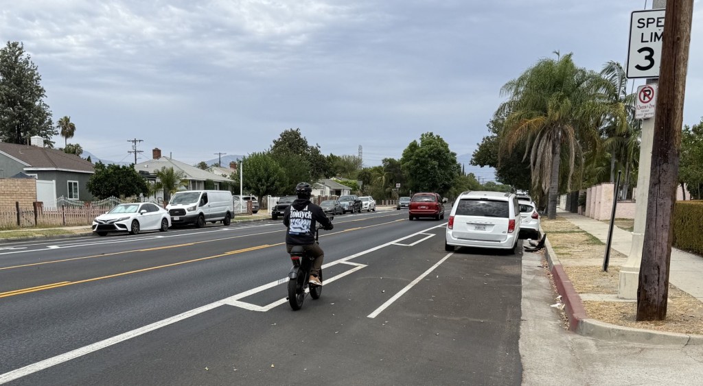
The 1.1-mile walk from the Grossmont Trolley station in the San Diego suburb of La Mesa to my family’s house takes you through a strip mall parking lot, along the six-lane major arterial Fletcher Parkway and then up the overly wide four-lane Jackson Drive before you turn into their neighborhood. It’s not pleasant, as the picture above shows.
As a result, my family only drives to the station when they ride the Trolley, and I — someone who likes to ride transit — think twice about making the walk when I’m there.
The crazy thing is that this is a comparable distance to what I walk a couple of times a week from the Shaw-Howard U Metro station to my house in Eckington.
What’s the difference? The walk in DC is along leafy streets lined with rowhouses in the Le Droit Park and Bloomingdale neighborhoods. Yes, I cross three major roads — Florida Avenue, and North Capitol Street and Rhode Island Avenue where they meet — but it is just two intersections, and I do not walk along either street for very long.
The Grossmont stop, Russell says, is “a reminder that simply building transit is not all that it takes to make a suburban neighborhood walkable and generate new transit ridership.” What suburbs like La Mesa need to do is rethink not only street design but also car-centric development patterns near transit stations.
Elsewhere on the Network today: Project for Public Spaces reports on a community-based initiative in St. Paul to reconnect neighborhoods that have been disrupted by an old urban freeway. Bike PGH explains how the “Dutch Reach” can help drivers and car passengers avoid dooring cyclists. And The Urbanist says that Seattle is considering ways to fast-track infill development.

Read More:
Streetsblog has migrated to a new comment system. New commenters can register directly in the comments section of any article. Returning commenters: your previous comments and display name have been preserved, but you'll need to reclaim your account by clicking "Forgot your password?" on the sign-in form, entering your email, and following the verification link to set a new password — this is required because passwords could not be carried over during the migration. For questions, contact tips@streetsblog.org.