Santa Monica city staff presented the beginnings of the developing Bergamot Area Plan to the Planning Commision Wednesday night for feedback, offering a promising look at what Santa Monica’s eastern transit oriented district might feel like. As part of the implementation of the LUCE general plan, a number of specific plans are being created involving their own public outreach process. Several large workshops were completed for the Bergamot area in recent months, offering direction that is shaping the drafting of the document.
Several developments in the vicinity of the rail line are already proposed, and are floating around in the complicated development agreement process for projects that deviate from traditional zoning. This deviation is now common because many expect changes in the zoning code soon in compliance with the circulation element, including the Hines creative office and mixed use residential project on the site of the old Papermate factory on the North side of Olympic Boulevard.
These proposed developments contain new public streets, bike and pedestrian paths cutting through parcels. All of the new development agreements go through rigorous scrutiny to work out the details. The city is clearly intent on not repeating the mistakes of fortress like and mostly single use superblock developments such as the the Yahoo Center and Water Gardens.
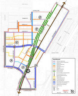
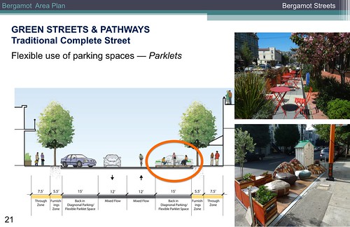
The emerging plan outlines a new street hierarchy, with what are being called “traditional complete streets”, “flexible streets”, and “shared streets.”
Advocates are familiar with "traditional complete streets" which include standard sidewalks, street parking, vehicle lanes with bike lanes or sharrows. Flexible streets allocate more sidewalk space to one side for a broader pedestrian environment offering the potential for outdoor seating and other uses. Shared streets are more akin to the recent redesign of Longfellow, where there is no curb separation and calming methods are used to bring vehicle speeds to a level safe for mixing bikes, peds and cars.
Pennsylvania Ave., proposed as a shared street, known by many area workers as “food truck alley”, already functions as a shared street during weekday lunches. This is happening despite the lack of supporting design features, due to low traffic volumes and lots of people on foot with no sidewalks. However the comfort and feel would be greatly enhanced with further traffic calming and places to sit besides stairs, curbs, and dull landscaping berms.
There is still much to be ironed out before the Bergamot Area Plan is ready for implementation, but what can be seen of the plan taking shape so far is far above and beyond what I have seen from other communities that have had Metro rail come through, or are anticipating future rail investments. Everything in Santa Monica’s planning efforts anchors around on the 3 new rail stations in city limits that will be part of the Expo Line, with circulation to and from each station being thought out for every mode of travel.
Santa Monica is demonstrating how a community should synchronize with rail investments to both maximize potential ridership and return on investment in economic activity and property values. There are some in the community who will find fault with the new developments coming in with Expo, but leveraging big infrastructure investments for ongoing financial returns is how we keep our infrastructure funded and maintained for the long haul.
Santa Monica does have more resources to work with than many cities it’s size, but many of the proposed improvements such as connecting bikeways are low cost and can be accomplished easily anywhere with the will to act. So many American infrastructure investments have been highways to sprawled exurban communities, creating miles of asphalt that will never fully recoup their costs and instead become crumbling liabilities at the end of their effective life. Concentrated development around rail is how we build a rapid transportation network that can actually pay for itself in a sustainable fashion.
When I look out at the acres of lumpy surface parking surrounding the Culver City Expo station opening this summer, I cry a little bit inside. So much of the land use along our new rail corridors in the LA region are strings of missed opportunities to create new value, or projects which are transit adjacent, rather than truly oriented around using the train. In Santa Monica I fully expect Phase II of Expo will open with a much deserved splash that starts reaping dividends for the city on day one, with new projects positioned to take full advantage of rail access along with improvements to multi-modal circulation that will enable seamless car-free travel.
The planning commission agenda website contains the full staff report and slide presentation (item 10-A).
