
Pedestrian Impressions 2: Walking Downtown
A couple of weeks back, I had a meeting in the Metro Building two hours after a meeting in the Downtown Library. I decided to walk to the Metro HQ and back. The route was roughly this, but I took off down side streets a lot. Following the map is another photo essay…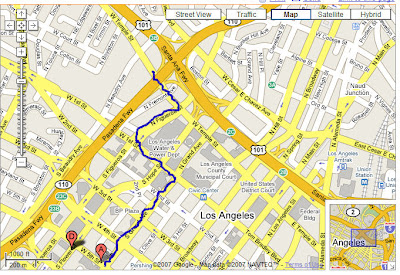


Proof that wide sidewalks and streetscaping alone are not enough to get pedestrians to use a sidewalk.

Never let anyone tell you that nobody takes transit. In this picture, a crowd squeezes through the tube to start their trip home after work.

Is there a bigger waste of land resources than at street parking? Literally acres of downtown are eaten up with what could be accomplished with a few large parking garages. Thing of what this view of the downtown skyline could be from a park.

What a beautiful side of a wall this is! I would say the majority of the walk was next to walls.

Streetsblog has migrated to a new comment system. New commenters can register directly in the comments section of any article. Returning commenters: your previous comments and display name have been preserved, but you'll need to reclaim your account by clicking "Forgot your password?" on the sign-in form, entering your email, and following the verification link to set a new password — this is required because passwords could not be carried over during the migration. For questions, contact tips@streetsblog.org.

