
Rundown of New Federal Reconnecting Communities Grants for L.A. County
There are seven L.A. County Reconnecting Communities grants totaling $162 million - about 90% of that goes to Metro's Removing Barriers project, which includes new bus lanes, first/last mile walk/bike facilities, bike-share, and more.
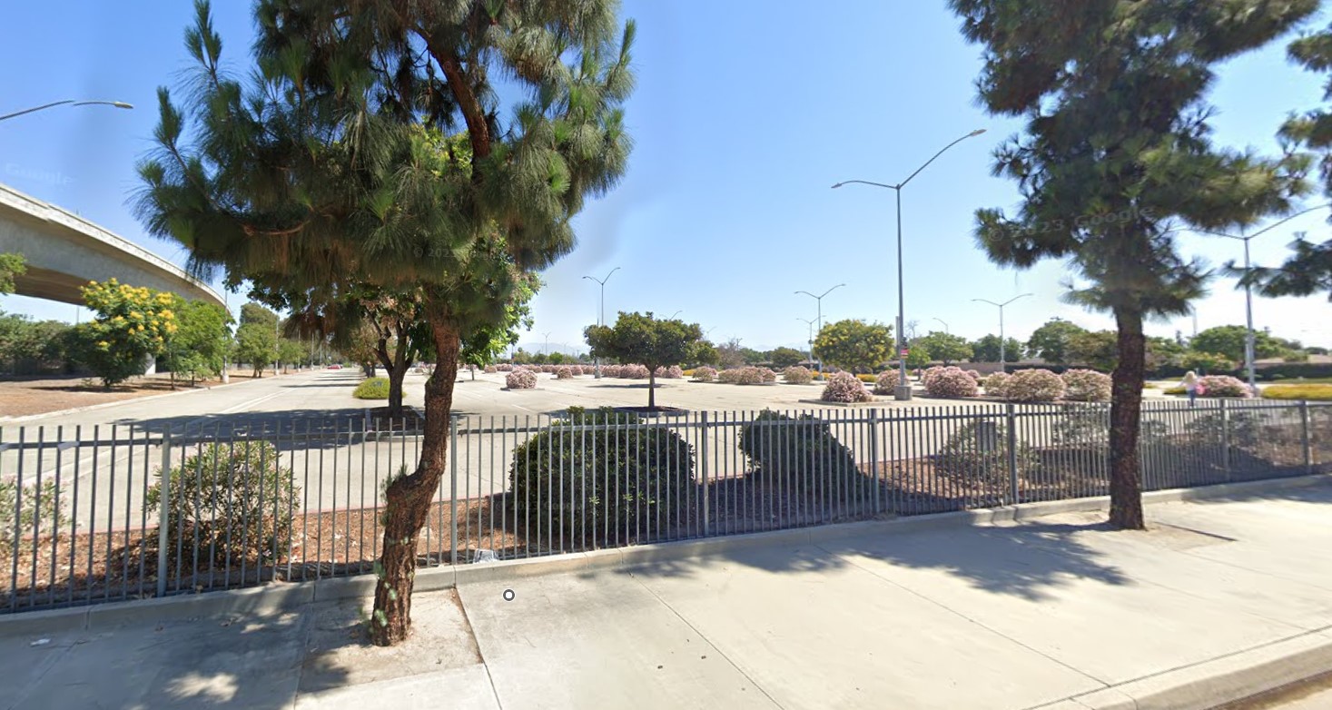
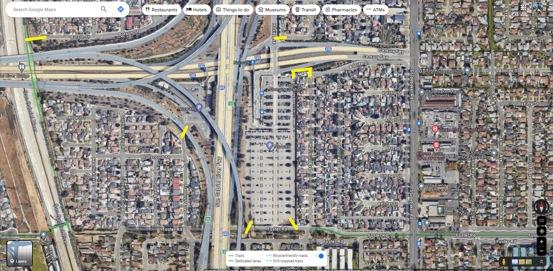
As part of its “Removing Barriers and Creating Legacy” Reconnecting Communities grant, Metro will add bus lanes, bike lanes, bike-share – and will add a bike/walk connection through this fence at its Norwalk C Line station. Photo via Google Street View

Last week, the federal U.S. Department of Transportation announced its Reconnecting Communities & Neighborhoods (RCN) Grant Program awards. The purpose of the program is to "repair the harm caused by infrastructure choices of the past" originally mainly to help neighborhoods remove freeways that cut through communities of color starting a century ago and still taking place today.
The grants are a mixed bag. There aren't many freeway removals (none in California) and some freeway-building agencies are securing grants for things like freeway lids over freeway widening projects. Many projects add transit/walk/bike facilities in those awful loud polluted car-traffic-congested spaces around and along freeways. Needed, yes. Restorative, not quite.
For the entire United States, RCN grants totaled $3.3 billion. While that might sound like a lot of money, it's the same as the total budget of the two L.A. County 5 Freeway widening projects Metro completed last year. It's not an apples-to-apples comparison, but the entire nation is dismantling freeway harms at about the same rate as L.A. County is expanding that harm.
California RCN grants totaled $237 million. Of that, L.A. County secured about two-thirds: $162 million. Of the L.A. County total, more than 90 percent went to Metro, nearly all of that for one $139 million grant.
RCN grants go to governmental agencies and/or nonprofits - for capital, planning, or regional partnerships.
Below is the list of L.A. County RCN grants (in the same order as on the federal listing), followed by details on selected L.A. grants. (See USDOT factsheets for one-page project information for each grant.)
- $5 million to the Port of Los Angeles for the Rail Mainline/Wilmington Community & Waterfront Pedestrian Grade Separation Bridge - capital. The planned pedestrian bridge (over rail tracks and Water Streets) will connect Wilmington Waterfront Park to the actual waterfront portion of the park, a promenade that opened in February.
- $9.96 million to Metro for the 710 Freeway Humphreys Avenue Crossing: A Pedestrian and Bicycle Crossing to Bridge the 710 Divide in East L.A. - capital. Metro has long planned to retool the Humphreys bridge (over the 710) as an early action project in its planned (now partially canceled) lower 710 Freeway widening. This project will construct a separate new ped/bike bridge there.
- $800,000 to L.A. County for the Reconnecting East Los Angeles: 60 Green Bridge Project for Belvedere Park - planning. The county will plan a cap over the 60 Freeway bridging the two sides of Belvedere Park, near the East L.A. Civic Center, the current terminus of the Metro E Line.
- $1,200,000 to Long Beach for Reconnecting North Long Beach - Hamilton Loop Project - planning. Long Beach will plan a two-mile loop along both sides of the 91 Freeway (where Metro is currently widening it). The Hamilton Loop project is anticipated to include a pedestrian path, protected bike lane, community gardens, landscaping, play and fitness equipment, a dog park and picnic areas.
- $2 million to L.A. City for Reconnecting MacArthur Park - planning. This project, championed by L.A. City Councilmember Eunisses Hernandez, will permanently close Wilshire Boulevard from Alvarado Street to Carondelet Street.
- $3.6 million to Friends of Hollywood Central Park for Healing Hollywood - planning. The nonprofit organization FHCP is planning a large scale (37.6 acre) park capping the 101 Freeway, which will include five miles of walk/bike paths, and much more.
- $139 million to Metro for Removing Barriers and Creating Legacy ‑ A Multimodal Approach for Los Angeles County - regional partnership. Description is below.
(One more RCN project will plan a connection to L.A. County: the San Bernardino County city of Montclair received a $750,000 planning grant for its San Antonio Creek walk/bike path, which will end at Mission Boulevard, adjacent to the city of Pomona.)
Metro describes their "Removing Barriers" project as "14 miles of bus priority lanes, 23 miles of bus corridor enhancements (i.e. transit signal priority, all door boarding, and bus shelters), 60 Metro Bike Share stations" plus first-last-mile improvements, five mobility hubs, "and various supportive programs and operational strategies." Metro's grant submission [pdf - posted by @numble] clarifies those bus improvements are centerline miles, as opposed to lane-miles.
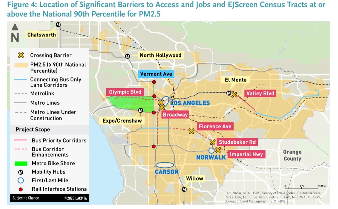
The $139 million Metro bundle tees up lots of improvements in many parts of the county - from South L.A. to the Valley to West L.A. to the cities of El Monte, Carson, Long Beach, Norwalk, and more - generally around, along, and/or across freeways.
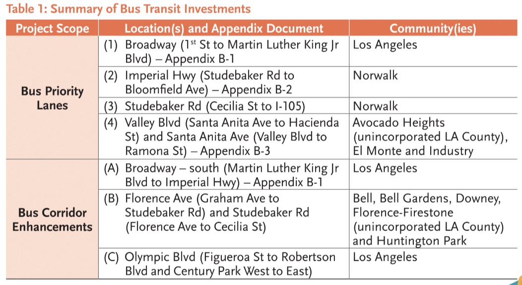
Bus-only lanes will be installed on:
- Broadway - 3.5 miles from Martin Luther King Jr. Boulevard (in South L.A.) to First Street (in downtown) - in the city of Los Angeles.
- Imperial Highway - 2.0 miles from Studebaker Road to to Bloomfield Ave - in the city of Norwalk
- Studebaker Road - ~1.0 mile from Cecilia Street to the 105 Freeway - in the city of Norwalk. [There's a slight discrepancy in Metro's application: Metro and USDOT maps show this ending at Imperial, a couple blocks short of the 105.]
- Valley Blvd (Santa Anita Avenue to Hacienda Street [sic]) and Santa Anita Avenue (Valley Boulevard to Ramona Street [sic]) - totaling ~6.6 miles through unincorporated Avocado Heights, and the cities of El Monte and Industry
Additional "bus corridor enhancements" will also be installed on Broadway (in South L.A. - from MLK to Imperial - where the city of L.A. plans to install bus lanes), Florence Avenue (in several southeast L.A. cities) and on Olympic Boulevard (from downtown to Century City).
Metro Bike Share expansion will close the gap between the central L.A. service area (ending roughly in Koreatown) and the Westside service area (roughly ending in Palms) - see green area on Metro map above.
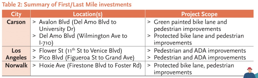
Metro's Removing Barriers grant specifies several first-last-mile walk and bike facilities. Walk improvements will be installed on Flower Street and Pico Boulevard (both in downtown Los Angeles). Bikeways - with pedestrian improvements - will be located on :
- Avalon Boulevard - 0.75 mile of painted bike lanes from Del Amo Boulevard to University Drive - in the city of Carson.
- Del Amo Boulevard - 1.7 miles of protected bike lanes from Wilmington Avenue to the 710 Freeway - in the city of Carson - connecting to the Del Amo A Line Station. According to Metro, the facility will include seven intersection improvements (apparently protected intersections?) consisting of refuge islands, ADA ramps, high visibility crosswalks, and leading pedestrian intervals. Metro states that the facility will connect to the L.A. River bike path (which would mean bike-friendly Long Beach extending the bike lanes another fifth of a mile).
- Hoxie Avenue - ~1.0 mile of protected bike lane from Firestone Boulevard to Foster Road in Norwalk. Hoxie is the north-south street paralleling the 605 Freeway terminating in the Norwalk C Line Station parking lot. That mid-freeway light rail station has long been a terrible place to get to on foot or bike, as fences/walls block all access to the west, south and east - forcing transit riders (ones who don't walk/bike illegally along the freeway) to take circuitous trajectories up desolate Hoxie, then along heavily trafficked Imperial Highway. Hoxie does not intersect Foster Road (which runs along the south side of Norwalk Station parking lot). Metro hasn't shared the facility design, but the application give some indication of their plan, "In the last decade, bicyclist injuries and deaths on Hoxie Ave and neighboring streets have prompted Metro to seek funding to improve bicyclist safety and to create safe connections to the existing dedicated bicycle facility on Foster Road." Further Metro states that Hoxie will connect to Foster on a "dedicated bike route via the station parking lot." Hopefully that will be more than a bike route (a bike facility shared with cars), ideally a bike path (there's plenty of space in the massive underutilized parking lot.)
Metro's Removing Barriers grant has several more components: student transit passes, mobility hubs (at Chatsworth, El Monte, Expo/Crenshaw, North Hollywood and Willow stations), and more.
There's a lot to like in Metro's Removing Barriers grant project.
Read More:
Stay in touch
Sign up for our free newsletter
More from Streetsblog Los Angeles
Metro Board Funds Free Student Transit Pass Program through July 2025
Metro student free passes funded another year - plus other updates from today's Metro board meeting

Eyes on the Street: New Lincoln Park Avenue Bike Lanes
The recently installed 1.25-mile long bikeway spans Lincoln Park Avenue, Flora Avenue, and Sierra Street - it's arguably the first new bike facility of the Measure HLA era

