
Metro Extends Reach With Its New First Last Mile Strategic Plan
At its April 2014 meeting, the Metro board approved its First Last Mile Strategic Plan & Planning Guidelines. For readers unfamiliar with “first last mile” terminology, it’s planner-speak for looking at the portion of a transit trip between a transit stop and one’s final destination, most often a home or work place. Generally every transit trip includes some non-transit at each end. This last mile can include: walk, bicycle, skate, scooter, transit, taxi, carpool, driving, etc., or some combination of those. First last mile planning looks at the infrastructure that makes it safer and easier for riders to get to transit stops.
It is a welcome step forward that Metro is taking first last mile facilities seriously. Control over first last mile tends to reside somewhat outside of Metro’s direct jurisdiction. Metro drives the bus and operates the train, but passengers arrive via sidewalks, paths and streets that are designed and regulated by various cities.
In planning and building its transportation system, Metro already coordinates with cities. In some cases Metro accommodates car traffic by widening roads, etc., so it only makes sense that Metro can also work with cities to accommodate safer walking and bicycling to Metro stations.
Though there are a lot of ways to get to transit stops, but a lot of first last mile planning focuses primarily on active transportation: walking and bicycling. Walking is already the most frequent first last mile mode. Per Metro surveys, more than 80% of Metro trips begin by walking to transit.
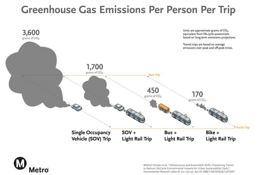
Metro’s First Last Mile Plan is part of its overall sustainability strategy. As the above chart shows, to the extent that people chose to take transit and/or bike, transportation’s environmental benefits increase. Walking is even better, though not shown in the above chart. Similar graphics could be developed for other pollution — air, water, noise — and for public safety, public health and more. For all these reasons, the first last mile priority is fostering walking and bicycling.
To date, Metro hasn’t had any significant coordinated investment in encouraging walking and bicycling to Metro Rail stations. To some extent, the contrary is true; Metro has invested hundreds of millions of dollars to build free parking, but that’s another story. Even without significant investment, Metro on-board surveys show that roughly 90 percent of their transit riders arrive without driving or being dropped off. For Metro rail, roughly 75 percent of riders already arrive without any driving.
Investment in first last mile facilities can, as the plan states (p. 3), “extend the reach of transit, with the ultimate goal of increasing ridership.” It can also shift existing riders on to healthier, more sustainable modes. These facilities also make areas around Metro stops more pleasant and more commercially viable.
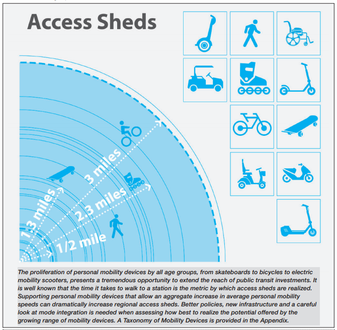
Metro’s plan shows the general distances that people will walk, bike or skate to get to a transit stop, calling these “access sheds.” According to the plan, to get to transit, people will walk roughly half a mile, or bike roughly three miles.
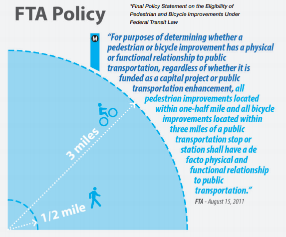
The walking and bicycling distances, though shorter than what many people who use active transportation daily might expect, are actually specified in federal transportation policy.
From these access sheds, Metro’s plan comes up with a “bold concept” which it calls: “the Pathway.”
From the plan:
The Pathway is a proposed county-wide, transit access network designed to reduce the distance and time it takes people to travel from their origins to stations and from stations to destinations, while simultaneously improving the user experience. At its core, the Pathway is a series of active transportation improvements that extend to and from Metro Rail and BRT stations.
The Pathway extends the positive experience of the transit user. It is intuitive, safe, efficient, universally accessible and fun.
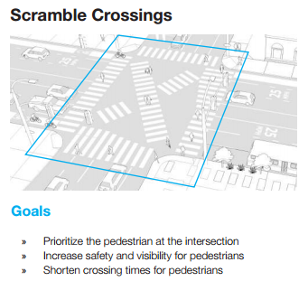
The plan then details an extensive toolbox of pedestrian and cycling facilities that would comprise the Pathway. These include nearly all of the livability improvements that Streetsblog readers know and love: mid-block crosswalks, signage, scramble crossings, landscaping, bus-only lanes, bike lanes, bike share, car share, even protected bike lanes, which the plan renames “rolling lanes”.
These are exactly the kind of facilities that are needed to make it safe and convenient to walk and bike to Metro.
The plan subsequently includes generic sample Pathway illustrations to show how various features can be combined. After those, the plan includes three real Metro station case study sites: 103rd Street/Watts Blue Line Station, Wilshire/Normandie Purple Line Station, and North Hollywood Red/Orange Line Station. Though these existing station case studies are detailed and well-thought out, that plan states that they are “meant for illustrative purposes only” with more detailed site-specific planning needed.
In April, Metro approved the First Last Mile Strategic Plan, as well as a series of First Last Mile pilot projects, anticipated to be funded by the current round of the state Active Transportation Program. The pilots are basically local jurisdiction projects that connect with Metro rail stations. These projects were already underway before Metro’s plan, so Metro is sort of re-branding them as first last mile:
- 17th Street/Santa Monica City College Station (Expo Line, Phase 2) First Last Mile Enhancements
- Exposition/Bundy Station (Expo Line, Phase 2) Multi-Modal Connectivity Enhancements
- Arcadia Gold Line Station (Foothill Extension 2A) Pedestrian Linkage Project and Bicycle Facility Improvements
- Duarte Gold Line Station (Foothill Extension 2A) Pedestrian Improvements
- Unspecified projects at Metro Red Line Universal City and North Hollywood stations.
Overall, it’s important that Metro is acknowledging that transit trips are multi-modal, and that Metro’s passengers’ trip experiences extend outside the boundaries of Metro’s stops and stations.
Nonetheless, there are a few things missing from the plan:
- Connections to Metro Bus: The First Last Mile plan is too narrowly focused on Metro’s rail system stations. Similar first last mile issues exist throughout the Metro Bus system. Many bus stops in population-dense areas have greater numbers of daily boardings than outlying Metro rail stations. A thorough Metro first last mile program would include bus, rapid bus, BRT, and rail stops. Ideally, it could extend beyond Metro’s direct purview to municipal bus system stops and even Metrolink stations. Thanks to UCLA Planning graduate student Daniel Berez for raising the lack of bus connections at Metro’s April board meeting.
- Missing the Bike Shed: After stating that the bicycling access shed extends a 3-mile radius from each transit stop, all the First Last Mile Plan examples design for only a half-mile radius. Especially as Metro proceeds with implementation of regional bike share, it’s important that Metro consider a sphere of influence well beyond a half-mile from its transit stops.
- Lack of Funding: Despite billions of dollars for building rail, there’s no Metro funding source for implementing first last mile improvements that will make rail successful. Pilot projects are anticipated to be funded by the state using federal pass-through monies, and implemented by local cities. Construction of rail, road, and parking lots is expensive. Walking and bicycling facilities are relatively cheap. Where is Metro’s leadership on funding for extending the reach of its own transportation system? Perhaps first last mile will be included in Metro’s Short Range Transportation Plan underway? One potential future funding source would be the proposed “Measure R2.” Move L.A.’s straw man proposal includes a 3 percent first last mile set-aside in its proposed new rail project funding.
Some Metro facilities have included active transportation facilities: the Expo Line bikeway, and the Orange Line bike path. Generally, though, Metro has treated these facilities as peripheral, and only included them at the insistence of local cities and communities. With Metro’s new embrace of first last mile planning and facilities, Metro can now fully partner with local jurisdictions and make great safe places to walk and bike at each end of every transit.
In the long run, Metro will need to include first last mile facilities as a component of all its transportation system planning. When a new bus line is established, a new BRT facility is installed, or a new rail station is built, Metro can respect its customers by including new walkways, bike share, and other first last mile features.

Streetsblog has migrated to a new comment system. New commenters can register directly in the comments section of any article. Returning commenters: your previous comments and display name have been preserved, but you'll need to reclaim your account by clicking "Forgot your password?" on the sign-in form, entering your email, and following the verification link to set a new password — this is required because passwords could not be carried over during the migration. For questions, contact tips@streetsblog.org.


