Draft Pasadena Pedestrian Plan Public Feedback Period Ends, to Head to City Council Soon
The city of Pasadena wrapped up its community feedback period on Wednesday for its draft pedestrian master plan.
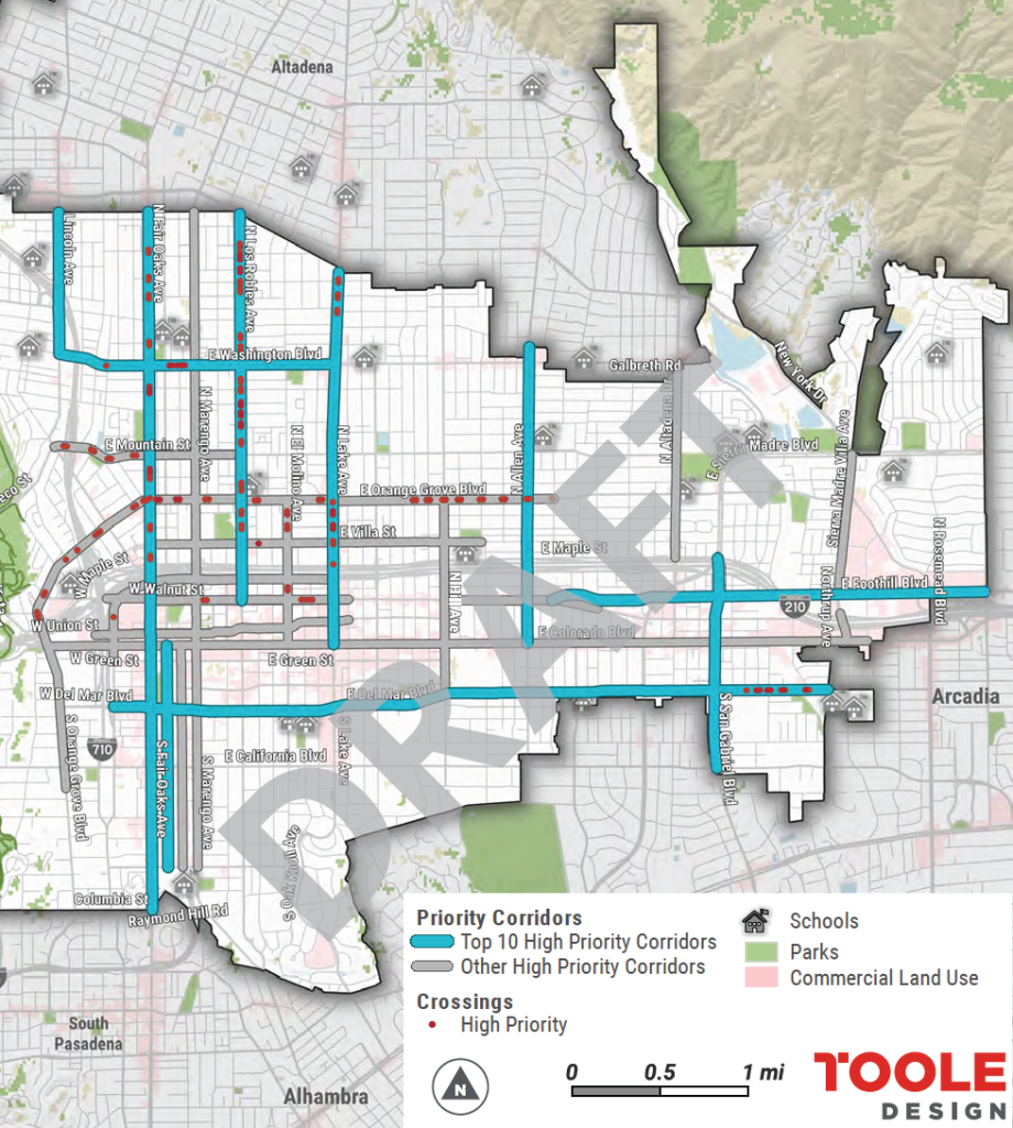
Pasadena Walks!, the city’s 2022 pedestrian plan, would prioritize and guide investments to create a safer and more walkable Pasadena. The plan identifies 10 high priority corridors, multiple high priority crossings and multiple secondary corridors.
Priority corridors include:
- Allen Avenue, from the north city limit to Colorado Boulevard
- Del Mar Boulevard, from Pasadena Avenue to the east city limit
- Fair Oaks Avenue, from the north city limit to the south city limit
- Foothill Boulevard, from Walnut Street to the east city limit
- Lake Avenue, from the north city limit to Colorado Boulevard
- Lincoln Avenue, from the north city limit to Washington Boulevard
- Los Robles Avenue, from the north city limit to Walnut Street
- Raymond Avenue, from Colorado Boulevard to E. Glenarm Street
- San Gabriel Boulevard, from Maple Street to California Boulevard
- Washington Boulevard, from Lincoln Avenue to Lake Avenue
With the public comment period ended, the plan is likely headed to city council in the coming weeks. Members of the public can still email elected officials their feedback on the plan at correspondence@cityofpasadena.net.
The Pasadena Complete Streets Coalition announced in their February newsletter a few ideas they would like to see in the soon to be considered Pasadena Pedestrian Plan.
- Specific recommendations regarding what street improvements are to be implemented and where to implement them.
- A clear timeline for implementing the plan in order to evaluate progress and ensure accountability.
- Breaking up Orange Grove Blvd into two different segments and place the Orange Grove Blvd segment west of Lake Ave into the “Top 10 High Priority Corridors”.
- Evaluate the potential of creating a dedicated funding source for pedestrian improvements.
- Include the intersections of Washington Boulevard at Hudson Avenue and Washington Boulevard at Palm Terrace into the list of priority intersections.
The deadline to submit public comment on the draft plan was February 1, 2022, but people can still email city council, where it will eventually be addressed at a future meeting.
SBLA San Gabriel Valley coverage, including this article and SGV Connect, is supported by Foothill Transit, offering car-free travel throughout the San Gabriel Valley with connections to the new Gold Line Stations across the Foothills and Commuter Express lines traveling into the heart of downtown L.A. To plan your trip, visit Foothill Transit. “Foothill Transit. Going Good Places.”
Sign-up for our SGV Connect Newsletter, coming to your inbox on Fridays.

Read More:
Streetsblog has migrated to a new comment system. New commenters can register directly in the comments section of any article. Returning commenters: your previous comments and display name have been preserved, but you'll need to reclaim your account by clicking "Forgot your password?" on the sign-in form, entering your email, and following the verification link to set a new password — this is required because passwords could not be carried over during the migration. For questions, contact tips@streetsblog.org.