Thirteen Fun Family-Friendly Bike Rides Accessible Via Metro Transit
Parents – your child finally learns how to ride a bike, but, without packing bikes up into a car, where can L.A. families ride? CicLAvia and other open streets events are great places to ride together, but they only come around a handful of times each year.
As part of Streetsblog L.A.’s occasional #streetsr4families coverage, we’ve compiled thirteen transit-accessible family-friendly places to bike.
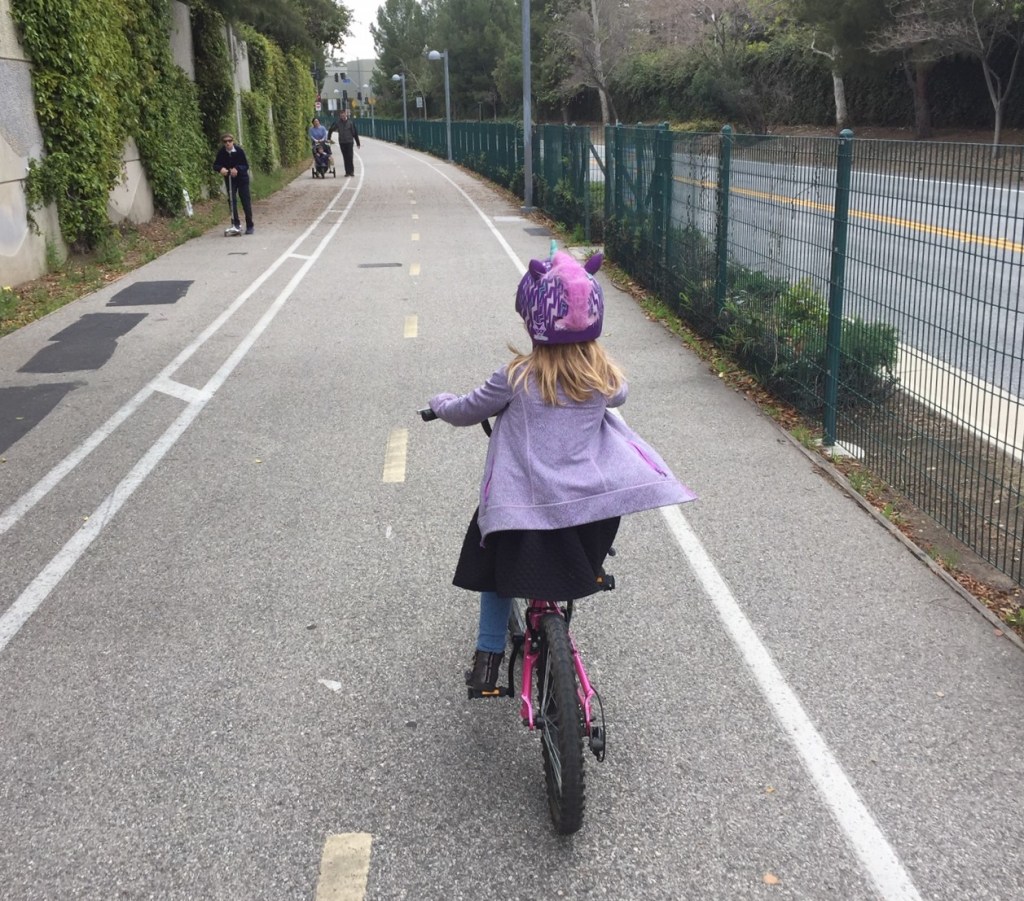
These are all safe, enjoyable family-friendly rides. My 6-year-old daughter and I have field tested nearly all of these. With water and food breaks, my daughter can pretty easily ride 20+miles at CicLAvia or on a bike path. To get to paths/rides, we generally ride together on L.A. sidewalks because I don’t really trust that streets – even with bike lanes – would be safe for her at this age.
These paths aren’t just for kids – they’re great for car-free excursions for adult cyclists, too.
GENERAL NOTES
I’ve used Metro’s new letters for these rail and bus lines. For historic color designations, see the graphic on the right. I haven’t renamed the bikeways (Expo and Orange Line) that run along a couple of these lines as, for now, these bike path names remain the vernacular. (The naming conventions on bikeways are somewhat inconsistent overall. Some names change between adjacent segments. The county calls their paths “trails.” All of these are “multi-use paths” but get called “bikeway” or “bike path” in different places. I’ve tried to use the most common names, which are not always the official names.)
To view bike facilities on the Google Maps links below, you may need to click on “Menu,” then on “Bicycling.”
CAUTIONARY NOTE
Please use these facilities carefully. They’re safe, fun, easy places to ride… but you as a parent will need to gauge the appropriateness for where and how far your child can ride, depending on age and experience. Young kids need you to ride with them to keep them safe. When my daughter first learned to ride, some of the minor downhills (including crossing under bridges on the L.A. River path) could spook her when she got going too fast downhill. When she and I ride together, we haven’t had any problems on any of these facilities.
While these paths are safe from car traffic, many of them feature some at-grade crossings where cyclists interact with drivers. Accompany your child closely at crossings. Teach your child appropriate crossing behavior for stop signs and signalized intersections.
To get to the paths, there are often a few blocks of sidewalk riding – which is often the most dangerous part of a family ride. Be mindful, careful, and ride in ways that are most visible to drivers. Be aware that drivers may not expect cyclists on the sidewalk, so ride cautiously and stay close to your child.
Popular paths can sometimes be crowded with other riders, pedestrians, skaters, runners, etc. Many paths experience some homelessness presence. Work with your child/children to be aware of other path users, to ride to the right, and to be courteous to others.
HOW TO PUT YOUR BIKE/S ON METRO RAIL
Metro allows bikes on trains at no extra cost to the base fare – currently $1.75. Kids under five ride free. More information on how to pay at Metro webpage.
Train cars hold plenty of bikes (I’ve seen a dozen or so on some CicLAvia days) but it’s important to not block other riders, so keep bikes in the designated areas. Look for a yellow bike sticker on the outside of the train car. I bring a couple of bungee cords to secure our bikes.
Also see Metro’s bike guidance – click on the “Bikes & Transit” tab at Metro’s bike webpage.
BIKEWAYS ACCESSIBLE VIA METRO RAIL
Metro A (Blue) Line
1. A Line – Watts Towers bike path
- There are two short bike paths at the Watts Towers – in total about a half-mile of path. One is in the park immediately north of the towers, the other is on the west side of Graham Avenue. These are short for a bike ride, but they do combine well with a trip to see the iconic towers (which, at present, are undergoing restoration and conservation, but still largely visible). Contact the Watts Towers Art Center for tours, which take place Thursday-Sunday.
Directions: Google Map. Exit the A Line at 103rd Street Station. Go one block east on 103rd, then right two blocks on Graham Avenue. Bikeways are located on both sides of Graham. The Watts Towers, located at 1727 East 107th Street, are visible from the A Line Station.
2. A Line – Lower Compton Creek bike path
- The county’s 1.9-mile Lower Compton Creek Bike Path is located adjacent to the Metro Del Amo Station. This part of Compton Creek (an L.A. River tributary) has an earthen bottom, so is a pretty good place to see ducks and other birds. L.A. County wateway bikeways are closed during rainy weather.
Directions: Google Map. Exit the A Line at Del Amo Station. Go to the south end of the parking lot, then turn left/east on the sidewalk on Del Amo Boulevard. Cross the creek and enter the bike path on your left. (The L.A. River Bike Trail isn’t far from Del Amo, but, especially with kids, be very careful bicycling under the 710 Freeway to access it. It’s safer and easier to access from the Wardlow Station or from Downtown Long Beach – see below.)
3. A Line – LARIO (Los Angeles River/Rio Hondo) Bike Trail
- The county’s 25+mile LARIO (L.A. River/Rio Hondo) bike path is easily accessed from the Metro A Line in Long Beach, via either Wardlow or Downtown Long Beach stations. One fun way to ride this is to access the path from Wardlow, then ride one-way (about 5 miles) to board the A Line in downtown Long Beach.
Directions from Wardlow: Google Map. Exit the A Line at Wardlow Station. Cross Wardlow Road and bike west on the sidewalk. Continue west on 34th Street, on the left where Wardlow veers right. At the end of 34th, go through the Earth Day gate and up the ramp to the river path.
Directions from Downtown Long Beach: Google Map. Exit the A Line at Downtown Long Beach Station. Go south three blocks on the sidewalk on Pine Avenue. After crossing Shoreline Drive, enter the walk/bike path on the left. In the Shoreline/Aquarium area, the path can be pretty crowded with pedestrians. Keep right and turn right to ride along the water in the small harbor – near the kid-friendly Aquarium of the Pacific. Round the lighthouse, and continue westward along the L.A. River. The path continues through another (sometimes crowded) Catalina Landing area. Continue west to the Golden Shore Marine Biological Reserve (wetlands). The path runs along the north of the wetlands, then turns right onto the L.A. River path.
Metro B (Red) Line
4. B Line – Burbank Chandler bike path
- We live close to the B (Red) Line, so we ride the 3-mile-long Burbank Chandler Bikeway often. It’s my daughter’s favorite. It’s very flat, with few crossings, and it connects directly to the Metro North Hollywood Station. We often go a couple blocks off the path to get to garage sales, bakeries, restaurants, bookstores, etc. The path is mostly in the city of Burbank, with a portion in the city of Los Angeles.
Directions from the B Line: Google Map. Exit the B Line at North Hollywood. When exiting the station, go to the right/east side to surface on the east side of Lankershim. Bike east on the sidewalk – along the bus bays – to Fair Avenue. Go right/south on the Fair sidewalk. Cross Fair at the signal, and enter the bike path which runs between Chandler Boulevard and the Metro parking lot.
Combining the Burbank Chandler and L.A. River paths: A longish – about 15 miles – ride that my daughter and I enjoy combines the Burbank-Chandler path with the L.A. River path. We take the Red Line to North Hollywood, ride 3 miles on Burbank-Chandler, then 3 miles on Burbank sidewalks, then 8 miles on the L.A. River, then return home on the L (Gold) Line. From the B Line, go east to the end of the Burbank Chandler path (directions above). At the end of the path, take the sidewalk east one long block to Victory Boulevard. Turn right/south on Victory, riding on the sidewalk. Be careful with driveways and crossing streets. Turn left/east at Riverside Drive. We ride on the sidewalk, which ends, then continue briefly carefully in the bike lane. Turn right (at Victory/Sonora) to stay on Riverside Drive. Cross the bridge, and enter the L.A. River bike path on the left (or the right, if the gate is unlocked.) Continue 8.5 miles downstream on the L.A. River path, then, carefully, ride sidewalks on North Figueroa and Avenue 26 to get to the Lincoln/Cypress L (Gold) Line Station.
Metro E (Expo) Line
5. E Line – Ballona Creek bike path
- The 6-mile Ballona Creek Bike Path starts at Syd Kronenthal Park, just off the E (Expo) Line. It connects with the county beach bike path in Marina Del Rey. Much of Ballona Creek is concrete, but closer to the mouth there are wetland areas good for bird-watching. See below to combine Ballona and Beach paths. Path is closed during rainy weather.
Directions from La Cienega/Jefferson Station: Google Map. Exit the E Line at the west end of the La Cienega/Jefferson Station. Ride west on the Expo bike path, located just south of the station (west of La Cienega Boulevard). Cross Jefferson Boulevard at the light. Cross Ballona Creek, then turn right to take the ramp down to the start of the Ballona Creek path.
Directions from Culver City Station: Google Map. Exit the E Line at Culver City. Go downstairs to the east end of the station, at Washington Boulevard. Go one block northeast on the sidewalk on Washington, then cross Washington and National Boulevards. Ride southeast on the sidewalk on the north side of National. The bike path entrance is in about 300 feet. Continue east about half a mile and, at the far end of the park, the entrance ramp down to Ballona is on the left.
6. E Line – Expo bike path
- From USC to Santa Monica along the E Line, there is a nearly continuous bikeway consisting of bike path, bike lanes, and sharrowed bike route. The longest section of bike path extends about four miles from the 17th Street/Santa Monica College Station (in Santa Monica) to Overland Avenue – just east of the Westwood/Rancho Park Station. Two other short path sections extend between the Palms and Culver City stations and between the Culver City and La Cienega/Jefferson Stations. A few street crossings are not particularly convenient (especially at Pico Boulevard) but follow the Expo right-of-way and you’ll find the path.
Directions from E Line: Google Map. Exit one of several E Line Stations. For the 4-mile bikeway, exit: 17th Street, 26th Street, Bundy, Sepulveda, or Westwood. For a shorter segment, exit Palms, Culver City, or La Cienega/Jefferson. Bike path runs adjacent to all of these stations, except for Culver City where it is across the street (either east or west).
7. E Line – Beach bike path
- The Beach bike path is located about a half-mile from the E Line terminus in downtown Santa Monica. Most of the way to the beach path is easy and convenient to bike, via Santa Monica’s protected bike lane on Colorado Avenue.
Directions from the E Line: Google Map. Exit the E Line at Downtown Santa Monica Station. Go southwest on the protected bike lane on Colorado Avenue. Cross Ocean Avenue and go left/south on the sidewalk. Cross Moomat Ahiko (basically a PCH on-ramp), then turn right down Seaside Terrace, which ends at Ocean Front Walk. Continue right or left, then turn toward the beach to get to the beach path.
Combining the Ballona and Beach paths: There’s a fairly long one-way ride – about 13 miles – that my daughter and I have done. Exit the Expo Line at La Cienega/Jefferson and take the Ballona Path. Near the end of Ballona, turn right on the Marvin Braude bike path through Marina Del Rey (and a short stretch of sidewalk on Washington Boulevard) to get onto the beach bike path in Venice. Continue north to the Santa Monica Pier and catch the Expo Line there.
Metro L (Gold) Line
8. L Line – San Gabriel River Trail
- It’s very easy to access the county’s 35+mile San Gabriel River Bike Trail from the Duarte L Line Station, though the connection (which opened in 2016) is not well marked, and does not show on Google Maps’ bicycle directions. All L.A. County river paths are closed during rainy weather.
Directions from the L Line: Google Map. Exit the L Line at Duarte/City of Hope Station. On the south side of Duarte Road – across from the Metro Station, there is an unmarked open gate. Go through the gate, continue to the right – briefly on a dirt road. Access the San Gabriel River Trail on the left in about a third of a mile. The trail initially climbs up onto the Santa Fe Dam, where riders can go right to head downstream, or continue straight to head upstream.
9. L Line – L.A. River bike path
- There is no simple convenient access to the central 8.5-mile Glendale Narrows L.A. River Bike Path from the Metro rail system. The easiest connection is via the L (Gold) Line Cypress Park/Lincoln Heights Station, though, with kids, that means traveling about a half-mile on sidewalks – including crossing several 110 Freeway on-ramps. My daughter and I have done this several times, but it’s not really for beginners.
Directions from the L Line: Google Map. Exit the L Line at Lincoln/Cypress Station. Go west on the sidewalk on Avenue 26. Be very careful crossing freeway on-ramps. Turn left/south on North Figueroa Street (or alternately, carefully cut through the McDonald’s parking lot to get to Figueroa). Continue south on the east sidewalk on Figueroa, carefully crossing the freeway on- and off-ramps. At the traffic circle, cross San Fernando Road and Riverside Drive to access the River bike path at the base of Riverside Drive Bridge.
(An alternate way to take transit to the central L.A. River path: take the Metro 180-181 bus. We board at Vermont/Hollywood – near the Sunset B Line station – and exit at Los Feliz/Glenfeliz in Atwater Village.)
10. L Line – L.A. State Historic Park
- There is no actual designated bike path in the 35-acre Los Angeles State Historic Park, but bikes easily share the walking paths there – as well as the nice wide park-frontage sidewalk along North Spring Street. The surface is decomposed granite, conditions essentially like a very good dirt road. It can be a bit slippery for beginners – my daughter fell once there when her tire slipped, though she got used to the surface and enjoyed it afterwards.
Directions from the L Line: Exit the L Line at Chinatown Station. Head north about 500 feet on the sidewalk on North Spring Street to get to the park.
BIKEWAYS ACCESSIBLE VIA METRO BUS RAPID TRANSIT (BRT)
Bikes on Bus Note: Metro BRT buses have less bike capacity than Metro rail. For groups of more than three cyclists, it is generally not possible to ride the bus together. G (Orange) Line buses pretty much all hold three bikes, though racks fill quickly, so it’s easiest to board at the ends of the line in North Hollywood or Chatsworth. J (Silver) Line buses mostly hold two bikes. If you’re unfamiliar with putting bikes on buses, read how or watch various videos showing loading instructions. Metro front racks hold typical child-size bikes (though very small training-wheel bikes are probably better brought on board.) Folding bikes can be brought on board buses.
Metro G (Orange) Line
11. G Line – Orange Line bike path
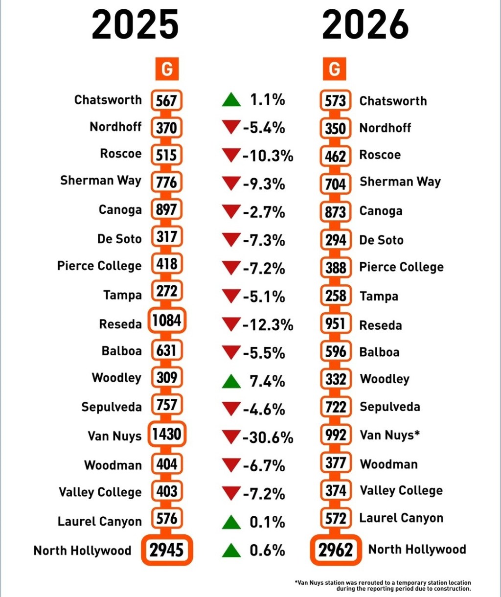
- Running parallel to the Metro G Line busway is 16 miles of bike path extending from Chatsworth Station to just below Valley College. For the two miles of G Line between Coldwater Canyon and North Hollywood Station, there is no bike path, just on-street bike lanes – not easily navigated by young kids. The Orange Line bike path is flat, well landscaped, pleasant, though has at-grade crossings at lots of big streets.
Directions from G Line: Google Map. Exit any G Line station between Valley College and Chatsworth. Find the bikeway parallel to the BRT roadway.
12. G Line – Sepulveda Basin bike paths
- The 2000-acre Sepulveda Basin park complex has about ten miles of bike paths, not all of which show up on the official city Rec and Parks map or Google maps. The bike paths connect to play areas along Lake Balboa, several bathrooms, natural areas (including a natural soft-bottom stretch of the L.A. River), and to the cross-valley Orange Line bike path.
Directions: Google Map. Exit the G Line at Balboa Station or Woodley Station. From Balboa, take the a bike path south along the east side of Balboa Boulevard, keeping left to get to Lake Balboa. From Woodley, bike south along the west side of Woodley Avenue, then to get to Lake Balboa, turn right at the unmarked bike path entrance about 400 feet south of the station. For a ~5-mile loop, take the paths paralleling Woodley Avenue, Burbank Boulevard, Balboa Boulevard, and Victory Boulevard.
Metro J (Silver) Line
13. J Line – LARIO (Rio Hondo) Trail
- The upper portion of the 25+mile LARIO trail runs right behind Metro’s El Monte Transit Center. Kid-friendly attractions along the Rio Hondo path include the San Gabriel Valley (formerly El Monte) Airport (watch small planes take off and land), the Montebello Barnyard Zoo, and numerous parks at the Whittier Narrows Recreation Area. Path is closed during rainy weather.
Directions: Google Map. Exit the J Line at El Monte. Head to the front (east side) of the station. Go right, then right again (at the Metro Bike Hub) and ride 700 feet west on the small access road. Follow signs for “Rio Hondo Trail.” At the third stop sign, turn right onto the sidewalk to get to the ramp down to the Rio Hondo path.

Streetsblog has migrated to a new comment system. New commenters can register directly in the comments section of any article. Returning commenters: your previous comments and display name have been preserved, but you'll need to reclaim your account by clicking "Forgot your password?" on the sign-in form, entering your email, and following the verification link to set a new password — this is required because passwords could not be carried over during the migration. For questions, contact tips@streetsblog.org.