
Who Are We Building Transit For?

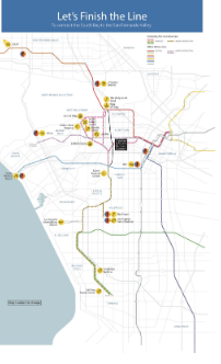
With the Crenshaw line opening this year, Metro has already begun exploring potential alignments for a Northern Extension connecting the Expo (E) and Red Lines. During last year’s feasibility/alternatives analysis process, Metro offered five different alignment options (seen above). The next step will be for Metro staff to bring two alternative alignments to the board for approval so it can move forward with an Advanced Alternatives Screening Study.
Every major infrastructure project Metro undertakes should include a holistic view of improving transit service in the area in question. This includes First/Last Mile improvements including transit station improvements, but also, I’d argue, complementary transit service in the area.
Of the two radically different alternatives Metro staff appear to favor – A2 and C – Alternative C is best suited to function as a fruitful addition to the regional transit network on its own, and also give us the freedom to concomitantly pursue such needed network-bolstering improvements.
The proposal Metro staff have presented favorably and in great detail many times over the past few months, however, has been Alternative A2 – the more circuitous, slow, and expensive route. This alignment posits that the train would act as a local circulator, prioritizing hitting every “destination” and as a regional connector. This is really an impossible marriage, and a “compromise” that will not lead to markedly better service for North-South travel, which is what this extension is ostensibly about.
It makes perfect sense that West Hollywood and WHAM, the advocacy group it helped start, appear to also favor A2. They have consistently sought an alignment that rides the spine of WeHo, travelling under Santa Monica Blvd through most of the city. And they have even gone so far as to accelerate planning of the line with an upfront investment to fast track the environmental analysis – something that has encouraged Metro to look into ways to hasten the 2041 expected groundbreaking for the project.
Appreciated as their enthusiasm (and investment) is, Metro must think bigger. Both regionally and locally at the same time, but not necessarily with the same line.
Alignment C, running under La Brea, would offer a direct north-south line addition to a rail network grid. Slotting into the system as a fast and efficient high-capacity transit line between the existing Red Line to the east and the future Sepulveda Transit Corridor to the west while being the most cost-efficient alternative outright, it provides a better regional transportation option while setting the stage for complementary local improvements.
Tunnel Vision?
Conceptualizing the Northern Extension as a backbone rapid North-South rail addition to our network is the best improvement we, the transit riding and voting public, could make to our rail network at large. This would allow us to also pursue a “Network Concept” suite of improvements in the area to lead to a more holistic and comprehensive improvement of transit in the area.
It also would allow us to avoid a particular kind of insidious tunnel vision which is the expectation that rail is the only real transit mode that people will take. This way of seeing the world also views making direct rail connections to cultural and shopping destinations as the most important connections to make. This myopia leaves out the bus, in whatever form, as an integral part of the system: one that feeds more regional-scale rail lines, and can stand on its own.
This approach is pervasive because the leaders of our cities, counties, states, and transit agencies by and large don’t ride their own system, much less the bus. Nor do their most vocal constituents (or the ones they seek out for input).
As a result, the discourse around transit is generally limited to contemplation of ridership estimates, generators, and future riders as opposed to the actual quality of the service provided.
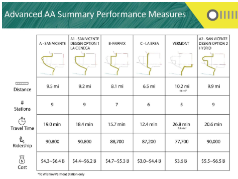
Even if we use this framing and compare the projected ridership of 87,200 for La Brea to 90,000 for Alternative A2 (a 3.2% difference), it’s clear that neither “destinations” like the Beverly Center, nor the built environment around San Vicente Blvd. and Santa Monica Blvd. (as compared to La Brea) would be the main drivers of ridership — the connections to the trunk lines of the network are.
If we then eschew projected ridership to focus on service (as I’d argue we should), we see that building the circuitous A2 route would add 3.6 miles of (largely underground) track. It’d also require an additional 8.2 minutes of travel time between Hollywood/Highland and the Expo Line and cost $2.2-2.5 billion more to build (using the highest-cost estimates for each, $6.54B for A2 and $4.36B for La Brea, respectively).
The time delay would be most burdensome for travelers riding the length of the Crenshaw/LAX line – it will be 11.5 miles from the Redondo Beach station to the Expo Line.
The circuitousness of A2 also goes against best practices which recommend: “long routes prioritize directness and be designed to mitigate the cumulative impacts of delay.” And as seen in Better Buses, Better Cities, higher ridership routes have primarily tended to be straight, while lower ridership routes largely squiggle.
The Crenshaw/LAX Northern Extension does not have a clear timeline yet. This whole process is, by necessity, trying to plan for years into the future, where we don’t know for certain how transportation might change around us. But however the future changes, geometry doesn’t. Straightforward, high-capacity trunk lines (both rail and bus), separated from private auto traffic are, and will remain, the best way to move lots of people where they need to go, and should be our first priority.
Not a Zero-Sum Game
Noticeably absent in the consideration of the route alternatives thus far has been any discussion about how to otherwise improve transit in, through, and to and from West Hollywood that doesn’t solely involve the Northern Extension.
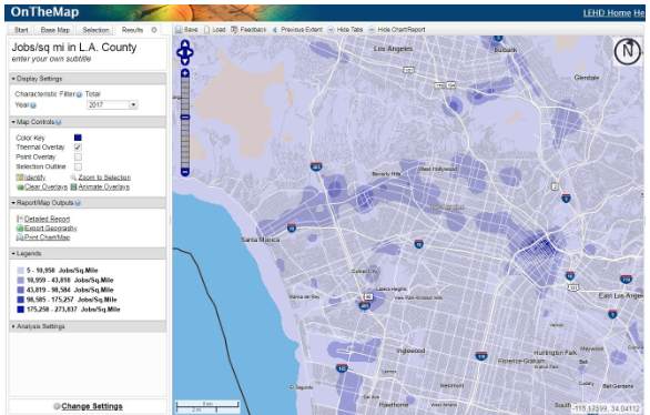
As the map below shows, at a regional scale, the grand arc from Santa Monica to DTLA has comparatively a lot of jobs and a lot of people. This is why the 720 bus – running along Wilshire from Santa Monica to East LA – has the highest bus ridership in the system. According to Metro’s NextGen studies,the 720 had 28,849 weekday daily boardings, most in the system. This people-job density is why the parallel Expo Line has performed so well (and could do even better with the signal priority it deserves). Expo is providing a transit-dedicated corridor for this East-West arc. So will the under-construction Purple Line Extension.
If Metro is going to spend billions on a rail line, having the fastest and most frequent connection between the Crenshaw/LAX Line and these East-West backbone routes is crucial. Both regionally and for the specific communities it would traverse, from Inglewood to Hollywood.
The extra construction time, projected ride times, length, and billions of dollars Alternative A2 adds matters. A circuitous, incredibly expensive route precludes other opportunities to build out and improve our Metro system, both at large and locally in the Study Area.
Take transit in West Hollywood, for example, which is relatively good for the region and for the diverse population it serves. According to Metro’s NextGen studies, the following bus lines average over 5.1 trips/hour (which roughly translates to an average of a bus every 12 minutes):
- 2/302 (Sunset): 7.2 trips/hour
- 4/704 (Santa Monica): 9.8 trips/hour
- 14 (Beverly): 7.6 trips/hour
- 16/17/316 (3rd St): 12.1 trips/hour
- 30/330 (San Vicente): 5.1 trips/hour
- 212/312 (La Brea): 7.4 trips/hour
In addition to these higher-frequency lines, West Hollywood runs the CityLine service, as well as the PickUp and Sunset Trip as local services.
These routes could still be improved, especially with regard to reliability. Alternative C offers an opportunity for us to do that by using the $2.5B “savings” (from not building A2) to help enhance other parts of the network in the area.
As described below, the Network Concept would pair a subway under La Brea (with the stations proposed in the initial analysis) with a rail spur along Santa Monica Blvd, a dedicated-lane Bus Rapid Transit (BRT) on San Vicente and tactical bus lanes in the area.
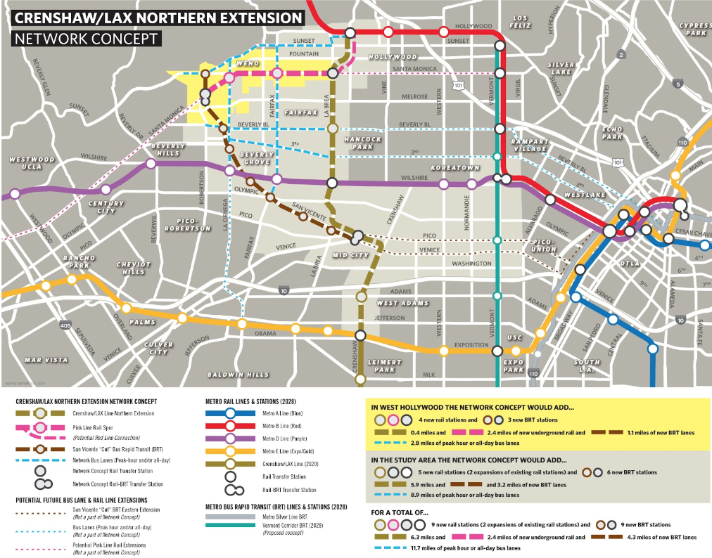
The 2.4-mile “Pink Line” underground rail spur could be built from Santa Monica/San Vicente heading east. Besides the stations that would be built as part of Alternative C (Hollywood/Highland and Santa Monica/La Brea), the Pink Line could have underground stations at Santa Monica/Fairfax, Santa Monica/La Cienega, and Santa Monica/San Vicente (as called for in Alternative A2). A rail yard could be incorporated into the District 7 Metro yard.
The Purple Line Extension is costing roughly $930 million per mile to build, so a $2.4B Pink Line rail spur is broadly reasonable. Such a plan isn’t out of scope with the current studies, either, if Metro chose to explore it. And it could serve as a jumping off point for building out more of the network in the future along Santa Monica Blvd., one of the County’s most trafficked corridors.
The remainder of the “savings” would go toward building a BRT line with separated transit lanes and train-style stations from San Vicente/Sunset to the Mid City Transit Center at Pico-Rimpau.
Installing BRT would have the added benefit of maintaining a connection between the two sides of San Vicente, impossible with an at-grade train. The existing median could easily be preserved and enhanced. A protected bikeway could also be built as part of the same project, making San Vicente Los Angeles’ first, true Complete Street.
This BRT, let’s call it the “San Vicente Cut” (see the dark brown dotted line in the map above), would enable the existing 30 and 330 buses to operate in transit-dedicated lanes. A new limited-stop BRT service could operate along its length from Sunset to the Mid City Transit Center, connecting along the way to the Pink Line rail spur, the Purple Line (via a short line), and the Crenshaw/LAX Line, as well as the R7 and other major bus routes currently operating at the Mid City Transit Center.
Lastly, the Network Concept would be rounded out with the implementation of a few tactical transit lane improvements on Sunset Blvd., Beverly Blvd., 3rd St., La Cienega Blvd, and Fairfax Ave. These could all be curb-running options, functioning as either peak-hour bus lanes or 24/7 bus lanes. These improvements would offer people a true choice: to take transit and opt out of traffic, improving service dramatically and changing the paradigm of transit in the area.
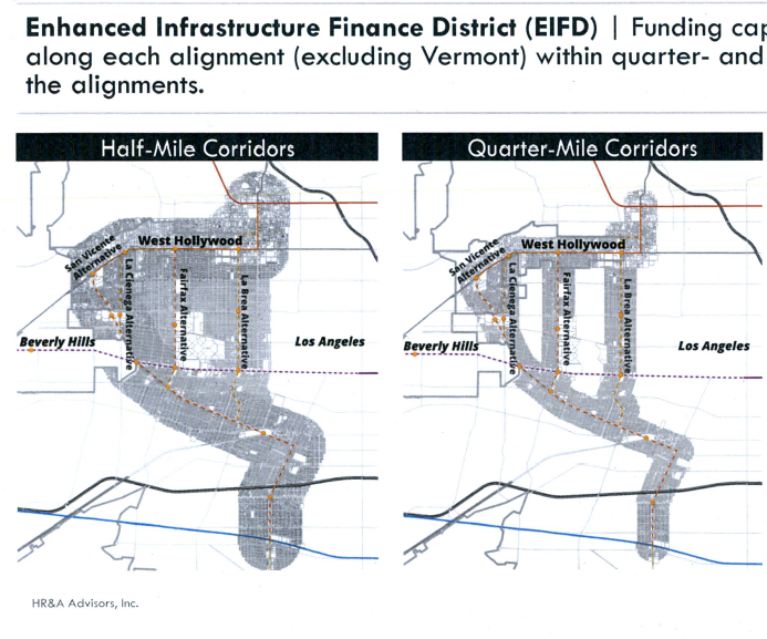
To finance the La Brea extension, Pink Line spur, and San Vicente BRT, Enhanced Infrastructure Finance Districts (whereby future appreciations in property taxes in a defined area are diverted to a transit project) could be instituted for said alignments. A Half-Mile Corridor EIFD concept established for the Network Concept would cover most of the Study Area. One EIFD could be established, or individual EIFDs could be established (at potentially different rates) for rail and BRT alignments.
A distinct advantage with the Network Concept would be that these projects could be developed on their own schedules and could open as they are completed, continually improving the transit environment in a reinforcing virtuous cycle of better service leading to better lives for those currently riding transit, while attracting new or returned riders.
Peak-hour lanes on Sunset Blvd. could be opened almost immediately, funded by Measure M Local Return or West Hollywood directly, while other bus lanes could be opened as peak-hour or 24/7 bus lanes, also through Local Return funds. The San Vicente Cut BRT could be funded through an EIFD and, due to its less intensive construction and implementation, rolled out sooner than a rail line. Alternative C, a subway under La Brea, could be accelerated through an EIFD in concert with the Pink Line spur, packaged as one project.
The most important thing here is the vision of a successful and thriving, real, network-based transit system – one in which passengers can expect (and demand) six-minute-or-less headways, painless transfers, and a system in which bus and rail seamlessly feed into one other. That’s a real transit system, that’s what we should plan for. The map below illustrates what that system could look like.
Our future transit system’s health will rely on the decisions we make today. We must trust in best practices and look to improve the network. The Northern Extension must fit into that framework.
It is too important of a project not to.

Streetsblog has migrated to a new comment system. New commenters can register directly in the comments section of any article. Returning commenters: your previous comments and display name have been preserved, but you'll need to reclaim your account by clicking "Forgot your password?" on the sign-in form, entering your email, and following the verification link to set a new password — this is required because passwords could not be carried over during the migration. For questions, contact tips@streetsblog.org.


